imarkonis@itia.ntua.gr
+30-2107722860
Development of Database and software applications in a web platform for the "National Databank for Hydrological and Meteorological Information"
Duration: December 2009–May 2011
Budget: €140 000
Commissioned by: Hydroscope Systems Consortium
Contractor: Department of Water Resources and Environmental Engineering
Project director: N. Mamassis
Principal investigator: N. Mamassis
The Ministry of Environment, Physical Planning & Public Works assigned to a consortium of consultancy companies the Project "Development of a new software platform for the management and operation of the National Databank for Hydrologic and Meteorological Information - 3rd Phase within a GIS environment and relevant dissemination actions". In the framework of the specific project a research team of NTUA undertakes a part as subcontractor. NTUA delivers methodologies for further development of the databases and applications of the Databank and their migration into a web platform (including the experimental node openmeteo.org for free data storage for the public). Specifically, using the knowhow that has been developed in the past by Research Teams from the Department of Water Resources of the School of Civil Engineering a database system and software applications (included hydrological models) are created fully adapted for operation over the Internet. NTUA's contribution is primarily on the design of the new system and the hydrological and geographical database the development of distibuted hydological models, the adaptation of the system to the WFD 2000/60/EC and on supporting dissemination activities. Finally NTUA will participate in the technical support and pilot operation of the project after its delivery from the consortium to the Ministry.
More information is available at http://www.hydroscope.gr/.
Study of the management of Kephisos
Duration: June 2009–April 2010
Commissioned by: General Secretariat of Public Works
Contractors:
Delineation of the Arachthos River bed in the town of Arta
Duration: January 2009–February 2010
Commissioned by: Municipality of Arta
Contractors:
Y. Markonis, Y. Moustakis, C. Nasika, P. Sychova, P. Dimitriadis, M. Hanel, P. Máca, and S.M. Papalexiou, Global estimation of long-term persistence in annual river runoff, Advances in Water Resources, 113, 1–12, doi:10.1016/j.advwatres.2018.01.003, 2018.
Long-term persistence (LTP) of annual river runoff is a topic of ongoing hydrological research, due to its implications to water resources management. Here, we estimate its strength, measured by the Hurst coefficient H, in 696 annual, globally distributed, streamflow records with at least 80 years of data. We use three estimation methods (maximum likelihood estimator, Whittle estimator and least squares variance) resulting in similar mean values of H close to 0.65. Subsequently, we explore potential factors influencing H by two linear (Spearman's rank correlation, multiple linear regression) and two non-linear (self-organizing maps, random forests) techniques. Catchment area is found to be crucial for medium to larger watersheds, while climatic controls, such as aridity index, have higher impact to smaller ones. Our findings indicate that long-term persistence is weaker than found in other studies, suggesting that enhanced LTP is encountered in large-catchment rivers, were the effect of spatial aggregation is more intense. However, we also show that the estimated values of H can be reproduced by a short-term persistence stochastic model such as an auto-regressive AR(1) process. A direct consequence is that some of the most common methods for the estimation of H coefficient, might not be suitable for discriminating short- and long-term persistence even in long observational records.
T. Iliopoulou, S.M. Papalexiou, Y. Markonis, and D. Koutsoyiannis, Revisiting long-range dependence in annual precipitation, Journal of Hydrology, 556, 891–900, doi:10.1016/j.jhydrol.2016.04.015, 2018.
Long-range dependence (LRD), the so-called Hurst-Kolmogorov behaviour, is considered to be an intrinsic characteristic of most natural processes. This behaviour manifests itself by the prevalence of slowly decaying autocorrelation function and questions the Markov assumption, often habitually employed in time series analysis. Herein, we investigate the dependence structure of annual rainfall using a large set, comprising more than a thousand stations worldwide of length 100 years or more, as well as a smaller number of paleoclimatic reconstructions covering the last 12,000 years. Our findings suggest weak long-term persistence for instrumental data (average H = 0.59), which becomes stronger with scale, i.e. in the paleoclimatic reconstructions (average H = 0.75).
Additional material:
See also: http://dx.doi.org/10.1016/j.jhydrol.2016.04.015
Works that cite this document: View on Google Scholar or ResearchGate
Y. Markonis, S. C. Batelis, Y. Dimakos, E. C. Moschou, and D. Koutsoyiannis, Temporal and spatial variability of rainfall over Greece, Theoretical and Applied Climatology, doi:10.1007/s00704-016-1878-7, 2016.
Recent studies have showed that there is a significant decrease in rainfall over Greece during the last half of the pervious century, following an overall decrease of the precipitation at the eastern Mediterranean. However, during the last decade an increase in rainfall was observed in most regions of the country, contrary to the general circulation climate models forecasts. An updated high-resolution dataset of monthly sums and annual daily maxima records derived from 136 stations during the period 1940 – 2012 allowed us to present some new evidence for the observed change and its statistical significance. The statistical framework used to determine the significance of the slopes in annual rain was not limited to the time independency assumption (Mann-Kendall test), but we also investigated the effect of short- and long-term persistence through Monte Carlo simulation. Our findings show that (a) change occurs in different scales; most regions show a decline since 1950, an increase since 1980 and remain stable during the last 15 years, (b) the significance of the observed decline is highly dependent to the statistical assumptions used; there are indications that the Mann-Kendall test may be the least suitable method and (c) change in time is strongly linked with the change in space; for scales below 40 years relatively close regions may develop even opposite trends, while in larger scales change is more uniform.
Additional material:
See also: http://dx.doi.org/10.1007/s00704-016-1878-7
Works that cite this document: View on Google Scholar or ResearchGate
Y. Markonis, A. N. Angelakis, J. Christy, and D. Koutsoyiannis, Climatic variability and the evolution of water technologies in Crete, Hellas, Water History, 8 (2), 137–157, doi:10.1007/s12685-016-0159-9, 2016.
The Greek island of Crete is one of the southernmost regions of Europe with a long and rich history, which begins as early as ca. 3200 BC with the onset of the Minoan civilization. The archeological findings of well-designed water supply and sewerage systems in the Minoan Palaces and other settlements, with impressive architecture and high-level functionality, suggest a good degree of understanding of the basic water management techniques well before the scientific achievements of our times. Here we document characteristic examples of the ancient hydraulic works and the related hydro-technologies throughout the history of Crete. We summarize the pressures on the water resources in Crete in connection with climatic variability and investigate how and what could be learned from the past using recent findings and paleoclimatology. The reconstructions of the Eastern Mediterranean and more specifically of the Cretan climate using different proxy data (e.g. sediment, pollen, and historical archives) demonstrate a series of alternating periods with varying climatic characteristics with fluctuation lengths spanning from a few decades to many centuries. The synthesis of the on-going research on past climate offers the opportunity to create a picture of the Cretan climatic regime for the last 10,000 years, which could be useful to both hydrologists and archeologists. As the past is the key to the future, the information provided could help in developing modern integrated and sustainable water management plans.
Additional material:
See also: http://dx.doi.org/10.1007/s12685-016-0159-9
Works that cite this document: View on Google Scholar or ResearchGate
Other works that reference this work (this list might be obsolete):
| 1. | Angelakis, A. N., G. Antoniou, K. Voudouris, N. Kazakis, N. Delazios, and N. Dercas, History of floods in Greece: causes and measures for protection, Natural Hazards, doi:10.1007/s11069-020-03898-w, 2020. |
Y. Markonis, and D. Koutsoyiannis, Scale-dependence of persistence in precipitation records, Nature Climate Change, 6, 399–401, doi:10.1038/nclimate2894, 2016.
Long-term persistence or Hurst–Kolmogorov behaviour has been identified in many hydroclimatic records. Such time series are intriguing because they are the hallmark of multi-scale dynamical processes that govern the system from which they arise. They are also highly relevant for water resource managers because these systems exhibit persistent, for example, multi-decadal, mean shifts or extremes clustering that must be included into any long-term drought management strategy. During recent years the growing number of palaeoclimatic reconstructions has allowed further investigation of the long-term statistical properties of climate and an understanding of their implications for the observed change. Recently, the consistency of the proxy data for precipitation was strongly doubted, when their persistence property was compared to the corresponding estimates of instrumental records and model results. The latter suggest that droughts or extremely wet periods occur less frequently than depicted in the palaeoclimatic reconstructions. Here, we show how this could be the outcome of a varying scaling law and present some evidence supporting that proxy records can be reliable descriptors of the long-term precipitation variability.
See also: http://dx.doi.org/10.1038/NCLIMATE2894
Works that cite this document: View on Google Scholar or ResearchGate
P.E. O’Connell, D. Koutsoyiannis, H. F. Lins, Y. Markonis, A. Montanari, and T.A. Cohn, The scientific legacy of Harold Edwin Hurst (1880 – 1978), Hydrological Sciences Journal, 61 (9), 1571–1590, doi:10.1080/02626667.2015.1125998, 2016.
Emanating from his remarkable characterization of long-term variability in geophysical records in the early 1950s, Hurst’s scientific legacy to hydrology and other disciplines is explored. A statistical explanation of the so-called ‘Hurst Phenomenon’ did not emerge until 1968 when Mandelbrot and co-authors proposed fractional Gaussian noise based on the hypothesis of infinite memory. A vibrant hydrological literature ensued where alternative modelling representations were explored and debated eg ARMA models, the Broken Line model, shifting mean models with no memory, FARIMA models, and Hurst-Kolmogorov dynamics, acknowledging a link with the work of Kolmogorov in 1940. The diffusion of Hurst’s work beyond hydrology is summarized by discipline and citations, showing that he arguably has the largest scientific footprint of any hydrologist in the last century. Its particular relevance to the modelling of long-term climatic variability in the era of climate change is discussed. Links to various long-term modes of variability in the climate system, driven by fluctuations in sea surface temperatures and ocean dynamics, are explored. A physical explanation of the Hurst Phenomenon in hydrology remains as a challenge for future research.
Additional material:
See also: http://dx.doi.org/10.1080/02626667.2015.1125998
Works that cite this document: View on Google Scholar or ResearchGate
Other works that reference this work (this list might be obsolete):
| 1. | Vogel, M., Stochastic watershed models for hydrologic risk management, Water Security, doi:10.1016/j.wasec.2017.06.001, 2017. |
Y. Markonis, and D. Koutsoyiannis, Climatic variability over time scales spanning nine orders of magnitude: Connecting Milankovitch cycles with Hurst–Kolmogorov dynamics, Surveys in Geophysics, 34 (2), 181–207, doi:10.1007/s10712-012-9208-9, 2013.
We overview studies of the natural variability of past climate, as seen from available proxy information, and its attribution to deterministic or stochastic controls. Furthermore, we characterize this variability over the widest possible range of scales that the available information allows, and we try to connect the deterministic Milankovitch cycles with the Hurst–Kolmogorov (HK) stochastic dynamics. To this aim, we analyse two instrumental series of global temperature and eight proxy series with varying lengths from 2 thousand to 500 million years. In our analysis, we use a simple tool, the climacogram, which is the logarithmic plot of standard deviation versus time scale, and its slope can be used to identify the presence of HK dynamics. By superimposing the climacograms of the different series, we obtain an impressive overview of the variability for time scales spanning almost nine orders of magnitude—from 1 month to 50 million years. An overall climacogram slope of −0.08 supports the presence of HK dynamics with Hurst coefficient of at least 0.92. The orbital forcing (Milankovitch cycles) is also evident in the combined climacogram at time scales between 10 and 100 thousand years. While orbital forcing favours predictability at the scales it acts, the overview of climate variability at all scales suggests a big picture of irregular change and uncertainty of Earth’s climate.
Remarks:
Blog posts and discussions can be seen in Watts Up With That? (reproduced in I4U News), Climate Science: Roger Pielke Sr., Bishop Hill blog (reproduced in I4U News-2), The Resilient Earth (reproduced in The Global Warming Policy Foundation), Climate ExChange, Science Alerts, Science & Environmental Policy Project: Newsletter (reproduced in the Third Millennium Times), Archaeopteryx.
Errata: See some minor corrections in the related pdf file linked above. URL of the Corrigendum: http://dx.doi.org/10.1007/s10712-014-9278-y
Additional material:
See also: http://dx.doi.org/10.1007/s10712-012-9208-9
Works that cite this document: View on Google Scholar or ResearchGate
Other works that reference this work (this list might be obsolete):
| 1. | Varotsos, C. A., M. N. Efstathiou and A. P. Cracknell, On the scaling effect in global surface air temperature anomalies, Atmos. Chem. Phys., 13, 5243-5253, 2013. |
| 2. | Thompson, S. E., M. Sivapalan, C. J. Harman, V. Srinivasan, M. R. Hipsey, P. Reed, A. Montanari and G. and Blöschl, Developing predictive insight into changing water systems: use-inspired hydrologic science for the Anthropocene, Hydrol. Earth Syst. Sci., 17, 5013-5039, 2013. |
| 3. | Fleming, S. W., A non-uniqueness problem in the identification of power-law spectral scaling for hydroclimatic time series, Hydrological Sciences Journal, 59 (1), 73–84, 2014. |
| 4. | Glatzle, A., Questioning key conclusions of FAO publications ‘Livestock’s Long Shadow’ (2006) appearing again in ‘Tackling Climate Change Through Livestock’ (2013), Pastoralism: Research, Policy and Practice, 10.1186/2041-7136-4-1, 2014. |
| 5. | Hall, J., B. Arheimer, M. Borga, R. Brázdil, P. Claps, A. Kiss, T. R. Kjeldsen, J. Kriaučiūnienė, Z.W. Kundzewicz, M. Lang, M. C. Llasat, N. Macdonald, N. McIntyre, L. Mediero, B. Merz, R. Merz, P. Molnar, A. Montanari, C. Neuhold, J. Parajka, R. A. P. Perdigão, L. Plavcová, M. Rogger, J. L. Salinas, E. Sauquet, C. Schär, J. Szolgay, A. Viglione and G. Blöschl, Understanding flood regime changes in Europe: a state-of-the-art assessment, Hydrol. Earth Syst. Sci., 18, 2735-2772, 10.5194/hess-18-2735-2014, 2014. |
| 6. | Soon, W., V. M. Velasco Herrera, K. Selvaraj, R. Traversi, I. Usoskin, C.-T. A. Chen, J.-Y. Lou, S.-J. Kao, R. M. Carter, V. Pipin, M. Severi, S. Becagli, A review of Holocene solar-linked climatic variation on centennial to millennial timescales: Physical processes, interpretative frameworks and a new multiple cross-wavelet transform algorithm, Earth-Science Reviews, 10.1016/j.earscirev.2014.03.003, 2014. |
| 7. | Varotsos, C. A., C. L. E. Franzke, M. N. Efstathiou and A. G. Degermendzhi, Evidence for two abrupt warming events of SST in the last century, Theoretical and Applied Climatology, 116 (1-2), 51-60, 2014. |
| 8. | Østvand, L., K. Rypdal and M. Rypdal, Statistical significance of rising and oscillatory trends in global ocean and land temperature in the past 160 years, Earth Syst. Dynam. Discuss., 5, 327-362, 10.5194/esdd-5-327-2014, 2014. |
| 9. | Glatzle, A., Severe methodological deficiencies associated with claims of domestic livestock driving climate change, Journal of Environmental Science and Engineering, B 2, 586-601, 2014. |
| 10. | Arheimer, B., and G. Lindström, Climate impact on floods: changes in high flows in Sweden in the past and the future (1911–2100), Hydrol. Earth Syst. Sci., 19 (2), 771-784, 2015. |
| 11. | Lovejoy, S., A voyage through scales, a missing quadrillion and why the climate is not what you expect, Climate Dynamics 10.1007/s00382-014-2324-0, 2014. |
| 12. | Markovic, D., and M. Koch, Stream response to precipitation variability: A spectral view based on analysis and modelling of hydrological cycle components, Hydrological Processes, 29 (7), 1806-1816, 2015. |
| 13. | Fan, L., H. Wang, W. Lai and C. Wang, Administration of water resources in Beijing: Problems and countermeasures, Water Policy, 17 (4), 563-580, 2015. |
G. Papaioannou, L. Vasiliades, A. Loukas, A. Efstratiadis, S.M. Papalexiou, Y. Markonis, and A. Koukouvinos, A methodological approach for flood risk management in urban areas: The Volos city paradigm, 10th World Congress on Water Resources and Environment "Panta Rhei", Athens, European Water Resources Association, 2017.
A methodological approach based on the implementation of the EU Floods Directive in Greece is developed and presented for flood risk management of urban areas. The flood risk assessment procedure is demonstrated for Volos city of Thessaly, Greece, where frequent flood episodes are observed due to intense storms. A unified deterministic extreme event-based methodology is applied for hydrologic and hydraulic modelling of floods. The hydrologic part is based on semi-distributed application of the HEC-HMS rainfall-runoff model with spatially-distributed design hyetographs. The SCS-CN method is used to estimate effective rainfall and the SCS synthetic unit hydrograph to produce extreme flood hydrographs at subwatershed scale. The hydraulic modelling is based on the propagation of flood hydrographs across the river network and the mapping of inundated areas using the HEC-RAS 2D model with flexible mesh size. Representation of the resistance caused by buildings have been simulated with the local elevation rise method using transformation of the Digital Terrain Model to a Digital Elevation Model. For the adopted design hyetographs upper and lower estimates on water depths, flow velocities and flood inundation areas are estimated taking into account structural and parameter uncertainty of the hydrologic and hydraulic models by varying antecedent soil moisture conditions and roughness coefficient values. The results indicate the uncertainty introduced on flood risk management in urban areas using typical engineering practices.
Full text: http://www.itia.ntua.gr/en/getfile/1707/1/documents/EWRA2017_A_103184_UTH_NTUA.pdf (3124 KB)
Other works that reference this work (this list might be obsolete):
| 1. | #Ruchinskaya, T., and K. Lalenis, Building urban resilience of public places in Volos, Greece. Perspectives and possibilities of related contribution of blockchain technology, Proceedings of IFoU 2018: Reframing Urban Resilience Implementation: Aligning Sustainability and Resilience, Barcelona, doi:10.3390/IFOU2018-05931, 2018. |
| 2. | #Ruchinskaya, T., and K. Lalenis, The effect of public places on community resilience. A case study of the role of social and digital tools in the City of Volos (Greece), in: Smaniotto Costa, C. et al. (eds.): C3Places, Culture & Territory 04, 201-214, doi:10.24140/2020-sct-vol.4-2.3, 2020. |
D. Koutsoyiannis, N. Mamassis, A. Efstratiadis, N. Zarkadoulas, and Y. Markonis, Floods in Greece, Changes of Flood Risk in Europe, edited by Z. W. Kundzewicz, Chapter 12, 238–256, IAHS Press, Wallingford – International Association of Hydrological Sciences, 2012.
The flood regime in Greece is investigated, from the early past to modern years. Large-scale floods, mainly due to deglaciation processes (also known as palaeofloods), together with earthquakes and volcanoes, are the major mechanisms that formed the current diverse Greek terrain. The influence of these impressive phenomena is reflected in some ancient myths, also reflecting earlier efforts of flood control and management. The struggle of humans against the destructive power of floods is further testified by several structures revealed by archaeological research. In modern times, the dramatic change of the demographic and socio-economic conditions made imperative the construction of large-scale water projects, which in turn resulted in large-scale environmental changes. The consequences of these practices, both positive and negative, are discussed, with regard to the problem of floods in Greece.
Additional material:
See also: http://www.routledge.com/books/details/9780203098097/
Other works that reference this work (this list might be obsolete):
| 1. | #Kundzewicz, Z. W., Introduction, Changes of Flood Risk in Europe, IAHS-AISH Publication, (SPEC. ISS. 10), (ed. Z. W. Kundzewicz), 1-7, 2012. |
| 2. | Mentzafou, A. and Dimitriou, E.: Flood risk assessment for a heavily modified urban stream, Proc. IAHS, 366, 147-148, 10.5194/piahs-366-147-2015, 2015. |
| 3. | Karagiorgos, K., M. Heiser, T. Thaler, J. Hübl, and S. Fuchs, Micro-sized enterprises: vulnerability to flash floods, Natural Hazards, 84(2), 1091–1107, doi:10.1007/s11069-016-2476-9, 2016. |
| 4. | #Sevastas, S., I. Siarkos, N. Theodossiou, I. Ifadis, and K. Kaffas, Comparing hydrological models built upon open access and/or measured data in a GIS environment, Proceedings of the Sixth International Conference on Environmental Management, Engineering, Planning & Economics, 377-386, Thessaloniki, 2017. |
| 5. | Veal, R. J., The politics and economics of ancient forests: Timber and fuel as levers of Greco-Roman control, Economie et inégalité: Ressources, échanges et pouvoir dans l'Antiquité classique, 63(8), 317-367, doi :10.17863/CAM.13218, 2017. |
| 6. | Diakakis, M., G. Deligiannakis, K. Katsetsiadou, Z. Antoniadis, and M. Melaki, Mapping and classification of direct flood impacts in the complex conditions of an urban environment: The case study of the 2014 flood in Athens, Greece, Urban Water Journal, 14(10), 1065-1074, doi:10.1080/1573062X.2017.1363247, 2017. |
| 7. | #Karatzas, S., D. Chondrogiani, and P. Saranti, Intelligent sustainable urban drainage systems (I-SUDS): A framework for flood mitigation and rainwater reuse, Fifth International Conference on Small and Descentralised Water and Wastewater Treatment Plants, Thessaloniki, 2018. |
| 8. | #Angelakis, A. N., G. Antoniou, K. Voudouris, N. Kazakis, and N. Dalezios, History of floods in Greece: Causes and measures for protection, 5th IWA International Symposium on Water and Wastewater Technologies in Ancient Civilizations: Evolution of Technologies from Prehistory to Modern Times, Dead Sea, Jordan, 2019. |
| 9. | Angelakis, A. N., G. Antoniou, K. Voudouris, N. Kazakis, N. Delazios, and N. Dercas, History of floods in Greece: causes and measures for protection, Natural Hazards, 101, 833–852, doi:10.1007/s11069-020-03898-w, 2020. |
| 10. | Koukouvelas, I. K., D. J. W. Piper, D. Katsonopoulou, N. Kontopoulos, S. Verroios, K. Nikolakopoulos, and V. Zygouri, Earthquake-triggered landslides and mudflows: Was this the wave that engulfed Ancient Helike? The Holocene, 30(12), 1653-1668, doi:10.1177/0959683620950389, 2020. |
| 11. | Mazza, A., Waterscape and floods management of Greek Selinus: The Cottone River Valley, Open Archaeology, 7(1), 1066-1090, doi:10.1515/opar-2020-0172, 2021. |
| 12. | Skoulikaris C., Run-of-river small hydropower pants as hydro-resilience assets against climate change, Sustainability, 13(24), 14001, doi:10.3390/su132414001, 2021. |
| 13. | Graninger, C. D., Environmental change in a sacred landscape: The Thessalian Peloria, Journal of Ancient History and Archaeology, 9(1), 87-92, doi:10.14795/j.v9i1.698, 2022. |
| 14. | Tegos, A., A. Ziogas, V. Bellos, and A. Tzimas, Forensic hydrology: a complete reconstruction of an extreme flood event in data-scarce area, Hydrology, 9(5), 93, doi:10.3390/hydrology9050093, 2022. |
| 15. | #Tsiafaki, D. and V. Evangelidis, Exploring rivers and ancient settlements in Aegean Thrace through spatial technology, The Riverlands of Aegean Thrace: Production, Consumption and Exploitation of the Natural and Cultural Landscapes, Kefalidou, E. (ed.), Archaeology and Economy in the Ancient World – Proceedings of the 19th International Congress of Classical Archaeology, Cologne/Bonn 2018, Vol. 6, 45-61, 2022. |
| 16. | Angra, D., and K. Sapountzaki, Climate change affecting forest fire and flood risk – Facts, predictions, and perceptions in Central and South Greece, Sustainability, 14(20), 13395, doi:10.3390/su142013395, 2022. |
| 17. | #Skamnia, E., E. S. Bekri, and P. Economou, Analysis of regional precipitation measurements: The Peloponnese and the Ionian islands case, Protection and Restoration of the Environment XVI - Conference proceedings, 190-198, 2022. |
| 18. | Tolika, K., and C. Skoulikaris, Atmospheric circulation types and floods' occurrence – A thorough analysis over Greece, Science of The Total Environment, 865, 161217, doi:10.1016/j.scitotenv.2022.161217, 2023. |
| 19. | Evelpidou, N., C. Cartalis, A. Karkani G. Saitis, K. Philippopoulos, and E. Spyrou, A GIS-based assessment of flood hazard through track records over the 1886–2022 period in Greece, Climate, 11(11), 226, doi:10.3390/cli11110226, 2023. |
| 20. | Pisinaras, V., F. Herrmann, A. Panagopoulos, E. Tziritis, I. McNamara, and F. Wendland, Fully distributed water balance modelling in large agricultural areas—The Pinios river basin (Greece) case study, Sustainability, 15(5), 4343, doi:10.3390/su15054343, 2023. |
| 21. | Angelakis, A. N., A. G. Capodaglio, M. Valipour, J. Krasilnikoff, A. T. Ahmed, L. Mandi, V. A. Tzanakakis, A. Baba, R. Kumar, X. Zheng, Z. Min, M. Han, B. Turay, E. Bilgiç, and N. Dercas, Evolution of floods: From ancient times to the present times (ca 7600 BC to the present) and the future, Land, 12(6), 1211, doi:10.3390/land12061211, 2023. |
| 22. | Sapountzaki, K., and K. Dermosinoglou, Hot spots for risk-based planning in Greece – the cases of floods and forest fires, Planning Practice & Research, 1–25, doi:10.1080/02697459.2024.2404750, 2024. |
| 23. | #Evangelidis, V., An archaeology of catastrophe and resilience in Aegean Thrace: Environmental risks and human-inflicted hazards, Bulletin of the National Institute of Archaeology - Proceedings of the Fourth International Roman and Late Antique Thrace Conference 2024, 11-22, L. Vagalinski and M. Raycheva (editors), National Archaeological Institute with Museum, 2024. |
| 24. | Dani, R. S., and C. B. Baniya, Seedling potential of trees species along the elevational gradient in temperate hill forest of central Nepal, Journal of Mountain Science, 21, 1329–1344, doi:10.1007/s11629-023-8323-z, 2024. |
| 25. | Bilbao-Ruiz, J., Water as natural disaster in Greek mythology: droughts, floods, and tsunamis, Water and Landscape, 26, 37-49, doi:10.17561/at.26.8489, 2025. |
| 26. | Skamnia, E., E. S. Bekri, and P. Economou, Unraveling meteorological dynamics: A two-level clustering algorithm for time series pattern recognition with missing data handling, Stats, 8(2), 36, doi:10.3390/stats8020036, 2025. |
| 27. | Lagarias, A., Climate change as spatial change: repercussions of the disastrous Daniel flood in Thessaly Region on its territorial future, GeoJournal, 90, 154, doi:10.1007/s10708-025-11407-4, 2025. |
| 28. | Spyrou, E., and N. Evelpidou, The geomorphology and landscape of the Ionian islands: An inventory of geomorphosites, Geoheritage, 17, 35, doi:10.1007/s12371-025-01082-9, 2025. |
P. Dimitriadis, H. Tyralis, T. Iliopoulou, K. Tzouka, Y. Markonis, N. Mamassis, and D. Koutsoyiannis, A climacogram estimator adjusted for timeseries length; application to key hydrometeorological processes by the Köppen-Geiger classification, European Geosciences Union General Assembly 2018, Geophysical Research Abstracts, Vol. 20, Vienna, EGU2018-17832, European Geosciences Union, 2018.
We present a climacogram estimator (variance of the scaled process vs. scale) that employs all the available information through a pooled time series estimation approach. This method does not discard time-series of short length or of high percentage of missing values; a common practice in hydrometeorology. Furthermore, we estimate and compare the second-order dependence structure (overall and classified by the Köppen-Geiger system) over the last two climatic periods (60 years) for several processes (temperature, dew-point, wind, precipitation, river discharge and atmospheric pressure) using worldwide surface stations. This analysis is performed based on the standardized climacogram, which shows numerous benefits compared to the autocorrelation and standardized power-spectrum.
Full text: http://www.itia.ntua.gr/en/getfile/1800/1/documents/EGU2018-17832.pdf (34 KB)
Y. Markonis, Y. Moustakis, C. Nasika, P. Sychova, P. Dimitriadis, M. Hanel, P. Máca, and S.M. Papalexiou, Investigation of the factors that affect the auto-correlation structure of annual river runoff, European Geosciences Union General Assembly 2018, Geophysical Research Abstracts, Vol. 20, Vienna, EGU2018-7324, European Geosciences Union, 2018.
The auto-correlation structure of annual river runoff is a topic of ongoing hydrological research, due to its implications to water resources management. Most studies have concluded that there is medium to strong long-term persistence (LTP), measured by the Hurst coefficient H. Here, we determine H by three different estimation methods (maximum likelihood estimator, Whittle estimator and least squares variance), in 696 annual, globally distributed, streamflow records with at least 80 years of data. Subsequently, we explore potential factors influencing H by two linear (Spearman’s rank correlation, multiple linear regression) and two non-linear (self-organizing maps, random forests) techniques. Catchment area is found to be crucial for medium to larger watersheds, while climatic controls, such as aridity index, have higher impact to smaller ones. Our findings indicate that long-term persistence is weaker (H = 0.65) than found in other studies, suggesting that enhanced LTP is encountered in large-catchment rivers, were the effect of spatial aggregation is more intense. However, we also show that the estimated values of H can be reproduced by a short-term persistence stochastic model such as an auto-regressive AR(1) process. A direct consequence is that some of the most common methods for the estimation of H coefficient, might not be suitable for discriminating short- and long-term persistence even in long observational records.
Full text: http://www.itia.ntua.gr/en/getfile/1798/1/documents/EGU2018-7324.pdf (32 KB)
P. Dimitriadis, Y. Markonis, T. Iliopoulou, E. Feloni, N. Gournari, I. Deligiannis, P. Kastis, C. Nasika, E. Lerias, Y. Moustakis, A. Petsiou, A. Sotiriadou, A. Markopoulos, V. Tyrogiannis, and D. Koutsoyiannis, Stochastic similarities between hydroclimatic processes for variability characterization, European Geosciences Union General Assembly 2016, Geophysical Research Abstracts, Vol. 18, Vienna, European Geosciences Union, 2016.
The most important hydroclimatic processes such as temperature, dew point, wind, precipitation and river discharges are investigated for their stochastic behaviour on annual scale through several historical records. We investigate the stochastic similarities between them in terms of long-term persistence and we comment on their statistical variability giving emphasis on the last period. Acknowledgement: This research is conducted within the frame of the undergraduate course "Stochastic Methods in Water Resources" of the National Technical University of Athens (NTUA). The School of Civil Engineering of NTUA provided moral support for the participation of the students in the Assembly.
Full text: http://www.itia.ntua.gr/en/getfile/1954/1/documents/StochSimilHydroClim2016.pdf (2569 KB)
E. Lerias, A. Kalamioti, P. Dimitriadis, Y. Markonis, T. Iliopoulou, and D. Koutsoyiannis, Stochastic investigation of temperature process for climatic variability identification, European Geosciences Union General Assembly 2016, Geophysical Research Abstracts, Vol. 18, Vienna, EGU2016-14828-3, European Geosciences Union, 2016.
The temperature process is considered as the most characteristic hydrometeorological process and has been thoroughly examined in the climate-change framework. We use a dataset comprising hourly temperature and dew point records to identify statistical variability with emphasis on the last period. Specifically, we investigate the occurrence of mean, maximum and minimum values and we estimate statistical properties such as marginal probability distribution function and the type of decay of the climacogram (i.e. mean process variance vs. scale) for various time periods.
Acknowledgement: This research is conducted within the frame of the undergraduate course "Stochastic Methods in Water Resources" of the National Technical University of Athens (NTUA). The School of Civil Engineering of NTUA provided moral support for the participation of the students in the Assembly
Full text: http://www.itia.ntua.gr/en/getfile/1660/1/documents/TempDewP.pdf (2727 KB)
Additional material:
I. Deligiannis, V. Tyrogiannis, Ο. Daskalou, P. Dimitriadis, Y. Markonis, T. Iliopoulou, and D. Koutsoyiannis, Stochastic investigation of wind process for climatic variability identification, European Geosciences Union General Assembly 2016, Geophysical Research Abstracts, Vol. 18, Vienna, EGU2016-14946-6, doi:10.13140/RG.2.2.26681.36969, European Geosciences Union, 2016.
The wind process is considered one of the hydrometeorological processes that generates and drives the climate dynamics. We use a dataset comprising hourly wind records to identify statistical variability with emphasis on the last period. Specifically, we investigate the occurrence of mean, maximum and minimum values and we estimate statistical properties such as marginal probability distribution function and the type of decay of the climacogram (i.e. mean process variance vs. scale) for various time periods.
Acknowledgement: This research is conducted within the frame of the undergraduate course "Stochastic Methods in Water Resources" of the National Technical University of Athens (NTUA). The School of Civil Engineering of NTUA provided moral support for the participation of the students in the Assembly.
Full text:
Additional material:
A. Sotiriadou, A. Petsiou, E. Feloni, P. Kastis, T. Iliopoulou, Y. Markonis, H. Tyralis, P. Dimitriadis, and D. Koutsoyiannis, Stochastic investigation of precipitation process for climatic variability identification, European Geosciences Union General Assembly 2016, Geophysical Research Abstracts, Vol. 18, Vienna, EGU2016-15137-5, doi:10.13140/RG.2.2.28955.46881, European Geosciences Union, 2016.
The precipitation process is important not only to hydrometeorology but also to renewable energy resources management. We use a dataset consisting of daily and hourly records around the globe to identify statistical variability with emphasis on the last period. Specifically, we investigate the occurrence of mean, maximum and minimum values and we estimate statistical properties such as marginal probability distribution function and the type of decay of the climacogram (i.e. mean process variance vs. scale).
Acknowledgement: This research is conducted within the frame of the undergraduate course "Stochastic Methods in Water Resources" of the National Technical University of Athens (NTUA). The School of Civil Engineering of NTUA provided moral support for the participation of the students in the Assembly.
Full text: http://www.itia.ntua.gr/en/getfile/1658/1/documents/RainP.pdf (3820 KB)
Additional material:
Y. Markonis, C. Nasika, Y. Moustakis, A. Markopoulos, P. Dimitriadis, and D. Koutsoyiannis, Global investigation of Hurst-Kolmogorov behaviour in river runoff, European Geosciences Union General Assembly 2016, Geophysical Research Abstracts, Vol. 18, Vienna, EGU2016-17491, doi:10.13140/RG.2.2.16331.59684, European Geosciences Union, 2016.
Long-term persistence or Hurst-Kolmogorov behaviour is a well-studied property of river discharge. Here, we use a large dataset (GRDC international archive), which counts over 2100 records above 60 years, 450 of which are also above 100 years, to examine the dependence structure of the monthly mean, and annual maxima and minima. We estimate the Hurst coefficient H, using Maximum Likelihood and Climacogram-based estimation methods for record lengths between 60 and 208 years, and investigate the sample size effect on the estimation (in subsets of 60-80, 80-100, 100-120 and above 120 years). We further extend our investigation by exploring the roles of catchment size, runoff mean values, altitude of gauge, location (zonal: tropical, mid-latitude, high-latitude), climatic type (Koppen classification) to H estimates. Finally, we investigate whether or not there are any links ˝ between H and the statistical properties of regional precipitation and temperature (including mean, coefficient of variation, auto-correlation and H coefficient of the latter processes).
Full text: http://www.itia.ntua.gr/en/getfile/1652/1/documents/EGU2016HK_Rivers.pdf (1636 KB)
Additional material:
D. Koutsoyiannis, F. Lombardo, P. Dimitriadis, Y. Markonis, and S. Stevens, From fractals to stochastics: seeking theoretical consistency in analysis of geophysical data, 30 Years of Nonlinear Dynamics in Geosciences, Rhodes, Greece, doi:10.13140/RG.2.2.34215.55209, 2016.
Fractal-based techniques have opened new avenues in the analysis of geophysical data. On the other hand, there is often a lack of appreciation of both the statistical uncertainty in the results, and the theoretical properties of the stochastic concepts associated with these techniques. Several examples are presented which illustrate suspect results of fractal techniques. It is proposed that concepts used in fractal analyses are stochastic concepts and the fractal techniques can readily be incorporated into the theory of stochastic processes. This would be beneficial in studying biases and uncertainties of results in a theoretically consistent framework, and in avoiding unfounded conclusions. In this respect, a general methodology for theoretically justified stochastic processes, which evolve in continuous time and stem from maximum entropy production considerations, is proposed. Some important modelling issues are discussed with focus on model identification and fitting, which are often made using inappropriate methods. The theoretical framework is applied to several processes, including turbulent velocities measured every several microseconds and hydroclimatic processes, whose proxy reconstructions can provide information for time scales up to millions of years.
Full text: http://www.itia.ntua.gr/en/getfile/1627/1/documents/2016RhodesStochastics__.pdf (3402 KB)
Ο. Daskalou, M. Karanastasi, Y. Markonis, P. Dimitriadis, A. Koukouvinos, A. Efstratiadis, and D. Koutsoyiannis, GIS-based approach for optimal siting and sizing of renewables considering techno-environmental constraints and the stochastic nature of meteorological inputs, European Geosciences Union General Assembly 2016, Geophysical Research Abstracts, Vol. 18, Vienna, EGU2016-12044-1, doi:10.13140/RG.2.2.19535.48803, European Geosciences Union, 2016.
Following the legislative EU targets and taking advantage of its high renewable energy potential, Greece can obtain significant benefits from developing its water, solar and wind energy resources. In this context we present a GIS-based methodology for the optimal sizing and siting of solar and wind energy systems at the regional scale, which is tested in the Prefecture of Thessaly. First, we assess the wind and solar potential, taking into account the stochastic nature of the associated meteorological processes (i.e. wind speed and solar radiation, respectively), which is essential component for both planning (i.e. type selection and sizing of photovoltaic panels and wind turbines) and management purposes (i.e. real-time operation of the system). For the optimal siting, we assess the efficiency and economic performance of the energy system, also accounting for a number of constraints, associated with topographic limitations (e.g., terrain slope, proximity to road and electricity grid network, etc.), the environmental legislation and other land use constraints. Based on this analysis, we investigate favorable alternatives using technical, environmental as well as financial criteria. The final outcome is GIS maps that depict the available energy potential and the optimal layout for photovoltaic panels and wind turbines over the study area. We also consider a hypothetical scenario of future development of the study area, in which we assume the combined operation of the above renewables with major hydroelectric dams and pumped-storage facilities, thus providing a unique hybrid renewable system, extended at the regional scale.
Full text: http://www.itia.ntua.gr/en/getfile/1609/2/documents/2016EGU_RenewablesOptLocation.pdf (1719 KB)
Additional material:
See also: http://dx.doi.org/10.13140/RG.2.2.19535.48803
Other works that reference this work (this list might be obsolete):
| 1. | Wu, Y., T. Zhang, C. Xu, B. Zhang, L. Li, Y. Ke, Y. Yan, and R. Xu, Optimal location selection for offshore wind-PV-seawater pumped storage power plant using a hybrid MCDM approach: A two-stage framework, Energy Conversion and Management, 199, doi:10.1016/j.enconman.2019.112066, 2019. |
A. Efstratiadis, S.M. Papalexiou, Y. Markonis, A. Koukouvinos, L. Vasiliades, G. Papaioannou, and A. Loukas, Flood risk assessment at the regional scale: Computational challenges and the monster of uncertainty, European Geosciences Union General Assembly 2016, Geophysical Research Abstracts, Vol. 18, Vienna, EGU2016-12218, European Geosciences Union, 2016.
We present a methodological framework for flood risk assessment at the regional scale, developed within the implementation of the EU Directive 2007/60 in Greece. This comprises three phases: (a) statistical analysis of extreme rainfall data, resulting to spatially-distributed parameters of intensity-duration-frequency (IDF) relationships and their confidence intervals, (b) hydrological simulations, using event-based semi-distributed rainfall-runoff approaches, and (c) hydraulic simulations, employing the propagation of flood hydrographs across the river network and the mapping of inundated areas. The flood risk assessment procedure is employed over the River Basin District of Thessaly, Greece, which requires schematization and modelling of hundreds of sub-catchments, each one examined for several risk scenarios. This is a challenging task, involving multiple computational issues to handle, such as the organization, control and processing of huge amount of hydrometeorological and geographical data, the configuration of model inputs and outputs, and the co-operation of several software tools. In this context, we have developed supporting applications allowing massive data processing and effective model coupling, thus drastically reducing the need for manual interventions and, consequently, the time of the study. Within flood risk computations we also account for three major sources of uncertainty, in an attempt to provide upper and lower confidence bounds of flood maps, i.e. (a) statistical uncertainty of IDF curves, (b) structural uncertainty of hydrological models, due to varying anteceded soil moisture conditions, and (c) parameter uncertainty of hydraulic models, with emphasis to roughness coefficients. Our investigations indicate that the combined effect of the above uncertainties (which are certainly not the unique ones) result to extremely large bounds of potential inundation, thus rising many questions about the interpretation and usefulness of current flood risk assessment practices.
Full text: http://www.itia.ntua.gr/en/getfile/1608/2/documents/2016_EGU_FloodPoster.pdf (3293 KB)
Additional material:
Y. Markonis, T. Dimoulas, A. Atalioti, C. Konstantinou, A. Kontini, Μ.-Ι. Pipini, E. Skarlatou, V. Sarantopoulos, K. Tzouka, S.M. Papalexiou, and D. Koutsoyiannis, Comparison between satellite and instrumental solar irradiance data at the city of Athens, Greece, European Geosciences Union General Assembly 2015, Geophysical Research Abstracts, Vol. 17, Vienna, EGU2015-5719, doi:10.13140/RG.2.2.12274.09920, European Geosciences Union, 2015.
In this study, we examine and compare the statistical properties of satellite and instrumental solar irradiance data at the capital of Greece, Athens. Our aim is to determine whether satellite data are sufficient for the requirements of solar energy modelling applications. To this end we estimate the corresponding probability density functions, the auto-correlation functions and the parameters of some fitted simple stochastic models. We also investigate the effect of sample size to the variance in the temporal interpolation of daily time series. Finally, as an alternative, we examine if temperature can be used as a better predictor for the daily irradiance non-seasonal component instead of the satellite data.
Full text:
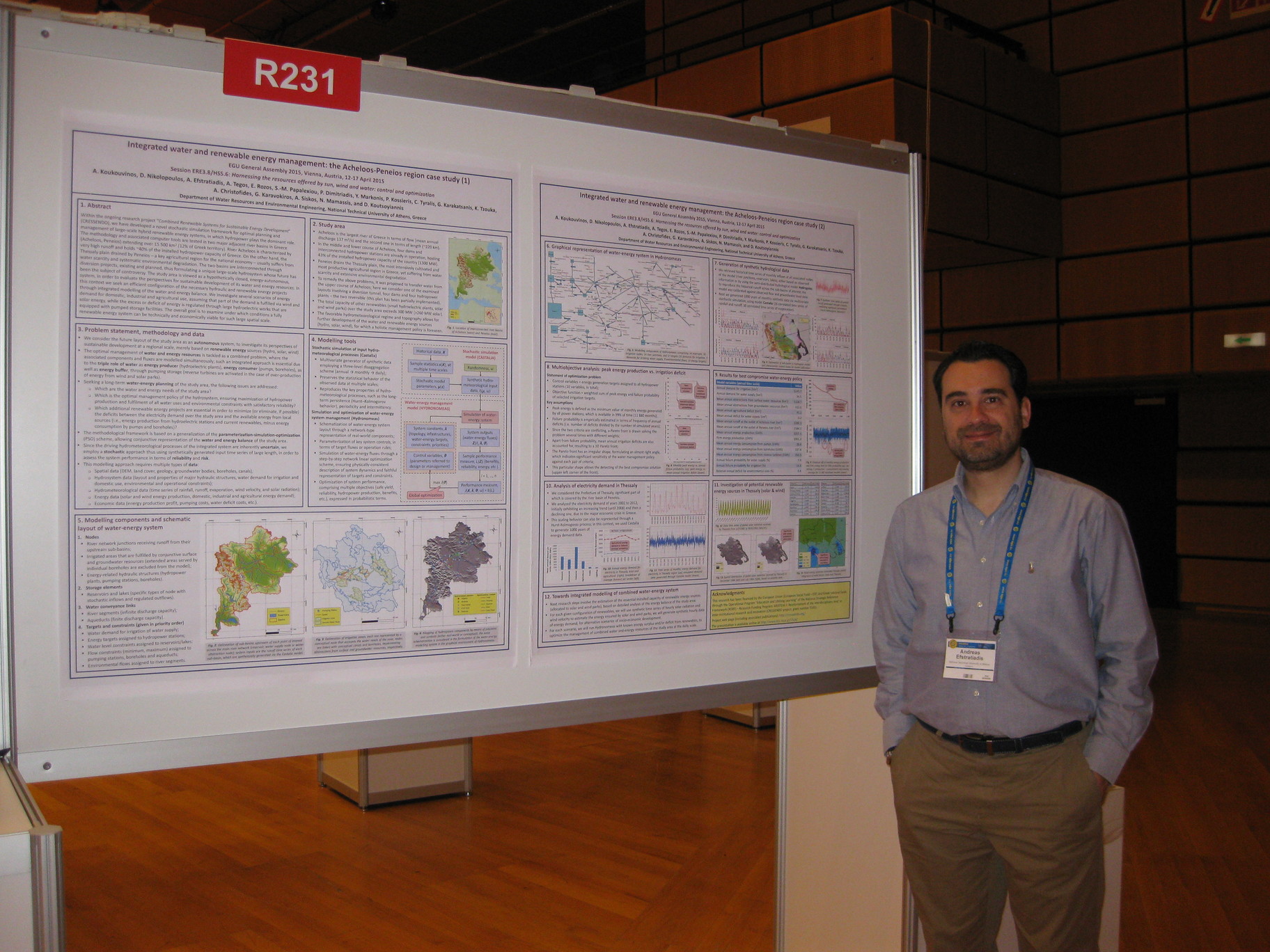
A. Koukouvinos, D. Nikolopoulos, A. Efstratiadis, A. Tegos, E. Rozos, S.M. Papalexiou, P. Dimitriadis, Y. Markonis, P. Kossieris, H. Tyralis, G. Karakatsanis, K. Tzouka, A. Christofides, G. Karavokiros, A. Siskos, N. Mamassis, and D. Koutsoyiannis, Integrated water and renewable energy management: the Acheloos-Peneios region case study, European Geosciences Union General Assembly 2015, Geophysical Research Abstracts, Vol. 17, Vienna, EGU2015-4912, doi:10.13140/RG.2.2.17726.69440, European Geosciences Union, 2015.
Within the ongoing research project “Combined Renewable Systems for Sustainable Energy Development” (CRESSENDO), we have developed a novel stochastic simulation framework for optimal planning and management of large-scale hybrid renewable energy systems, in which hydropower plays the dominant role. The methodology and associated computer tools are tested in two major adjacent river basins in Greece (Acheloos, Peneios) extending over 15 500 km2 (12% of Greek territory). River Acheloos is characterized by very high runoff and holds ~40% of the installed hydropower capacity of Greece. On the other hand, the Thessaly plain drained by Peneios – a key agricultural region for the national economy – usually suffers from water scarcity and systematic environmental degradation. The two basins are interconnected through diversion projects, existing and planned, thus formulating a unique large-scale hydrosystem whose future has been the subject of a great controversy. The study area is viewed as a hypothetically closed, energy-autonomous, system, in order to evaluate the perspectives for sustainable development of its water and energy resources. In this context we seek an efficient configuration of the necessary hydraulic and renewable energy projects through integrated modelling of the water and energy balance. We investigate several scenarios of energy demand for domestic, industrial and agricultural use, assuming that part of the demand is fulfilled via wind and solar energy, while the excess or deficit of energy is regulated through large hydroelectric works that are equipped with pumping storage facilities. The overall goal is to examine under which conditions a fully renewable energy system can be technically and economically viable for such large spatial scale.
Full text:
Additional material:
See also: http://dx.doi.org/10.13140/RG.2.2.17726.69440
Other works that reference this work (this list might be obsolete):
| 1. | Stamou, A. T., and P. Rutschmann, Pareto optimization of water resources using the nexus approach, Water Resources Management, 32, 5053-5065, doi:10.1007/s11269-018-2127-x, 2018. |
| 2. | Stamou, A.-T., and P. Rutschmann, Optimization of water use based on the water-energy-food nexus concept: Application to the long-term development scenario of the Upper Blue Nile River, Water Utility Journal, 25, 1-13, 2020. |
I. Koukas, V. Koukoravas, K. Mantesi, K. Sakellari, T.-D. Xanthopoulou, A. Zarkadoulas, Y. Markonis, S.M. Papalexiou, and D. Koutsoyiannis, Statistical properties and Hurst-Kolmogorov dynamics in climatic proxy data and temperature reconstructions, European Geosciences Union General Assembly 2014, Geophysical Research Abstracts, Vol. 16, Vienna, EGU2014-9290-2, doi:10.13140/RG.2.2.21134.56644, European Geosciences Union, 2014.
The statistical properties of over 300 different proxy records of the last two thousand years derived from the PAGES 2k database years are stochastically analysed. Analyses include estimation of their first four moments and their autocorrelation functions (ACF), as well as the determination of the presence of Hurst-Kolmogorov behaviour (known also as long term persistence). The data are investigated in groups according to their proxy type and location, while their statistical properties are also compared to those of the final temperature reconstructions.
Full text:
Additional material:
Y. Dimakos, E. C. Moschou, S. C. Batelis, Y. Markonis, and D. Koutsoyiannis, Monthly rainfall trends in Greece (1950 - 2012), European Geosciences Union General Assembly 2014, Geophysical Research Abstracts, Vol. 16, Vienna, EGU2014-8289, doi:10.13140/RG.2.2.14594.07367, European Geosciences Union, 2014.
Trends in monthly rainfall during the period from 1950 to 2012 and the variability thereof in space and time are investigated. The time series analysed are from 120 stations and cover mainly the continental part of Greece. To estimate their trends, linear regression is used for each time series separately for: (a) the entire record length (1950 – 2012) and (b) for each half of the period (1950 – 1981 and 1982 – 2012). A spatially aggregated time series of rainfall over Greece is also produced and its correlations with climatic features of the northern hemisphere are explored.
Full text: http://www.itia.ntua.gr/en/getfile/1477/1/documents/Rainfall_EGU2014_po.pdf (1880 KB)
Additional material:
E. C. Moschou, S. C. Batelis, Y. Dimakos, I. Fountoulakis, Y. Markonis, S.M. Papalexiou, N. Mamassis, and D. Koutsoyiannis, Spatial and temporal rainfall variability over Greece, Facets of Uncertainty: 5th EGU Leonardo Conference – Hydrofractals 2013 – STAHY 2013, Kos Island, Greece, doi:10.13140/RG.2.2.19102.95045, European Geosciences Union, International Association of Hydrological Sciences, International Union of Geodesy and Geophysics, 2013.
The main objective of this study is to determine the major statistical properties of rainfall over Greece and analyse their variability through time. To this end, the following properties of rainfall variability were investigated on time series extracted from Hellenic National Meteorological Service records that date back to 1950: (1) the spatial correlation among the stations and the existence of regions which demonstrate homogeneity; (2) the temporal occurrence of maximum rainfall (the month which the daily maximum occurs) and the ratio of the daily maximum to the annual sum; (3) the spatial distribution of the daily maxima, which are observed in a number of stations simultaneously, as well as the rank correlation in space of annual rainfall; (4) the classification of the empirical distributions of daily maxima. The results of our analysis offer an improved overall picture of rainfall variability over Greece and help us clarify whether some attributes have changed over the last 60 years.
Full text: http://www.itia.ntua.gr/en/getfile/1392/1/documents/Kos_RainVariability_poster.pdf (1640 KB)
N. Bountas, N. Boboti, E. Feloni, L. Zeikos, Y. Markonis, A. Tegos, N. Mamassis, and D. Koutsoyiannis, Temperature variability over Greece: Links between space and time, Facets of Uncertainty: 5th EGU Leonardo Conference – Hydrofractals 2013 – STAHY 2013, Kos Island, Greece, doi:10.13140/RG.2.2.17739.80164, European Geosciences Union, International Association of Hydrological Sciences, International Union of Geodesy and Geophysics, 2013.
Temperature is strongly linked to the hydrological cycle in numerous ways and mainly with the evapotranspiration. Our aim here is to examine the possible influence of spatial characteristics on the temperature temporal variability of the monthly absolute maxima/minima and the monthly means over Greece. To achieve this, the temperature records of the Hellenic National Meteorological Service station network, which date back to 1950, are analysed. The analysis involved two steps: the determination of regions with similar climatic properties and the investigation of the possible correlations of temperature in time. Thus, the time series are classified in three groups based on their location (continental, coastal and island) and four types regarding the proximity of the station to a city (at the city centre, near the city border, far away from city border) or to an airport. Each one of the time series is then examined for (a) the influence of the city heat island as Greek cities expanded in time, (b) the effect of the general atmospheric circulation (NAO phase), (c) its correlation to the global temperature record and (d) the implied change on evapotranspiration in the area.
Full text: http://www.itia.ntua.gr/en/getfile/1391/1/documents/Kos_Temperature_poster_.pdf (2010 KB)
Y. Markonis, A. Efstratiadis, A. Koukouvinos, N. Mamassis, and D. Koutsoyiannis, Investigation of drought characteristics in different temporal and spatial scales: A case study in the Mediterranean region , Facets of Uncertainty: 5th EGU Leonardo Conference – Hydrofractals 2013 – STAHY 2013, Kos Island, Greece, European Geosciences Union, International Association of Hydrological Sciences, International Union of Geodesy and Geophysics, 2013.
In 1988-1995 Greece experienced a drought, one of the most extended (both in space and time) and intense since the beginning of hydro-meteorological instrumental measurements. The aim of this study is to describe the phenomenon in different temporal and spatial scales in order to (a) identify possible links with Mediterranean/global climatic regime and (b) to demonstrate the role of the marginal distribution and the autocorrelation function in estimating the return period of the drought and its impact. Three spatial scales were examined: the local scale (regions of Peloponnese in the southern and Macedonia in the northern part of Greece; ~2x2° each), the national scale (~8x8°) and the Mediterranean scale (~15x45°). In the time domain the monthly, annual and inter-annual time steps were taken, while the time horizon is that of the instrumental record as well as a broader time window obtained by introducing qualitative evidence from paleoclimatic studies. Our findings show both strong temporal variability and spatial heterogeneity, which imply enhanced uncertainty.
Full text: http://www.itia.ntua.gr/en/getfile/1390/1/documents/KosDroughtPoster.pdf (661 KB)
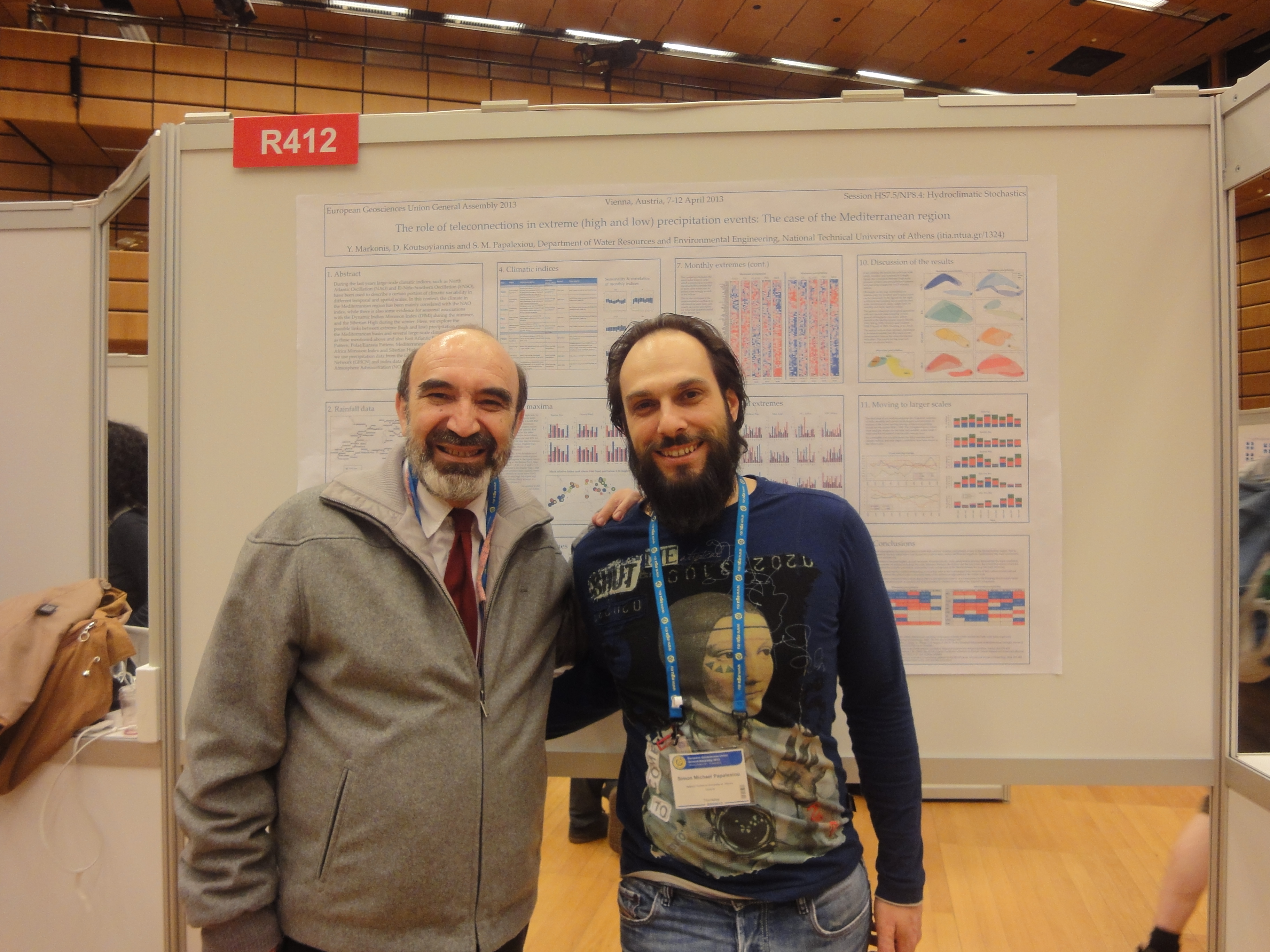
Y. Markonis, S.M. Papalexiou, and D. Koutsoyiannis, The role of teleconnections in extreme (high and low) precipitation events: The case of the Mediterranean region, European Geosciences Union General Assembly 2013, Geophysical Research Abstracts, Vol. 15, Vienna, EGU2013-5368, doi:10.13140/RG.2.2.10642.25286, European Geosciences Union, 2013.
During the last years large-scale climatic indices, such as North Atlantic Oscillation (NAO) and El-Niño Southern Oscillation (ENSO), have been used to describe a certain portion of climatic variability in different temporal and spatial scales. In this context, the climate in the Mediterranean region has been mainly correlated with the NAO index, while there is also some evidence for seasonal associations with the South Asian Monsoon (SAM) during the summer, and the Siberian High during the winter. Here, we explore the possible links between extreme (high and low) precipitation events in the Mediterranean basin and several large-scale climatic indices, such as these mentioned above and also East Atlantic Pattern, Scandinavia Pattern, Polar/Eurasia Pattern, West Africa Monsoon Index and Siberian High. In order to achieve that, we use precipitation data from the Global Historical Climatology Network (GHCN) and index data from National Oceanic and Atmosphere Administration (NOAA).
Full text:
Additional material:
P. Dimitriadis, D. Koutsoyiannis, and Y. Markonis, Spectrum vs Climacogram, European Geosciences Union General Assembly 2012, Geophysical Research Abstracts, Vol. 14, Vienna, EGU2012-993, doi:10.13140/RG.2.2.27838.89920, European Geosciences Union, 2012.
Two common stochastic tools, the spectrum and the climacogram are compared. Using time series from (a) a couple of simple harmonic functions, (b) synthetic data generated using a complex stochastic model, (c) a large-scale paleoclimatic reconstructions and (d) laboratory-scale measurements of turbulent velocity, we estimate the spectra (using fast Fourier transform) and climacograms. Both original and smooth versions of the spectra are used. The spectrum and the climacogram tools are compared to each other giving emphasis to each advantages and disadvantages and also, some questions regarding the interpretation and inference from the above methods, are discussed.
Full text:
Y. Markonis, P. Kossieris, A. Lykou, and D. Koutsoyiannis, Effects of Medieval Warm Period and Little Ice Age on the hydrology of Mediterranean region, European Geosciences Union General Assembly 2012, Geophysical Research Abstracts, Vol. 14, Vienna, 12181, doi:10.13140/RG.2.2.30565.19683, European Geosciences Union, 2012.
Medieval Warm Period (950 – 1250) and Little Ice Age (1450 – 1850) are the most recent periods that reflect the magnitude of natural climate variability. As their names suggest, the first one was characterized by higher temperatures and a generally moister climate, while the opposite happened during the second period. Although their existence is well documented for Northern Europe and North America, recent findings suggest strong evidence in lower latitudes as well. Here we analyze qualitatively the influence of these climatic fluctuations on the hydro-logical cycle all over the Mediterranean basin, highlighting the spatial characteristics of precipitation and runoff. We use both qualitative estimates from literature review in the field of paleoclimatology and statistical analysis of proxy data series. We investigate possible regional patterns and possible tele-connections with large scale atmospheric circulation phenomena such as North Atlantic Oscillation, Siberian High, African Sahel Rainfall and Indian Monsoon.
Full text:
Y. Markonis, and D. Koutsoyiannis, Hurst-Kolmogorov dynamics in long climatic proxy records, European Geosciences Union General Assembly 2011, Geophysical Research Abstracts, Vol. 13, Vienna, EGU2011-13700, doi:10.13140/RG.2.2.23080.98565, European Geosciences Union, 2011.
Orbital climate theory states that the variations in insolation caused by changes in the shape of the earth’s orbit (eccentricity of ellipse), tilt of the earth’s axis (obliquity) and precession of the equinoxes are linked with large-scale climate variations. However, there is an on-going debate about the qualitative characteristics that describe the driving force of large scale climate dynamics (linear vs. nonlinear, insolation vs. obliquity forcing), that extends to a greater disagreement about the overall appropriateness of deterministic or stochastic descriptions of glacial cycles. Through this scientific discussion some concepts are widely used by all sides, including threshold mechanisms, state transition and multi-scale fluctuations, which are characteristics that can be associated with a power-law stochastic dependence. Hurst-Kolmogorov (HK) dynamics is a characteristic model that results in power-law dependence. Here we show that HK dynamics combined with components of orbital forcing is consistent with several proxy climatic time series spanning periods up to 500 million years before present.
Full text:
A. Christofides, S. Kozanis, G. Karavokiros, Y. Markonis, and A. Efstratiadis, Enhydris: A free database system for the storage and management of hydrological and meteorological data, European Geosciences Union General Assembly 2011, Geophysical Research Abstracts, Vol. 13, Vienna, 8760, European Geosciences Union, 2011.
Enhydris is a database system for the storage and management of hydrological and meteorological data. It allows the storage and retrieval of raw data, processed time series, model parameters, curves and meta-information such as measurement stations overseers, instruments, events etc. The database is accessible through a web interface, which includes several data representation features such as tables, graphs and mapping capabilities. Data access is configurable to allow or to restrict user groups and/or privileged users to contribute or to download data. With these capabilities, Enhydris can be used either as a public repository of free data or as a fully secured – restricted system for data storage. Time series can be downloaded in plain text format that can be directly loaded to Hydrognomon (http://hydrognomon.org/), a free tool for analysis and processing of meteorological time series. Enhydris can optionally work in a distributed way. Many organisations can install one instance each, but an additional instance, common to all organisations, can be setup as a common portal. This additional instance can be configured to replicate data from the other databases, but without the space consuming time series, which it retrieves from the other databases on demand. A user can transparently use this portal to access the data of all participating organisations collectively. Enhydris is free software, available under the terms of the GNU General Public License version 3. It is developed with Python, Django, and C. Its modular design allows adding new features through the development of small applications. Enhydris is hosted by the Openmeteo project (http://openmeteo.org/), which aims to provide free tools and data.
Full text:
Other works that reference this work (this list might be obsolete):
| 1. | #Papathanasiou C., C. Makropoulos, E. Baltas, and M. Mimikou, The Hydrological Observatory of Athens: A state-of-the-art network for the assessment of the hydrometeorological regime of Attica, Proceedings of the 13th International Conference on Environmental Science and Technology, Athens, 2013. |
| 2. | #Makropoulos, C., P. Kossieris, S. Kozanis, E. Katsiri, and L. Vamvakeridou-Lyroudia, From smart meters to smart decisions: Web-based support for the water efficient household, Proceedings of 11th International Conference on Hydroinformatics (HIC 2014), New York City, 2014. |
| 3. | #Makropoulos, C., Thinking platforms for smarter urban water systems: Fusing technical and socio-economic models and tools. In: Riddick, A.T., Kessler, H., and Giles, J. R. A. (eds.), Integrated Environmental Modelling to Solve Real World Problems: Methods, Vision and Challenges, Geological Society, London, Special Publications, 408, 2014. |
| 4. | Vantas, K., hydroscoper: R interface to the Greek National Data Bank for Hydrological and Meteorological Information, Journal of Open Source Software, 3(23), 625, doi:10.21105/joss.0062, 2018. |
| 5. | Athanasiou, T., D. Salmas, P. Karvelis, I. Angelis, V. Andrea, P. Schismenos, M. Styliou, and C. Stylios, A web-geographical information system for real time monitoring of Arachthos River, Greece, IFAC PapersOnLine, 51(30), 384-389, doi:10.1016/j.ifacol.2018.11.335, 2018. |
| 6. | #Karvelis, P., D. Salmas, and C. Stylios, Monitoring real time the Arachthos River (Greece) using a web GIS platform, 2020 International Conference on Information Technologies (InfoTech), Varna, Bulgaria, 1-5, doi:10.1109/InfoTech49733.2020.9211016, 2020. |
Y. Markonis, D. Koutsoyiannis, and N. Mamassis, Orbital climate theory and Hurst-Kolmogorov dynamics, 11th International Meeting on Statistical Climatology, Edinburgh, doi:10.13140/RG.2.2.31312.30724, International Meetings on Statistical Climatology, University of Edinburgh, 2010.
Orbital climate theory, based mainly on the work of Milankovitch, is used to explain some features of long-term climate variability, especially those concerning the ice-sheet extent. The paleoclimatic time series, which describe the climate-orbital variability relationship, exhibit Hurst-Kolmogorov dynamics, also known as long-term persistence. This stochastic dynamics provides an appropriate framework to explore the reliability of statistical inferences, based on such time series, about the consistency of suggestions of the modern orbital theory. Our analysis tries to shed light on some doubts raised from the contradictions between the orbital climate theory and paleoclimatic data.
Full text:
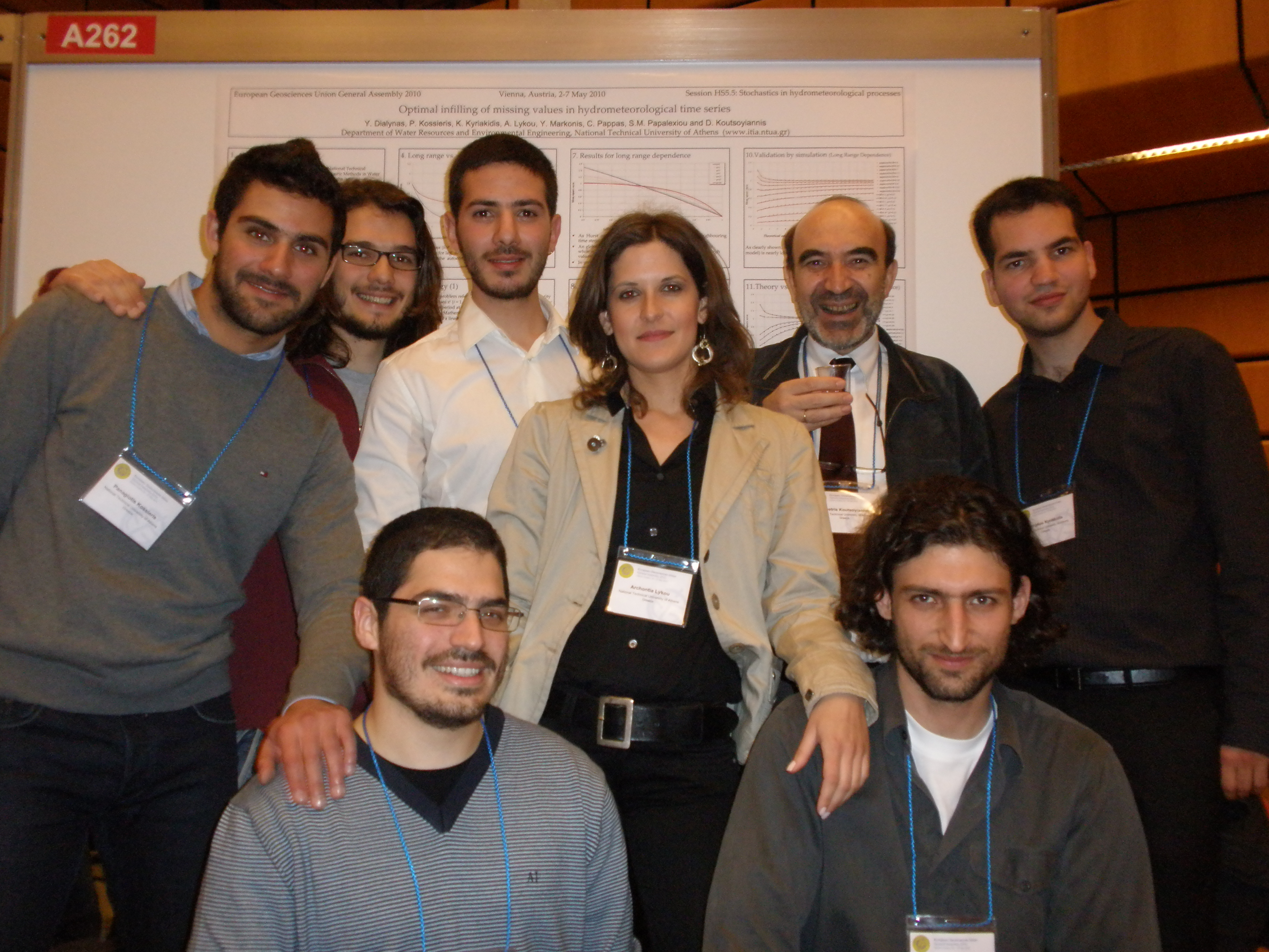
Y. Dialynas, P. Kossieris, K. Kyriakidis, A. Lykou, Y. Markonis, C. Pappas, S.M. Papalexiou, and D. Koutsoyiannis, Optimal infilling of missing values in hydrometeorological time series, European Geosciences Union General Assembly 2010, Geophysical Research Abstracts, Vol. 12, Vienna, EGU2010-9702, doi:10.13140/RG.2.2.23762.56005, European Geosciences Union, 2010.
Being a group of undergraduate students in the National Technical University of Athens, attending the course of Stochastic Methods in Water Resources, we study, in cooperation with our tutors, the infilling of missing values of hydrometeorological time series from measurements at neighbouring times. The literature provides a plethora of methods, most of which are reduced to a linear statistical interpolating relationship. Assuming that the underlying hydrometeorological process behaves like either a Markovian or a Hurst-Kolmogorov process we estimate the missing values using two techniques, i.e., (a) a local average (with equal weights) based on the optimal number of measurements referring to a number of forward and backward time steps, and (b) a weighted average using all available data. In each of the cases we determine the unknown quantities (the required number of neighbouring values or the sequence of weights) so as to minimize the estimation mean square error. The results of this investigation are easily applicable for infilling time series in real-world applications.
Full text:
Additional material:
See also: http://dx.doi.org/10.13140/RG.2.2.23762.56005
Other works that reference this work (this list might be obsolete):
| 1. | #Rianna, M., E. Ridolfi, L. Lorino, L. Alfonso, V. Montesarchio, G. Di Baldassarre, F. Russo and F. Napolitano, Definition of homogeneous regions through entropy theory, 3rd STAHY International Workshop on Statistical Methods for Hydrology and Water Resources Management, Tunis, Tunisia, 2012. |
Y. Markonis, and D. Koutsoyiannis, Hurst-Kolmogorov dynamics in paleoclimate reconstructions, European Geosciences Union General Assembly 2010, Geophysical Research Abstracts, Vol. 12, Vienna, EGU2010-14816, doi:10.13140/RG.2.2.36555.18724, European Geosciences Union, 2010.
Our understanding of the climate system is linked to our knowledge of past climate, mainly due to the role played by the variability of climate on long scales in shaping our perception of the climate system behaviour. Therefore, paleoclimate data are an important source of information, whose study should be accompanied by that of the related uncertainties, determined by an appropriate statistical framework. The Hurst-Kolmogorov dynamics, also known as long-term persistence, has been detected in many long hydroclimatic time series and is stochastically equivalent to a simple scaling behaviour of climate variability over time scale.We demonstrate that this behaviour is dominant in paleoclimate reconstructions of Pleistocene and Pliocene (0.01 – 5 million years) and has a serious impact on the estimation of uncertainty. The comparison between the classical statistical framework and the Hurst-Kolmogorov approach results in significant differences, particularly in the implied uncertainty.
Full text:
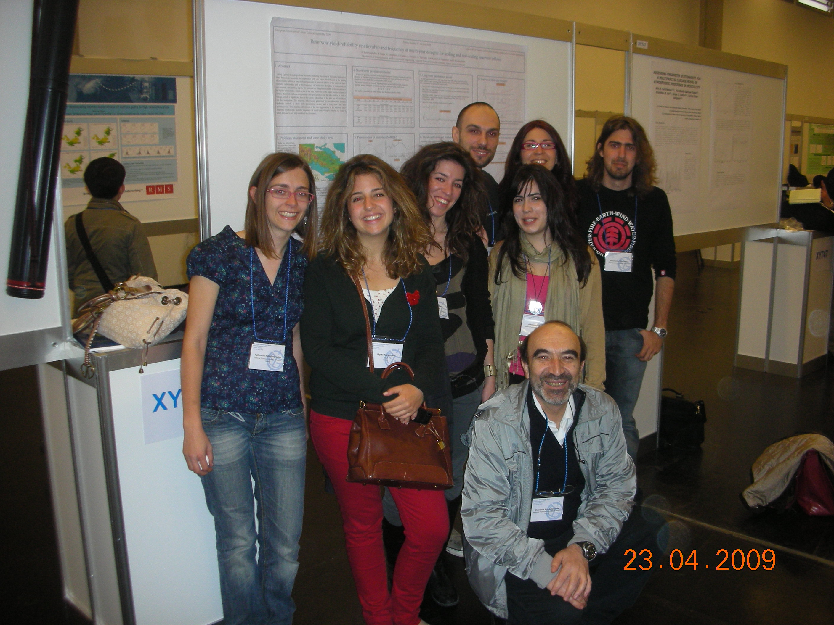
A. Katerinopoulou, K. Kagia, M. Karapiperi, A. Kassela, A. Paschalis, G.-M. Tsarouchi, Y. Markonis, S.M. Papalexiou, and D. Koutsoyiannis, Reservoir yield-reliability relationship and frequency of multi-year droughts for scaling and non-scaling reservoir inflows, European Geosciences Union General Assembly 2009, Geophysical Research Abstracts, Vol. 11, Vienna, 8063, doi:10.13140/RG.2.2.12542.79682, European Geosciences Union, 2009.
Being a group of undergraduate students attending the course of Stochastic Methods inWater Resources, we study, in cooperation with our tutors, the influence of the scaling behaviour (also known as long-term persistence) of reservoir inflows to the reservoir yield-reliability relationship and to the frequency of multi-year droughts, in comparison to conventional, non-scaling, inputs. We perform an integrated monthly-scale simulation of the Hylike natural lake, which is one of the four reservoirs of the water resource system of Athens. Reservoir inflows, evaporation and precipitation on the lake surface, as well as leakage, which is significant due to the karstic subsurface of the lake, are all considered into the simulation. The reservoir inflows are generated by two alternative monthly stochastic models, a short term persistence model and a long term one, both cyclostationary. The resulting differences of the two approaches in the reservoir yield-reliability relationship and the frequency of multi-year drought periods (i.e. those in which demand is not fully satisfied) are discussed.
Full text:
Additional material:
See also: http://meetingorganizer.copernicus.org/EGU2009/poster_programme/816
A. Efstratiadis, N. Mamassis, Y. Markonis, P. Kossieris, and H. Tyralis, Methodological framework for optimal planning and management of water and renewable energy resources, Combined REnewable Systems for Sustainable ENergy DevelOpment (CRESSENDO), 154 pages, Department of Water Resources and Environmental Engineering – National Technical University of Athens, April 2015.
We describe a stochastic simulation and optimization framework for hybrid renewable energy systems, based on effective coupling of different models. Initially, we explain the problem of combined management of water and energy resources, we introduce the main concepts and highlight the peculiarities of the problem, by means of methodology and computational implementation. Next is presented the general context, which is based on the combined use of an hourly simulation model for the renewables of a specific study area (wind and solar units), and a daily simulation model for the water resource system and the associated energy components. The models are fed by synthetic time series of hydrological inflows, wind velocity, solar radiation and electricity demand over the study area, for the generation of which are used appropriate stochastic schemes. The theoretical background of all models and related software systems is based on original methodologies or existing approaches that have been improved or generalized in the context of the research project.
Related project: Combined REnewable Systems for Sustainable ENergy DevelOpment (CRESSENDO)
Full text: http://www.itia.ntua.gr/en/getfile/1599/1/documents/Report_EE2.pdf (3766 KB)
D. Koutsoyiannis, S.M. Papalexiou, Y. Markonis, P. Dimitriadis, and P. Kossieris, Stochastic framework for uncertainty assessment of hydrometeorological procesess, Combined REnewable Systems for Sustainable ENergy DevelOpment (CRESSENDO), 231 pages, Department of Water Resources and Environmental Engineering – National Technical University of Athens, January 2015.
Related project: Combined REnewable Systems for Sustainable ENergy DevelOpment (CRESSENDO)
Full text: http://www.itia.ntua.gr/en/getfile/1589/1/documents/Report_EE1.pdf (14753 KB)
Y. Markonis, S. Lykoudis, A. Efstratiadis, and A. Koukouvinos, Description of rainfall and meteorological data and processing, DEUCALION – Assessment of flood flows in Greece under conditions of hydroclimatic variability: Development of physically-established conceptual-probabilistic framework and computational tools, Contractors: ETME: Peppas & Collaborators, Grafeio Mahera, Department of Water Resources and Environmental Engineering – National Technical University of Athens, National Observatory of Athens, 54 pages, September 2014.
Objective of this report is the analysis of rainfall and meteorological data that are gathered from the pilot basins and the description of their processing for the generation of the essential time series. The time series that are derived through processing of real-time raw data from the monitoring network are: (a) point time series of rainfall and other meteorological variables (temperature, relative humidity, wind velocity), and (b) time series of areal rainfall and potential evapotranspiration across all sub-basins of interest. Point rainfall depths from rain gauges are used for the generation of areal time series as well as the analysis of intense storm events. The extraction of areal rainfall across each basin or sub-basin of interest was done through typical techniques of spatial integration (Thiessen polygons), while the potential evapotranspiration data were indirectly estimated, as function of temperature.
Full text: http://www.itia.ntua.gr/en/getfile/1496/1/documents/Report_2_2.pdf (3082 KB)
S. Kozanis, and Y. Markonis, Hydrognomon version 4 - User manual, 141 pages, Athens, 25 November 2009.
User manual for the fourth version of Hydrognomon software. Visit the webpage of the software for more information and / or download the scientific documentation.
Full text: http://www.itia.ntua.gr/en/getfile/934/1/documents/HydrognomonV4ManualGR-v1.00.pdf (9473 KB)
See also: http://www.hydrognomon.org/
A. Efstratiadis, A. Koukouvinos, N. Mamassis, S. Baki, Y. Markonis, and D. Koutsoyiannis, [No English title available], , Commissioner: Ministry of Environment, Energy and Climate Change, Contractor: Exarhou Nikolopoulos Bensasson, 205 pages, February 2013.
A. Koukouvinos, A. Efstratiadis, N. Mamassis, Y. Markonis, S. Baki, and D. Koutsoyiannis, [No English title available], , Commissioner: Ministry of Environment, Energy and Climate Change, Contractor: Exarhou Nikolopoulos Bensasson, 144 pages, February 2013.
D. Koutsoyiannis, Y. Markonis, A. Koukouvinos, S.M. Papalexiou, N. Mamassis, and P. Dimitriadis, Hydrological study of severe rainfall in the Kephisos basin, Greece, Study of the management of Kephisos , Commissioner: General Secretariat of Public Works – Ministry of Environment, Planning and Public Works, Contractors: Exarhou Nikolopoulos Bensasson, Denco, G. Karavokiris, et al., 154 pages, Athens, 2010.
Related project: Study of the management of Kephisos
Full text: http://www.itia.ntua.gr/en/getfile/970/1/documents/2010AthensOmbrian__.pdf (6638 KB)
D. Koutsoyiannis, and Y. Markonis, Hydrological study of the Xerias Basina, Magnesia, Greece, Study of urgent flood protection works of the Xerias, Seskouliotis and Kakaviotis streams, Commissioner: Prefectural Government of Magnesia, Contractor: Grafeio Mahera, Athens, 2010.
Related project: Study of urgent flood protection works of the Xerias, Seskouliotis and Kakaviotis streams
Full text: http://www.itia.ntua.gr/en/getfile/966/1/documents/Xhrias_flood_final5.pdf (1688 KB)
D. Koutsoyiannis, Y. Markonis, A. Koukouvinos, and N. Mamassis, Hydrological study of Arachthos floods, Delineation of the Arachthos River bed in the town of Arta, Commissioner: Municipality of Arta, Contractors: ADK - Aronis Drettas Karlaftis Consulting Engineers, YDROTEK, V. Mouzos, 272 pages, 2010.
Related project: Delineation of the Arachthos River bed in the town of Arta
Full text: http://www.itia.ntua.gr/en/getfile/950/1/documents/2010Arachthos_floods.pdf (3770 KB)