Antonios Koukouvinos
Surveying Engineer
A.Koukouvinos@itia.ntua.gr
+30-2107722846
Participation in research projects
Participation as Researcher
- DEUCALION – Assessment of flood flows in Greece under conditions of hydroclimatic variability: Development of physically-established conceptual-probabilistic framework and computational tools
- Maintenance, upgrading and extension of the Decision Support System for the management of the Athens water resource system
- Development of Database and software applications in a web platform for the "National Databank for Hydrological and Meteorological Information"
- Cost of raw water of the water supply of Athens
- Development of a Geographical Information System and an Internet application for the supervision of Kephisos protected areas
- Flood risk estimation and forecast using hydrological models and probabilistic methods
- Support on the compilation of the national programme for water resources management and preservation
- Investigation of management scenarios for the Smokovo reservoir
- Integrated Management of Hydrosystems in Conjunction with an Advanced Information System (ODYSSEUS)
- Classification of quantitative and qualitative parameters of the water resources of Greece - Phases 1 and 2
- Investigation of scenarios for the management and protection of the quality of the Plastiras Lake
- Evaluation of Management of the Water Resources of Sterea Hellas - Phase 3
- Classification of quantitative and qualitative parameters of the water resources of Greece using geographical information systems
Participation in engineering studies
- Consultancy Services for Conceptual Design, Preparation of Bidding Documents, Assistance during the Selection of Contractor & Monitoring/Supervision of Construction, Instalation, Operation & Maintainance for Traffic Control (CTC) for Greater Gaborone City
- Έργα Ορεινής Υδρονομίας Ρεμάτων Ορεινών Λεκανών Απορροής Αλμωπίας
- Pleriminary study of Almopaios dam
- Study of the management of Kephisos
- Delineation of the Arachthos River bed in the town of Arta
- Μελέτες Διερεύνησης Προβλημάτων Άρδευσης και Δυνατότητας Κατασκευής Ταμιευτήρων Νομού Βοιωτίας
Published work
Publications in scientific journals
- G.-F. Sargentis, T. Iliopoulou, R. Ioannidis, M. Kougia, I. Benekos, P. Dimitriadis, A. Koukouvinos, D. Dimitrakopoulou, N. Mamassis, A. Tsouni, S. Sigourou, V. Pagana, C. Kontoes, and D. Koutsoyiannis, Technological Advances in Flood Risk Assessment and Related Operational Practices Since the 1970s: A Case Study in the Pikrodafni River of Attica, Water, 17(1) (112), doi:10.3390/w17010112, 2025.
- T. Iliopoulou, D. Koutsoyiannis, N. Malamos, A. Koukouvinos, P. Dimitriadis, N. Mamassis, N. Tepetidis, and D. Markantonis, A stochastic framework for rainfall intensity–time scale–return period relationships. Part ΙΙ: point modelling and regionalization over Greece, Hydrological Sciences Journal, 69 (8), 1092–1112, doi:10.1080/02626667.2024.2345814, 2024.
- D. Koutsoyiannis, T. Iliopoulou, A. Koukouvinos, and N. Malamos, A stochastic framework for rainfall intensity–time scale–return period relationships. Part I: theory and estimation strategies, Hydrological Sciences Journal, 69 (8), 1082–1091, doi:10.1080/02626667.2024.2345813, 2024.
- E. Dimitriou, A. Efstratiadis, I. Zotou, A. Papadopoulos, T. Iliopoulou, G.-K. Sakki, K. Mazi, E. Rozos, A. Koukouvinos, A. D. Koussis, N. Mamassis, and D. Koutsoyiannis, Post-analysis of Daniel extreme flood event in Thessaly, Central Greece: Practical lessons and the value of state-of-the-art water monitoring networks, Water, 16 (7), 980, doi:10.3390/w16070980, 2024.
- D. Koutsoyiannis, T. Iliopoulou, A. Koukouvinos, N. Malamos, N. Mamassis, P. Dimitriadis, N. Tepetidis, and D. Markantonis, In search of climate crisis in Greece using hydrological data: 404 Not Found, Water, 15 (9), 1711, doi:10.3390/w15091711, 2023.
- N. Mamassis, K. Mazi, E. Dimitriou, D. Kalogeras, N. Malamos, S. Lykoudis, A. Koukouvinos, I. L. Tsirogiannis, I. Papageorgaki, A. Papadopoulos, Y. Panagopoulos, D. Koutsoyiannis, A. Christofides, A. Efstratiadis, G. Vitantzakis, N. Kappos, D. Katsanos, B. Psiloglou, E. Rozos, T. Kopania, I. Koletsis, and A. D. Koussis, OpenHi.net: A synergistically built, national-scale infrastructure for monitoring the surface waters of Greece, Water, 13 (19), 2779, doi:10.3390/w13192779, 2021.
- G. Papaioannou, L. Vasiliades, A. Loukas, A. Alamanos, A. Efstratiadis, A. Koukouvinos, I. Tsoukalas, and P. Kossieris, A flood inundation modelling approach for urban and rural areas in lake and large-scale river basins, Water, 13 (9), 1264, doi:10.3390/w13091264, 2021.
- G. Papaioannou, A. Efstratiadis, L. Vasiliades, A. Loukas, S.M. Papalexiou, A. Koukouvinos, I. Tsoukalas, and P. Kossieris, An operational method for Floods Directive implementation in ungauged urban areas, Hydrology, 5 (2), 24, doi:10.3390/hydrology5020024, 2018.
- E. Michailidi, S. Antoniadi, A. Koukouvinos, B. Bacchi, and A. Efstratiadis, Timing the time of concentration: shedding light on a paradox, Hydrological Sciences Journal, 63 (5), 721–740, doi:10.1080/02626667.2018.1450985, 2018.
- E. Savvidou, A. Efstratiadis, A. D. Koussis, A. Koukouvinos, and D. Skarlatos, The curve number concept as a driver for delineating hydrological response units, Water, 10 (2), 194, doi:10.3390/w10020194, 2018.
- P. Dimitriadis, A. Tegos, A. Oikonomou, V. Pagana, A. Koukouvinos, N. Mamassis, D. Koutsoyiannis, and A. Efstratiadis, Comparative evaluation of 1D and quasi-2D hydraulic models based on benchmark and real-world applications for uncertainty assessment in flood mapping, Journal of Hydrology, 534, 478–492, doi:10.1016/j.jhydrol.2016.01.020, 2016.
- A. Efstratiadis, I. Nalbantis, A. Koukouvinos, E. Rozos, and D. Koutsoyiannis, HYDROGEIOS: A semi-distributed GIS-based hydrological model for modified river basins, Hydrology and Earth System Sciences, 12, 989–1006, doi:10.5194/hess-12-989-2008, 2008.
- D. Koutsoyiannis, G. Karavokiros, A. Efstratiadis, N. Mamassis, A. Koukouvinos, and A. Christofides, A decision support system for the management of the water resource system of Athens, Physics and Chemistry of the Earth, 28 (14-15), 599–609, doi:10.1016/S1474-7065(03)00106-2, 2003.
Book chapters and fully evaluated conference publications
- G.-F. Sargentis, R. Ioannidis, M. Kougia, I. Benekos, T. Iliopoulou, P. Dimitriadis, A. Koukouvinos, D. Dimitrakopoulou, N. Mamassis, A. Tsouni, S. Sigourou, V. Pagana, E. Frangedaki, N. D. Lagaros, C. Kontoes, and D. Koutsoyiannis, The technological evolution in flood risk estimation, Proceedings of the International Conferences on Digital Technology Driven Engineering 2024, Irbid - Jordan, 225–235, Springer Nature, 2025.
- G.-F. Sargentis, R. Ioannidis, M. Kougia, I. Benekos, T. Iliopoulou, P. Dimitriadis, A. Koukouvinos, D. Dimitrakopoulou, N. Mamassis, A. Tsouni, S. Sigourou, V. Pagana, E. Frangedaki, N. D. Lagaros, C. Kontoes, and D. Koutsoyiannis, Do floods attack cities or cities invade flood plains?, Proceedings of the International Conferences on Digital Technology Driven Engineering 2024, Irbid - Jordan, 216–224, Springer Nature, 2025.
- A. Tsouni, S. Sigourou, V. Pagana, M.-X. Tsoutsos, P. Dimitriadis, G.-F. Sargentis, T. Iliopoulou, R. Ioannidis, D. Dimitrakopoulou, E. Chardavellas, M.J. Alexopoulos, A. Koukouvinos, N. Mamassis, D. Koutsoyiannis, and C. Kontoes, Multi-parameter flood risk assessment and management planning at high spatial resolution in the region of Attica, Greece, IGARSS 2024 - 2024 IEEE International Geoscience and Remote Sensing Symposium, Athens, Greece, doi:10.1109/IGARSS53475.2024.10642600, IEEE, 2024.
- A. Christofides, T. Iliopoulou, P. Dimitriadis, D. Koutsoyiannis, A. Koukouvinos, V. Soulis, G.-F. Sargentis, C. Myriounis, and A. Christoforou, Enhydris: Software for the geographic - hydrological - hydraulic visualization and data management for hydrosystems: Application on the water supply system of Athens, Proceedings of 4th Hellenic Conference on Dams and Reservoirs, War Museum Athens, 9 pages, Hellenic Commission on Large Dams, Athens, 2024.
- D. Koutsoyiannis, T. Iliopoulou, A. Koukouvinos, N. Malamos, N. Mamassis, P. Dimitriadis, N. Tepetidis, and D. Markantonis, Extreme rainfall modelling for the design of hydraulic works and dams: the new methodology and its application in Greece [Invited talk], Proceedings of 4th Hellenic Conference on Dams and Reservoirs, War Museum Athens, doi:10.13140/RG.2.2.24009.35689, Hellenic Commission on Large Dams, Athens, 2024.
- G. Papaioannou, L. Vasiliades, A. Loukas, A. Efstratiadis, S.M. Papalexiou, Y. Markonis, and A. Koukouvinos, A methodological approach for flood risk management in urban areas: The Volos city paradigm, 10th World Congress on Water Resources and Environment "Panta Rhei", Athens, European Water Resources Association, 2017.
- A. Tsouni, C. Contoes, E. Ieronymidi, A. Koukouvinos, and D. Koutsoyiannis, BEYOND Center of Excellence: flood mapping and modelling, 1st International Geomatics Applications “Geomapplica” Conference, Skiathos Island, Greece, doi:10.13140/RG.2.1.1129.7520, University of Thessaly, 2014.
- A. Efstratiadis, A. D. Koussis, S. Lykoudis, A. Koukouvinos, A. Christofides, G. Karavokiros, N. Kappos, N. Mamassis, and D. Koutsoyiannis, Hydrometeorological network for flood monitoring and modeling, Proceedings of First International Conference on Remote Sensing and Geoinformation of Environment, Paphos, Cyprus, 8795, 10-1–10-10, doi:10.1117/12.2028621, Society of Photo-Optical Instrumentation Engineers (SPIE), 2013.
- K. Hadjibiros, A. Katsiri, A. Koukouvinos, N. Moutafis, and G. Vilandou, Sustainable management of a large-scale tourist facility with significant water demand, Proceedings of the 12th International Conference on Environmental Science and Technology, A672–A679, Rhodes, 2011.
- S. Mihas, K. Nikolaou, A. Koukouvinos, and N. Mamassis, Estimation of sediment yield with MUSLE and monitoring. A case study for Tsiknias dam at Lesvos Island in Greece, IWA Balkan Young Water Professionals, Thessaloniki, 8 pages, 12 May 2015.
Conference publications and presentations with evaluation of abstract
- T. Iliopoulou, D. Koutsoyiannis, N. Malamos, A. Koukouvinos, P. Dimitriadis, N. Mamassis, N. Tepetidis, and D. Markantonis, A stochastic framework for rainfall intensity-timescale-return period relationships regionalized over Greece, European Geosciences Union General Assembly 2024, Vienna, Austria & Online, EGU24-9043, doi:10.5194/egusphere-egu24-9043, 2024.
- T. Iliopoulou, D. Koutsoyiannis, A. Koukouvinos, N. Malamos, N Tepetidis, D. Markantonis, P. Dimitriadis, and N. Mamassis, Regionalized design rainfall curves for Greece, European Geosciences Union General Assembly 2023, Vienna, Austria & Online, EGU23-8740, doi:10.5194/egusphere-egu23-8740, 2023.
- I. Papageorgaki, A. Koukouvinos, and N. Mamassis, OpenHiGis: A national geographic database for inland waters of Greece based on the INSPIRE Directive Hydrology Theme, EGU General Assembly 2021, online, doi:10.5194/egusphere-egu21-13465, European Geosciences Union, 2021.
- A. Efstratiadis, N. Mamassis, A. Koukouvinos, D. Koutsoyiannis, K. Mazi, A. D. Koussis, S. Lykoudis, E. Demetriou, N. Malamos, A. Christofides, and D. Kalogeras, Open Hydrosystem Information Network: Greece’s new research infrastructure for water, European Geosciences Union General Assembly 2020, Geophysical Research Abstracts, Vol. 22, Vienna, EGU2020-4164, doi:10.5194/egusphere-egu2020-4164, 2020.
- A. Efstratiadis, N. Mamassis, A. Koukouvinos, K. Mazi, E. Dimitriou, and D. Koutsoyiannis, Strategic plan for establishing a national-scale hydrometric network in Greece: challenges and perspectives, European Geosciences Union General Assembly 2019, Geophysical Research Abstracts, Vol. 21, Vienna, EGU2019-16714, European Geosciences Union, 2019.
- C. Ntigkakis, G. Markopoulos-Sarikas, P. Dimitriadis, T. Iliopoulou, A. Efstratiadis, A. Koukouvinos, A. D. Koussis, K. Mazi, D. Katsanos, and D. Koutsoyiannis, Hydrological investigation of the catastrophic flood event in Mandra, Western Attica, European Geosciences Union General Assembly 2018, Geophysical Research Abstracts, Vol. 20, Vienna, EGU2018-17591-1, European Geosciences Union, 2018.
- E. Michailidi, S. Antoniadi, A. Koukouvinos, B. Bacchi, and A. Efstratiadis, Velocity-based approach for establishing a varying time of concentration: Α study in three Mediterranean countries, Le Giornate dell’ Idrologia 2017, Favignana, Società Idrologica Italiana, 2017.
- E. Michailidi, S. Antoniadi, A. Koukouvinos, B. Bacchi, and A. Efstratiadis, Adaptation of the concept of varying time of concentration within flood modelling: Theoretical and empirical investigations across the Mediterranean, European Geosciences Union General Assembly 2017, Geophysical Research Abstracts, Vol. 19, Vienna, 19, EGU2017-10663-1, European Geosciences Union, 2017.
- Ο. Daskalou, M. Karanastasi, Y. Markonis, P. Dimitriadis, A. Koukouvinos, A. Efstratiadis, and D. Koutsoyiannis, GIS-based approach for optimal siting and sizing of renewables considering techno-environmental constraints and the stochastic nature of meteorological inputs, European Geosciences Union General Assembly 2016, Geophysical Research Abstracts, Vol. 18, Vienna, EGU2016-12044-1, doi:10.13140/RG.2.2.19535.48803, European Geosciences Union, 2016.
- A. Efstratiadis, S.M. Papalexiou, Y. Markonis, A. Koukouvinos, L. Vasiliades, G. Papaioannou, and A. Loukas, Flood risk assessment at the regional scale: Computational challenges and the monster of uncertainty, European Geosciences Union General Assembly 2016, Geophysical Research Abstracts, Vol. 18, Vienna, EGU2016-12218, European Geosciences Union, 2016.
- E. Rozos, D. Nikolopoulos, A. Efstratiadis, A. Koukouvinos, and C. Makropoulos, Flow based vs. demand based energy-water modelling, European Geosciences Union General Assembly 2015, Geophysical Research Abstracts, Vol. 17, Vienna, EGU2015-6528, European Geosciences Union, 2015.
- A. Koukouvinos, D. Nikolopoulos, A. Efstratiadis, A. Tegos, E. Rozos, S.M. Papalexiou, P. Dimitriadis, Y. Markonis, P. Kossieris, H. Tyralis, G. Karakatsanis, K. Tzouka, A. Christofides, G. Karavokiros, A. Siskos, N. Mamassis, and D. Koutsoyiannis, Integrated water and renewable energy management: the Acheloos-Peneios region case study, European Geosciences Union General Assembly 2015, Geophysical Research Abstracts, Vol. 17, Vienna, EGU2015-4912, doi:10.13140/RG.2.2.17726.69440, European Geosciences Union, 2015.
- A. Zarkadoulas, K. Mantesi, A. Efstratiadis, A. D. Koussis, K. Mazi, D. Katsanos, A. Koukouvinos, and D. Koutsoyiannis, A hydrometeorological forecasting approach for basins with complex flow regime, European Geosciences Union General Assembly 2015, Geophysical Research Abstracts, Vol. 17, Vienna, EGU2015-3904, doi:10.13140/RG.2.2.21920.99842, European Geosciences Union, 2015.
- T. Tsitseli, D. Koutsoyiannis, A. Koukouvinos, and N. Mamassis, Construction of ombrian curves using the Hydrognomon software system, Facets of Uncertainty: 5th EGU Leonardo Conference – Hydrofractals 2013 – STAHY 2013, Kos Island, Greece, doi:10.13140/RG.2.2.34517.01762, European Geosciences Union, International Association of Hydrological Sciences, International Union of Geodesy and Geophysics, 2013.
- Y. Markonis, A. Efstratiadis, A. Koukouvinos, N. Mamassis, and D. Koutsoyiannis, Investigation of drought characteristics in different temporal and spatial scales: A case study in the Mediterranean region , Facets of Uncertainty: 5th EGU Leonardo Conference – Hydrofractals 2013 – STAHY 2013, Kos Island, Greece, European Geosciences Union, International Association of Hydrological Sciences, International Union of Geodesy and Geophysics, 2013.
- E. Michailidi, T. Mastrotheodoros, A. Efstratiadis, A. Koukouvinos, and D. Koutsoyiannis, Flood modelling in river basins with highly variable runoff, Facets of Uncertainty: 5th EGU Leonardo Conference – Hydrofractals 2013 – STAHY 2013, Kos Island, Greece, doi:10.13140/RG.2.2.30847.00167, European Geosciences Union, International Association of Hydrological Sciences, International Union of Geodesy and Geophysics, 2013.
- A. Efstratiadis, A. Koukouvinos, P. Dimitriadis, A. Tegos, N. Mamassis, and D. Koutsoyiannis, A stochastic simulation framework for flood engineering, Facets of Uncertainty: 5th EGU Leonardo Conference – Hydrofractals 2013 – STAHY 2013, Kos Island, Greece, doi:10.13140/RG.2.2.16848.51201, European Geosciences Union, International Association of Hydrological Sciences, International Union of Geodesy and Geophysics, 2013.
- V. Pagana, A. Tegos, P. Dimitriadis, A. Koukouvinos, P. Panagopoulos, and N. Mamassis, Alternative methods in floodplain hydraulic simulation - Experiences and perspectives, European Geosciences Union General Assembly 2013, Geophysical Research Abstracts, Vol. 15, Vienna, EGU2013-10283-2, European Geosciences Union, 2013.
- A. Oikonomou, P. Dimitriadis, A. Koukouvinos, A. Tegos, V. Pagana, P. Panagopoulos, N. Mamassis, and D. Koutsoyiannis, Floodplain mapping via 1D and quasi-2D numerical models in the valley of Thessaly, Greece, European Geosciences Union General Assembly 2013, Geophysical Research Abstracts, Vol. 15, Vienna, EGU2013-10366, doi:10.13140/RG.2.2.25165.03040, European Geosciences Union, 2013.
- S. Kozanis, A. Christofides, A. Efstratiadis, A. Koukouvinos, G. Karavokiros, N. Mamassis, D. Koutsoyiannis, and D. Nikolopoulos, Using open source software for the supervision and management of the water resources system of Athens, European Geosciences Union General Assembly 2012, Geophysical Research Abstracts, Vol. 14, Vienna, 7158, doi:10.13140/RG.2.2.28468.04482, European Geosciences Union, 2012.
- A. Christofides, S. Kozanis, G. Karavokiros, and A. Koukouvinos, Enhydris, Filotis & openmeteo.org: Free software for environmental management, FLOSS Conference 2011, Athens, http://conferences.ellak.gr/2011/, 2011.
- K. Hadjibiros, N. Mamassis, A. Koukouvinos, and E. Kyritsis, Data base for the Greek nature (FILOTIS), The NTUA in the lead of research and technology , Athens, 2007.
- A. Efstratiadis, A. Koukouvinos, E. Rozos, I. Nalbantis, and D. Koutsoyiannis, Control of uncertainty in complex hydrological models via appropriate schematization, parameterization and calibration, European Geosciences Union General Assembly 2006, Geophysical Research Abstracts, Vol. 8, Vienna, 02181, doi:10.13140/RG.2.2.28297.65124, European Geosciences Union, 2006.
- A. Efstratiadis, G. Karavokiros, S. Kozanis, A. Christofides, A. Koukouvinos, E. Rozos, N. Mamassis, I. Nalbantis, K. Noutsopoulos, E. Romas, L. Kaliakatsos, A. Andreadakis, and D. Koutsoyiannis, The ODYSSEUS project: Developing an advanced software system for the analysis and management of water resource systems, European Geosciences Union General Assembly 2006, Geophysical Research Abstracts, Vol. 8, Vienna, 03910, doi:10.13140/RG.2.2.24942.20805, European Geosciences Union, 2006.
- A. Efstratiadis, A. Tegos, I. Nalbantis, E. Rozos, A. Koukouvinos, N. Mamassis, S.M. Papalexiou, and D. Koutsoyiannis, Hydrogeios, an integrated model for simulating complex hydrographic networks - A case study to West Thessaly region, 7th Plinius Conference on Mediterranean Storms, Rethymnon, Crete, doi:10.13140/RG.2.2.25781.06881, European Geosciences Union, 2005.
- A. Efstratiadis, E. Rozos, A. Koukouvinos, I. Nalbantis, G. Karavokiros, and D. Koutsoyiannis, An integrated model for conjunctive simulation of hydrological processes and water resources management in river basins, European Geosciences Union General Assembly 2005, Geophysical Research Abstracts, Vol. 7, Vienna, 03560, doi:10.13140/RG.2.2.27930.64960, European Geosciences Union, 2005.
Presentations and publications in workshops
- D. Koutsoyiannis, T. Iliopoulou, A. Koukouvinos, N. Malamos, N. Mamassis, P. Dimitriadis, N. Tepetidis, and D. Markantonis, Extreme rainfall modelling for engineering design: a new methodology and its application over the Greek territory (invited), Risk Management: Extremes of Flood and Drought, Europe/China, UNESCO, 2023.
- A. Tsouni, S. Sigourou, V. Pagana, D. Koutsoyiannis, N. Mamassis, A. Koukouvinos, P. Dimitriadis, T. Iliopoulou, G.-F. Sargentis, R. Ioannidis, D. Dimitrakopoulou, E. Chardavellas, S. Vavoulogiannis, and V. Kyriakouli, Flood risk assessment in the Pikrodafni basin, Presentation of results for the 1st Phase of the Program Agreement between Attica Regional Authority and NOA, Athens, National Observatory of Athens, 2022.
- A. Efstratiadis, N. Mamassis, A. Koukouvinos, T. Iliopoulou, S. Antoniadi, and D. Koutsoyiannis, Strategic plan for developing a National Hydrometric Network, Hellenic Integrated Marine and Inland water Observing, Forecasting and offshore Technology System (HIMIOFoTS) - Second meeting of project partners, Department of Water Resources and Environmental Engineering – National Technical University of Athens, 2019.
- N. Mamassis, A. Efstratiadis, A. Koukouvinos, and D. Koutsoyiannis, Open Hydrosystem Information Network (OpenHi.net): Evolution of works, challeneges and perspectives, Hellenic Integrated Marine and Inland water Observing, Forecasting and offshore Technology System (HIMIOFoTS) - Second meeting of project partners, Department of Water Resources and Environmental Engineering – National Technical University of Athens, 2019.
- N. Mamassis, A. Efstratiadis, D. Koutsoyiannis, and A. Koukouvinos, Open Hydrosystem Information Network (OpenHi.net), Hellenic Integrated Marine and Inland water Observing, Forecasting and offshore Technology System (HIMIOFoTS) - First meeting of project partners, Anavyssos, Hellenic Centre for Marine Research, 2018.
- Ο. Daskalou, A. Koukouvinos, A. Efstratiadis, and D. Koutsoyiannis, Methodology for optimal allocation and sizing of renewable energy sources using ArcGIS 10.3: Case study of Thessaly Perfecture, 24th Hellenic Meeting of ArcGIS Users, Crowne Plaza, Athens, Marathon Data Systems, 2016.
- A. Efstratiadis, A. Koukouvinos, N. Mamassis, and D. Koutsoyiannis, The quantitative dimension of WFD 2000/60, Water Framework Directive 2000/60 and Inland Water Protection: Research and Perspectives, Athens, Hellenic Centre for Marine Research, Specific Secreteriat of Water – Ministry of Environment, Energy and Climate Change, 2015.
- A. Koukouvinos, Proposed methodological framework of flood hydrology, Workshop - Deucalion research project, Goulandris National Histroy Museum, 2014.
- A. Tegos, A. Efstratiadis, A. Varveris, N. Mamassis, A. Koukouvinos, and D. Koutsoyiannis, Assesment and implementation of ecological flow constraints in large hydroelectric works: The case of Acheloos, Ecological flow of rivers and the importance of their true assesment, 2014.
- A. D. Koussis, S. Lykoudis, A. Efstratiadis, A. Koukouvinos, N. Mamassis, D. Koutsoyiannis, A. Peppas, and A. Maheras, Estimating flood flows in ungauged Greek basins under hydroclimatic variability (Deukalion project) - Development of physically-established conceptual-probabilistic framework and computational tools, Climate and Environmental Change in the Mediterranean Region, Pylos, Navarino Environmental Observatory, 2012.
- D. Koutsoyiannis, A. Andreadakis, R. Mavrodimou, A. Koukouvinos, and N. Mamassis, The Master Plan for the water resource management of Greece (invited talk), International Conference: Integrated Management of Coastal Areas, Faliro, doi:10.13140/RG.2.2.30398.08005, CoPraNet, Mediterranean SOS, 2006.
- D. Koutsoyiannis, A. Efstratiadis, and A. Koukouvinos, Hydrological investigation of the Plastiras lake management, Workshop for the presentation of the research project "Investigation of scenarios for the management and protection of the quality of the Plastiras Lake", doi:10.13140/RG.2.2.16950.09286, Municipality of Karditsa, Karditsa, 2002.
- E. Rozos, D. Koutsoyiannis, and A. Koukouvinos, Supervision and investigation of the boreholes of the Yliki area using geographical information system, 7th meeting of the Greek users of ArcInfo, Marathon Data Systems, 1997.
- D. Hadjichristos, D. Koutsoyiannis, and A. Koukouvinos, Investigation of the design of storm sewer networks using geographical information system, 5th meeting of the Greek users of ArcInfo, Marathon Data Systems, 1995.
Educational notes
- N. Mamassis, A. Koukouvinos, and A. Efstratiadis, Lecture notes: Geographical Information Systems for Hydrology, School of Pedagogical & Technological Education (ASPAITE), 2017.
Research reports
- D. Koutsoyiannis, T. Iliopoulou, A. Koukouvinos, N. Malamos, N. Mamassis, P. Dimitriadis, N. Tepetidis, and D. Markantonis, Technical Report, Production of maps with updated parameters of the ombrian curves at country level (implementation of the EU Directive 2007/60/EC in Greece), Department of Water Resources and Environmental Engineering – National Technical University of Athens, 2023.
- N. Mamassis, D. Koutsoyiannis, A. Efstratiadis, A. Koukouvinos, and I. Papageorgaki, Dissemination actions (papers, conferences), Open Hydrosystem Information Network (OpenHi.net), Contractor: Department of Water Resources and Environmental Engineering – National Technical University of Athens, 84 pages, October 2021.
- N. Mamassis, and A. Koukouvinos, Diaries of internal meetings, Open Hydrosystem Information Network (OpenHi.net), Contractor: Department of Water Resources and Environmental Engineering – National Technical University of Athens, 30 pages, October 2021.
- I. Papageorgaki, and A. Koukouvinos, Technical report. Organization of geographical data, Open Hydrosystem Information Network (OpenHi.net), Contractor: Department of Water Resources and Environmental Engineering – National Technical University of Athens, October 2021.
- N. Mamassis, A. Efstratiadis, A. Koukouvinos, and D. Koutsoyiannis, Technical report: Evaluation of the preliminary operation of OpenHi.net system, Open Hydrosystem Information Network (OpenHi.net), Contractor: Department of Water Resources and Environmental Engineering – National Technical University of Athens, 47 pages, October 2021.
- N. Mamassis, A. Efstratiadis, A. Koukouvinos, and D. Koutsoyiannis, Technical report: Development of a national monitoring system for surface water resources, Open Hydrosystem Information Network (OpenHi.net), Contractor: Department of Water Resources and Environmental Engineering – National Technical University of Athens, Τεύχος 2.1, June 2019.
- C. Makropoulos, A. Efstratiadis, G. Karakatsanis, D. Nikolopoulos, and A. Koukouvinos, Final raw water financial costing report, Update of financial cost of raw water for the water supply of Athens , 120 pages, Department of Water Resources and Environmental Engineering – National Technical University of Athens, May 2018.
- N. Mamassis, D. Koutsoyiannis, A. Efstratiadis, and A. Koukouvinos, Technical report: Specification analysis of OpenHi.net system, Open Hydrosystem Information Network (OpenHi.net), Contractor: Department of Water Resources and Environmental Engineering – National Technical University of Athens, 29 pages, Τεύχος 3.1, September 2018.
- C. Makropoulos, A. Efstratiadis, G. Karakatsanis, D. Nikolopoulos, and A. Koukouvinos, Calculation of financial cost of raw water - Synoptic report, Update of financial cost of raw water for the water supply of Athens , 93 pages, Department of Water Resources and Environmental Engineering – National Technical University of Athens, February 2018.
- A. Koukouvinos, A. Efstratiadis, D. Nikolopoulos, H. Tyralis, A. Tegos, N. Mamassis, and D. Koutsoyiannis, Case study in the Acheloos-Thessaly system, Combined REnewable Systems for Sustainable ENergy DevelOpment (CRESSENDO), 98 pages, Department of Water Resources and Environmental Engineering – National Technical University of Athens, October 2015.
- Y. Markonis, S. Lykoudis, A. Efstratiadis, and A. Koukouvinos, Description of rainfall and meteorological data and processing, DEUCALION – Assessment of flood flows in Greece under conditions of hydroclimatic variability: Development of physically-established conceptual-probabilistic framework and computational tools, Contractors: ETME: Peppas & Collaborators, Grafeio Mahera, Department of Water Resources and Environmental Engineering – National Technical University of Athens, National Observatory of Athens, 54 pages, September 2014.
- A. Efstratiadis, A. Koukouvinos, E. Michailidi, E. Galiouna, K. Tzouka, A. D. Koussis, N. Mamassis, and D. Koutsoyiannis, Description of regional approaches for the estimation of characteristic hydrological quantities, DEUCALION – Assessment of flood flows in Greece under conditions of hydroclimatic variability: Development of physically-established conceptual-probabilistic framework and computational tools, Contractors: ETME: Peppas & Collaborators, Grafeio Mahera, Department of Water Resources and Environmental Engineering – National Technical University of Athens, National Observatory of Athens, 146 pages, September 2014.
- A. Efstratiadis, A. Koukouvinos, P. Dimitriadis, E. Rozos, and A. D. Koussis, Theoretical documentation of hydrological-hydraulic simulation model, DEUCALION – Assessment of flood flows in Greece under conditions of hydroclimatic variability: Development of physically-established conceptual-probabilistic framework and computational tools, Contractors: ETME: Peppas & Collaborators, Grafeio Mahera, Department of Water Resources and Environmental Engineering – National Technical University of Athens, National Observatory of Athens, 108 pages, September 2014.
- A. Koukouvinos, Geographical data and procesing, DEUCALION – Assessment of flood flows in Greece under conditions of hydroclimatic variability: Development of physically-established conceptual-probabilistic framework and computational tools, Contractors: ETME: Peppas & Collaborators, Grafeio Mahera, Department of Water Resources and Environmental Engineering – National Technical University of Athens, National Observatory of Athens, 36 pages, March 2012.
- N. Mamassis, A. Efstratiadis, G. Karavokiros, S. Kozanis, and A. Koukouvinos, Final report, Maintenance, upgrading and extension of the Decision Support System for the management of the Athens water resource system, Contractors: , Report 2, 84 pages, Department of Water Resources and Environmental Engineering – National Technical University of Athens, November 2011.
- C. Makropoulos, D. Damigos, A. Efstratiadis, A. Koukouvinos, and A. Benardos, Synoptic report and final conclusions, Cost of raw water of the water supply of Athens, 32 pages, Department of Water Resources and Environmental Engineering – National Technical University of Athens, October 2010.
- C. Makropoulos, A. Efstratiadis, and A. Koukouvinos, Appraisal of financial cost and proposals for a rational management of the hydrosystem, Cost of raw water of the water supply of Athens, 73 pages, Department of Water Resources and Environmental Engineering – National Technical University of Athens, October 2010.
- C. Makropoulos, A. Koukouvinos, A. Efstratiadis, and N. Chalkias, Mehodology for estimation of the financial cost , Cost of raw water of the water supply of Athens, 40 pages, Department of Water Resources and Environmental Engineering – National Technical University of Athens, July 2010.
- A. Koukouvinos, A. Efstratiadis, and E. Rozos, Hydrogeios - Version 2.0 - User manual, Development of Database and software applications in a web platform for the "National Databank for Hydrological and Meteorological Information" , Contractor: Department of Water Resources and Environmental Engineering – National Technical University of Athens, 100 pages, November 2009.
- A. Efstratiadis, E. Rozos, and A. Koukouvinos, Hydrogeios: Hydrological and hydrogeological simulation model - Documentation report, Development of Database and software applications in a web platform for the "National Databank for Hydrological and Meteorological Information" , 139 pages, Department of Water Resources and Environmental Engineering – National Technical University of Athens, November 2009.
- N. Mamassis, A. Koukouvinos, and S. Baki, Final report, Development of a Geographical Information System and an Internet application for the supervision of Kephisos protected areas, Contractor: Department of Water Resources and Environmental Engineering – National Technical University of Athens, Athens, November 2008.
- D. Koutsoyiannis, N. Mamassis, A. Koukouvinos, and A. Efstratiadis, Summary report, Athens, Investigation of management scenarios for the Smokovo reservoir, Contractor: Department of Water Resources, Hydraulic and Maritime Engineering – National Technical University of Athens, 37 pages, Department of Water Resources and Environmental Engineering – National Technical University of Athens, August 2008.
- D. Koutsoyiannis, N. Mamassis, A. Koukouvinos, and A. Efstratiadis, Final report, Investigation of management scenarios for the Smokovo reservoir, Contractor: Department of Water Resources, Hydraulic and Maritime Engineering – National Technical University of Athens, Report 4, 66 pages, Department of Water Resources and Environmental Engineering – National Technical University of Athens, Athens, July 2008.
- A. Efstratiadis, A. Koukouvinos, N. Mamassis, and D. Koutsoyiannis, Alternative scenarios for the management and optimal operation of the Smokovo reservoir and the related works, Investigation of management scenarios for the Smokovo reservoir, Contractor: Department of Water Resources, Hydraulic and Maritime Engineering – National Technical University of Athens, Report 3, 104 pages, Department of Water Resources and Environmental Engineering – National Technical University of Athens, July 2008.
- D. Koutsoyiannis, A. Andreadakis, R. Mavrodimou, A. Christofides, N. Mamassis, A. Efstratiadis, A. Koukouvinos, G. Karavokiros, S. Kozanis, D. Mamais, and K. Noutsopoulos, National Programme for the Management and Protection of Water Resources, Support on the compilation of the national programme for water resources management and preservation, 748 pages, doi:10.13140/RG.2.2.25384.62727, Department of Water Resources and Environmental Engineering – National Technical University of Athens, Athens, February 2008.
- N. Mamassis, R. Mavrodimou, A. Efstratiadis, M. Heidarlis, A. Tegos, A. Koukouvinos, P. Lazaridou, M. Magaliou, and D. Koutsoyiannis, Investigation of alternative organisations and operations of a Water Management Body for the Smokovo projects, Investigation of management scenarios for the Smokovo reservoir, Report 2, 73 pages, Department of Water Resources, Hydraulic and Maritime Engineering – National Technical University of Athens, Athens, March 2007.
- A. Efstratiadis, A. Koukouvinos, E. Rozos, A. Tegos, and I. Nalbantis, Theoretical documentation of model for simulating hydrological-hydrogeological processes of river basin "Hydrogeios", Integrated Management of Hydrosystems in Conjunction with an Advanced Information System (ODYSSEUS), Contractor: NAMA, Report 4a, 103 pages, Department of Water Resources, Hydraulic and Maritime Engineering – National Technical University of Athens, Athens, December 2006.
- A. Koukouvinos, A. Efstratiadis, L. Lazaridis, and N. Mamassis, Data report, Investigation of management scenarios for the Smokovo reservoir, Report 1, 66 pages, Department of Water Resources, Hydraulic and Maritime Engineering – National Technical University of Athens, Athens, January 2006.
- A. Koukouvinos, Geographical information system, Modernisation of the supervision and management of the water resource system of Athens, Report 18, 39 pages, Department of Water Resources, Hydraulic and Maritime Engineering – National Technical University of Athens, Athens, January 2004.
- D. Koutsoyiannis, I. Nalbantis, G. Karavokiros, A. Efstratiadis, N. Mamassis, A. Koukouvinos, A. Christofides, E. Rozos, A. Economou, and G. M. T. Tentes, Methodology and theoretical background, Modernisation of the supervision and management of the water resource system of Athens, Report 15, Department of Water Resources, Hydraulic and Maritime Engineering – National Technical University of Athens, Athens, January 2004.
- Ministry of Development, NTUA, Institute of Geological and Mining Research, and Centre for Research and Planning, Master plan for water resource management of the country, Completion of the classification of quantitative and qualitative parameters of water resources in water districts of Greece, Contractor: Department of Water Resources, Hydraulic and Maritime Engineering – National Technical University of Athens, 549 pages, Ministry of Development, Athens, January 2003.
- D. Koutsoyiannis, A. Efstratiadis, G. Karavokiros, A. Koukouvinos, N. Mamassis, I. Nalbantis, E. Rozos, Ch. Karopoulos, A. Nassikas, E. Nestoridou, and D. Nikolopoulos, Master plan of the Athens water resource system — Year 2002–2003, Modernisation of the supervision and management of the water resource system of Athens, Report 14, 215 pages, Department of Water Resources, Hydraulic and Maritime Engineering – National Technical University of Athens, Athens, December 2002.
- A. Efstratiadis, A. Koukouvinos, D. Koutsoyiannis, and N. Mamassis, Hydrological Study, Investigation of scenarios for the management and protection of the quality of the Plastiras Lake, Report 2, 70 pages, Department of Water Resources, Hydraulic and Maritime Engineering – National Technical University of Athens, Athens, March 2002.
- K. Hadjibiros, D. Koutsoyiannis, A. Andreadakis, A. Katsiri, A. Stamou, A. Valassopoulos, A. Efstratiadis, I. Katsiris, M. Kapetanaki, A. Koukouvinos, N. Mamassis, K. Noutsopoulos, G.-F. Sargentis, and A. Christofides, Overview report, Investigation of scenarios for the management and protection of the quality of the Plastiras Lake, Report 1, 23 pages, Department of Water Resources, Hydraulic and Maritime Engineering – National Technical University of Athens, Athens, March 2002.
- D. Koutsoyiannis, A. Efstratiadis, G. Karavokiros, A. Koukouvinos, N. Mamassis, I. Nalbantis, D. Grintzia, N. Damianoglou, Ch. Karopoulos, S. Nalpantidou, A. Nassikas, D. Nikolopoulos, A. Xanthakis, and K. Ripis, Master plan of the Athens water resource system — Year 2001–2002, Modernisation of the supervision and management of the water resource system of Athens, Contractor: Department of Water Resources, Hydraulic and Maritime Engineering – National Technical University of Athens, Report 13, Athens, December 2001.
- A. Koukouvinos, Design and implementation of the geographical database, Modernisation of the supervision and management of the water resource system of Athens, Report 7, 29 pages, Department of Water Resources, Hydraulic and Maritime Engineering – National Technical University of Athens, Athens, December 2000.
- G. Karavokiros, A. Efstratiadis, A. Koukouvinos, N. Mamassis, I. Nalbantis, N. Damianoglou, K. Constantinidou, S. Nalpantidou, A. Xanthakis, and S Politaki, Analysis of the system requirements, Modernisation of the supervision and management of the water resource system of Athens, Report 1, 74 pages, Department of Water Resources, Hydraulic and Maritime Engineering – National Technical University of Athens, Athens, January 2000.
- D. Koutsoyiannis, A. Efstratiadis, G. Karavokiros, A. Koukouvinos, N. Mamassis, I. Nalbantis, D. Grintzia, N. Damianoglou, A. Xanthakis, S Politaki, and V. Tsoukala, Master plan of the Athens water resource system - Year 2000-2001, Modernisation of the supervision and management of the water resource system of Athens, Contractor: Department of Water Resources, Hydraulic and Maritime Engineering – National Technical University of Athens, Report 5, 165 pages, Athens, December 2000.
- A. Koukouvinos, and E. Rozos, Final Report, Systematisation of the raw data archive of surface and subsurface waters of the Ministry of Agriculture in Thessalia, 77 pages, Department of Water Resources, Hydraulic and Maritime Engineering – National Technical University of Athens, Athens, January 1999.
- A. Koukouvinos, and A. Christofides, Development of a geographic information system for hydrology, water use and related works, Evaluation of Management of the Water Resources of Sterea Hellas - Phase 3, Report 38, 50 pages, Department of Water Resources, Hydraulic and Maritime Engineering – National Technical University of Athens, Athens, January 1999.
- A. Koukouvinos, and E. Rozos, Progress Report, Systematisation of the raw data archive of surface and subsurface waters of the Ministry of Agriculture in Thessalia, 28 pages, Department of Water Resources, Hydraulic and Maritime Engineering – National Technical University of Athens, Athens, March 1998.
- A. Koukouvinos, and N. Mamassis, Processing of geographical information, Upgrading and updating of hydrological information of Thessalia, Report 3, 39 pages, Department of Water Resources, Hydraulic and Maritime Engineering – National Technical University of Athens, Athens, March 1997.
- Team of the YBET96 project, Master plan for the country's water resource management, Classification of quantitative and qualitative parameters of the water resources of Greece using geographical information systems, Contractor: Department of Water Resources, Hydraulic and Maritime Engineering – National Technical University of Athens, 339 pages, Ministry of Development, Athens, November 1996.
- D. Koutsoyiannis, G. Tsakalias, N. Mamassis, and A. Koukouvinos, Surface water resources, Integrated management of the riparian ecosystem of the Sperhios river, Contractor: Department of Water Resources, Hydraulic and Maritime Engineering – National Technical University of Athens, 16 pages, 1995.
- I. Stamataki, A. Koukouvinos, and N. Mamassis, Maps - Part A: Information of the surface hydrology, Evaluation of Management of the Water Resources of Sterea Hellas - Phase 2, Department of Water Resources, Hydraulic and Maritime Engineering – National Technical University of Athens, Athens, September 1995.
- I. Stamataki, A. Koukouvinos, and N. Mamassis, Development of a geographical information system- Section A: Surface hydrology information, Evaluation of Management of the Water Resources of Sterea Hellas - Phase 2, Report 22, 48 pages, Department of Water Resources, Hydraulic and Maritime Engineering – National Technical University of Athens, Athens, September 1995.
Miscellaneous works
- E. Savvidou, A. Efstratiadis, A. D. Koussis, A. Koukouvinos, and D. Skarlatos, A curve number approach to formulate hydrological response units within distributed hydrological modelling, Hydrology and Earth System Sciences Discussions, doi:10.5194/hess-2016-627, 2016.
- S. Kozanis, and A. Koukouvinos, Presentation of "Filotis", an Information System for the natural environment of Greece, Athens, April 2011.
Engineering reports
- A. Efstratiadis, A. Koukouvinos, and N. Mamassis, Estimation of flood hydrographs at selected streams crossing Trans Adriatic Pipeline (TAP) – Section 1, Detailed design of TAP - Section 1, Commissioner: Asprofos Engineering, Contractors: , September 2016.
- A. Efstratiadis, and A. Koukouvinos, Gaborone storm study, Consultancy Services for Conceptual Design, Preparation of Bidding Documents, Assistance during the Selection of Contractor & Monitoring/Supervision of Construction, Instalation, Operation & Maintainance for Traffic Control (CTC) for Greater Gaborone City, Contractor: Erasmos Consulting Engineering, 7 pages, July 2015.
- D. Koutsoyiannis, A. Efstratiadis, and A. Koukouvinos, Technical report: Investigation of flood flows in the river basin of Almopaios, Pleriminary study of Almopaios dam, Commissioner: Roikos Consulting Engeineers S.A., Contractors: , 43 pages, July 2014.
- A. Efstratiadis, A. Koukouvinos, N. Mamassis, S. Baki, Y. Markonis, and D. Koutsoyiannis, [No English title available], , Commissioner: Ministry of Environment, Energy and Climate Change, Contractor: Exarhou Nikolopoulos Bensasson, 205 pages, February 2013.
- A. Koukouvinos, A. Efstratiadis, N. Mamassis, Y. Markonis, S. Baki, and D. Koutsoyiannis, [No English title available], , Commissioner: Ministry of Environment, Energy and Climate Change, Contractor: Exarhou Nikolopoulos Bensasson, 144 pages, February 2013.
- D. Koutsoyiannis, Y. Markonis, A. Koukouvinos, S.M. Papalexiou, N. Mamassis, and P. Dimitriadis, Hydrological study of severe rainfall in the Kephisos basin, Greece, Study of the management of Kephisos , Commissioner: General Secretariat of Public Works – Ministry of Environment, Planning and Public Works, Contractors: Exarhou Nikolopoulos Bensasson, Denco, G. Karavokiris, et al., 154 pages, Athens, 2010.
- D. Koutsoyiannis, Y. Markonis, A. Koukouvinos, and N. Mamassis, Hydrological study of Arachthos floods, Delineation of the Arachthos River bed in the town of Arta, Commissioner: Municipality of Arta, Contractors: ADK - Aronis Drettas Karlaftis Consulting Engineers, YDROTEK, V. Mouzos, 272 pages, 2010.
- N. Mamassis, A. Koukouvinos, and A. Efstratiadis, Hydrological study, , Commissioner: Ministry of Agricultural Development and Food, Contractor: ETME- Antoniou Peppas and Co., Athens, 2006.
Details on research projects
Participation as Researcher
-
DEUCALION – Assessment of flood flows in Greece under conditions of hydroclimatic variability: Development of physically-established conceptual-probabilistic framework and computational tools
Duration: March 2011–March 2014
Budget: €145 000
Commissioned by: General Secretariat of Research and Technology
Contractors:
- ETME: Peppas & Collaborators
- Grafeio Mahera
- Department of Water Resources and Environmental Engineering
- National Observatory of Athens
Project director: D. Koutsoyiannis
Principal investigator: N. Mamassis
Programme: ΕΣΠΑ "Συνεργασία"
The project aims to develop a set of physically-based methodologies associated with modelling and forecasting of extreme rainfall events and the subsequent flood events, and adapted to the peculiarities of the hydroclimatic and geomorphological conditions of Greece. It includes the implementation of a set of research river basins that comprises a number of gauged basins in Greece and Cyprus with reliable measurements of adequate length, as well as three new experimental basins (with their sub-basins), which will be equipped with the necessary infrastructure. From the field data analysis (hydrological, meteorological, geographical) physically-established regional models will be devoloped for the estimation of characteristic hydrological design quantities, along with hydrological-hydraulic models, which will be integrated within an operational system for hydrometeorological forecasting. A framework of design criteria and methodologies (in a draft form for discussion) will be prepared for the elaboration of hydrological studies for flood-prevention works.
Project web-page: http://deucalionproject.itia.ntua.gr/
-
Maintenance, upgrading and extension of the Decision Support System for the management of the Athens water resource system
Duration: October 2008–November 2011
Budget: €72 000
Project director: N. Mamassis
Principal investigator: D. Koutsoyiannis
This research project includes the maintenance, upgrading and extension of the Decision Support System that developed by NTUA for EYDAP in the framework of the research project “Updating of the supervision and management of the water resources’ system for the water supply of the Athens’ metropolitan area”. The project is consisted of the following parts: (a) Upgrading of the Data Base, (b)Upgrading and extension of hydrometeorological network, (c) upgrading of the hydrometeorological data process software, (d) upgrading and extension of the Hydronomeas software, (e) hydrological data analysis and (f) support to the preparation of the annual master plans
-
Development of Database and software applications in a web platform for the "National Databank for Hydrological and Meteorological Information"
Duration: December 2009–May 2011
Budget: €140 000
Commissioned by: Hydroscope Systems Consortium
Contractor: Department of Water Resources and Environmental Engineering
Project director: N. Mamassis
Principal investigator: N. Mamassis
The Ministry of Environment, Physical Planning & Public Works assigned to a consortium of consultancy companies the Project "Development of a new software platform for the management and operation of the National Databank for Hydrologic and Meteorological Information - 3rd Phase within a GIS environment and relevant dissemination actions". In the framework of the specific project a research team of NTUA undertakes a part as subcontractor. NTUA delivers methodologies for further development of the databases and applications of the Databank and their migration into a web platform (including the experimental node openmeteo.org for free data storage for the public). Specifically, using the knowhow that has been developed in the past by Research Teams from the Department of Water Resources of the School of Civil Engineering a database system and software applications (included hydrological models) are created fully adapted for operation over the Internet. NTUA's contribution is primarily on the design of the new system and the hydrological and geographical database the development of distibuted hydological models, the adaptation of the system to the WFD 2000/60/EC and on supporting dissemination activities. Finally NTUA will participate in the technical support and pilot operation of the project after its delivery from the consortium to the Ministry.
More information is available at http://www.hydroscope.gr/.
-
Cost of raw water of the water supply of Athens
Duration: June 2010–December 2010
Budget: €110 000
Commissioned by: Fixed Assets Company EYDAP
Contractor: Department of Water Resources and Environmental Engineering
Project director: C. Makropoulos
-
Development of a Geographical Information System and an Internet application for the supervision of Kephisos protected areas
Duration: April 2008–March 2009
Budget: €30 000
Contractor: Department of Water Resources and Environmental Engineering
Project director: N. Mamassis
Principal investigator: N. Mamassis
The main purpose of the system is the supervision of the protected areas in Kephisos river basin. Using the applications that will be developed, the staff of Kephisos Institution will achieve the real time recording of various activities that are built up inside the limits of protection belts. Specifically, three main applications will be developed: (a) A Geographical Information System (GIS) (b) An General Positioning System Application (GPS) (c) An Internet application
-
Flood risk estimation and forecast using hydrological models and probabilistic methods
Duration: February 2007–August 2008
Budget: €15 000
Commissioned by: National Technical University of Athens
Contractor: Department of Water Resources and Environmental Engineering
Collaborators: Hydrologic Research Center
Project director: D. Koutsoyiannis
Principal investigator: S.M. Papalexiou
Programme: Πρόγραμμα Βασικής Έρευνας ΕΜΠ "Κωνσταντίνος Καραθεοδωρή"
The objective of this project is the development of an integrated framework for the estimation and forecast of flood risk using stochastic, hydrological and hydraulics methods. The study area is the Boeticos Kephisos river basin. The project includes analysis of severe storm episodes in the basin, the understanding of mechanisms of flood generation in this karstic basin and the estimation of flood risk in characteristic sites of the hydrosystem.
-
Support on the compilation of the national programme for water resources management and preservation
Duration: February 2007–May 2007
Budget: €45 000
Commissioned by: Ministry of Environment, Planning and Public Works
Contractor: Department of Water Resources and Environmental Engineering
Project director: D. Koutsoyiannis
Principal investigator: A. Andreadakis
This project updates and expands a previous research project (Classification of quantitative and qualitative parameters of water resources in water districts of Greece), which has been commissioned by the Ministry of Development and conducted by the same team of NTUA in co-operation with the Ministry of Development, IGME, and KEPE.
The project includes defining the methodology, analyzing the water resources in the 14 water districts, quantity and quality and the relations between them, describing the existing administrative and development frameworks for water resources management and protection presenting the national, peripheral and sectoral water-related policies, and proposing an approach to a water resource management and protection programme (conclusions, problems, solutions, and proposals for projects and measures).
-
Investigation of management scenarios for the Smokovo reservoir
Duration: November 2005–December 2006
Budget: €60 000
Commissioned by: Special Directorate for the Management of Corporate Programs of Thessaly
Contractor: Department of Water Resources, Hydraulic and Maritime Engineering
Project director: D. Koutsoyiannis
Principal investigator: N. Mamassis
Programme: Επιχειρησιακά Σχέδια Διαχείρισης Δικτύων Σμοκόβου
-
Integrated Management of Hydrosystems in Conjunction with an Advanced Information System (ODYSSEUS)
Duration: July 2003–June 2006
Budget: €779 656
Commissioned by: General Secretariat of Research and Technology
Contractor: NAMA
Collaborators:
- Department of Water Resources, Hydraulic and Maritime Engineering
- Municipal Company of Water Supply and Sewerage of Karditsa
- Aeiforiki Dodekanisou
- Marathon Data Systems
Project director: D. Koutsoyiannis
Principal investigator: A. Andreadakis
Programme: ΕΠΑΝ, Φυσικό Περιβάλλον και Βιώσιμη Ανάπτυξη
The project aims at providing support to decision-making processes within the direction of integrated management of water resource systems at a variety of scales. Several methodologies and computing tools are developed, which are incorporated into an integrated information system. The main deliverable is an operational software package of general use, which is evaluated and tested on two pilot case studies, concerning hydrosystems in Greece with varying characteristics (Karditsa, Dodecanesus). The end-product of the project is a software system for simulation and optimisation of hydrosystem operation, as well as a series of separate software applications for solving specific problems, aiming at producing input data to the central system or post-processing of the results. The project includes eleven work packages, eight for basic research, two for industrial research and one for the pilot applications.
-
Classification of quantitative and qualitative parameters of the water resources of Greece - Phases 1 and 2
Duration: February 1996–April 2003
Budget: €216 000
Commissioned by: Directorate of Water and Natural Resources
Contractor: Department of Water Resources, Hydraulic and Maritime Engineering
Project director: D. Koutsoyiannis
Principal investigators: A. Andreadakis, D. Mamais
The scope of the project is the classification of the existing information related to water quantity and quality in the water districts of Greece, using geographical information systems. The project part related to water quantity aims at the development of a methodology for establishing a water balance between supply and demand and extracting the most important summary characteristics that are then entered into a geographical information system. The methodology is applied at a water district scale, using information based on existing studies. The project part related to water quality aims at the characterisation of the rivers, lakes and aquifers based on the water quality characteristics, and the water uses and requirements. The characterisation is based on the classification of critical quantity parameters that have been measured and includes the use of a geographical information system. The project was elaborated in two phases. The first phase was implemented in 1996, and its objective was the development of methodologies, the analysis of the 10 water districts and their relationships and the creation of maps. In collaboration with other authorities (Ministry of Development, Institute of Geology and Mineral Exploitation, Centre for Research and Planning), the institutional and administrative status, the international environment and the water policies, were investigated. Finally a first approach towards the integrated management of the water resources of the country was attempted. The second phase was implemented in 2002-2003, and aims at the completion of the study, by incorporating the 4 remaining water districts, a more analytical approach regarding the water management at a country scale and the update of results of the first phase.
-
Investigation of scenarios for the management and protection of the quality of the Plastiras Lake
Duration: May 2001–January 2002
Commissioned by:
- Prefectural Government of Karditsa
- Municipality of Karditsa
Contractor: Department of Water Resources, Hydraulic and Maritime Engineering
Project director: K. Hadjibiros
Principal investigator: D. Koutsoyiannis
To protect the Plastiras Lake, a high quality of the natural landscape and a satisfactory water quality must be ensured, the conflicting water uses and demands must be arranged and effective water management practices must be established. To this aim, the hydrology of the catchment is investigated, the geographical, meteorological and water power data are collected and processed, the water balance is studied and a stochastic model is constructed to support the study of alternative management scenarios. In addition, an analysis of the natural landscape is performed and the negative influences (e.g. dead tries) are determined and quantified using GIS. Furthermore, the water quality parameters are evaluated, the water quality state is assessed, the quantitative targets are determined, the pollution sources are identified and measures for the reduction of pollution are studied using a hydrodynamic model with emphasis on the nutrient status. Based on the results of these analyses, scenarios of safe water release are suggested.
-
Evaluation of Management of the Water Resources of Sterea Hellas - Phase 3
Duration: November 1996–December 2000
Commissioned by: Directorate of Water Supply and Sewage
Contractor: Department of Water Resources, Hydraulic and Maritime Engineering
Project director: D. Koutsoyiannis
Principal investigator: D. Koutsoyiannis
The main objectives of the research project are the evaluation and management of the water resources, both surface and subsurface, of the Sterea Hellas region, and the systematic study of all parameters related to the rational development and management of the water resources of this region. Another objective of the project, considered as an infrastructure work, is the development of software for the hydrological, hydrogeological and operational simulation of the combined catchments of the study area. The development of the software and, at the same time, the development of methodologies suitable for the Greek conditions will assist in decision-making concerning the water resources management of Sterea Hellas and of other Greek regions. The project also aims at the improving of the cooperation between the National Technical University of Athens and the Ministry of Environment, Planning and Public Works. This is considered as a necessary condition for the continuous updating of the project results as well as for the rational analysis of the water resource problems of the Sterea Hellas region. The specific themes of Phase 3 are: (a) the completion of the information systems of the previous phases, which concerned hydrological and hydrogeological information, by including two additional levels of information related to the water uses and the water resources development works; (b) the development of methodologies for optimising the hydrosystems operation and the construction of integrated simulation and optimisation models for the two major hydrosystems of the study area (Western and Eastern Sterea Hellas); and (c) the integration of all computer systems (databases, geographical information systems, application models) into a unified system with collaborating components.
-
Classification of quantitative and qualitative parameters of the water resources of Greece using geographical information systems
Duration: February 1996–September 1996
Commissioned by: Directorate of Water and Natural Resources
Contractor: Department of Water Resources, Hydraulic and Maritime Engineering
Collaborators:
- Directorate of Water and Natural Resources
- Institute of Geological and Mining Research
- Centre for Research and Planning
Project director: D. Koutsoyiannis
Principal investigator: A. Andreadakis
The project part related to water quantity aims at the development of a methodology for establishing a water balance between supply and demand and extracting the most important summary characteristics that are then entered into a geographical information system. The methodology is applied to characteristic areas (water districts) of Greece with adequacy of information (based on existing studies). The project part related to water quality aims at the characterisation of the rivers, lakes and aquifers based on the water quality characteristics, and the water uses and requirements. The characterisation is based on the classification of critical quantity parameters that have been measured and includes the use of a geographical information system.
Details on engineering studies
-
Consultancy Services for Conceptual Design, Preparation of Bidding Documents, Assistance during the Selection of Contractor & Monitoring/Supervision of Construction, Instalation, Operation & Maintainance for Traffic Control (CTC) for Greater Gaborone City
Contractor: Erasmos Consulting Engineering
-
Έργα Ορεινής Υδρονομίας Ρεμάτων Ορεινών Λεκανών Απορροής Αλμωπίας
-
Pleriminary study of Almopaios dam
Duration: July 2014–July 2014
Commissioned by: Roikos Consulting Engeineers S.A.
-
Study of the management of Kephisos
Duration: June 2009–April 2010
Commissioned by: General Secretariat of Public Works
Contractors:
- Exarhou Nikolopoulos Bensasson
- Denco
- G. Karavokiris
- et al.
-
Delineation of the Arachthos River bed in the town of Arta
Duration: January 2009–February 2010
Commissioned by: Municipality of Arta
Contractors:
- ADK - Aronis Drettas Karlaftis Consulting Engineers
- YDROTEK
- V. Mouzos
-
Μελέτες Διερεύνησης Προβλημάτων Άρδευσης και Δυνατότητας Κατασκευής Ταμιευτήρων Νομού Βοιωτίας
Duration: January 2006–December 2006
Commissioned by: Ministry of Agricultural Development and Food
Contractor: ETME- Antoniou Peppas and Co.
Published work in detail
Publications in scientific journals
-
G.-F. Sargentis, T. Iliopoulou, R. Ioannidis, M. Kougia, I. Benekos, P. Dimitriadis, A. Koukouvinos, D. Dimitrakopoulou, N. Mamassis, A. Tsouni, S. Sigourou, V. Pagana, C. Kontoes, and D. Koutsoyiannis, Technological Advances in Flood Risk Assessment and Related Operational Practices Since the 1970s: A Case Study in the Pikrodafni River of Attica, Water, 17(1) (112), doi:10.3390/w17010112, 2025.
As cities have expanded into floodplains, the need for their protection has become crucial, prompting the evolution of flood studies. Here, we describe the operational tools, methods and processes used in flood risk engineering studies in the 1970s, and we evaluate the technological progress up to the present day. To this aim, we reference relevant regulations and legislation and the recorded experiences of engineers who performed hydrological, surveying and hydraulic studies in the 1970s. These are compared with the operational framework of a contemporary flood risk assessment study conducted in the Pikrodafni basin in the Attica region. We conclude that, without the technologically advanced tools available today, achieving the level of detail and accuracy in flood mapping that is now possible would have been unfeasible, even with significant human resources. However, ongoing urban development and growth continue to encroach upon flood plains that have existed for centuries, contributing to increased flood risk.
Full text: http://www.itia.ntua.gr/en/getfile/2520/1/documents/water-17-00112.pdf (9652 KB)
-
T. Iliopoulou, D. Koutsoyiannis, N. Malamos, A. Koukouvinos, P. Dimitriadis, N. Mamassis, N. Tepetidis, and D. Markantonis, A stochastic framework for rainfall intensity–time scale–return period relationships. Part ΙΙ: point modelling and regionalization over Greece, Hydrological Sciences Journal, 69 (8), 1092–1112, doi:10.1080/02626667.2024.2345814, 2024.
In this work, we formulate a regionalization framework for rainfall intensity–time scale–return period relationships which is applied over the Greek territory. The methodology for single-site estimation is based on a stochastic framework for multi-scale modelling of rainfall intensity which is outlined in the companion paper. Five parameters are first fitted independently for each site and the resulting parameter variability is assessed. Following a systematic investigation of uncertainty and variability patterns, two parameters, i.e. the tail-index and a time scale parameter, are identified as constant in space and estimated using data pooling techniques. The other three parameters are regionalized over Greece by means of spatial interpolation and smoothing techniques that are assessed through cross-validation in a multi-model framework. The regionalization scheme is implemented in a sequential order that allows exploiting rainfall information both from rainfall stations with sub-daily resolution and from the more reliable network of daily raingauges.
Additional material:
- http://www.itia.ntua.gr/en/getfile/2464/2/documents/2024HSJ_OnbrianPart2_pp.pdf: Preprint (2697 KB)
See also: https://www.tandfonline.com/eprint/4TB9ZKAU4ARWKADERNXD/full?target=10.1080/02626667.2024.2345814
-
D. Koutsoyiannis, T. Iliopoulou, A. Koukouvinos, and N. Malamos, A stochastic framework for rainfall intensity–time scale–return period relationships. Part I: theory and estimation strategies, Hydrological Sciences Journal, 69 (8), 1082–1091, doi:10.1080/02626667.2024.2345813, 2024.
This work presents a stochastic framework for the construction of rainfall intensity–time scale–return period relationships, which was applied in the recent regionalization of design rainfall curves over the Greek territory, described in a companion paper. The methodology outlined herein builds upon a widely-used mathematical framework, which has been recently revisited and upgraded, and incorporates two different versions: (a) a theoretically consistent stochastic model applicable for rainfall intensity over any scale of interest; and (b) a simplified version valid over small scales, which makes parameter estimation easier. Special attention is given to the presentation of the simplified version, which suffices for most engineering tasks. Parameter estimation approaches are presented in detail, including the K-moments framework that allows for reliable high-order moment estimation and handling of bias due to spatiotemporal dependence.
Additional material:
See also: https://www.tandfonline.com/eprint/7GZTUDAI6IGZZANREA6T/full?target=10.1080/02626667.2024.2345813
-
E. Dimitriou, A. Efstratiadis, I. Zotou, A. Papadopoulos, T. Iliopoulou, G.-K. Sakki, K. Mazi, E. Rozos, A. Koukouvinos, A. D. Koussis, N. Mamassis, and D. Koutsoyiannis, Post-analysis of Daniel extreme flood event in Thessaly, Central Greece: Practical lessons and the value of state-of-the-art water monitoring networks, Water, 16 (7), 980, doi:10.3390/w16070980, 2024.
Storm Daniel initiated on 3 September 2023, over the Northeastern Aegean Sea, causing extreme rainfall levels for the following four days, reaching an average of about 360 mm over the Peneus basin, in Thessaly, Central Greece. This event led to extensive floods, with 17 human lives lost and devastating environmental and economic impacts. The automatic water-monitoring network of the HIMIOFoTS National Research Infrastructure captured the evolution of the phenomenon and the relevant hydrometeorological (rainfall, water stage, and discharge) measurements were used to analyse the event’s characteristics. The results indicate that the average rainfall’s return period was up to 150 years, the peak flow close to the river mouth reached approximately 1950 m3/s, and the outflow volume of water to the sea was 1670 hm3. The analysis of the observed hydrographs across Peneus also provided useful lessons from the flood-engineering perspective regarding key modelling assumptions and the role of upstream retentions. Therefore, extending and supporting the operation of the HIMIOFoTS infrastructure is crucial to assist responsible authorities and local communities in reducing potential damages and increasing the socioeconomic resilience to natural disasters, as well as to improve the existing knowledge with respect to extreme flood-simulation approaches.
Full text: http://www.itia.ntua.gr/en/getfile/2451/1/documents/water-16-00980.pdf (9512 KB)
See also: https://www.mdpi.com/2073-4441/16/7/980
Other works that reference this work (this list might be obsolete):
1. Leivadiotis, E., S. Kohnová, and A. Psilovikos, Evaluating flood events caused by Medicane "Daniel" in the Thessaly District (Central Greece) using remote sensing data and techniques, Acta Hydrologica Slovaca, 25(1), 115-126, doi:10.31577/ahs-2024-0025.01.0013, 2024. 2. Mavroulis, S., M. Mavrouli, E. Lekkas, and A. Tsakris, Impact of the September 2023 storm Daniel and subsequent flooding in Thessaly (Greece) on the natural and built environment and on infectious disease emergence, Environments, 11(8), 163, doi:10.3390/environments11080163, 2024. 3. Papadopoulou, E. E., and A. Papakonstantinou, Combining drone LiDAR and virtual reality geovisualizations towards a cartographic approach to visualize flooding scenarios, Drones, 8(8), 398, doi:10.3390/drones8080398, 2024. 4. Stamos, I., and M. Diakakis, Mapping flood impacts on mortality at European territories of the Mediterranean region within the Sustainable Development Goals (SDGs) framework, Water, 16(17), 2470, doi:10.3390/w16172470, 2024. 5. #Flaounas, E., S. Dafis, S. Davolio, D. Faranda, C. Ferrarin, K. Hartmuth, A. Hochman, A. Koutroulis, S. Khodayar, M. M. Miglietta, F. Pantillon, P. Patlakas, M. Sprenger, and I. Thurnherr, Dynamics, predictability, impacts, and climate change considerations of the catastrophic Mediterranean Storm Daniel (2023), EGUsphere, doi:10.5194/egusphere-2024-2809, 2024. 6. Kolios, S., and N. Papavasileiou, Daily rainfall patterns during storm “Daniel” based on different satellite data, Atmosphere, 15(11), 1277, doi:10.3390/atmos15111277, 2024. 7. Katsanos, D., A. Retalis, J. Kalogiros, B. E. Psiloglou, N. Roukounakis, and M. Anagnostou, Performance evaluation of satellite precipitation products during extreme events — The case of the Medicane Daniel in Thessaly, Greece, Remote Sensing, 16(22), 4216, doi:10.3390/rs16224216, 2024. 8. Tupas, M. E., F. Roth, B. Bauer-Marschallinger, and W. Wagner, Assessment of time-series-derived no-flood references for sar-based Bayesian flood mapping, GIScience & Remote Sensing, 61(1), 1-23, doi:10.1080/15481603.2024.2427304, 2024. 9. Antoniadis, K., I. Z. Gitas, N. Georgopoulos, D. Stavrakoudis, and D. Hadjimitsis, Investigating the potential of ICEYE-SAR data in storm damage detection in a coniferous forest with rugged terrain, International Journal of Remote Sensing, doi:10.1080/01431161.2024.2433761, 2024. 10. Argüeso, D., M. Marcos, and A. Amores, Storm Daniel fueled by anomalously high sea surface temperatures in the Mediterranean, npj Climate and Atmosphere Science, 7, 307, doi:10.1038/s41612-024-00872-2, 2024. 11. #Tziolas, T., E. Papageorgiou, K. Papageorgiou, G. Zardas, A. Lekidis, and P. Panagiotis, Applying LSTM for river's water level forecasting as potential flood indication: A case study in Greece, 15th International Conference on Information, Intelligence, Systems & Applications (IISA), 1-5, Chania Crete, Greece, doi:10.1109/IISA62523.2024.10786618, 2024. 12. Piry, M., S. Petan, F. Ulaga, M. Šupek, M. Koprivšek, and M. Sušnik, Floods in 2023, Ujma, 38, 106-123, 2024. 13. Valavani, E., V. Bellos, F. Apostolidou-Kiouti, A. Benos, and E. Kondilis, All-cause excess mortality following Storm Daniel flood event in Greece, Journal of Public Health, fdaf015, doi:10.1093/pubmed/fdaf015, 2025. 14. Copăcean, L., E. T. Man, L. L. Cojocariu, C. A. Popescu, C.-B. Vîlceanu, R. Beilicci, A. Creţan, M. V. Herbei, O. Ş. Cuzic, and S. Herban, GIS-based flood assessment using hydraulic modeling and open source data: An example of application, Applied Sciences, 15(5), 2520, doi:10.3390/app15052520, 2025. 15. Tsinidis, G., and L. Koutas, Geotechnical and structural damage to the built environment of Thessaly Region, Greece, caused by the 2023 storm Daniel, Geotechnics, 5(1), 16, doi:10.3390/geotechnics5010016, 2025. 16. Khattab, M. I., M. E. Fadl, H. A. Megahed, A. M. Saleem, O. El-Saadawy, M. Drosos, A. Scopa A, and M. K. Selim, Evaluation of the Soil Conservation Service Curve Number (SCS-CN) method for flash flood runoff estimation in arid regions: A case study of Central Eastern Desert, Egypt, Hydrology, 12(3), 54, doi:10.3390/hydrology12030054, 2025. 17. Diakakis, M., A. Sarantopoulou, M. Gogou, C. Filis, P. Nastos, I. Kapris, E. Vassilakis, A. Konsolaki, and E. Lekkas, Cascade effects induced by extreme storms and floods: The case of storm Daniel (2023) in Greece, Water, 17(7), 912, doi:10.3390/w17070912, 2025. 18. Collischonn, W., F. M. Fan, I. Possantti, F. Dornelles, R. Paiva, M. S. Medeiros, G. P. Michel, F. J. C. M. Filho, S. R. Moraes, F. F. N. Marcuzzo, R. D. L. Michel, T. L. C. Beskow, S. Beskow, E. H. L. Fernandes, L. L. dos Santos, A. Ruhoff, M. Kobiyama, G. L. Collares, F. Buffon, E. Duarte, S. Lima, F. S. C. Meirelles, and D. G. A. Piccilli, The exceptional hydrological disaster of April-May 2024 in southern Brazil, Brazilian Journal of Water Resources, 30, e1, doi:10.1590/2318-0331.302520240119, 2025. 19. Antoniadis, N., and C. Loupasakis, A historical review of the land subsidence phenomena interaction with flooding, land use changes, and storms at the east Thessaly basin—Insights from InSAR data, Land, 14(4), 827, doi:10.3390/land14040827, 2025. 20. Κονδύλης, H., E. Βαλαβάνη, B. Μπέλλος, και Α. Μπένος, Πλημμύρες και Δημόσια Υγεία: Οι επιπτώσεις της κακοκαιρίας Daniel στην υγεία του πληθυσμού σε Θεσσαλία και Στερεά Ελλάδα, Policy Report 2025.1, Θεσσαλονίκη: ΚΕΠΥ – Κέντρο Έρευνας και Εκπαίδευσης στη Δημόσια Υγεία, την Πολιτική Υγείας και την Πρωτοβάθμια Φροντίδα Υγείας, 2025. 21. Kazantzi, A. K., K. Bakalis, and S.-A. Mitoulis, Flood fragility assessment of bridges – Unified framework, Reliability Engineering & System Safety, 111196, doi:10.1016/j.ress.2025.111196, 2025. 22. #Sotiriou, I., Experiencing uncertainty: The Introduction of liminality and latency in speculative mapping of Lake Karla, Data as Experiential Knowledge and Embodied Processes, Karyda, M., Çay, D., Bakk, Á. K., Dezső, R., Hemmings, J. (eds.), Budapest, Hungary, doi:10.21606/eksig2025.124, 2025. 23. Zhang, J., Y. Yang, L. Zhang, X. Zhang, and Y. Wang, Regional flood risk assessment and prediction based on environmental attributes and pipe operational characteristics, Water, 17(10), 1477, doi:10.3390/w17101477, 2025. 24. Falaras, T., A. Dosiou, S. Tounta, M. Diakakis, E. Lekkas, and I. Parcharidis, Mapping of flood impacts caused by the September 2023 storm Daniel in Thessaly’s plain (Greece) with the use of remote sensing satellite data, Remote Sensing, 17(10), 1750, doi:10.3390/rs17101750, 2025. 25. Goulioti, E. G., T. M. Nikou, V. T. Kontargyri, and C. A. Christodoulou, Smart-grid technologies and climate change: How to use smart sensors and data processing to enhance grid resilience in high-impact high-frequency events, Energies, 18(11), 2793, doi:10.3390/en18112793, 2025.
-
D. Koutsoyiannis, T. Iliopoulou, A. Koukouvinos, N. Malamos, N. Mamassis, P. Dimitriadis, N. Tepetidis, and D. Markantonis, In search of climate crisis in Greece using hydrological data: 404 Not Found, Water, 15 (9), 1711, doi:10.3390/w15091711, 2023.
In the context of implementing the European Flood Directive in Greece, a large set of rainfall data was compiled with the principal aim of constructing rainfall intensity–timescale–return period relationships for the entire country. This set included ground rainfall data as well as non-conventional data from reanalyses and satellites. Given the European declaration of climate emergency, along with the establishment of a ministry of climate crisis in Greece, this dataset was also investigated from a climatic perspective using the longest of the data records to assess whether or not they support the climate crisis doctrine. Monte Carlo simulations, along with stationary Hurst–Kolmogorov (HK) stochastic dynamics, were also employed to compare data with theoretical expectations. Rainfall extremes are proven to conform with the statistical expectations under stationarity. The only notable climatic events found are the clustering (reflecting HK dynamics) of water abundance in the 1960s and dry years around 1990, followed by a recovery from drought conditions in recent years.
Full text: http://www.itia.ntua.gr/en/getfile/2287/1/documents/water-15-01711-v2.pdf (7639 KB)
Additional material:
- http://www.itia.ntua.gr/en/getfile/2287/3/documents/GraphicalAbstract404.jpg: Graphical abstract (131 KB)
-
N. Mamassis, K. Mazi, E. Dimitriou, D. Kalogeras, N. Malamos, S. Lykoudis, A. Koukouvinos, I. L. Tsirogiannis, I. Papageorgaki, A. Papadopoulos, Y. Panagopoulos, D. Koutsoyiannis, A. Christofides, A. Efstratiadis, G. Vitantzakis, N. Kappos, D. Katsanos, B. Psiloglou, E. Rozos, T. Kopania, I. Koletsis, and A. D. Koussis, OpenHi.net: A synergistically built, national-scale infrastructure for monitoring the surface waters of Greece, Water, 13 (19), 2779, doi:10.3390/w13192779, 2021.
The large-scale surface-water monitoring infrastructure for Greece Open Hydrosystem Information Network (Openhi.net) is presented in this paper. Openhi.net provides free access to water data, incorporating existing networks that manage their own databases. In its pilot phase, Openhi.net operates three telemetric networks for monitoring the quantity and the quality of surface waters, as well as meteorological and soil variables. Aspiring members must also offer their data for public access. A web-platform was developed for on-line visualization, processing and managing telemetric data. A notification system was also designed and implemented for inspecting the current values of variables. The platform is built upon the web 2.0 technology that exploits the ever-increasing capabilities of browsers to handle dynamic data as a time series. A GIS component offers web-services relevant to geo-information for water bodies. Accessing, querying and downloading geographical data for watercourses (segment length, slope, name, stream order) and for water basins (area, mean elevation, mean slope, basin order, slope, mean CN-curve number) are provided by Web Map Services and Web Feature Services. A new method for estimating the streamflow from measurements of the surface velocity has been advanced as well to reduce hardware expenditures, a low-cost ‘prototype’ hydro-telemetry system (at about half the cost of a comparable commercial system) was designed, constructed and installed at six monitoring stations of Openhi.net.
Full text: http://www.itia.ntua.gr/en/getfile/2147/1/documents/water-13-02779-v2.pdf (3567 KB)
See also: https://www.mdpi.com/2073-4441/13/19/2779
Other works that reference this work (this list might be obsolete):
1. Spyrou, C., M. Loupis, N. Charizopoulos, P. Arvanitis, A. Mentzafou, E. Dimitriou, S. E. Debele, J. Sahani, and P. Kumar, Evaluating nature-based solution for flood reduction in Spercheios river basin Part 2: Early experimental evidence, Sustainability, 14(6), 10345, doi:10.3390/su141610345, 2022. 2. #Chrysanthopoulos, E., C. Pouliaris, I. Tsiroggianis, K. Markantonis, P. Kofakis, and A. Kallioras, Evaluating the efficiency of numerical and data driven modeling in forecasting soil water content, Proceedings of the 3rd IAHR Young Professionals Congress, 64-65, 2022. 3. #Samih, I., and D. Loudyi, Short-term urban water demand forecasting using Theta Models in Casablanca city, Morocco, Proceedings of the 3rd IAHR Young Professionals Congress, International Association for Hydro-Environment Engineering and Research, 2022. 4. Mazi, K., A. D. Koussis, S. Lykoudis, B. E. Psiloglou, G. Vitantzakis, N. Kappos, D. Katsanos, E. Rozos, I. Koletsis, and T. Kopania, Establishing and operating (pilot phase) a telemetric streamflow monitoring network in Greece, Hydrology, 10(1), 19, doi:10.3390/hydrology10010019, 2023. 5. Koltsida, E., N. Mamassis, and A. Kallioras, Hydrological modeling using the Soil and Water Assessment Tool in urban and peri-urban environments: the case of Kifisos experimental subbasin (Athens, Greece), Hydrology and Earth System Sciences, 27, 917-931, doi:10.5194/hess-27-917-2023, 2023. 6. Tsirogiannis, I. L., N. Malamos, and P. Baltzoi, Application of a generic participatory decision support system for irrigation management for the case of a wine grapevine at Epirus, Northwest Greece, Horticulturae, 9(2), 267, doi:10.3390/horticulturae9020267, 2023. 7. Yeşilköy, S., Ö. Baydaroğlu, N. Singh, Y. Sermet, and I. Demir, A contemporary systematic review of cyberinfrastructure systems and applications for flood and drought data analytics and communication, EarthArXiv, doi:10.31223/X5937W, 2023. 8. Fotia, K., and I. Tsirogiannis, Water footprint score: A practical method for wider communication and assessment of water footprint performance, Environmental Sciences Proceedings, 25(1), 71, doi:10.3390/ECWS-7-14311, 2023. 9. Bloutsos, A. A., V. I. Syngouna, I. D. Manariotis, and P. C. Yannopoulos, Seasonal and long-term water quality of Alfeios River Basin in Greece, Water, Air and Soil Pollution, 235, 215, doi:10.1007/s11270-024-06981-1, 2024. 10. Kalantzopoulos, G., P. Paraskevopoulos, G. Domalis, A. Liopa-Tsakalidi, D. E. Tsesmelis, and P. E. Barouchas, The Western Greece Soil Information System (WΕSIS)—A soil health design supported by the internet of things, soil databases, and artificial intelligence technologies in Western Greece, Sustainability, 16(8), 3478, doi:10.3390/su16083478, 2024. 11. Pappa, D., A. Kallioras, and D. Kaliampakos, Water mismanagement in agriculture: a case study of Greece. Starting with “how” and "why", Al-Qadisiyah Journal For Agriculture Sciences, 14(1), 90-106, doi:10.33794/qjas.2024.149833.1175, 2024. 12. #Chrysanthopoulos, E., C. Pouliaris, I. Tsirogiannis, P. Kofakis, and A. Kallioras, Development of soil moisture model based on deep learning, In: Ksibi, M., et al. Recent Advances in Environmental Science from the Euro-Mediterranean and Surrounding Regions (4th Edition), EMCEI 2022. Advances in Science, Technology & Innovation. Springer, Cham, doi:10.1007/978-3-031-51904-8_105, 2024. 13. Chrysanthopoulos, E., and A. Kallioras, Temporal and geographic extrapolation of soil moisture using machine learning algorithms, Catena, 257, 109156, doi:10.1016/j.catena.2025.109156, 2025.
-
G. Papaioannou, L. Vasiliades, A. Loukas, A. Alamanos, A. Efstratiadis, A. Koukouvinos, I. Tsoukalas, and P. Kossieris, A flood inundation modelling approach for urban and rural areas in lake and large-scale river basins, Water, 13 (9), 1264, doi:10.3390/w13091264, 2021.
Fluvial floods are one of the primary natural hazards to our society, and the associated flood risk should always be evaluated for present and future conditions. The European Union’s Floods Directive highlights the importance of flood mapping as a key-stage for detecting vulnerable areas, assessing floods’ impacts, and identifying damages and compensation plans. The implementation of the E.U. Flood Directive in Greece is challenging, because of its geophysical and climatic variability and diverse hydrologic and hydraulic conditions. This study addresses this challenge by modelling of design rainfall at sub-watershed level and subsequent estimation of flood design hydrographs using the NRCS Unit Hydrograph Procedure. HEC-RAS 2D model is used for flood routing, estimation of flood attributes (i.e., water depths and flow velocities) and mapping of inundated areas. The modelling approach has been applied at two complex and ungauged representative basins: Lake Pamvotida basin located in the Epirus Region of the wet western Greece and Pinios River basin located in Thessaly Region of the drier central Greece, a basin with a complex dendritic hydrographic system, expanding to more than 1188 river-km. The proposed modelling approach aims to better estimation and mapping of flood inundation areas including relative uncertainties and providing guidance to professionals and academics.
Full text: http://www.itia.ntua.gr/en/getfile/2121/1/documents/water-13-01264-v2.pdf (45029 KB)
See also: https://www.mdpi.com/2073-4441/13/9/1264
Other works that reference this work (this list might be obsolete):
1. Varlas, G., A. Papadopoulos, G. Papaioannou, and E. Dimitriou, Evaluating the forecast skill of a hydrometeorological modelling system in Greece, Atmosphere, 12(7), 902, doi:10.3390/atmos12070902, 2021. 2. Karamvasis, K., and V. Karathanassi, FLOMPY: An open-source toolbox for floodwater mapping using Sentinel-1 intensity time series, Water, 13(21), 2943, doi:10.3390/w13212943, 2021. 3. Alamanos, A., P. Koundouri, L. Papadaki, and T. Pliakou, A system innovation approach for science-stakeholder interface: theory and application to water-land-food-energy nexus, Frontiers in Water, 3, 744773, doi:10.3389/frwa.2021.744773, 2022. 4. Papaioannou, G., V. Markogianni, A. Loukas, and E. Dimitriou, Remote sensing methodology for roughness estimation in ungauged streams for different hydraulic/hydrodynamic modeling approaches, Water, 14(7), 1076, doi:10.3390/w14071076, 2022. 5. Borowska-Stefańska, M., L. Balážovičová, K. Goniewicz, M. Kowalski, P. Kurzyk, M. Masný, S. Wiśniewski, M. Žoncová, and A. Khorram-Manesh, Emergency management of self-evacuation from flood hazard areas in Poland, Transportation Research Part D: Transport and Environment, 107, 103307, doi:10.1016/j.trd.2022.103307, 2022. 6. #Alamanos, A., and P. Koundouri, Emerging challenges and the future of water resources management, DEOS Working Papers, 2221, Athens University of Economics and Business, 2022. 7. Ciurte, D. L., A. Mihu-Pintilie, A. Urzică, and A. Grozavu, Integrating LIDAR data, 2d HEC-RAS modeling and remote sensing to develop flood hazard maps downstream of a large reservoir in the inner Eastern Carpathians, Carpathian Journal of Earth and Environmental Sciences, 18(1), 149-169, doi:10.26471/cjees/2023/018/248, 2023. 8. Vasiliades, L., G. Papaioannou, and A. Loukas, A unified hydrologic framework for flood design estimation in ungauged basins, Environmental Sciences Proceedings, 25(1), 40, doi:10.3390/ECWS-7-14194, 2023. 9. Iliadis, C., P. Galiatsatou, V. Glenis, P. Prinos, and C. Kilsby, Urban flood modelling under extreme rainfall conditions for building-level flood exposure analysis, Hydrology, 10(8), 172, doi:10.3390/hydrology10080172, 2023. 10. Iliadis, C., V. Glenis, and C. Kilsby, Cloud modelling of property-level flood exposure in megacities, Water, 15(19), 3395, doi:10.3390/w15193395, 2023. 11. Alamanos, A., G. Papaioannou, G. Varlas, V. Markogianni, A. Papadopoulos, and E. Dimitriou, Representation of a post-fire flash-flood event combining meteorological simulations, remote sensing, and hydraulic modeling, Land, 13(1), 47, doi:10.3390/land13010047, 2024. 12. Semiem A. G., G. T. Diro, T. Demissie, Y. M. Yigezu, and B. Hailu, Towards improved flash flood forecasting over Dire Dawa, Ethiopia using WRF-Hydro, Water, 15(18), 3262, doi:10.3390/w15183262, 2023. 13. #Alamanos, A., and P. Kountouri, Integrated and sustainable water resources management: Modeling, Elgar Encyclopedia of Water Policy, Economics and Management, edited by P. Kountouri and A. Alamanos, Chapter 32, 137-141, Edward Elgar Publishing, doi:10.4337/9781802202946.00039, 2024. 14. #Alamanos, A., and P. Kountouri, Future challenges of water resources management, Elgar Encyclopedia of Water Policy, Economics and Management, edited by P. Kountouri and A. Alamanos, Chapter 21, 87-93, Edward Elgar Publishing, doi:10.4337/9781802202946.00028, 2024. 15. Varlas, G., A. Papadopoulos, G. Papaioannou, V. Markogianni, A. Alamanos, and E. Dimitriou, Integrating ensemble weather predictions in a hydrologic-hydraulic modelling system for fine-resolution flood forecasting: The Case of Skala bridge at Evrotas River, Greece, Atmosphere, 15(1), 120, doi:10.3390/atmos15010120, 2024. 16. Alamanos, A., G. Papaioannou, G. Varlas, V. Markogianni, A. Plataniotis, A. Papadopoulos, E. Dimitriou, and P. Koundouri, Article designing post-fire flood protection techniques for a real event in Central Greece, Prevention and Treatment of Natural Disasters, 3(2), doi:10.54963/ptnd.v3i2.303, 2024. 17. Dulawan, J. M. T., Y. Imamura, and H. Amaguchi, Integrating social vulnerability to flood risk assessment in Metro Manila, River, doi:10.1002/rvr2.108, 2024. 18. Gholami F., Y. Li, J. Zhang, and A. Nemati, Quantitative assessment of future environmental changes in hydrological risk components: Integration of remote sensing, machine learning, and hydraulic modeling, Water, 16(23), 3354, doi:10.3390/w16233354, 2024. 19. Ibrahim, M. S. O., S. M. N. Osman, and E. Mustafa, Evaluate and analyse the flood risk and potential flood zones in the Blue Nile State utilizing multi-criteria decision analysis (MCDA) and the analytical hierarchy process (AHP), Journal of Karary University for Engineering and Science, doi:10.54388/jkues.v4i1.343, 2025. 20. García-Ledesma, I., J. Madrigal, J. Pardo-Loaiza, J. Hernández-Bedolla, C. Domínguez-Sánchez, and S. T. Sánchez-Quispe, Flood analysis comparison with probability density functions and a stochastic weather generator, PeerJ Section: Environmental Science, 13, e19333, doi:10.7717/peerj.19333, 2025.
-
G. Papaioannou, A. Efstratiadis, L. Vasiliades, A. Loukas, S.M. Papalexiou, A. Koukouvinos, I. Tsoukalas, and P. Kossieris, An operational method for Floods Directive implementation in ungauged urban areas, Hydrology, 5 (2), 24, doi:10.3390/hydrology5020024, 2018.
An operational framework for flood risk assessment in ungauged urban areas is developed within the implementation of the EU Floods Directive in Greece, and demonstrated for Volos metropolitan area, central Greece, which is frequently affected by intense storms causing fluvial flash floods. A scenario-based approach is applied, accounting for uncertainties of key modeling aspects. This comprises extreme rainfall analysis, resulting to spatially-distributed Intensity-Duration-Frequency (IDF) relationships and their confidence intervals, and flood simulations, through the SCS-CN method and the unit hydrograph theory, producing design hydrographs at the sub-watershed scale, for several soil moisture conditions. The propagation of flood hydrographs and the mapping of inundated areas are employed by the HEC-RAS 2D model, with flexible mesh size, by representing the resistance caused by buildings through the local elevation rise method. For all hydrographs, upper and lower estimates on water depths, flow velocities and inundation areas are estimated, for varying roughness coefficient values. The methodology is validated against the flood event of the 9th October 2006, using observed flood inundation data. Our analyses indicate that although typical engineering practices for ungauged basins are subject to major uncertainties, the hydrological experience may counterbalance the missing information, thus ensuring quite realistic outcomes.
Remarks:
This article won the Hydrology Best Paper Award for 2020 (https://www.mdpi.com/journal/hydrology/awards/850)
Full text: http://www.itia.ntua.gr/en/getfile/1829/1/documents/hydrology-05-00024_Idnk8fW.pdf (5243 KB)
Additional material:
- http://www.itia.ntua.gr/en/getfile/1829/2/documents/2020-4-13_Hydrology_Best_Paper_award_Certificate.pdf: Best Paper Award 2020 (892 KB)
Other works that reference this work (this list might be obsolete):
1. Petroselli, A., M. Vojtek, and J. Vojteková, Flood mapping in small ungauged basins: A comparison of different approaches for two case studies in Slovakia, Hydrology Research, 50(1), 379-392, doi:10.2166/nh.2018.040, 2018. 2. Manfreda, S., C. Samela, A. Refice, V. Tramutoli, and F. Nardi, Advances in large-scale flood monitoring and detection, Hydrology, 5(3), 49, doi:10.3390/hydrology5030049, 2018. 3. Doroszkiewicz, J., R. J. Romanowicz, and A. Kiczko, The influence of flow projection errors on flood hazard estimates in future climate conditions, Water, 11(1), 49, doi:10.3390/w11010049, 2019. 4. Enigl, K., C. Matulla, M. Schlögla, and F. Schmid, Derivation of canonical total-sequences triggering landslides and floodings in complex terrain, Advances in Water Resources, 129, 178-188, doi:10.1016/j.advwatres.2019.04.018, 2019. 5. Chen, N., S. Yao, C. Wang, and W. Du, A method for urban flood risk assessment and zoning considering road environments and terrain, Sustainability, 11(10), 2734, doi:10.3390/su11102734, 2019. 6. Jiang, X., L., Yang, and H. Tatano, Assessing spatial flood risk from multiple flood sources in a small river basin: A method based on multivariate design rainfall, Water, 11(5), 1031, doi:10.3390/w11051031, 2019. 7. Vojtek, M., A. Petroselli, J. Vojteková, and S. Asgharinia, Flood inundation mapping in small and ungauged basins: sensitivity analysis using the EBA4SUB and HEC-RAS modeling approach, Hydrology Research, 50(4), 1002-1019, doi:10.2166/nh.2019.163, 2019. 8. Lorenzo-Lacruz, J., C. Garcia, E. Morán-Tejeda, A. Amengual, V. Homar, A. Maimó-Far, A. Hermoso, C. Ramis, and R. Romero, Hydro-meteorological reconstruction and geomorphological impact assessment of the October, 2018 catastrophic flash flood at Sant Llorenç, Mallorca (Spain), Natural Hazards and Earth System Sciences, 19(11), 2597-2617, doi:10.5194/nhess-19-2597-2019, 2019. 9. Hamdan, A. N. A., A. A. Abbas, and A. T. Najm, Flood hazard analysis of proposed regulator on Shatt Al-Arab river, Hydrology, 6(3), 80, doi:0.3390/hydrology6030080, 2019. 10. Deby, R., V. Dermawan, and D. Sisinggih, Analysis of Wanggu river flood inundation Kendari City Southeast Sulawesi province using HEC RAS 5.0.6, International Research Journal of Advanced Engineering and Science, 4(2), 270-275, 2019. 11. Rauter, M., T. Thaler, M.-S. Attems, and S. Fuchs, Obligation or innovation: Can the EU Floods Directive Be seen as a tipping point towards more resilient flood risk management? A case study from Vorarlberg, Austria, Sustainability, 11, 5505, doi:10.3390/su11195505, 2019. 12. Papaioannou, G., G. Varlas, G. Terti, A. Papadopoulos, A. Loukas, Y. Panagopoulos, and E. Dimitriou, Flood inundation mapping at ungauged basins using coupled hydrometeorological-hydraulic modelling: The catastrophic case of the 2006 flash flood in Volos City, Greece, Water, 11, 2328, doi:10.3390/w11112328, 2019. 13. Rahmati, O., H. Darabi, A. T. Haghighi, S. Stefanidis, A. Kornejady, O. A. Nalivan, and D. T. Bui, Urban flood hazard modeling using self-organizing map neural network, Water, 11(11), 2370, doi:10.3390/w11112370, 2019. 14. Dano, U. L., A.-L. Balogun, A.-N. Matori,K. Wan Yusouf, I. R. Abubakar, M. A. Said Mohamed, , Y.A. Aina, and B. Pradhan, Flood susceptibility mapping using an improved analytic network process with statistical models, Water, 11(3), 615, doi:10.3390/w11030615, 2019. 15. Petroselli, A., S. Grimaldi, R. Piscopia, and F. Tauro, Design hydrograph estimation in small and ungauged basins: a comparative assessment of event based (EBA4SUB) and continuous (COSMO4SUB) modeling approaches, Acta Scientiarum Polonorum Formatio Circumiectus, 18(4), 113-124, doi:10.15576/ASP.FC/2019.18.4.113, 2019. 16. Nguyen, V.-N., P. Yariyan, M. Amiri, A. Dang Tran, T.D. Pham, M.P. Do, P. T. Thi Ngo, V.-H. Nhu, N. Quoc Long, and D. Tien Bui, A new modeling approach for spatial prediction of flash flood with biogeography optimized CHAID tree ensemble and remote sensing data, Remote Sensing, 12(9), 1373, doi:10.3390/rs12091373, 2020. 17. Kastridis, A., and D. Stathis, Evaluation of hydrological and hydraulic models applied in typical Mediterranean ungauged watersheds using post-flash-flood measurements, Hydrology, 7(1), 12, doi:10.3390/hydrology7010012, 2020. 18. Stavropoulos, S., G. N. Zaimes, E. Filippidis, D. C. Diaconu, and D. Emmanouloudis, Mitigating flash floods with the use of new technologies: A multi-criteria decision analysis to map flood susceptibility for Zakynthos island, Greece, Journal of Urban & Regional Analysis, 12(2), 233-248, 2020. 19. Kastridis, A., C. Kirkenidis, and M. Sapountzis, An integrated approach of flash flood analysis in ungauged Mediterranean watersheds using post‐flood surveys and Unmanned Aerial Vehicles (UAVs), Hydrological Processes, 34(25), 4920-4939, doi:10.1002/hyp.13913, 2020. 20. Abdrabo, K. I., S. A. Kantoush, M. Saber, T. Sumi, O. M. Habiba, D. Elleithy, and B. Elboshy, Integrated methodology for urban flood risk mapping at the microscale in ungauged regions: A case study of Hurghada, Egypt, Remote Sensing, 12(21), 3548, doi:10.3390/rs12213548, 2020. 21. Yariyan, P., M. Avand, R. A. Abbaspour, A. T. Haghighi, R. Costache, O. Ghorbanzadeh, S. Janizadeh, and T. Blaschke, Flood susceptibility mapping using an improved analytic network process with statistical models, Geomatics, Natural Hazards and Risk, 11(1), 2282-2314, doi:10.1080/19475705.2020.1836036, 2020. 22. Papaioannou, G., C. Papadaki, and E. Dimitriou, Sensitivity of habitat hydraulic model outputs to DTM and computational mesh resolution, Ecohydrology, 13(2), e2182, doi:10.1002/eco.2182, 2020. 23. Papaioannou, G., G. Varlas, A. Papadopoulos, A. Loukas, P. Katsafados, and E. Dimitriou, Investigating sea‐state effects on flash flood hydrograph and inundation forecasting, Hydrological Processes, 35(4), e14151, doi:10.1002/hyp.14151, 2021. 24. Mahamat Nour, A., C. Vallet‐Coulomb, J. Gonçalves, F. Sylvestre, and P. Deschamps, Rainfall-discharge relationship and water balance over the past 60 years within the Chari-Logone sub-basins, Lake Chad basin, Journal of Hydrology: Regional Studies, 35, 100824, doi:10.1016/j.ejrh.2021.100824, 2021. 25. Varlas, G., A. Papadopoulos, G. Papaioannou, and E. Dimitriou, Evaluating the forecast skill of a hydrometeorological modelling system in Greece, Atmosphere, 12(7), 902, doi:10.3390/atmos12070902, 2021. 26. Khalaj, M. R., H. Noor, and A. Dastranj, Investigation and simulation of flood inundation hazard in urban areas in Iran, Geoenvironmental Disasters, 8, 18, doi:10.1186/s40677-021-00191-1, 2021. 27. Hooke, J., J. Souza, and M. Marchamalo, Evaluation of connectivity indices applied to a Mediterranean agricultural catchment, Catena, 207, 105713, doi:10.1016/j.catena.2021.105713, 2021. 28. Seleem, O., M. Heistermann, and A. Bronstert, Efficient hazard assessment for pluvial floods in urban environments: A benchmarking case study for the city of Berlin, Germany, Water, 13(18), 2476, doi:10.3390/w13182476, 2021. 29. Cotugno, A., V. Smith, T. Baker, and R. Srinivasan, A framework for calculating peak discharge and flood inundation in ungauged urban watersheds using remotely sensed precipitation data: A case study in Freetown, Sierra Leone, Remote Sensing, 13(19), 3806, doi:10.3390/rs13193806, 2021. 30. Berteni, F., A. Dada, and G. Grossi, Application of the MUSLE model and potential effects of climate change in a small Alpine catchment in Northern Italy, Water, 13(19), 2679, doi:10.3390/w13192679, 2021. 31. Kastridis, A., G. Theodosiou, and G. Fotiadis, Investigation of flood management and mitigation measures in ungauged NATURA protected watersheds, Hydrology, 8(4), 170, doi:10.3390/hydrology8040170, 2021. 32. Ali, A. A., and H. A. Al Thamiry, H. A., Controlling the salt wedge intrusion in Shatt Al-Arab river by a barrage, Journal of Engineering, 27(12), 69-86, doi:10.31026/j.eng.2021.12.06, 2021. 33. Alamanos, A., P. Koundouri, L. Papadaki, and T. Pliakou, A system innovation approach for science-stakeholder interface: theory and application to water-land-food-energy nexus, Frontiers in Water, 3, 744773, doi:10.3389/frwa.2021.744773, 2022. 34. Papaioannou, G., V. Markogianni, A. Loukas, and E. Dimitriou, Remote sensing methodology for roughness estimation in ungauged streams for different hydraulic/hydrodynamic modeling approaches, Water, 14(7), 1076, doi:10.3390/w14071076, 2022. 35. Jessie, L., O. Brivois, P. Mouillon, A. Maspataud, P. Belz, and J.-M. Laloue, Coastal flood modeling to explore adaptive coastal management scenarios and land-use changes under sea level rise, Frontiers in Marine Science, 9, 710086, doi:10.3389/fmars.2022.710086, 2022. 36. Tegos, A., A. Ziogas, V. Bellos, and A. Tzimas, Forensic hydrology: a complete reconstruction of an extreme flood event in data-scarce area, Hydrology, 9(5), 93, doi:10.3390/hydrology9050093, 2022. 37. Neves, J. L., T. K. Sellick, A. Hasan, and P. Pilesjö, Flood risk assessment under population growth and urban land use change in Matola, Mozambique, African Geographical Review, doi:10.1080/19376812.2022.2076133, 2022. 38. Khosh Bin Ghomash, S., D. Bachmann, D. Caviedes-Voullième, and C. Hinz, Impact of rainfall movement on flash flood response: A synthetic study of a semi-arid mountainous catchment, Water, 14(12), 1844, doi:10.3390/w14121844, 2022. 39. Arnsteg, A., J. Glinski, P. Marijauskaite, A. Nitschke, M. Olsson, A. Pierre, L. Rosenquist Ohlsson, S. van der Vleuten, and P. Pilesjö, Flood modelling and proposed Blue-Green Solutions – A case study in Lisbon, Portugal, AGILE: GIScience Series, 3, 53, doi:10.5194/agile-giss-3-53-2022, 2022. 40. Yavuz, C., K. Yilmaz, and G. Onder, Combined hazard analysis of flood and tsunamis on the western Mediterranean coast of Turkey, Nat. Hazards Earth Syst. Sci. Discuss., doi:10.5194/nhess-2022-121, 2022. 41. Giannaros, C., S. Dafis, S. Stefanidis, T. M. Giannaros, I. Koletsis, and C. Oikonomou, Hydrometeorological analysis of a flash flood event in an ungauged Mediterranean watershed under an operational forecasting and monitoring context, Meteorological Applications, 29(4), e2079, doi:10.1002/met.2079, 2022. 42. Koutalakis, P., and G. N. Zaimes, River flow measurements utilizing UAV-based surface velocimetry and bathymetry coupled with sonar, Hydrology, 9(8), 148, doi:10.3390/hydrology9080148, 2022. 43. #Yassine, R., M. Lastes, A. Argence, A. Gandouin, C. Imperatrice, P. Michel, R. Zhang, P. Brigode, O. Delestre, and F. Taccone, Simulation of the Alex storm flash-flood in the Vésubie catchment (South Eastern France) using Telemac-2D hydraulic code, Advances in Hydroinformatics, Gourbesville, P., Caignaert, G. (eds.), Springer Water, Springer, Singapore, doi:10.1007/978-981-19-1600-7_52, 2022. 44. Donnelly, J., S. Abolfathi, J. Pearson, O. Chatrabgoun, and A. Daneshkhah, Gaussian process emulation of spatio-temporal outputs of a 2D inland flood model, Water Research, 225, 119100, doi:10.1016/j.watres.2022.119100, 2022. 45. Alamanos, A., P. Koundouri, L. Papadaki, T. Pliakou, and E. Toli, Water for tomorrow: A living lab on the creation of the science-policy-stakeholder interface, Water, 14(18), 2879, doi:10.3390/w14182879, 2022. 46. #Alves, R., J. C. Branco, and J. S. Baptista, Flood risk assessment and emergency planning – A short review, Occupational and Environmental Safety and Health IV, Studies in Systems, Decision and Control, 449, 615-629, Springer, Cham, doi:10.1007/978-3-031-12547-8_49, 2023. 47. Alarifi, S. S., M. Abdelkareem, F. Abdalla, and M. Alotaibi, Flash flood hazard mapping using remote sensing and GIS techniques in Southwestern Saudi Arabia, Sustainability, 14(21), 14145, doi:10.3390/su142114145, 2022. 48. Yavuz, C., K. Yilmaz, K., and G. Onder, Multi-hazard analysis of flood and tsunamis on the western Mediterranean coast of Turkey, Natural Hazards and Earth System Sciences, 22, 3725-3736, doi:10.5194/nhess-22-3725-2022, 2022. 49. Rusinko, A., and S. Horáčková, Flash flood simulation in the urbanised catchment: Aa case study of Bratislava-Karlova Ves, Geographia Cassoviensis, 16(2), 81-97, doi:10.33542/GC2022-2-01, 2022. 50. #Vasiliades, L., E. Farsirotou, and A. Psilovikos, An integrated hydrologic/hydraulic analysis of the Medicane "Ianos" flood event in Kalentzis River Basin, Greece, Proceedings of 7th IAHR Europe Congress "Innovative Water Management in a Changing Climate”, 235-236, Athens, International Association for Hydro-Environment Engineering and Research (IAHR), 2022. 51. Efe, H., and F. Önen, Failure analysis of Batman Dam and evaluation in terms of dam safety, Dicle University Journal of Engineering, 13(3), 579-587, doi:10.24012/dumf.1097025, 2022. 52. Adnan, M. S. G. , Z. S. Siam, I. Kabir, Z. Kabir, M. R. Ahmed, Q. K. Hassan, R. M. Rahman, and A. Dewan, A novel framework for addressing uncertainties in machine learning-based geospatial approaches for flood prediction, Journal of Environmental Management, 326(B), 116813, doi:10.1016/j.jenvman.2022.116813, 2023. 53. Cahyono, A. B., and A. B. Hak, Flood inundation simulation using HEC-GeoRAS with hydro-enforced-DTM LiDAR data, IOP Conference Series: Earth and Environmental Science, 1127, 012049, doi:10.1088/1755-1315/1127/1/012049, 2023. 54. Khosh Bin Ghomash, S., D. Bachmann, D. Caviedes-Voullième, and C Hinz, Effects of within-storm variability on allochthonous flash flooding: A synthetic study, Water, 15(4), 645, doi:10.3390/w15040645, 2023. 55. Yilmaz, K., Y. Darama, Y., Y. Oruc, and A. B. Melek, Assessment of flood hazards due to overtopping and piping in Dalaman Akköprü Dam, employing both shallow water flow and diffusive wave equations, Natural Hazards, 117, 979-1003, doi:10.1007/s11069-023-05891-5, 2023. 56. Mattas, C., D. Karpouzos, P. Georgiou, and T. Tsapanos, Two-dimensional modelling for dam break analysis and flood hazard mapping: A case study of Papadia Dam, Northern Greece, Water, 15(5), 994, doi:10.3390/w15050994, 2023. 57. Hughes, W., L. Santos, Q. Lu, R. Malla, N. Ravishanker, and W. Zhang, Probabilistic risk assessment framework for predicting large woody debris accumulations and scour near bridges, Structure and Infrastructure Engineering, doi:10.1080/15732479.2023.2177875, 2023. 58. Vasiliades, L., G. Papaioannou, and A. Loukas, A unified hydrologic framework for flood design estimation in ungauged basins, Environmental Sciences Proceedings, 25(1), 40, doi:10.3390/ECWS-7-14194, 2023. 59. Akkus, H., E. Yildiz, and I. Bulut, HEC-RAS 2B Modeli Kullanılarak Yazılıkaya Deresi (Nallıhan Ankara) Sel Tehlike Haritalarının Hazırlanması ve Sel Kontrol Yapısının Etkinliği, Jeoloji Muhendisligi Dergisi, 47(1), 29-46, doi:10.24232/jmd.1268945, 2023. 60. Le Gal, M., T. Fernández-Montblanc, E. Duo, J. Montes Perez, P. Cabrita, P. Souto Ceccon, V. Gastal, P. Ciavola, and C. Armaroli, A new European coastal flood database for low-medium intensity events, EGUsphere, doi:10.5194/egusphere-2023-1157, 2023. 61. Iliadis, C., P. Galiatsatou, V. Glenis, P. Prinos, and C. Kilsby, Urban flood modelling under extreme rainfall conditions for building-level flood exposure analysis, Hydrology, 10(8), 172, doi:10.3390/hydrology10080172, 2023. 62. Uysal, G., and E. Taşçı, Analysis of downstream flood risk in the failure of Batman Dam with two-dimensional hydraulic modeling and satellite data, Journal of Natural Hazards and Environment, 9(1), 39-57, doi:10.21324/dacd.1107630, 2023. 63. Kiesel, J., M. Lorenz, M. König, U. Gräwe, and A. T. Vafeidis, Regional assessment of extreme sea levels and associated coastal flooding along the German Baltic Sea coast, Natural Hazards and Earth System Sciences, 23, 2961-2985, doi:10.5194/nhess-23-2961-2023, 2023. 64. Çirağ, B., and M. Firat, Two-dimensional (2D) flood analysis and calibration of stormwater drainage systems using geographic information systems, Water Science & Technology, 87(10), 2577-2596, doi:10.2166/wst.2023.126, 2023. 65. Bouadila, A., I. Bouizrou, M. Aqnouy, K. En-nagre, Y. El Yousfi, A. Khafouri, I. Hilal, K. Abdelrahman, L. Benaabidate, T. Abu-Alam, J. E. S. El Messari, and M. Abioui, Streamflow simulation in semiarid data-scarce regions: A comparative study of distributed and lumped models at Aguenza watershed (Morocco), Water, 15(8), 1602, doi:10.3390/w15081602, 2023. 66. Kiesel, J., M. Lorenz, M. König, U. Gräwe, and A. T. Vafeidis, A new modelling framework for regional assessment of extreme sea levels and associated coastal flooding along the German Baltic Sea coast, Natural Hazards and Earth System Sciences, 23, 2961-2985, doi:10.5194/nhess-2022-275, 2023. 67. Baykal, T., S. Terzi, and E. D. Taylan, Examination of safe routes for emergency responders and people during urban flood: a case study of Isparta, Türkiye, Natural Hazards, doi:10.1007/s11069-023-06171-y, 2023. 68. Le Gal, M., T. Fernández-Montblanc, E. Duo, J. Montes Perez, P. Cabrita, P. Souto Ceccon, V. Gastal, P. Ciavola, and C. Armaroli, A new European coastal flood database for low–medium intensity events, Natural Hazards and Earth System Sciences, 23, 3585-3602, doi:10.5194/nhess-23-3585-2023, 2023. 69. Sfetsos, A., N. Politi, and D. Vlachogiannis, Multi-hazard extreme scenario quantification using intensity, duration, and return period characteristics, Climate, 11(12), 242, doi:10.3390/cli11120242, 2023. 70. Nistoran, D. E. G., C. S. Ionescu, and S. M. Simionescu, Assessing the impact of an arch-dam breach magnitude and reservoir inflow on flood maps, Journal of Hydroinformatics, doi:10.2166/hydro.2023.301, 2024. 71. #Sardar, F., M. H. Ali, I. Popescu, A. Jonoski, S. J. van Andel, and C. Bertini, Surface-subsurface interaction analysis and the influence of precipitation spatial variability on a lowland mesoscale catchment, Hydrol. Earth Syst. Sci. Discuss., doi:10.5194/hess-2023-276, 2023. 72. Aljber, M., H. S. Lee, J.-S. Jeong, and J. S. Cabrera, Tsunami inundation modelling in a built-in coastal environment with adaptive mesh refinement: The Onagawa benchmark test, Journal of Marine Science and Engineering, 12(1), 177, doi:10.3390/jmse12010177, 2024. 73. Kyaw, K. K., F. Bonaiuti, H. Wang, S. Bagli, P. Mazzoli, P. P. Alberoni, S. Persiano, and A. Castellarin, Fast-processing DEM-based urban and rural inundation scenarios from point-source flood volumes, Sustainability, 16(2), 875, doi:10.3390/su16020875, 2024. 74. Peker, İ. B., S. Gülbaz, V. Demir, O. Orhan, and N. Beden, Integration of HEC-RAS and HEC-HMS with GIS in flood modeling and flood hazard mapping, Sustainability, 16(3), 1226, doi:10.3390/su16031226, 2024. 75. Velegrakis, A. F., D. Chatzistratis, T. Chalazas, C. Armaroli, E. Schiavon, B. Alves, D. Grigoriadis, T. Hasiotis, and E. Ieronymidi, Earth observation technologies, policies and legislation for the coastal flood risk assessment and management: a European perspective, Anthropocene Coasts, 7(3), doi:10.1007/s44218-024-00037-x, 2024. 76. Alshammari, E., A. Abdul Rahman, R. Ranis, N. Abu Seri, and F. Ahmad, Investigation of runoff and flooding in urban areas based on hydrology models: A literature review, International Journal of Geoinformatics, 20(1), 99–119, doi:10.52939/ijg.v20i1.3033, 2024. 77. Gogoașe Nistoran, D. E., C. S. Ionescu, and S. M. Simionescu, Assessing the impact of an arch-dam breach magnitude and reservoir inflow on flood maps, Journal of Hydroinformatics, 26(1), 33–50, doi:10.2166/hydro.2023.301, 2024. 78. Hop, F. J., R. Linneman, B. Schnitzler, A. Bomers, and M. J. Booij, Real time probabilistic inundation forecasts using a LSTM neural network, Journal of Hydrology, 635, 131082, doi:10.1016/j.jhydrol.2024.131082, 2024. 79. Turkel, A. O., H. Zaifoglu, and A. M. Yanmaz, Probabilistic modeling of dam failure scenarios: a case study of Kanlikoy Dam in Cyprus, Natural Hazards, doi:10.1007/s11069-024-06599-w, 2024. 80. Ghanem, M. A. A. N., and H. Zaifoglu, A geospatial analysis of flood risk zones in Cyprus: insights from statistical and multi-criteria decision analysis methods, Environmental Science and Pollution Research, 31, 32875-32900, doi:10.1007/s11356-024-33391-x, 2024. 81. Yadav, R., and S. M. Yadav, BHARAT: a MADM approach to prioritizing the best performing EPS in a semi-arid river basin, Natural Hazards, 120, 9035–9055, doi:10.1007/s11069-024-06566-5, 2024. 82. Apriana, A., A. R. A. Ansory, T. Agustina, I. Amalia, and Refrizon, Mapping flood-prone areas using GIS through as geo-artificial intelligence (Geo-Ai) approach in Bengkulu City, Journal of Technomaterial Physics, 06(01), 56-61, doi:10.32734/jotp.v5i1.16006, 2024. 83. Le Gal, M., T. Fernández-Montblanc, J. M. Perez, E. Duo, P. S. Seccon, P. Ciavola, and C. Armaroli, Influence of model configuration for coastal flooding across Europe, Coastal Engineering, 192, 104541, doi:10.1016/j.coastaleng.2024.104541, 2024. 84. Öztürk, Ş., K. Yılmaz, A. E. Dinçer, and V. Kalpakcı, Effect of urbanization on surface runoff and performance of green roofs and permeable pavement for mitigating urban floods, Natural Hazards, doi:10.1007/s11069-024-06688-w, 2024. 85. Cabrita, P., J. Montes, E. Duo, R. Brunetta, and P. Ciavola, The role of different total water level definitions in coastal flood modelling on a low-elevation dune system, Journal of Marine Science and Engineering, 12(6), 1003, doi:10.3390/jmse12061003, 2024. 86. Costabile, P., G. Barbero, E. D. Nagy, K. Négyesi, G. Petaccia, and C. Costanzo, Predictive capabilities, robustness and limitations of two event-based approaches for lag time estimation in heterogeneous watersheds, Journal of Hydrology, 131814, doi:10.1016/j.jhydrol.2024.131814, 2024. 87. Siakara, G., N. Gourgouletis, and E. Baltas, Assessing the efficiency of fully two-dimensional hydraulic HEC-RAS models in rivers of Cyprus, Geographies, 4(3), 513-536, doi:10.3390/geographies4030028, 2024. 88. Liu, D., Z. Shi, Y. Yang, and X. Zhu, Delimiting of ecological buffer zone in Hongze Lake based on Phillips retention model, Journal of Ecology and Rural Environment, 40(1), 147-155, doi:10.19741/j.issn.1673-4831.2022.1243, 2024. 89. Tzanou, E., and C. Skoulikaris, Geo-Referenced databases and SWOT analysis for assessing flood protection structures, measures, and works at a river basin scale, Hydrology, 11(9), 136, doi:10.3390/hydrology11090136, 2024. 90. Lima, D. M., A. R. da Paz, X. Xuan, and D. G. A. Piccilli, Incorporating spatial variability in surface runoff modeling with new DEM-based distributed approaches, Computational Geosciences, 28, 1331–1348, doi:10.1007/s10596-024-10321-x, 2024. 91. Bashir, B., and A. Alsalman, Flooding hazard vulnerability assessment using remote sensing data and geospatial techniques: A case study from Mekkah Province, Saudi Arabia, Water, 16(19), 2714, doi:10.3390/w16192714, 2024. 92. Sheikh, S., S. N. A. Roslan, and H. Z. M. Shafri, Enhancing flood detection and estimation in Johor, Malaysia, during December 2014: Leveraging the power of google earth engine and microwave sensors, IOP Conference Series: Earth and Environmental Science, 1412, 012012, doi:10.1088/1755-1315/1412/1/012012, 2024. 93. #Chatzistratis A., I. Monioudi, T. Chalazas, G. Papaioannou, K. Moschopoulos, A. F. Velegrakis, and A. Polydoropoulou, Flood risk assessment on two Greek island ports under the impact of rising sea levels, HydroMedit 2024 – Book of Proceedings, 376-379, 2024. 94. Alexopoulos, M. J., A. Niemi, B. Skobiej, and F. S. Torres, Examination of the critical infrastructure resilience directive from the maritime point of view, JCMS: Journal of Common Market Studies, 63(2), 667-678, doi:10.1111/jcms.13681, 2025. 95. Bellos, V., C. Costanzo, J. Kalogiros, R. Ahmadian, E. Rozos, and P. Costabile, Nowcasting floods in detailed scales considering the uncertainties associated with impact-based practical applications, Water Resources Management, doi:10.1007/s11269-024-03988-5, 2025. 96. Çırağ, B., R. Karagöz, A. E. Özer, A. Ö. Aydın, and M. Fırat, Modelling the dynamic performance of stormwater drainage systems integrated with infiltration trenches, Urban Water Journal, 22(2), 244-257, doi:10.1080/1573062X.2024.2446512, 2025. 97. Miremad, S., G. Concilio, and A. Azzellino, Sustainable urban drainage systems for reducing flood risk at the catchment scale: The Seveso river basin case study, Athens Journal of Technology & Engineering, 12, 1-17, doi:10.30958/ajte.X-Y-Z, 2025. 98. Ali, M.H., C. Bertini, I. Popescu, and A. Jonoski, Comparative analysis of hydrological impacts from climate and land use/land cover changes in a lowland mesoscale catchment, International Journal of River Basin Management, doi:10.1080/15715124.2025.2454692, 2025. 99. #Agustina, L., and A. Lowe, The use of remote sensing to assess economic damage from return period flooding in Bojonegoro City, Indonesia, Proceedings of the 10th International Seminar on Aerospace Science and Technology (ISAST 2024), Fitrianingsih, E., Muhamad, J., Jenie, Y.I., Widodo, J. (eds.), Bali, Indonesia, Springer Proceedings in Physics, Vol. 416, Springer, Singapore, doi:10.1007/978-981-96-1344-1_5, 2025. 100. Copăcean, L., E. T. Man, L. L. Cojocariu, C. A. Popescu, C.-B. Vîlceanu, R. Beilicci, A. Creţan, M. V. Herbei, O. Ş. Cuzic, and S. Herban, GIS-based flood assessment using hydraulic modeling and open source data: An example of application, Applied Sciences, 15(5), 2520, doi:10.3390/app15052520, 2025. 101. Park, D., K. Do, and S. Chang, Modeling for complex coastal morphological changes considering geomorphic characteristics, Journal of Ocean Engineering and Technology, 39(2), 163-176, doi:10.26748/KSOE.2024.106, 2025. 102. Zotou, I., V. Bellos, V., and V. A. Tsihrintzis, Assessment of the predictive performance of 1D/2D, fully 2D and coarse-resolution 2D HEC-RAS models by integrating different evaluation metrics and SAR-derived flood boundary information, International Journal of River Basin Management, doi:10.1080/15715124.2025.2490293, 2025. 103. Elliot, T., J. A. Torres-Matallana, and J. Teebken, Urbanization under extreme climate events leads to synchronized decreases in flood protection and increases in vulnerability, Cities, 160, 105827, doi:10.1016/j.cities.2025.105827, 2025.
-
E. Michailidi, S. Antoniadi, A. Koukouvinos, B. Bacchi, and A. Efstratiadis, Timing the time of concentration: shedding light on a paradox, Hydrological Sciences Journal, 63 (5), 721–740, doi:10.1080/02626667.2018.1450985, 2018.
From the origins of hydrology, the time of concentration, tc, has been conventionally tackled as constant quantity. However, theoretical proof and empirical evidence imply that tc exhibits significant variability against rainfall, making its definition and estimation a hydrological paradox. Adopting the assumptions of the Rational method and the kinematic approach, an effective procedure in a GIS environment for estimating the travel time across a catchment’s longest flow path is provided. By applying it in 30 Mediterranean basins, it is illustrated that tc is a negative power function of excess rainfall intensity. Regional formulas are established to infer its multiplier (unit time of concentration) and exponent from abstract geomorphological information, which are validated against observed data and theoretical literature outcomes. Besides offering a fast and easy solution to the paradox, we highlight the necessity for implementing the varying tc concept within hydrological modelling, signalling a major shift from current engineering practices.
Remarks:
2020 Tison Award, by International Association of Hydrological Sciences, awared to young hydrologists Eleni Maria Michailidi and Sylvia Antoniadi (https://iahs.info/About-IAHS/Competition--Events/Tison-Award/Tison-Award-winners/EMichailidi-SAntoniadi/)
Full text: http://www.itia.ntua.gr/en/getfile/1777/2/documents/Timing_the_time_of_concentration_shedding_light_on_a_paradox_nNWG5Fq.pdf (2538 KB)
Additional material:
- http://www.itia.ntua.gr/en/getfile/1777/1/documents/tc_paper.pdf: Pre-print (1807 KB)
Other works that reference this work (this list might be obsolete):
1. Yazdia, M. N., D. J. Sample, D. Scott, J. Owen, M. Ketabchy, and N. Alamdari, Water quality characterization of storm and irrigation runoff from a container nursery, Science of the Total Environment, 667, 166-178, doi:10.1016/j.scitotenv.2019.02.326, 2019. 2. Jiang, X., L., Yang, and H. Tatano, Assessing spatial flood risk from multiple flood sources in a small river basin: A method based on multivariate design rainfall, Water, 11(5), 1031, doi:10.3390/w11051031, 2019. 3. Harisuseno, D., D. N. Khaeruddin, and R. Haribowo, Time of concentration based infiltration under different soil density, water content, and slope during a steady rainfall, Journal of Water and Land Development, 41 (IV–VI), 61-68, doi:10.2478/jwld-2019-0028, 2019. 4. Vojtek, M., A. Petroselli, J. Vojteková, and S. Asgharinia, Flood inundation mapping in small and ungauged basins: sensitivity analysis using the EBA4SUB and HEC-RAS modeling approach, Hydrology Research, 50(4), 1002-1019, doi:10.2166/nh.2019.163, 2019. 5. Osuagwu, J., J. C. Agunwamba, and C. E. Nwabunor, Verification of time of concentration equation for improved drainage design, Environmental Management and Sustainable Development, 8(2), 151-161, doi:10.5296/emsd.v8i2.14902, 2019. 6. Sandoval, S., and J.-L. Bertrand-Krajewski, From marginal to conditional probability functions of parameters in a conceptual rainfall-runoff model: an event-based approach, Hydrological Sciences Journal, 64(11), 1340-1350, doi:10.1080/02626667.2019.1635696, 2019. 7. Masseroni, D., G. Ercolani, E. A. Chiaradia, and C. Gandolfi, A procedure for designing natural water retention measures in new development areas under hydraulic-hydrologic invariance constraints, Hydrology Research, 50(5), 1293-1308, doi:10.2166/nh.2019.018, 2019. 8. Santos, S. M., J. C. N. Pscheidt, G. Tiago, S. Klein, N. B. Bonumá, P. L. B. Chaffe, and K. Masato, Time of concentration in an experimental basin: Methods for analysis, backwater effects and vegetation removal, Journal of Urban & Environmental Engineering, 13(1), 163-173, 2019. 9. Beven, K. J., A history of the concept of time of concentration, Hydrology and Earth System Sciences, 24, 2655–2670, doi:10.5194/hess-24-2655-2020, 2020. 10. Veeck, S., F. F. da Costa, D. L. C. Lima, A. Rolim da Paz, and D. G. A. Piccilli, Scale dynamics of the HIDROPIXEL high-resolution DEM-based distributed hydrologic modeling approach, Environmental Modelling & Software, 127, 104695, doi:10.1016/j.envsoft.2020.104695, 2020. 11. Allnutt, C. E., O. J. Gericke, and J. P. J. Pietersen, Estimation of time parameter proportionality ratios in large catchments: Case study of the Modder‐Riet River Catchment, South Africa, Journal of Flood Risk Management, 13(3), e12628, doi:10.1111/jfr3.12628, 2020. 12. González-Álvarez, Á., J. Molina-Pérez, B. Meza-Zúñiga, O. M. Viloria-Marimón, K. Tesfagiorgis, and J. A. Mouthón-Bello, Assessing the performance of different time of concentration equations in urban ungauged watersheds: Case study of Cartagena de Indias, Colombia, Hydrology, 7(3), 47, doi:10.3390/hydrology7030047, 2020. 13. Dey, R., A. J. E. Gallant, and S. C. Lewis, Evidence of a continent-wide shift of episodic rainfall in Australia, Weather and Climate Extremes, 29, 100274, doi:10.1016/j.wace.2020.100274, 2020. 14. Kastridis, A., C. Kirkenidis, and M. Sapountzis, An integrated approach of flash flood analysis in ungauged Mediterranean watersheds using post‐flood surveys and Unmanned Aerial Vehicles (UAVs), Hydrological Processes, 34(25), 4920-4939, doi:10.1002/hyp.13913, 2020. 15. Ruman, S., R. Tichavský, K. Šilhán, K. and M. G. Grillakis, Palaeoflood discharge estimation using dendrogeomorphic methods, rainfall-runoff and hydraulic modelling—a case study from southern Crete, Natural Hazards, 105, 1721-1742, doi:10.1007/s11069-020-04373-2, 2021. 16. Giani, G., M. A. Rico‐Ramirez, and R. A. Woods, A practical, objective and robust technique to directly estimate catchment response time, Water Resources Research, 57(2), e2020WR028201, doi:10.1029/2020WR028201, 2021. 17. Bournas, A., and E. Baltas, Comparative analysis of rain gauge and radar precipitation estimates towards rainfall-runoff modelling in a peri-urban basin in Attica, Greece, Hydrology, 8(1), 29, doi:10.3390/hydrology8010029, 2021. 18. Jato-Espino, D., and S. Pathak, Geographic location system for identifying urban road sections sensitive to runoff accumulation, Hydrology, 8(2), 72, doi:10.3390/hydrology8020072, 2021. 19. Nash, D. M., A. J. Weatherley, P. J. A. Kleinman, and A. N. Sharpley, Estimating dissolved p losses from legacy sources in pastures - The limits of soil tests and small-scale rainfall simulators, Journal of Environmental Quality, 50(5), 1042-1062, doi:10.1002/jeq2.20265, 2021. 20. Almedeij. J., Modified NRCS abstraction method for flood hydrograph generation, Journal of Irrigation and Drainage Engineering, 47(10), doi:10.1061/(ASCE)IR.1943-4774.0001609, 2021. 21. Lapides, D. A., A. Sytsma, O. Crompton, and S. Thompson, Rational method time of concentration can underestimate peak discharge for hillslopes, Journal of Hydraulic Engineering, 147(10), doi:10.1061/(ASCE)HY.1943-7900.0001900, 2021. 22. Lapides, D. A., A. Sytsma, and S. Thompson, Implications of distinct methodological interpretations and runoff coefficient usage for rational method predictions, Journal of the American Water Resources Association, 57(6), 859-874, doi:10.1111/1752-1688.12949, 2021. 23. Fadhel, S., M. Al Aukidy, and M. S. Saleh, Uncertainty of intensity-duration-frequency curves due to adoption or otherwise of the temperature climate variable in rainfall disaggregation, Water, 13(17), 2337, doi:10.3390/w13172337, 2021. 24. Sapountzis, M., A. Kastridis, A. Kazamias, A. Karagiannidis, P. Nikopoulos, and K. Lagouvardos, Utilization and uncertainties of satellite precipitation data in flash flood hydrological analysis in ungauged watersheds, Global NEST Journal, 23, 1-12, 2021. 25. Kastridis, A., G. Theodosiou, and G. Fotiadis, Investigation of flood management and mitigation measures in ungauged NATURA protected watersheds, Hydrology, 8(4), 170, doi:10.3390/hydrology8040170, 2021. 26. Nagy, E. D., J. Szilagyi, and P. Torma, Assessment of dimension-reduction and grouping methods for catchment response time estimation in Hungary, Journal of Hydrology: Regional Studies, 38, 100971, doi:10.1016/j.ejrh.2021.100971, 2021. 27. Sanz-Ramos, M., E. Bladé, F. González-Escalona, G. Olivares, and J. L. Aragón-Hernández, Interpreting the Manning roughness coefficient in overland flow simulations with coupled hydrological-hydraulic distributed models, Water, 13(23), 3433, doi:10.3390/w13233433, 2021. 28. Rautela, K. S., M. Kumar, V. Khajuria, and M. A. Alam, Comparative geomorphometric approach to understand the hydrological behaviour and identification of the erosion prone areas of a coastal watershed using RS and GIS tools, Discover Water, 2, 1, doi:10.1007/s43832-021-00009-z, 2022. 29. Tardif, F., F. St-Pierre, G. Pelletier, and M. J. Rodriguez, Comparison of methods to evaluate overland travel times for source water protection, Journal of Environmental Planning and Management, 65(10), 1932-1948, doi:10.1080/09640568.2021.1952858, 2022. 30. Barbero, G., P. Costabile, C. Costanzo, D. Ferraro, and G. Petaccia, 2D Hydrodynamic approach supporting evaluations of hydrological response in small watersheds: implications for lag time estimation, Journal of Hydrology, 610, 127870, doi:10.1016/j.jhydrol.2022.127870, 2022. 31. Tegos, A., A. Ziogas, V. Bellos, and A. Tzimas, Forensic hydrology: a complete reconstruction of an extreme flood event in data-scarce area, Hydrology, 9(5), 93, doi:10.3390/hydrology9050093, 2022. 32. Giannaros, C., S. Dafis, S. Stefanidis, T. M. Giannaros, I. Koletsis, and C. Oikonomou, Hydrometeorological analysis of a flash flood event in an ungauged Mediterranean watershed under an operational forecasting and monitoring context, Meteorological Applications, 29(4), e2079, doi:10.1002/met.2079, 2022. 33. Nagy, E. D., J. Szilagyi, and P. Torma, Estimation of catchment response time using a new automated event-based approach, Journal of Hydrology, 613(A), 128355, doi:10.1016/j.jhydrol.2022.128355, 2022. 34. Mehta, O., M. Lal Kansal; and D. Singh Bisht, A comparative study of the time of concentration methods for designing urban drainage infrastructure, Journal of Water Supply: Research and Technology – Aqua, 71(10), 1197-1218, doi:10.2166/aqua.2022.107, 2022. 35. Zolghadr, M., M. R. Rafiee, F. Esmaeilmanesh, A. Fathi, R. P. Tripathi, U. Rathnayake, S. R. Gunakala, and H. M. Azamathulla, Computation of time of concentration based on two-dimensional hydraulic simulation, Water, 14(19), 3155, doi:10.3390/w14193155, 2022. 36. Alamri, N., K. Afolabi, H. Ewea, and A. Elfeki, Evaluation of the time of concentration models for enhanced peak flood estimation in arid regions, Sustainability, 15(3), 1987, doi:10.3390/su15031987, 2023. 37. Kotyra, B., and L. Chabudziński, Fast parallel algorithms for finding the longest flow paths in flow direction grids, Environmental Modelling & Software, 167, 105728, doi:10.1016/j.envsoft.2023.105728, 2023. 38. Zhang, J., S. Zhang, C. Wang, W. Wang, L. Ma, X. Xu, and J. Zhou, Influence of vegetation lodging on the flow regime and resistance characteristic of overland flow, Hydrological Processes, 37(3), e14848, doi:10.1002/hyp.14848, 2023. 39. #Martin, V. T., L. E. Bock, B. P. Bule, F. C. Pimentel, G. S. Araujo, L. C. Pinto, R. Tassi, and D. G. A. Piccilli, Estudo preliminar do tempo de concentração ajustado para aplicação do HUT-NRCS em bacias brasileiras, XXV SBRH - Simpósio Brasileiro de Recursos Hídricos, 2023. 40. Evangelista, J., R. Woods, and P. Claps, Dimensional analysis of literature formulas to estimate the characteristic flood response time in ungauged basins: a velocity-based approach, Journal of Hydrology, 627(B), 130409, doi:10.1016/j.jhydrol.2023.130409, 2023. 41. Nagy, E. D., Sebesség alapú számítási módszer adaptálása hazai kisvízgyűjtőkön, Hidrológiai Közlöny, 103(4), 16-24, doi:10.59258/hk.13170, 2023. 42. Macdonald, E., B. Merz, B. Guse, V. D. Nguyen, X. Guan, and S. Vorogushyn, What controls the tail behaviour of flood series: Rainfall or runoff generation?, Hydrology and Earth System Sciences, 28, 833–850, doi:10.5194/hess-28-833-2024, 2024. 43. Nam, S., H. Lim, B. Choi, Q. Li, H. Moon, and H. T. Choi, Characteristics and estimation of the time of concentration for small forested catchments in steep mountainous terrain, Forests, 15(1), 186, doi:10.3390/f15010186, 2024. 44. Pramana, Y. H., and D. Harisuseno, Time of concentration estimated of overland flow, IOP Conference Series: Earth and Environmental Science, 1311, 012004, doi:10.1088/1755-1315/1311/1/012004, 2024. 45. Peramuna, P. D. P. O., N. G. P. B. Neluwala, K. K. Wijesundara, S. Venkatesan, S. De Silva, and P. B. R. Dissanayake, Novel approach to the derivation of dam breach parameters in 2D hydrodynamic modeling of earthquake induced dam failures, Science of The Total Environment, 927, 171505, doi:10.1016/j.scitotenv.2024.171505, 2024. 46. Costabile, P., G. Barbero, E. D. Nagy, K. Négyesi, G. Petaccia, and C. Costanzo, Predictive capabilities, robustness and limitations of two event-based approaches for lag time estimation in heterogeneous watersheds, Journal of Hydrology, 642, 131814, doi:10.1016/j.jhydrol.2024.131814, 2024. 47. Bolduc, S., A. Mailhot, and G. Talbot, Estimation of the time of concentration of small watersheds located in northeastern North America, Hydrological Sciences Journal, 69(13), 1765-1776, doi:10.1080/02626667.2024.2387155, 2024. 48. Kaless, G., H. Malnero, O. Frumento, and M. Pascual, Rainfall and hydrograph styles in ephemeral streams of the drylands of Patagonia (South America–Argentina), Water Resources Research, 60(8), e2024WR037601, doi:10.1029/2024WR037601, 2024. 49. #Négyesi, K., E. D. Nagy, G. Barbero, G. Petaccia, C. Costanzo, and P. Costabile, Lag time predictions using characteristic times deduced by the 2D shallow water equations at basin-scale, River Flow 2022, A. M. F. da Silva, C. Rennie, S. Gaskin, J. Lacey, and B. MacVicar (editors), Chapter 8, CRC Press, 2024. 50. Papasarafianou, S., I. Siarkos, A. Gkaifyllia, S. Sahtouris, G. Varra, A. Chatzipavlis, T. Hasiotis, and O. Tzoraki, A holistic approach for coastal–watershed management on tourist islands: A case study from Petra–Molyvos coast, Lesvos island (Greece), Geosciences, 14(12), 326, doi:10.3390/geosciences14120326, 2024. 51. Négyesi, K., and E. D. Nagy, The connection between time of concentration and rainfall intensity based on rainfall-runoff modeling, Quarterly Journal of the HungaroMet Hungarian Meteorological Service, 128(4), 439–450, doi:10.28974/idojaras.2024.4.3, 2024. 52. Villanueva, J. I. A., and J. F. H. Vidaurre, Desempeño de métodos deterministas en la estimación del tiempo de concentración en la cuenca alta del Jequetepeque, Perú, Manglar, 21(4), 461-470, doi:10.57188/manglar.2024.050, 2024. 53. Alharahsheh, M., R. Al Fukaha, M. Ibrahim, and S. Chakiri, Developing a scalable framework for accurate flood forecasting in arid regions: A case study of the Jerash Basin, Jordan, Ecological Engineering & Environmental Technology, 26(4), 347–356, doi:10.12912/27197050/201999, 2025. 54. Perrini, P., V. Iacobellis, A. Gioia, L. Cea, H. H. G. Savenije, and F. Fenicia, Can dominant runoff generation mechanisms be disentangled through hypothesis testing? Insights from integrated hydrological-hydrodynamic modeling, Water Resources Research, 61, e2024WR039394, doi:10.1029/2024WR039394, 2025. 55. Francipane, A., G. Cipolla, D. Treppiedi, and L. V. Noto, Integrated hydrological modeling and analysis tool for automatic derivation of design floods in Sicilian watersheds, Environmental Modelling & Software, 191, 106497, doi:10.1016/j.envsoft.2025.106497, 2025. 56. Kotyra, B., A GPU algorithm for identifying the longest flow paths in catchments, Computers & Geosciences, 203, 105961, doi:10.1016/j.cageo.2025.105961, 2025.
-
E. Savvidou, A. Efstratiadis, A. D. Koussis, A. Koukouvinos, and D. Skarlatos, The curve number concept as a driver for delineating hydrological response units, Water, 10 (2), 194, doi:10.3390/w10020194, 2018.
In this paper, a new methodology for delineating Hydrological Response Units (HRUs), based on the Curve Number (CN) concept, is presented. Initially, a semi-automatic procedure in a GIS environment is used to produce basin maps of distributed CN values as the product of the three classified layers, soil permeability, land use/land cover characteristics and drainage capacity. The map of CN values is used in the context of model parameterization, in order to identify the essential number and spatial extent of HRUs and, consequently, the number of control variables of the calibration problem. The new approach aims at reducing the subjectivity introduced by the definition of HRUs and providing parsimonious modelling schemes. In particular, the CN-based parameterization (1) allows the user to assign as many parameters as can be supported by the available hydrological information, (2) associates the model parameters with anticipated basin responses, as quantified in terms of CN classes across HRUs, and (3) reduces the effort for model calibration, simultaneously ensuring good predictive capacity. The advantages of the proposed approach are demonstrated in the hydrological simulation of the Nedontas River Basin, Greece, where parameterizations of different complexities are employed in a recently improved version of the HYDROGEIOS model. A modelling experiment with a varying number of HRUs, where the parameter estimation problem was handled through automatic optimization, showed that the parameterization with three HRUs, i.e., equal to the number of flow records, ensured the optimal performance. Similarly, tests with alternative HRU configurations confirmed that the optimal scores, both in calibration and validation, were achieved by the CN-based approach, also resulting in parameters values across the HRUs that were in agreement with their physical interpretation.
Full text:
- http://www.itia.ntua.gr/en/getfile/1772/1/documents/water-10-00194.pdf: Article (14893 KB)
- http://www.itia.ntua.gr/en/getfile/1772/2/documents/water-10-00194-s001.pdf: Supplementary (123 KB)
See also: http://www.mdpi.com/2073-4441/10/2/194
Other works that reference this work (this list might be obsolete):
1. Aqnouy, M., J. E. S. El Messari, H. Ismail, A. Bouadila, J. G. M. Navarro, B. Loubna, and M. R. A. Mansour, Assessment of the SWAT model and the parameters affecting the flow simulation in the watershed of Oued Laou (Northern Morocco), Journal of Ecological Engineering, 20(4), 104-113, doi:10.12911/22998993/102794, 2019. 2. Day, C., and G. Seay, Watershed surface characteristics and storm distribution impacts on low-order urban stream hydrology response, The Geographical Bulletin – Gamma Theta Upsilon, 60(2), 95-107, 2019. 3. Rozos, E., A methodology for simple and fast streamflow modelling, Hydrological Sciences Journal, 65(7), 1084-1095, doi:10.1080/02626667.2020.1728475, 2020. 4. Pobletei, D., J Arévaloi, O. Nicolis, and F. Figueroa, Optimization of the Hydrologic Response Units (HRU) using gridded meteorological data and spatially varying parameters, Earth and Space Science Open Archive, doi:10.1002/essoar.10502299.1, 2020. 5. Weber, M., M. Feigl, K. Schulz, and M. Bernhardt, On the ability of LIDAR snow depth measurements to determine or evaluate the HRU discretization in a land surface model, Hydrology, 7(2), 20, doi:10.3390/hydrology7020020, 2020. 6. Στεφανίδης, Σ. Ντάφης, και Χ. Γιάνναρος, Υδρολογική απόκριση της λεκάνης απορροής του χειμάρρου «Μπασδέκη» Ολυμπιάδας στην καταιγίδα της 25ης Νοεμβρίου 2019, Υδροτεχνικά (2019-2020), 29, 13-26, 2020. 7. Soulis, K. X., E. Psomiadis, P. Londra, and D. Skuras, A new model-based approach for the evaluation of the net contribution of the European Union rural development program to the reduction of water abstractions in agriculture, Sustainability, 12(17), 7137, doi:10.3390/su12177137, 2020. 8. Harisuseno, D., M. Bisri, and T.S. Haji, Inundation controlling practice in urban area: Case study in residential area of Malang, Indonesia, Journal of Water and Land Development, 46(VII–IX), 112–120, doi:10.24425/jwld.2020.134203, 2020. 9. Nagel, G. W., F. Da Silva Terra, J. S. De Oliveira, I. Horák-Terra, and S. Beskow, Cálculo da curva número para bacia hidrográfica urbana utilizando diferentes abordagens de classificação para imagem orbital RapidEye: estudo de caso para o arroio Pepino (Pelotas, RS), Pesquisas em Geociências, 47(2), doi:10.22456/1807-9806.108583, 2020. 10. Poblete, D., J. Arevalo, O. Nicolis, O., and F. Figueroa, Optimization of Hydrologic Response Units (HRUs) using gridded meteorological data and spatially varying parameters, Water, 12(12), 3558, doi:10.3390/w12123558, 2020. 11. Ramadan, A. N. A., D. Nurmayadi, A. Sadili, R. R. Solihin, and Z. Sumardi, Pataruman watershed Curve Number determination study based on Indonesia land map unit, Media Komunikasi Teknik Sipil, 26(2), 258-266, doi:10.14710/mkts.v26i2.26563, 2020. 12. Athira, P., and K. P. Sudheer, Calibration of distributed hydrological models considering the heterogeneity of the parameters across the basin: a case study of SWAT model, Environmental Earth Sciences, 80, 131, doi:10.1007/s12665-021-09434-8, 2021. 13. Assaye, H., J. Nyssen, J. Poesen, H. Lemma, D. T. Meshesha, A. Wassie, E. Adgo, and A. Frank, Curve number calibration for measuring impacts of land management in sub-humid Ethiopia, Journal of Hydrology: Regional Studies, 35, 100819, doi:10.1016/j.ejrh.2021.100819, 2021. 14. Gunn, K. M., A. R. Buda, H. E. Gall, R. Cibin, C. D. Kennedy, and T. L. Veith, Integrating daily CO2 concentrations in SWAT-VSA to examine climate change impacts on hydrology in a karst watershed, Transactions of the ASABE, 64(4), 1303-1318, doi:10.13031/trans.13711, 2021. 15. #Soulis, K., Hydrological data sources and analysis for the determination of environmental water requirements in mountainous areas, Environmental Water Requirements in Mountainous Areas, E. Dimitriou and C. Papadaki (editors), Chapter 2, 51-98, Elsevier, doi: 10.1016/B978-0-12-819342-6.00007-5, 2021. 16. #Muñoz-Mas, R., and P. Vezza, Quantification of environmental water requirements; how far can we go?, Environmental Water Requirements in Mountainous Areas, E. Dimitriou and C. Papadaki (editors), Chapter 6, 235-280, Elsevier, doi:10.1016/B978-0-12-819342-6.00001-4, 2021. 17. #Poblete, D., and J. Arévalo, Generación óptima de unidades de respuesta hidrológicas (HRU) usando el método PCA/HCPC, XXV Congreso Chileno de Ingeniería Hidráulica, 121-134, 2021. 18. Anurogo, W., K. Pratiwi, M. Z. Lubis, M. K. Mufida, L. R. Sari, and S. N. Chayati, Analysis on the change of runoff curve number influence to surface flow debit using ALOS AVNIR-2 data imagery, Jurnal Pendidikan Geografi: Kajian, Teori, dan Praktek dalam Bidang Pendidikan dan Ilmu Geografi, 27(1), 15-25, doi:10.17977/um017v27i12022p15-25, 2022. 19. Lee, H., J.-Y. Park, and Y. S. Park, Developing and applying a QGIS-based model that accounts for nonpoint source pollution due to domestic animals, Water, 14(17), 2742, doi:10.3390/w14172742, 2022. 20. Azizah, C., H. Pawitan, B. D. Dasanto, I. Ridwansyah, and M. Taufik, Risk assessment of flash flood potential in the humid tropics Indonesia: a case study in Tamiang River basin, International Journal of Hydrology Science and Technology, 13(1), 57-73, 2022. 21. Hendrayantoa, W., and Y. Suharnoto, Simulation of the impact of land use change on surface run-off in karst Leang Lonrong sub-watershed, Journal of Natural Resources and Environmental Management, 13(2), 313-326, doi:10.29244/jpsl.13.2.313-326, 2023. 22. Patel, A., and S. M. Yadav, Development of flood forecasting and warning system using hybrid approach of ensemble and hydrological model for Dharoi Dam, Water Practice and Technology, 18(11), 2862-2883, doi:10.2166/wpt.2023.178, 2023. 23. Gavhane, K. P., A. K. Mishra, A. Sarangi, D. K. Singh, and S. Sudhishri, Estimation of surface runoff potential of an ungauged watershed in semi-arid region using geospatial techniques, Arabian Journal of Geosciences, 16, 402, doi:10.1007/s12517-023-11497-9, 2023. 24. Stefanidis, S., N. Proutsos, V. Alexandridis, and G. Mallinis, Ecosystem services supply from peri-urban watersheds in Greece: Soil conservation and water retention, Land, 13(6), 765, doi:10.3390/land13060765, 2024. 25. Muchtar, A., W. Wahyullah, H. Herawaty, U. Arsyad, and A. F. Fathurrahman, Estimasi limpasan permukaan dengan menggunakan metode CN modifikasi di sub DAS mamasa, Jurnal Ilmu Lingkungan, 22(4), 1001-1008, doi:10.14710/jil.22.4.1001-1008, 2024. 26. #Chrysafis, I., K. Vatitsi, I. P. Kokkoris, P. Dimopoulos, T. Roustanis, E. Chalkidou, and G. Mallinis, Mapping ecosystem services trade-offs and synergies at Natura 2000 sites: a case study from Greece, Proceedings of Tenth International Conference on Remote Sensing and Geoinformation of the Environment (RSCy2024), A. Christofe, S. Michaelides, D. Hadjimitsis, C. Danezis, K. Themistocleous, N. Kyriakides, and G. Schreier (editors), Vol. 13212, 1321213, doi:10.1117/12.3037295, 2024. 27. Kumar, G. P., K. S. Sreejith, and G. S. Dwarakish, The influence of land use and land cover transitions on hydrology in a tropical river basin of Southwest India, Water Conservation Science and Engineering, 9, 64, doi:10.1007/s41101-024-00301-8, 2024. 28. Sreejith, K. S., G. P. Kumar, and G. S. Dwarakish, A critical review of the Soil Conservation Services – Curve Number method in hydrological modelling, Wetlands, 44, 117, doi:10.1007/s13157-024-01873-w, 2024. 29. Bitew, M. M., and H. H. Kebede, Effect of land use land cover change on stream flow in Azuari watershed of the Upper Blue Nile Basin, Ethiopia, Sustainable Water Resources Management, 10, 112, doi:10.1007/s40899-024-01084-5, 2024. 30. Puche, M., M. Troin, D. Fox, and P. Royer-Gaspard, Optimizing spatial discretization according to input data in the Soil and Water Assessment Tool: A case study in a coastal mediterranean watershed, Water, 17(2), 239, doi:10.3390/w17020239, 2025. 31. da Silva Pinto Vieira, R. M., F. L. e Silva Ferreira, R. de Oliveira Caram, S. M. Saito, R. C. dos Santos Alvalá, J. A. M. Orsini, M. Monzoni, M. Nicolletti, J. A. A. D. de Andrade, L. L. Malina, M. L. F. Machini, and M. L. de Alvarenga Carvalho, Integrated evaluation of socio-environmental data and hydrological risk for adapting urban areas to extreme climate events in Salvador, Brazil, International Journal of Disaster Risk Reduction, 121, 105382, doi:10.1016/j.ijdrr.2025.105382, 2025. 32. Bonta, J., D. A. Chin, M. S. Johnson, J. J. Miller, W. Minervini, J. Ramirez-Avila, G. Moglen, T. J. Neelam, P. T. S. Oliveira, S. Sharma, R. Talchabhadel, E. W. Tollner, M. T. Walter, T. Ward, and D. E. Woodward, The curve number’s initial abstraction and physical hydrology: ASCE-EWRI CN Hydrology Committee synthesis, Journal of Irrigation and Drainage Engineering, 151(4), doi:10.1061/JIDEDH.IRENG-10449, 2025.
-
P. Dimitriadis, A. Tegos, A. Oikonomou, V. Pagana, A. Koukouvinos, N. Mamassis, D. Koutsoyiannis, and A. Efstratiadis, Comparative evaluation of 1D and quasi-2D hydraulic models based on benchmark and real-world applications for uncertainty assessment in flood mapping, Journal of Hydrology, 534, 478–492, doi:10.1016/j.jhydrol.2016.01.020, 2016.
One-dimensional and quasi-two-dimensional hydraulic freeware models (HEC-RAS, LISFLOOD-FP and FLO-2d) are widely used for flood inundation mapping. These models are tested on a benchmark test with a mixed rectangular-triangular channel cross section. Using a Monte-Carlo approach, we employ extended sensitivity analysis by simultaneously varying the input discharge, longitudinal and lateral gradients and roughness coefficients, as well as the grid cell size. Based on statistical analysis of three output variables of interest, i.e. water depths at the inflow and outflow locations and total flood volume, we investigate the uncertainty enclosed in different model configurations and flow conditions, without the influence of errors and other assumptions on topography, channel geometry and boundary conditions. Moreover, we estimate the uncertainty associated to each input variable and we compare it to the overall one. The outcomes of the benchmark analysis are further highlighted by applying the three models to real-world flood propagation problems, in the context of two challenging case studies in Greece.
Works that cite this document: View on Google Scholar or ResearchGate
Other works that reference this work (this list might be obsolete):
1. Apel, H., O. Martínez Trepat, N. N. Hung, D. T. Chinh, B. Merz, and N. V. Dung, Combined fluvial and pluvial urban flood hazard analysis: concept development and application to Can Tho city, Mekong Delta, Vietnam, Natural Hazards and Earth System Sciences, 16, 941-961, doi:10.5194/nhess-16-941-2016, 2016. 2. Papaioannou , G., A. Loukas, L. Vasiliades, and G. T. Aronica, Flood inundation mapping sensitivity to riverine spatial resolution and modelling approach, Natural Hazards, 83, 117-132, doi:10.1007/s11069-016-2382-1, 2016. 3. #Santillan, J. R., A. M. Amora, M. Makinano-Santillan, J. T. Marqueso, L. C. Cutamora, J. L. Serviano, and R. M. Makinano, Assessing the impacts of flooding caused by extreme rainfall events through a combined geospatial and numerical modeling approach, The International Archives of the Photogrammetry, Remote Sensing and Spatial Information Sciences, Vol. XLI-B8, 2016, XXIII ISPRS Congress, Prague, doi:10.5194/isprs-archives-XLI-B8-1271-2016, 2016. 4. Cheviron, B. and R. Moussa, Determinants of modelling choices for 1-D free-surface flow and morphodynamics in hydrology and hydraulics: a review, Hydrology and Earth System Sciences, 20, 3799-3830, doi:10.5194/hess-20-3799-2016, 2016. 5. Anees, M.T., K. Abdullah, M.N.M. Nawawi, N. N. N. Ab Rahman, A. R. Mt. Piah, N. A. Zakaria, M.I. Syakir, and A.K. Mohd. Omar, Numerical modeling techniques for flood analysis, Journal of African Earth Sciences, 124, 478–486, doi:10.1016/j.jafrearsci.2016.10.001, 2016. 6. Skublics, D., G. Blöschl, and P. Rutschmann, Effect of river training on flood retention of the Bavarian Danube, Journal of Hydrology and Hydromechanics, 64(4), 349-356, doi:10.1515/johh-2016-0035, 2016. 7. Doong, D.-J., W. Lo, Z. Vojinovic, W.-L. Lee, and S.-P. Lee, Development of a new generation of flood inundation maps—A case study of the coastal City of Tainan, Taiwan, Water, 8(11), 521, doi:10.3390/w8110521, 2016. 8. #Cartaya, S., and R. Mantuano-Eduarte, Identificación de zonas en riesgo de inundación mediante la simulación hidráulica en un segmento del Río Pescadillo, Manabí, Ecuador, Revista de Investigación, 40(89), 158-170, 2016. 9. Javadnejad, F., B. Waldron, and A. Hill, LITE Flood: Simple GIS-based mapping approach for real-time redelineation of multifrequency floods, Natural Hazards Review, 18(3), doi:10.1061/(ASCE)NH.1527-6996.0000238, 2017. 10. Shrestha, A., M. S. Babel, S. Weesakul, and Z. Vojinovic, Developing intensity–duration–frequency (IDF) curves under climate change uncertainty: The case of Bangkok, Thailand, Water, 9(2), 145, doi:10.3390/w9020145, 2017. 11. Roushangar, K., M. T. Alami, V. Nourani, and A. Nouri, A cost model with several hydraulic constraints for optimizing in practice a trapezoidal cross section, Journal of Hydroinformatics, 19(3), 456-468, doi:10.2166/hydro.2017.081, 2017. 12. Papaioannou, G., L. Vasiliades, A. Loukas, and G. T. Aronica, Probabilistic flood inundation mapping at ungauged streams due to roughness coefficient uncertainty in hydraulic modelling, Advances in Geosciences, 44, 23-34, doi:10.5194/adgeo-44-23-2017, 2017. 13. Anees, M. T., K. Abdullah, M. N. M. Nawawi, N. N. N. Ab Rahman, A. R. Mt. Piah, M. I. Syakir, A. K. M. Omar, and K. Hossain, Applications of remote sensing, hydrology and geophysics for flood analysis, Indian Journal of Science and Technology, 10(17), doi:10.17485/ijst/2017/v10i17/111541, 2017. 14. Fuentes-Andino, D., K. Beven, S. Halldin, C.-Y. Xu, J. E. Reynolds, and G. Di Baldassarre, Reproducing an extreme flood with uncertain post-event information, Hydrology and Earth System Sciences, 21, 3597-3618, doi:10.5194/hess-21-3597-2017, 2017. 15. #Anees, M. T., K. Abdullah, M. N. M. Nordin, N. N. N. Ab Rahman, M. I. Syakir, and M. O. A. Kadir, One- and two-dimensional hydrological modelling and their uncertainties, Flood Risk Management, T. Hromadka and P. Rao (editors), Chapter 11, doi:10.5772/intechopen.68924, 2017. 16. #Papaioannou, G., A. Loukas, L. Vasiliades, and G. T. Aronica, Sensitivity analysis of a probabilistic flood inundation mapping framework for ungauged catchments, Proceedings of the 10th World Congress of EWRA “Panta Rhei”, European Water Resources Association, Athens, 2017. 17. Bangira, T., S. M. Alfieri , M. Menenti, A. van Niekerk, and Z. Vekerdy, A spectral unmixing method with ensemble estimation of endmembers: Application to flood mapping in the Caprivi floodplain, Remote Sensing, 9, 1013, doi:10.3390/rs9101013, 2017. 18. Carisi, F., A. Domeneghetti, M. G. Gaeta, and A. Castellarin, Is anthropogenic land subsidence a possible driver of riverine flood-hazard dynamics? A case study in Ravenna, Italy, Hydrological Sciences Journal, 62(15), 2440-2455, doi:10.1080/02626667.2017.1390315, 2017. 19. Podhoranyi, M., P. Veteska, D. Szturcova, L. Vojacek, and A. Portero, A web-based modelling and monitoring system based on coupling environmental models and hydrological-related data, Journal of Communications, 12(6), 340-346, doi:10.12720/jcm.12.6.340-346, 2017. 20. Bhuyian, N. M., A. Kalyanapu, and F. Hossain, Evaluating conveyance-based DEM correction technique on NED and SRTM DEMs for flood impact assessment of the 2010 Cumberland river flood, Geosciences, 7(4), 132; doi:10.3390/geosciences7040132, 2017. 21. Zin, W., A. Kawasaki, W. Takeuchi, Z. M. L. T. San, K. Z. Htun, T. H. Aye, and S. Win, Flood hazard assessment of Bago river basin, Myanmar, Journal of Disaster Research, 13(1), 14-21, doi:10.20965/jdr.2018.p0014, 2018. 22. #Siregar, R. I., Hydraulic modeling of flow impact on bridge structures: a case study on Citarum bridge, IOP Conference Series: Materials Science and Engineering, 309, 012015, doi:10.1088/1757-899X/309/1/012015, 2018. 23. Miranda, D., R. F. Camacho, S. Lousada, and R. A. Castanho, Hydraulic studies and their influence for regional urban planning: a practical approach to Funchal’s rivers, Revista Brasiliera de Planejamento e Desenvolvimento, 7(1), 145-164, doi:10.3895/rbpd.v7n1.7179, 2018. 24. Liu, W., and H. Liu, Integrating Monte Carlo and the hydrodynamic model for predicting extreme water levels in river systems, Preprints 2018, 2018030088, doi:10.20944/preprints201803.0088.v1, 2018. 25. #Indrawan, I., and R. I. Siregar, Analysis of flood vulnerability in urban area: a case study in Deli watershed, Journal of Physics Conference Series, 978(1), 012036, doi:10.1088/1742-6596/978/1/012036, 2018. 26. #Siregar, R. I., Land cover change impact on urban flood modeling (case study: Upper Citarum watershed), IOP Conference Series: Earth and Environmental Science, 126(1), 012027, doi:10.1088/1755-1315/126/1/012027, 2018. 27. #Ng, Z. F.., J. I. Gisen, and A. Akbari, Flood inundation modelling in the Kuantan river basin using 1D-2D flood modeller coupled with ASTER-GDEM, IOP Conference Series: Materials Science and Engineering, 318(1), 012024, doi:10.1088/1757-899X/318/1/012024, 2018. 28. Chang, M.-J., H.-K. Chang, Y.-C. Chen, G.-F. Lin, P.-A. Chen, J.-S. Lai, and Y.-C. Tan, A support vector machine forecasting model for typhoon flood inundation mapping and early flood warning systems, Water, 10, 1734, doi:10.3390/w10121734, 2018. 29. Dysarz, T., Application of Python scripting techniques for control and automation of HEC-RAS simulations, Water, 10(10):1382, doi:10.3390/w10101382, 2018. 30. Hdeib, R., C. Abdallah, F. Colin, L. Brocca, and R. Moussa, Constraining coupled hydrological-hydraulic flood model by past storm events and post-event measurements in data-sparse regions, Journal of Hydrology, 565, 160-175, doi:10.1016/j.jhydrol.2018.08.008, 2018. 31. Tan, F. J., E. J. R. Rarugal, and F. A. A. Uy, One-dimensional (1D) river analysis of a river basin in Southern Luzon Island in the Philippines using Lidar Digital Elevation Model, International Journal of Engineering & Technology, 7(3.7), 29-33, doi:10.14419/ijet.v7i3.7.16200, 2018. 32. Luo, P., D. Mu, H. Xue, T. Ngo-Duc, K. Dang-Dinh, K. Takara, D. Nover, and G. Schladow, Flood inundation assessment for the Hanoi Central Area, Vietnam under historical and extreme rainfall conditions, Scientific Reports, 8, 12623, doi:10.1038/s41598-018-30024-5, 2018. 33. Indrawan, I., and R. I. Siregar, Pemodelan Penerapan Terowongan Air (Tunnel) dalam Mengatasi Banjir Akibat Luapan Sungai Deli, Jurnal Teknik Sipil, 25(2), 113-120, doi:10.5614/jts.2018.25.2.4, 2018. 34. Petroselli, A., M. Vojtek, and J. Vojteková, Flood mapping in small ungauged basins: A comparison of different approaches for two case studies in Slovakia, Hydrology Research, 50(1), 379-392, doi:10.2166/nh.2018.040, 2018. 35. Agudelo-Otálora, L. M., W. D. Moscoso-Barrera, L. A. Paipa-Galeano, and C. Mesa-Sciarrotta, Comparison of physical models and artificial intelligence for prediction of flood levels, Water Technology and Sciences, 9(4), 209-236, doi:10.24850/j-tyca-2018-04-09, 2018. 36. Kaya, C. M., G. Tayfur, and O. Gungor, Predicting flood plain inundation for natural channels having no upstream gauged stations, Journal of Water and Climate Change, 10(2), 360-372, doi:10.2166/wcc.2017.307, 2019. 37. Liu, Z., V. Merwade, and K. Jafarzadegan, Investigating the role of model structure and surface roughness in generating flood inundation extents using 1D and 2D hydraulic models, Journal of Flood Risk Management, 12(1), e12347, doi:10.1111/jfr3.12347, 2019. 38. Tscheikner-Gratl, F., V. Bellos, A. Schellart, A. Moreno-Rodenas, M. Muthusamy, J. Langeveld, F. Clemens, L. Benedetti, M.A. Rico-Ramirez, R. Fernandes de Carvalho, L. Breuer, J. Shucksmith, G.B.M. Heuvelink, and S. Tait, Recent insights on uncertainties present in integrated catchment water quality modelling, Water Research, 150, 368-379, doi:10.1016/j.watres.2018.11.079, 2019. 39. Zeleňáková, M., R. Fijko, S. Labant, E. Weiss, G. Markovič, and R. Weiss, Flood risk modelling of the Slatvinec stream in Kružlov village, Slovakia, Journal of Cleaner Production, 212, 109-118, doi:10.1016/j.jclepro.2018.12.008, 2019. 40. Wang, P., G. Zhang, and H. Leung, Improving super-resolution flood inundation mapping for multispectral remote sensing image by supplying more spectral information, IEEE Geoscience and Remote Sensing Letters, 16(5), 771-775, doi:10.1109/LGRS.2018.2882516, 2019. 41. Tehrany, M. S., S. Jones, and F. Shabani, Identifying the essential flood conditioning factors for flood prone area mapping using machine learning techniques, Catena, 175, 174-192, doi:10.1016/j.catena.2018.12.011, 2019. 42. Škarpich, V., T. Galia, S. Ruman, and Z. Máčka, Variations in bar material grain-size and hydraulic conditions of managed and re-naturalized reaches of the gravel-bed Bečva River (Czech Republic), Science of The Total Environment, 649, 672-685, doi:10.1016/j.scitotenv.2018.08.329, 2019. 43. Yang, Z., K. Yang, L. Su, and H. Hu, The multi-objective operation for cascade reservoirs using MMOSFLA with emphasis on power generation and ecological benefit, Journal of Hydroinformatics, 21(2), 257-278, doi:10.2166/hydro.2019.064, 2019. 44. Dysarz, T., J. Wicher-Dysarz, M. Sojka, and J. Jaskuła, Analysis of extreme flow uncertainty impact on size of flood hazard zones for the Wronki gauge station in the Warta river, Acta Geophysica, 67(2), 661-676, doi:10.1007/s11600-019-00264-8, 2019. 45. Fleischmann, A., R. Paiva, and W. Collischonn, Can regional to continental river hydrodynamic models be locally relevant? A cross-scale comparison, Journal of Hydrology X, 3, 100027, doi:10.1016/j.hydroa.2019.100027, 2019. 46. Gyasi-Agyei, Y., Propagation of uncertainties in interpolated rain fields to runoff errors, Hydrological Sciences Journal, 64(5), 587-606, doi:10.1080/02626667.2019.1593989. 2019. 47. Langat, P. K., L. Kumar, and R. Koech, Identification of the most suitable probability distribution models for maximum, minimum, and mean streamflow, Water, 11, 734, doi:10.3390/w11040734, 2019. 48. Papaioannou, G., A. Loukas, and L. Vasiliades, Flood risk management methodology for lakes and adjacent areas: The lake Pamvotida paradigm, Proceedings, 7, 21, doi:10.3390/ECWS-3-05825, 2019. 49. Hosseini, D., M. Torabi, and M. A. Moghadam, Preference assessment of energy and momentum equations over 2D-SKM method in compound channels, Journal of Water Resource Engineering and Management, 6(1), 24-34, 2019. 50. Oubennaceur, K., K. Chokmani, M. Nastev, Y. Gauthier, J. Poulin, M. Tanguy, S. Raymond, and R. Lhissou, New sensitivity indices of a 2D flood inundation model using Gauss quadrature sampling, Geosciences, 9(5), 220, doi:10.3390/geosciences9050220, 2019. 51. Pinho, J. L. S., L. Vieira, J. M. P. Vieira, S. Venâncio, N. E. Simões, J. A. Sá Marques, and F. S. Santos, Assessing causes and associated water levels for an urban flood using hydroinformatic tools, Journal of Hydroinformatics, jh2019019, doi:10.2166/hydro.2019.019, 2019. 52. Saksena, S., V. Merwade, and P. J. Singhofen, Flood inundation modeling and mapping by integrating surface and subsurface hydrology with river hydrodynamics, Journal of Hydrology, 575, 1155-1177, doi:10.1016/j.jhydrol.2019.06.024, 2019. 53. #Fijko, R., and M., Zelenakova, Verification of the hydrodynamic model of the Slatvinec River in Kružlov, Air and Water Components of the Environment Conference Proceedings, 91-98, Cluj-Napoca, Romania, doi:10.24193/AWC2019_09, 2019. 54. Luppichini, M., M. Favalli, I. Isola, L. Nannipieri, R. Giannecchini, and M. Bini, Influence of topographic resolution and accuracy on hydraulic channel flow simulations: Case study of the Versilia River (Italy), Remote Sensing, 11(13), 1630, doi:10.3390/rs11131630, 2019. 55. Liu, Z., and V. Merwade, Separation and prioritization of uncertainty sources in a raster based flood inundation model using hierarchical Bayesian model averaging, Journal of Hydrology, 578, 124100, doi:10.1016/j.jhydrol.2019.124100, 2019. 56. #Huțanu, E., A. Urzică, L. E. Paveluc, C. C. Stoleriu, and A. Grozavu, The role of hydro-technical works in diminishing flooded areas. Case study: the June 1985 flood on the Miletin River, 16th International Conference on Environmental Science and Technology, Rhodes, 2019. 57. Chen, Y.-M., C.-H. Liu, H.-J. Shih, C.-H. Chang, W.-B. Chen, Y.-C. Yu, W.-R. Su, and L.-Y. Lin, An operational forecasting system for flash floods in mountainous areas in Taiwan, Water, 11, 2100, doi:10.3390/w11102100, 2019. 58. Shustikova, I., A. Domeneghetti, J. C. Neal, P. Bates, and A. Castellarin, Comparing 2D capabilities of HEC-RAS and LISFLOOD-FP on complex topography, Hydrological Sciences Journal, 64(14), 1769-1782, doi:10.1080/02626667.2019.1671982, 2019. 59. Papaioannou, G., G. Varlas, G. Terti, A. Papadopoulos, A. Loukas, Y. Panagopoulos, and E. Dimitriou, Flood inundation mapping at ungauged basins using coupled hydrometeorological-hydraulic modelling: The catastrophic case of the 2006 flash flood in Volos City, Greece, Water, 11, 2328, doi:10.3390/w11112328, 2019. 60. Liu, W.-C., and H.-M. Liu, Integrating hydrodynamic model and Monte Carlo simulation for predicting extreme water levels in a river system, Terrestrial, Atmospheric & Oceanic Sciences, 30(4), 589-604, doi:10.3319/TAO.2019.01.18.01, 2019. 61. Costabile, P., C. Costanzo, G. De Lorenzo, and F. Macchione, Is local flood hazard assessment in urban areas significantly influenced by the physical complexity of the hydrodynamic inundation model?, Journal of Hydrology, 580, 124231, doi:10.1016/j.jhydrol.2019.124231, 2020. 62. Stephens, T. A., and B. P. Bledsoe, Probabilistic mapping of flood hazards: depicting uncertainty in streamflow, land use, and geomorphic adjustment, Anthropocene, 29, 100231, doi:10.1016/j.ancene.2019.100231, 2020. 63. Papaioannou, G., C. Papadaki, and E. Dimitriou, Sensitivity of habitat hydraulic model outputs to DTM and computational mesh resolution, Ecohydrology, 13(2), e2182, doi:10.1002/eco.2182, 2020. 64. Saksena, S., S. Dey, V. Merwade, and P. J. Singhofen, A computationally efficient and physically based approach for urban flood modeling using a flexible spatiotemporal structure, Water Resources Research, 56(1), e2019WR025769, doi:10.1029/2019WR025769, 2020. 65. Annis, A., F. Nardi, E. Volpi, and A. Fiori, Quantifying the relative impact of hydrological and hydraulic modelling parameterizations on uncertainty of inundation maps, Hydrological Sciences Journal, 65(4), 507-523, doi:10.1080/02626667.2019.1709640, 2020. 66. Syafri, R. R., M. P. Hadi, and S. Suprayogi, Hydrodynamic modelling of Juwana river flooding using HEC-RAS 2D, IOP Conference Series Earth and Environmental Science, 412, 012028, doi:10.1088/1755-1315/412/1/012028, 2020. 67. Gergeľová, M. B., Ž. Kuzevičová, S. Labant, J. Gašinec, S. Kuzevič, J. Unucka, and P. Liptai, Evaluation of selected sub-elements of spatial data quality on 3D flood event modeling: Case study of Prešov City, Slovakia, Applied Sciences, 10(3), 820, doi:10.3390/app10030820, 2020. 68. Shaw, J., G. Kesserwani, and P. Pettersson, Probabilistic Godunov-type hydrodynamic modelling under multiple uncertainties: robust wavelet-based formulations, Advances in Water Resources, 137, 103526, doi:10.1016/j.advwatres.2020.103526, 2020. 69. Li, X., C. Huang, Y. Zhang, J. Pang, and Y. Ma, Hydrological reconstruction of extreme palaeoflood events 9000–8500 a BP in the Danjiang River Valley, tributary of the Danjiangkou Reservoir, China, Arabian Journal of Geosciences, 13, 137, doi:10.1007/s12517-020-5132-3, 2020. 70. Lousada, S., and L. Loures, Modelling torrential rain flows in urban territories: floods - natural channels (the case study of Madeira island), American Journal of Water Science and Engineering, 6(1), 17-30, doi:10.11648/j.ajwse.20200601.13, 2020. 71. Pariartha, G., A. Goonetilleke, P. Egodawatta, and H. Mirfenderesk, The prediction of flood damage in coastal urban areas, IOP Conference Series Earth and Environmental Science, 419, 012136, doi:10.1088/1755-1315/419/1/012136, 2020. 72. Lousada, S., Estudos hidráulicos e a sua influência no planeamento urbano regional: Aplicação prática às Ribeiras do Funchal – Portugal, Revista Americana de Empreendedorismo e Inovação, 2(2), 7-21, 2020. 73. Gan, B.-R., X.-G. Yang, H.-M. Liao, and J.-W. Zhou, Flood routing process and high dam interception of natural discharge from the 2018 Baige landslide-dammed lake, Water, 12(2), 605, doi:10.3390/w12020605, 2020. 74. Bellos, V., I. Papageorgaki, I. Kourtis, H. Vangelis, and G. Tsakiris, Reconstruction of a flash flood event using a 2D hydrodynamic model under spatial and temporal variability of storm, Natural Hazards, 101, 711-726, doi:10.1007/s11069-020-03891-3, 2020. 75. Yalcin, E., Assessing the impact of topography and land cover data resolutions on two-dimensional HEC-RAS hydrodynamic model simulations for urban flood hazard analysis, Natural Hazards, 101, 995-1017, doi:10.1007/s11069-020-03906-z, 2020. 76. Mateo-Lázaro, J., J. Castillo-Mateo, A. García-Gil, J. A. Sánchez-Navarro, V. Fuertes-Rodríguez, V. Edo-Romero, Comparative hydrodynamic analysis by using two−dimensional models and application to a new bridge, Water, 12(4), 997; doi:10.3390/w12040997, 2020. 77. Albu, L.-M., A. Enea, M. Iosub, and I.-G. Breabăn, Dam breach size comparison for flood simulations. A HEC-RAS based, GIS approach for Drăcșani lake, Sitna river, Romania, Water, 12(4), 1090, doi:10.3390/w12041090, 2020. 78. Pal, S., S. Talukdar, and R. Ghosh, Damming effect on habitat quality of riparian corridor, Ecological Indicators, 114, 106300, doi:10.1016/j.ecolind.2020.106300, 2020. 79. Sarchani, S. K. Seiradakis, P. Coulibaly, and I. Tsanis, Flood inundation mapping in an ungauged basin, Water, 12(6), 1532, doi:10.3390/w12061532, 2020. 80. Huţanu, E., A. Mihu-Pintilie, A. Urzica, L. E. Paveluc, C. C. Stoleriu, and A. Grozavu, Using 1D HEC-RAS modeling and LiDAR data to improve flood hazard maps’ accuracy: A case study from Jijia floodplain (NE Romania), Water, 12(6), 1624, doi:10.3390/w12061624, 2020. 81. Fleischmann, A. S., R. C. D. Paiva, W. Collischonn, V. A. Siqueira, A. Paris, D. M. Moreira, F. Papa, A. A. Bitar, M. Parrens, F. Aires, and P. A. Garambois, Trade‐offs between 1D and 2D regional river hydrodynamic models, Water Resources Research, 56(8), e2019WR026812, doi:10.1029/2019WR026812, 2020. 82. Gralepois, M., What can we learn from planning instruments in flood prevention? Comparative illustration to highlight the challenges of governance in Europe, Water, 12(6), 1841, doi:10.3390/w12061841, 2020. 83. Rampinelli, C. G., I. Knack, and T. Smith, Flood mapping uncertainty from a restoration perspective: a practical case study, Water, 12(7), 1948, doi:10.3390/w12071948, 2020. 84. Kalinina, A., M. Spada, D. F. Vetsch, S. Marelli, C. Whealton, P. Burgherr, and B. Sudret, Metamodeling for uncertainty quantification of a flood wave model for concrete dam breaks, Energies, 13(14), 3685, doi:10.3390/en13143685, 2020. 85. Kitsikoudis, V., B. P. J., Becker, Y. Huismans, P. Archambeau, S. Erpicum, M. Pirotton, and B. Dewals, Discrepancies in flood modelling approaches in transboundary river systems: Legacy of the past or well-grounded choices?, Water Resources Management, 34, 3465-3478, doi:10.1007/s11269-020-02621-5, 2020. 86. Piacentini, T., C. Carabella, F. Boccabella, S. Ferrante, C. Gregori, V. Mancinelli, A. Pacione, T. Pagliani, and E. Miccadei, Geomorphology-based analysis of flood critical areas in small hilly catchments for civil protection purposes and early warning systems: The case of the Feltrino stream and the Lanciano urban area (Abruzzo, Central Italy), Water, 12(8), 2228, doi:10.3390/w12082228, 2020. 87. Arseni, M., A. Rosu, M. Calmuc, V. A. Calmuc, C. Iticescu, and L. P. Georgescu, Development of flood risk and hazard maps for the lower course of the Siret river, Romania, Sustainability, 12(16), 6588, doi:10.3390/su12166588, 2020. 88. Ahmed, M. I., A. Elshorbagy, and A. Pietroniro, A novel model for storage dynamics simulation and inundation mapping in the Prairies, Environmental Modelling & Software, 133, 104850, doi:10.1016/j.envsoft.2020.104850, 2020. 89. Bellos, V., V. K. Tsakiris, G. Kopsiaftis, and G. Tsakiris, Propagating dam breach parametric uncertainty in a river reach using the HEC-RAS software, Hydrology, 7(4), 72, doi:10.3390/hydrology7040072, 2020. 90. Demir, V., and A. Ü. Keskin, Obtaining the Manning roughness with terrestrial-remote sensing technique and flood modeling using FLO-2D: A case study Samsun from Turkey, Geofizika, 37, 131-156, doi:10.15233/gfz.2020.37.9, 2020. 91. Petroselli, A., J. Florek, D. Młyński, L. Książek, and A. Wałęga, New insights on flood mapping procedure: Two case studies in Poland, Sustainability, 12(20), 8454, doi:10.3390/su12208454, 2020. 92. Beden, N., and A. Ulke Keskin, Flood map production and evaluation of flood risks in situations of insufficient flow data, Natural Hazards, 105, 2381-2408, doi:10.1007/s11069-020-04404-y, 2020. 93. #Malakeel G. S., K. U. Abdu Rahiman, and S. Vishnudas, Flood risk assessment methods – A review, in: Thomas J., Jayalekshmi B., Nagarajan P. (eds), Current Trends in Civil Engineering. Lecture Notes in Civil Engineering, Vol. 104, Springer, Singapore, doi:10.1007/978-981-15-8151-9_19, 2021. 94. Musiyam, M., J. Jumadi, Y. A. Wibowo, W. Widiyatmoko, and S. H. Nur Hafida, Analysis of flood-affected areas due to extreme weather in Pacitan, Indonesia, International Journal of GEOMATE, 19(75), 27-34, doi:10.21660/2020.75.25688, 2020. 95. Ghimire, E., S. Sharma, and N. Lamichhane, Evaluation of one-dimensional and two-dimensional HEC-RAS models to predict flood travel time and inundation area for flood warning system, ISH Journal of Hydraulic Engineering, doi:10.1080/09715010.2020.1824621, 2020. 96. Lin, X., G. Huang, J. M. Piwowar, X. Zhou, and Y. Zhai, Risk of hydrological failure under the compound effects of instant flow and precipitation peaks under climate change: a case study of Mountain Island Dam, North Carolina, Journal of Cleaner Production, 284, 125305, doi:10.1016/j.jclepro.2020.125305, 2021. 97. Daksiya, V., P. V. Mandapaka, and E. Y. M. Lo, Effect of climate change and urbanisation on flood protection decision‐making, Journal of Flood Risk Management, 14(1), e12681, doi:10.1111/jfr3.12681, 2021. 98. Urzică, A., A. Mihu-Pintilie, C. C. Stoleriu, C. I. Cîmpianu, E. Huţanu, C. I. Pricop, and A. Grozavu, Using 2D HEC-RAS modeling and embankment dam break scenario for assessing the flood control capacity of a multi-reservoir system (NE Romania), Water, 13(1), 57, doi:10.3390/w13010057, 2021. 99. Elhag, M., and N. Yilmaz, Insights of remote sensing data to surmount rainfall/runoff data limitations of the downstream catchment of Pineios River, Greece, Environmental Earth Sciences, 80, 35, doi:10.1007/s12665-020-09289-5, 2021. 100. Hdeib, R., R. Moussa, F. Colin, and C. Abdallah, A new cost-performance grid to compare different flood modelling approaches, Hydrological Sciences Journal, 66(3), 434-449, doi:10.1080/02626667.2021.1873346, 2021. 101. Sharma, V. C., and S. K. Regonda, Two-dimensional flood inundation modeling in the Godavari river basin, India – Insights on model output uncertainty, Water, 13(2), 191, doi:10.3390/w13020191, 2021. 102. Santos, E. D. S., H. S. K. Pinheiro, and H. G. Junior, Height above the nearest drainage to predict flooding areas in São Luiz do Paraitinga, São Paulo, Floresta e Ambiente, 28(2), doi:10.1590/2179-8087-floram-2020-0070, 2021. 103. Chang, T.-Y., H. Chen, H.-S. Fu, W.-B. Chen, Y.-C. Yu, W.-R. Su, and L.-Y. Lin, An operational high-performance forecasting system for city-scale pluvial flash floods in the southwestern plain areas of Taiwan, Water, 13(4), 405, doi:10.3390/w13040405, 2021. 104. Naeem, B., M. Azmat, H. Tao, S. Ahmad, M. U. Khattak, S. Haider, S. Ahmad, Z. Khero, and C. R. Goodell, Flood hazard assessment for the Tori levee breach of the Indus river basin, Pakistan, Water; 13(5), 604, doi:10.3390/w13050604, 2021. 105. Zhu, Y., X. Niu, C. Gu, B. Dai, and L. Huang, A fuzzy clustering logic life loss risk evaluation model for dam-break floods, Complexity, 2021, 7093256, doi:10.1155/2021/7093256, 2021. 106. #Malakeel, G. S., K. U.Abdu Rahiman, and S. Vishnudas, Flood risk assessment methods—A review, In: Thomas J., Jayalekshmi B., Nagarajan P. (eds), Current Trends in Civil Engineering, Lecture Notes in Civil Engineering, Vol. 104. Springer, Singapore, doi:10.1007/978-981-15-8151-9_19, 2021, 2021. 107. Liu, W.-C., T.-H. Hsieh, and H.-M. Liu, Flood risk assessment in urban areas of southern Taiwan, Sustainability, 13(6), 3180, doi:10.3390/su13063180, 2021. 108. Kumar, S., A. Agarwal, V. G. K. Villuri, S. Pasupuleti, D. Kumar, D. R. Kaushal, A. K. Gosain, A. Bronstert, and B. Sivakumar, Constructed wetland management in urban catchments for mitigating floods, Stochastic Environmental Research and Risk Assessment, 35, 2105-2124, doi:10.1007/s00477-021-02004-1, 2021. 109. Mourato, S., P. Fernandez, F. Marques, A. Rocha, and L. Pereira, An interactive Web-GIS fluvial flood forecast and alert system in operation in Portugal, International Journal of Disaster Risk Reduction, 58, 102201, doi:10.1016/j.ijdrr.2021.102201, 2021. 110. Dubey, A. K., P. Kumar, V. Chembolu, S. Dutta, R. P. Singh, and A. S. Rajawata, Flood modeling of a large transboundary river using WRF-Hydro and microwave remote sensing, Journal of Hydrology, 598, 126391, doi:10.1016/j.jhydrol.2021.126391, 2021. 111. de Arruda Gomes, M. M., L. F. de Melo Verçosa, and J. A. Cirilo, Hydrologic models coupled with 2D hydrodynamic model for high-resolution urban flood simulation, Natural Hazards, 108, 3121-3157, doi:10.1007/s11069-021-04817-3, 2021. 112. Gao, P., W. Gao, and N. Ke, Assessing the impact of flood inundation dynamics on an urban environment, Natural Hazards, 109, 1047-1072, doi:10.1007/s11069-021-04868-6, 2021. 113. Zhang, X., T. Wang, and B. Duan, Study on the effect of morphological changes of bridge piers on water movement properties, Water Practice and Technology, 16(4), 1421-1433, doi:10.2166/wpt.2021.08, 2021. 114. Fadilah, S., Istiarto, and D. Legono, Investigation and modelling of the flood control system in the Aerotropolis of Yogyakarta International Airport, IOP Conference Series Materials Science and Engineering, 1173(1), 012015, doi:10.1088/1757-899X/1173/1/012015, 2021. 115. Baran-Zgłobicka, B., D. Godziszewska, and W. Zgłobicki, The flash floods risk in the local spatial planning (case study: Lublin Upland, E. Poland), Resources, 10(2), 14, doi:10.3390/resources10020014, 2021. 116. Liang, C.-Y., Y.-H. Wang, G. J.-Y. You, P.-C. Chen, and E. Lo, Evaluating the cost of failure risk: A case study of the Kang-Wei-Kou stream diversion project, Water, 13(20), 2881, doi:10.3390/w13202881, 2021. 117. Uciechowska-Grakowicz, A., and O. Herrera-Granados, Riverbed mapping with the usage of deterministic and geo-statistical interpolation methods: The Odra River case study, Remote Sensing, 13(21), 4236, doi:10.3390/rs13214236, 2021. 118. Viquez, S. G., Mesurer le risque d’inondation en ville: Une modélisation sous contraintes, Terrains & Travaux, 38(1), 47-70, doi:10.3917/tt.038.0047, 2021. 119. Singh G., V. B. S. Chandel, and S. Kahlon, Flood hazard modelling in Upper Mandakini Basin of Uttarakhand, Current World Environment, 16(3), 880-889, doi:10.12944/CWE.16.3.18, 2021. 120. Liu, J., J. Wang, J. Xiong, W. Cheng, Y. Li, Y. Cao, Y. He, Y. Duan, W. He, and G. Yang, Assessment of flood susceptibility mapping using support vector machine, logistic regression and their ensemble techniques in the Belt and Road region, Geocarto International, doi:10.1080/10106049.2022.2025918, 2022. 121. Yang, S. Y., C. H. Chang, C. T. Hsu, and S. J. Wu, Variation of uncertainty of drainage density in flood hazard mapping assessment with coupled 1D–2D hydrodynamics model, Natural Hazards, 111, 2297-2315, doi:10.1007/s11069-021-05138-1, 2022. 122. Yoshida, K., S. Pan, J. Taniguchi, S. Nishiyama, T. Kojima, and T. Islam, Airborne LiDAR-assisted deep learning methodology for riparian land cover classification using aerial photographs and its application for flood modelling, Journal of Hydroinformatics, 24(1), 179-201, doi:10.2166/hydro.2022.134, 2022. 123. Kasprak, A., P. R. Jackson, E. M. Lindroth, J. W. Lund, and J. R. Ziegeweid, The role of hydraulic and geomorphic complexity in predicting invasive carp spawning potential: St. Croix River, Minnesota and Wisconsin, United States, PLoS ONE, 17(2), e026305, doi:10.1371/journal.pone.0263052, 2022. 124. Worley, L. C., K. L. Underwood, N. L. V. Vartanian, M. M. Dewoolkar, J. E. Matt, and D. M. Rizzo, Semi‐automated hydraulic model wrapper to support stakeholder evaluation: A floodplain reconnection study using 2D hydrologic engineering center's river analysis system, River Research and Applications, 38(4), 799-809, doi:10.1002/rra.3946, 2022. 125. Jiang, W., and J. Yu, Impact of rainstorm patterns on the urban flood process superimposed by flash floods and urban waterlogging based on a coupled hydrologic–hydraulic model: a case study in a coastal mountainous river basin within southeastern China, Natural Hazards, 112, 301-326, doi:10.1007/s11069-021-05182-x, 2022. 126. Mattos, T. S., P. T. S. Oliveira, L. de Souza Bruno, G. A. Carvalho, R. B. Pereira, L. L. Crivellaro, M. C. Lucas, and T. Roy, Towards reducing flood risk disasters in a tropical urban basin by the development of flood alert web application, Environmental Modelling & Software, 151, 105367, doi:10.1016/j.envsoft.2022.105367, 2022. 127. Papaioannou, G., V. Markogianni, A. Loukas, and E. Dimitriou, Remote sensing methodology for roughness estimation in ungauged streams for different hydraulic/hydrodynamic modeling approaches, Water, 14(7), 1076, doi:10.3390/w14071076, 2022. 128. Mishra, A., S. Mukherjee, B. Merz, V. P. Singh, D. B. Wright, G. Villarini, S. Paul, D. N. Kumar, C. P. Khedun, D. Niyogi, G. Schumann, and J. R. Stedinger, An overview of flood concepts, challenges, and future directions, Journal of Hydrologic Engineering, 27(6), doi:10.1061/(ASCE)HE.1943-5584.0002164, 2022. 129. Cea, L., and P. Costabile, Flood risk in urban areas: modelling, management and adaptation to climate change. A review, Hydrology, 9(3), 50, doi:10.3390/hydrology9030050, 2022. 130. #Karmakar, S., M. A. Sherly, and M. Mohanty, Urban flood risk mapping: A state-of-the-art review on quantification, current practices, and future challenges, Advances in Urban Design and Engineering. Design Science and Innovation, Banerji, P., Jana, A. (eds.), 125-156, Springer, Singapore, doi:10.1007/978-981-19-0412-7_5, 2022. 131. Kadir, M. A. A., M. R. R. M. A. Zainol, P. Luo, M. Kaamin, and S. N. H. S. Yahya, Advance flood inundation model toward flood nowcasting: A review, International Journal of Nanoelectronics and Materials, 15, 81-100, 2022. 132. Tegos, A., A. Ziogas, V. Bellos, and A. Tzimas, Forensic hydrology: a complete reconstruction of an extreme flood event in data-scarce area, Hydrology, 9(5), 93, doi:10.3390/hydrology9050093, 2022. 133. Stephens, T., and B. Bledsoe, Simplified uncertainty bounding: an approach for estimating flood hazard uncertainty, Water, 14(10), 1618, doi:10.3390/w14101618, 2022. 134. Iroume, J.Y.-A., R. Onguéné, F. Djanna Koffi, A. Colmet-Daage, T. Stieglitz, W. Essoh Sone, S. Bogning, J. M. Olinga Olinga, R. Ntchantcho, J.-C. Ntonga, J.-J. Braun, J.-P. Briquet, and J. Etame, The 21st August 2020 flood in Douala (Cameroon): A major urban flood investigated with 2D HEC-RAS modeling, Water, 14(11), 1768, doi:10.3390/w14111768, 2022. 135. Jiang, W., J. Yu, Q. Wang, and Q. Yue, Understanding the effects of digital elevation model resolution and building treatment for urban flood modelling, Journal of Hydrology: Regional Studies, 42, 101122, doi:10.1016/j.ejrh.2022.101122, 2022. 136. Singh, G., V. B. S. Chandel, and S. Kahlon, Flood hazard modelling in Upper Mandakini Basin of Uttarakhand, Current World Environment, 16(3), 880-889, doi:10.12944/CWE.16.3.18, 2022. 137. Li, Y., D. B. Wright, and Y. Liu, Flood-induced geomorphic change of floodplain extent and depth: A case study of Hurricane Maria in Puerto Rico, Journal of Hydrologic Engineering, 27(10), doi:10.1061/(ASCE)HE.1943-5584.0002199, 2022. 138. Iroume, J. Y.-A., R. Onguéné, F. Djanna Koffi, A. Colmet-Daage, T. Stieglitz, W. Essoh Sone, S. Bogning, J. M. Olinga Olinga, R. Ntchantcho, J.-C. Ntonga, J.-J. Braun, J.-P. Briquet, and J. Etame, The 21st August 2020 flood in Douala (Cameroon): A major urban flood investigated with 2D HEC-RAS modeling, Water, 14(11), 1768, doi:10.3390/w14111768, 2022. 139. Ahmad, N. S., and N. A. Ahmad, Propose design of new cross section by using one dimensional HEC-RAS at Maran River, Pahang, Journal of Advancement in Environmental Solution and Resource Recovery, 2(1), 51-59, 2022. 140. de Sousa, M. M., A. K. Beleño de Oliveira, O. M. Rezende, P. M. Canedo de Magalhães, A. C. Pitzer Jacob, P. C. de Magalhães, and M. G. Miguez, Highlighting the role of the model user and physical interpretation in urban flooding simulation, Journal of Hydroinformatics, 24(5), 976-991, doi:10.2166/hydro.2022.174, 2022. 141. Kaya, Ç. M., Taşkın Duyarlılık Haritalarının Oluşturulmasında Kullanılan Yöntemler, Turkish Journal of Remote Sensing and GIS, 3(2), 191-209, doi:10.48123/rsgis.1129606, 2022. 142. Li, Y., D. B. Wright, and Y. Liu, Flood-induced geomorphic change of floodplain extent and depth: a case study of hurricane Maria in Puerto Rico, Journal of Hydrologic Engineering, 27(10), doi:10.1061/(ASCE)HE.1943-5584.0002199, 2022. 143. Wibowo, Y. A., M. A. Marfai, M. P. Hadi, H. Fatchurohman, L. Ronggowulan and D. A. Arif, Geospatial technology for flood hazard analysis in Comal Watershed, Central Java, Indonesia, IOP Conference Series: Earth and Environmental Science, 1039, 012027, 2022. 144. Godwin, E., I. Kabenge, A. Gidudu, Y. Bamutaze, and A. Egeru, Differentiated spatial-temporal flood vulnerability and risk assessment in lowland plains in Eastern Uganda, Hydrology, 9(11), 201, doi:10.3390/hydrology9110201, 2022. 145. Zhou, Y., Z. Wu, H. Xu, and H. Wang, Prediction and early warning method of inundation process at waterlogging points based on Bayesian model average and data-driven, Journal of Hydrology: Regional Studies, 44, 101248, doi:10.1016/j.ejrh.2022.101248, 2022. 146. de Sousa, M. M., Ο. Μ. Rezende, A. C. P. Jacob, L. B. de França Ribeiro, P. M. C. de Magalhães, G. Maquera, and M. G. Miguez, Flood risk assessment index for urban mobility with the aid of quasi-2D flood model applied to an industrial park in São Paulo, Brazil, Infrastructures, 7(11), 158, doi:10.3390/infrastructures7110158, 2022. 147. Otmani, A., A. Hazzab, M. Atallah, C. Apollonio, and A. Petroselli, Using volunteered geographic information data for flood mapping – Wadi Deffa El Bayadh Algeria, Journal of Applied Water Engineering and Research, doi:10.1080/23249676.2022.2155716, 2022. 148. PhamVan, C., and H. Le, Estimation of the daily flow in river basins using the data-driven model and traditional approaches: an application in the Hieu river basin, Vietnam, Water Practice and Technology, 18(1), 215-230, doi:10.2166/wpt.2022.166, 2023. 149. Worley, L. C., K. L. Underwood, R. M. Diehl, J. E. Matt, K.S. Lawson, R. M. Seigel, and D. M. Rizzo, Balancing multiple stakeholder objectives for floodplain reconnection and wetland restoration, Journal of Environmental Management, 326(A), 116648, doi:10.1016/j.jenvman.2022.116648, 2023. 150. Xu, K., C. Wang, and L. Bin, Compound flood models in coastal areas: a review of methods and uncertainty analysis, Natural Hazards, 116, 469-496, doi:10.1007/s11069-022-05683-3, 2023. 151. Daniel, W. B., C. Roth, X. Li, C. Rakowski, T. McPherson, and D. Judi, Extremely rapid, Lagrangian modeling of 2D flooding: A rivulet-based approach, Environmental Modelling & Software, 161, 105630, doi:10.1016/j.envsoft.2023.105630, 2023. 152. Guirro, M. O., and G. P. Michel, Hydrological and hydrodynamic reconstruction of a flood event in a poorly monitored basin: a case study in the Rolante River, Brazil, Natural Hazards, doi:10.1007/s11069-023-05879-1, 2023. 153. Kohanpur, A. H., S. Saksena, S. Dey, J. M. Johnson, M. S. Riasi, L. Yeghiazarian, and A. M. Tartakovsky, Urban flood modeling: Uncertainty quantification and physics-informed Gaussian processes regression forecasting, Water Resources Research, 59(3), e2022WR033939, doi:10.1029/2022WR033939, 2023. 154. Rodas, M., L. Timbe, and L. Campozano, Sensibilidad del coeficiente de Manning en la estimación de los niveles de crecida para el mapeo de inundaciones en un río de la región interandina de Ecuador, Cuadernos de Geografía Revista Colombiana de Geografía, 32(1), doi:10.15446/rcdg.v32n1.94764, 2023. 155. Wu, S., and Y. Lei, Multiscale flood disaster risk assessment in the Lancang-Mekong river basin: A focus on watershed and community levels, Atmosphere, 14(4), 657, doi:10.3390/atmos14040657, 2023. 156. Viseh, H., and D. N. Bristow, Residential flood risk in metro Vancouver due to climate change using probability boxes, International Journal of River Basin Management, doi:10.1080/15715124.2023.2200006, 2023. 157. Moghim, S., M. A. Gharehtoragh, and A. Safaie, Performance of the flood models in different topographies, Journal of Hydrology, 620(A), 129446, doi:10.1016/j.jhydrol.2023.129446, 2023. 158. Makris, C., Z. Mallios, Y. Androulidakis, and Y. Krestenitis, CoastFLOOD: A high-resolution model for the simulation of coastal inundation due to storm surges, Hydrology, 10(5), 103, doi:10.3390/hydrology10050103, 2023. 159. Tarpanelli, A., B. Bonaccorsi, M. Sinagra, A. Domeneghetti, L. Brocca, and S. Barbetta, Flooding in the digital twin Earth: The case study of the Enza River levee breach in December 2017, Water, 15(9), 1644, doi:10.3390/w15091644, 2023. 160. Xafoulis, N., Y. Kontos, E. Farsirotou, S. Kotsopoulos, K. Perifanos, N. Alamanis, D. Dedousis, and K. Katsifarakis, Evaluation of various resolution DEMs in flood risk assessment and practical rules for flood mapping in data-scarce geospatial areas: A case study in Thessaly, Greece, Hydrology, 10(4), 91, doi:10.3390/hydrology10040091, 2023. 161. da Silva, A. A. C. L., and J. C. Eleutério, Identifying and testing the probability distribution of earthfill dam breach parameters for probabilistic dam breach modeling, Journal of Flood Risk Management, 16(3), e12900, doi:10.1111/jfr3.12900, 2023. 162. Hajihassanpour, M., G. Kesserwani, P. Pettersson, and V. Bellos, Sampling-based methods for uncertainty propagation in flood modeling under multiple uncertain inputs: Finding out the most efficient choice, Water Resources Research, 59(7), e2022WR034011, doi:10.1029/2022WR034011, 2023. 163. Biswal, S., B. Sahoo, M. K. Jha, and M. K. Bhuyan, A hybrid machine learning-based multi-dem ensemble model of river cross-section extraction: Implications on streamflow routing, Journal of Hydrology, 625(A), 129951, doi:10.1016/j.jhydrol.2023.129951, 2023. 164. Wienhold, K. J., D. Li, W. Li, and Z. N. Fang, Flood inundation and depth mapping using unmanned aerial vehicles combined with high-resolution multispectral imagery, Hydrology, 10(8), 158, doi:10.3390/hydrology10080158, 2023. 165. Aryal, A., and A. Kalra, Application of NEXRAD precipitation data for assessing the implications of low development practices in an ungauged basin, River, doi:10.1002/rvr2.55, 2023. 166. Bryant, S., H. Kreibich, and B. Merz, Bias in flood hazard grid aggregation, Water Resources Research, 59(9), e2023WR035100, doi:10.1029/2023WR035100, 2023. 167. Wang, W., G. Sang, Q. Zhao, and L. Lu, Water level prediction of pumping station pre-station based on machine learning methods, Water Supply, 23(10), 4092-4111, doi:10.2166/ws.2023.242, 2023. 168. Moraru, A., N. Rüther, and O. Bruland, Investigating optimal 2D hydrodynamic modeling of a recent flash flood in a steep Norwegian river using high-performance computing, Journal of Hydroinformatics, 25(5), 1690-1712, doi:10.2166/hydro.2023.012, 2023. 169. Dasari, I., and V. K. Vema, Assessment of the structural uncertainty of hydrological models and its impact on flood inundation mapping, Hydrological Sciences Journal, 68(16), 2404-2421, doi:10.1080/02626667.2023.2271456, 2023. 170. Rojpratak, S., and S. Supharatid, Regional-scale flood impacts on a small mountainous catchment in Thailand under a changing climate, Journal of Water and Climate Change, jwc2023527, doi:10.2166/wcc.2023.527, 2023. 171. Abbas, Z., M. Akhtar, S. Akram, S. Hafeez, and S. R. Ahmad, Flood inundation modeling and damage assessment in Lahore using remote sensing, International Journal of Innovations in Science & Technology, 5(4), 638-647, 2023. 172. Almeida, I. M., H. A. Santos, O. de Vasconcelos Costa, and V. B. Graciano, Uncertainty reduction in flood areas by probabilistic analyses of land use/cover in models of two-dimensional hydrodynamic model of dam-break, Stochastic Environmental Research and Risk Assessment, 38, 1335-1350, doi:10.1007/s00477-023-02635-6, 2024. 173. Stavi, I., S. Eldad, C. Xu, Z. Xu, Y. Gusarov, M. Haiman, and E. Argaman, Ancient agricultural terrace walls control floods and regulate the distribution of Asphodelus ramosus geophytes in the Israeli arid Negev, Catena, 234, 107588, doi:10.1016/j.catena.2023.107588, 2024. 174. Tilav, E. S., and S. Gülbaz, Investigation of flooding due to dam failure: A case study of Darlık dam, Journal of Natural Hazards and Environment, 10(1), 49-67, doi:10.21324/dacd.1327805, 2024. 175. Tunio, I. A., L. Kumar, S. A. Memon, A. A. Mahessar, A. W. Kandhir, Sediment transport dynamics during a super flood: A case study of the 2010 super flood at the Guddu Barrage on the Indus River, International Journal of Sediment Research, doi:10.1016/j.ijsrc.2024.03.002, 2024. 176. Sajjad, A., J. Lu, X. Chen, S. Yousaf, N. Mazhar, and S. Shuja, Flood hazard assessment in Chenab River basin using hydraulic simulation modeling and remote sensing, Natural Hazards, 120, 7679-7700, doi:10.1007/s11069-024-06513-4, 2024. 177. Ullah, A., S. Haider, and R. Farooq, Sensitivity analysis of a 2D flood inundation model. A case study of Tous Dam, Environmental Earth Sciences, 83, 213. doi:10.1007/s12665-024-11500-w, 2024. 178. #Ojasanya, K. A., and B. O. George-Kayode, A simplistic approach for evaluating urban flood risk through the integration of HEC-RAS 2D and GIS, World Environmental and Water Resources Congress 2024, 544-565, doi:10.1061/9780784485477.050, 2024. 179. Bănăduc, D., A. Curtean-Bănăduc, S. Barinova, V. L. Lozano, S. Afanasyev, T. Leite, P. Branco, D. F. Gomez Isaza, J. Geist, A. Tegos, H. Olosutean, and K. Cianfanglione, Multi-interacting natural and anthropogenic stressors on freshwater ecosystems: Their current status and future prospects for 21st century, Water, 16(11), 1483, doi:10.3390/w16111483, 2024. 180. Khatun, A., M.N. Nisha, S. Chatterjee, and V. Sridhar, A novel insight on input variable and time lag selection in daily streamflow forecasting using deep learning models, Environmental Modelling & Software, 179, 106126, doi:10.1016/j.envsoft.2024.106126, 2024. 181. Banupriy, R., N. M. Indumathi, A. Devendhiran, and C. Navamani, Mapping of high level remote sensing image features with pixel distribution and threshold computation, African Journal of Biological Sciences, 6(7), 703-711, doi:10.48047/AFJBS.6.7.2024.703-711, 2024. 182. Ma, J., J. Chen, and C. Xu, Hydraulic reconstruction of giant paleolandslide‐dammed lake outburst floods in high‐mountain region, eastern Tibetan Plateau: A case study of the Upper Minjiang River valley, Transactions in GIS, 28(6), 1793-1825, doi:10.1111/tgis.13218, 2024. 183. Yadav, A., R. M., Singh, M. K. Pandey, S. P. Maurya, and S. K. Singh, Hydrodynamic modelling of river training works for protection of group of villages on the left bank of Ramganga River: a case study, Natural Hazards, doi:10.1007/s11069-024-06888-4, 2024. 184. Sccoti, A. A. V., C. V. M. Bateira, L. E. S. Robaina, S. Pereira, R. Trentin, Definition of flood-prone areas in Estrela and Lajeado/rs using IBER 2D model, Finisterra, 59(127), e35402, 2024. 185. #Abbaszadeh, P., K. Gavahi, and H. Moradkhani, Towards a robust hydrologic data assimilation system for hurricane-induced river flow forecasting, Hydrology and Earth System Sciences Discussions, doi:10.5194/hess-2024-209, 2024. 186. Subbulakshmi, M., and S. Nanda, Assessing future flood vulnerabilities in lower Vellar basin: a remote sensing approach for sustainable flood management, Journal of Building Pathology and Rehabilitation,10, 25, doi:10.1007/s41024-024-00537-w, 2025. 187. Kaya, Y. Z., and F. Üneş, Comparison of three different satellite data on 2D flood modeling using HEC-RAS (5.0.7) software and investigating the improvement ability of the RAS Mapper tool, Journal of Flood Risk Management, 18(1), e13046, doi:10.1111/jfr3.13046, 2025. 188. Wang, W., G. Sang, Q. Zhao, Y. Liu, L. Lu, and G. Shao, An integrated framework for prediction and sensitivity analysis of water levels in front of pumping stations, Journal of Hydrology: Regional Studies, 57, 102119, doi:10.1016/j.ejrh.2024.102119, 2025. 189. Kumar, A., S. Biswas, S. Rallapalli, P. Shashwat, S. Balaji, and R. Gupta, Micro-macro–scale flood modeling in ungauged channels: Rain-on-grid approach for improving prediction accuracy with varied resolution datasets, Journal of Hydrology, 654, 132862, doi:10.1016/j.jhydrol.2025.132862, 2025. 190. Spor, P., Y. Paşa, and E. Doğan, Evaluation of simulation results of HEC-RAS coupled 1D/2D and 2D modeling approaches through scenario-based analysis, Water, 17(8), 1163, doi:10.3390/w17081163, 2025. 191. Belay, H., A. M. Melesse, C. Tegegne, and S. M. Kassaye, Flood inundation mapping using the Google Earth Engine and HEC-RAS under land use/land cover and climate changes in the Gumara watershed, Upper Blue Nile Basin, Ethiopia, Remote Sensing, 17(7), 1283, doi:10.3390/rs17071283, 2025. 192. Khatun, A., P. P. Jena, B. Sahoo, and C. Chatterjee, Forecasting flood inundations in the dam-regulated Mahanadi River Delta using integrated hydrologic-hydrodynamic-deep learning model, Environmental Modelling & Software, 106523, doi:10.1016/j.envsoft.2025.106523, 2025. 193. Lai, C., Y. Liao, H. Yu, Z. Wang, Y. Liao, B. Yang, Q. Niu, Z. Jiang, X. Li, and C.-Y. Xu, Formation mechanism analysis and the prediction for compound flood arising from rainstorm and tide using explainable artificial intelligence, Journal of Environmental Management, 388, 125858, doi:10.1016/j.jenvman.2025.125858, 2025.
-
A. Efstratiadis, I. Nalbantis, A. Koukouvinos, E. Rozos, and D. Koutsoyiannis, HYDROGEIOS: A semi-distributed GIS-based hydrological model for modified river basins, Hydrology and Earth System Sciences, 12, 989–1006, doi:10.5194/hess-12-989-2008, 2008.
The HYDROGEIOS modelling framework represents the main processes of the hydrological cycle in heavily modified catchments, with decision-depended abstractions and interactions between surface and groundwater flows. A semi-distributed approach and a monthly simulation time step are adopted, which are sufficient for water resources management studies. The modelling philosophy aims to ensure consistency with the physical characteristics of the system, while keeping the number of parameters as low as possible. Therefore, multiple levels of schematisation and parameterisation are adopted, by combining multiple levels of geographical data. To optimally allocate human abstractions from the hydrosystem during a planning horizon or even to mimic the allocation occurred in a past period (e.g. the calibration period), in the absence of measured data, a linear programming problem is formulated and solved within each time step. With this technique the fluxes across the hydrosystem are estimated, and the satisfaction of physical and operational constraints is ensured. The model framework includes a parameter estimation module that involves various goodness-of-fit measures and state-of-the-art evolutionary algorithms for global and multiobjective optimisation. By means of a challenging case study, the paper discusses appropriate modelling strategies which take advantage of the above framework, with the purpose to ensure a robust calibration and reproduce natural and human induced processes in the catchment as faithfully as possible.
Remarks:
Permission is granted to reproduce and modify this paper under the terms of the Creative Commons NonCommercial ShareAlike 2.5 license. The discussion paper and its reviews are shown in the HESSD site.
Full text: http://www.itia.ntua.gr/en/getfile/787/1/documents/hess-12-989-2008.pdf (3843 KB)
Additional material:
- http://www.itia.ntua.gr/en/getfile/787/2/documents/2007HESSDHydrogeiosPP.pdf: Prepublished discussion paper (1460 KB)
See also: http://dx.doi.org/10.5194/hess-12-989-2008
Works that cite this document: View on Google Scholar or ResearchGate
Other works that reference this work (this list might be obsolete):
1. #Soulis, K., and N. Dercas, AgroHydroLogos: development and testing of a spatially distributed agro-hydrological model on the basis of ArcGIS, International Environmental Modelling and Software Society (iEMSs), 2010 International Congress on Environmental Modelling and Software, Modelling for Environment’s Sake, Fifth Biennial Meeting, Ottawa, Canada, D. A. Swayne, Wanhong Yang, A. A. Voinov, A. Rizzoli, T. Filatova (Eds.), 2010. 2. #Isidoro, J. M. G. P., J. I. J, Rodrigues, J. M. R. Martins, and J. L. M. P. De Lima, Evolution of urbanization in a small urban basin: DTM construction for hydrologic computation, Status and Perspectives of Hydrology in Small Basins, edited by A. Herrmann and S. Schumann, IAHS-AISH Publication 336, 109-114, 2010. 3. Price, C., Y. Yair, A. Mugnai, K. Lagouvardos, M. C. Llasat, S. Michaelides, U. Dayan, S. Dietrich, E. Galanti, L. Garrote, N. Harats, D. Katsanos, M. Kohn, V. Kotroni, M. Llasat-Botija, B. Lynn, L. Mediero, E. Morin, K. Nicolaides, S. Rozalis, K. Savvidou, and B. Ziv, The FLASH Project: using lightning data to better understand and predict flash floods, Environmental Science and Policy, 14(7), 898-911, 2011. 4. Bahadur, K. K. C., Assessing strategic water availability using remote sensing, GIS and a spatial water budget model: case study of the Upper Ing Basin, Thailand, Hydrological Sciences Journal, 56(6), 994-1014, 2011. 5. #SIRRIMED (Sustainable use of irrigation water in the Mediterranean Region), D4.2 and D5.2 Report on Models to be Implemented in the District Information Systems (DIS) and Watershed Information Systems (WIS), 95 pp., Universidad Politécnica de Cartagena, 2011. 6. Mediero, L., L. Garrote and F. J. Martín-Carrasco, Probabilistic calibration of a distributed hydrological model for flood forecasting, Hydrological Sciences Journal, 56(7), 1129–1149, 2011. 7. Flipo, N., C. Monteil, M. Poulin, C. de Fouquet, and M. Krimissa, Hybrid fitting of a hydrosystem model: Long term insight into the Beauce aquifer functioning (France), Water Recourses Research, 48, W05509, doi: 10.1029/2011WR011092, 2012. 8. Soulis, K.X., Development of a simplified grid cells ordering method facilitating GIS-based spatially distributed hydrological modeling, Computers & Geosciences, 54, 160-163, 2013. 9. Hrachowitz, M., H.H.G. Savenije, G. Blöschl, J.J. McDonnell, M. Sivapalan, J.W. Pomeroy, B. Arheimer, T. Blume, M.P. Clark, U. Ehret, F. Fenicia, J.E. Freer, A. Gelfan, H.V. Gupta, D.A. Hughes, R.W. Hut, A. Montanari, S. Pande, D. Tetzlaff, P.A. Troch, S. Uhlenbrook, T. Wagener, H.C. Winsemius, R.A. Woods, E. Zehe, and C. Cudennec, A decade of Predictions in Ungauged Basins (PUB) — a review, Hydrological Sciences Journal, 58(6), 1198-1255, 2013. 10. #Loukas, A., and L. Vasiliades, Review of applied methods for flood-frequency analysis in a changing environment in Greece, In: A review of applied methods in Europe for flood-frequency analysis in a changing environment, Floodfreq COST action ES0901: European procedures for flood frequency estimation (ed. by H. Madsen et al.), Centre for Ecology & Hydrology, Wallingford, UK, 2013. 11. Varni, M., R. Comas, P. Weinzettel and S. Dietrich, Application of the water table fluctuation method to characterize groundwater recharge in the Pampa plain, Argentina, Hydrological Sciences Journal, 58 (7), 1445-1455, 2013. 12. Han, J.-C., G.-H. Huang, H. Zhang, Z. Li, and Y.-P Li, Effects of watershed subdivision level on semi-distributed hydrological simulations: case study of the SLURP model applied to the Xiangxi River watershed, China, Hydrological Sciences Journal, 59(1), 108-125, 2014. 13. Gharari, S., M. Hrachowitz, F. Fenicia, H. Gao, and H. H. G. Savenije, Using expert knowledge to increase realism in environmental system models can dramatically reduce the need for calibration, Hydrology and Earth System Sciences, 18, 4839-4859, doi:10.5194/hessd-10-14801-2013, 2013. 14. #Savvidou, E., O. Tzoraki and D. Skarlatos, Delineating hydrological response units in a mountainous catchment and its evaluation on water mass balance and model performance, Proc. SPIE 9229, Second International Conference on Remote Sensing and Geoinformation of the Environment (RSCy2014), 922918, doi:10.1117/12.2068592, 2014. 15. Wi, S., Y.C.E. Yang, S. Steinschneider, A. Khalil, and C.M. Brown, Calibration approaches for distributed hydrologic models in poorly gaged basins: implication for streamflow projections under climate change, Hydrology and Earth System Sciences, 19, 857-876, doi:10.5194/hess-19-857-2015, 2015. 16. Kallioras, A., and P. Marinos, Water resources assessment and management of karst aquifer systems in Greece, Environmental Earth Sciences, 74(1), 83-100, doi:10.1007/s12665-015-4582-5, 2015. 17. #Soulis, K. X., D. Manolakos, J. Anagnostopoulos, and D. Panantonis, Assessing the hydropower potential of historical hydro sites using a geo-information system and hydrological modeling in poorly gauged areas, 9th World Congress of the European Water Resources Association (EWRA) “Water Resources Management in a Changing World: Challenges and Opportunities”, Istanbul, 2015. 18. Bellin, A., B. Majone, O. Cainelli, D. Alberici, and F. Villa, A continuous coupled hydrological and water resources management model, Environmental Modelling and Software, 75, 176–192, doi:10.1016/j.envsoft.2015.10.013, 2016. 19. Hughes, J. D., S. S. H. Kim, D. Dutta, and J. Vaze, Optimisation of a multiple gauge, regulated river–system model. A system approach, Hydrological Processes, 30(12), 1955–1967, doi:10.1002/hyp.10752, 2016. 20. Merheb, M., R. Moussa, C. Abdallah, F. Colin, C. Perrin, and N. Baghdadi, Hydrological response characteristics of Mediterranean catchments at different time scales: a meta-analysis, Hydrological Sciences Journal, 61(14), 2520-2539, doi:10.1080/02626667.2016.1140174, 2016. 21. Beskow, S., L. C. Timm, V. E. Q. Tavares, T. L. Caldeira, and L. S. Aquino, Potential of the LASH model for water resources management in data-scarce basins: a case study of the Fragata River basin, southern Brazil, Hydrological Sciences Journal, 61(14), 2567-2578, doi:10.1080/02626667.2015.1133912, 2016. 22. Soulis, K. X., D. Manolakos, J. Anagnostopoulos, and D. Papantonis, Development of a geo-information system embedding a spatially distributed hydrological model for the preliminary assessment of the hydropower potential of historical hydro sites in poorly gauged areas, Renewable Energy, 92, 222-232, doi:10.1016/j.renene.2016.02.013, 2016. 23. Ercan, A., E. C. Dogrul, and T. N. Kadir, Investigation of the groundwater modelling component of the Integrated Water Flow Model (IWFM), Hydrological Sciences Journal, 61(16), 2834-2848, doi:10.1080/02626667.2016.1161765, 2016. 24. #Peng, Y., K. Wang, P. Zhou, and W. Qin, Research on multi-scale optimal allocation of land resources in Savan district, Laos, 25th International Conference on Geoinformatics, Buffalo, NY, Institute of Electrical and Electronics Engineers (IEEE), doi:10.1109/GEOINFORMATICS.2017.8090930, 2017. 25. Soulis, K. X., and D. E. Tsesmelis, Calculation of the irrigation water needs spatial and temporal distribution in Greece, European Water, 59, 247-254, 2017. 26. Gourgoulios, V., and I. Nalbantis, Ungauged drainage basins: Investigation on the basin of Peneios River, Thessaly, Greece, European Water, 57, 163-169, 2017. 27. Sadaoui, M., W. Ludwig, F. Bourrin, E. Romero, The impact of reservoir construction on riverine sediment and carbon fluxes to the Mediterranean Sea, Progress in Oceanography, 163, 94-111, doi:10.1016/j.pocean.2017.08.003, 2018. 28. Nguyen, V. T., and J. Dietrich, Modification of the SWAT model to simulate regional groundwater flow using a multi-cell aquifer, Hydrological Processes, 32(7), 939-953, doi:10.1002/hyp.11466, 2018. 29. de Souza, B. A., I. da Silva Rocha Paz, A. Ichiba, B. Willinger, A. Gires, J. C. C. Amorim, M. de Miranda Reis, B. Tisserand, I. Tchiguirinskaia, and D. Schertzer, Multi-Hydro hydrological modelling of a complex peri-urban catchment with storage basins comparing C-band and X-band radar rainfall data, Hydrological Sciences Journal, 63(11), 1619-1635, doi:10.1080/02626667.2018.1520390, 2018. 30. Kopsiaftis, G., V. Christelis, and A. Mantoglou, Comparison of sharp interface to variable density models in pumping optimisation of coastal aquifers, Water Resources Management, 33(4), 1397-1409, doi:10.1007/s11269-019-2194-7, 2019. 31. Lappas, I., Water balance parameters estimation through semi-distributed, rainfall-runoff and numerical models. Case Study: Atalanti Watershed (Central – Eastern Greece), SSRG International Journal of Agriculture & Environmental Science, 6(6), 91-102, doi:10.14445/23942568/IJAES-V6I6P113, 2019. 32. Rozos, E., A methodology for simple and fast streamflow modelling, Hydrological Sciences Journal, 65(7), 1084-1095, doi:10.1080/02626667.2020.1728475, 2020. 33. Soulis, K. X., E. Psomiadis, P. Londra, and D. Skuras, A new model-based approach for the evaluation of the net contribution of the European Union rural development program to the reduction of water abstractions in agriculture, Sustainability, 12(17), 7137, doi:10.3390/su12177137, 2020. 34. Pelletier, A., and V. Andréassian, On constraining a lumped hydrological model with both piezometry and streamflow: results of a large sample evaluation, Hydrology and Earth System Sciences Discussions, doi:10.5194/hess-2021-413, 2021.
-
D. Koutsoyiannis, G. Karavokiros, A. Efstratiadis, N. Mamassis, A. Koukouvinos, and A. Christofides, A decision support system for the management of the water resource system of Athens, Physics and Chemistry of the Earth, 28 (14-15), 599–609, doi:10.1016/S1474-7065(03)00106-2, 2003.
The main components of a decision support system (DSS) developed to support the management of the water resource system of Athens are presented. The DSS includes information systems that perform data acquisition, management and visualisation, and models that perform simulation and optimisation of the hydrosystem. The models, which are the focus of the present work, are organised into two main modules. The first one is a stochastic hydrological simulator, which, based on the analysis of historical hydrological data, generates simulations and forecasts of the hydrosystem inputs. The second one allows the detailed study of the hydrosystem under alternative management policies implementing the parameterisation-simulation-optimisation methodology. The mathematical framework of this new methodology performs the allocation of the water resources to the different system components, keeping the number of control variables small and thus reducing the computational effort, even for a complex hydrosystem like the one under study. Multiple, competitive targets and constraints with different priorities can be set, which are concerned among others, with the system reliability and risk, the overall average operational cost and the overall guaranteed yield of the system. The DSS is in the final stage of its development and its results, some of which are summarised in the paper, have been utilised to support the new masterplan of the hydrosystem management.
Full text: http://www.itia.ntua.gr/en/getfile/579/2/documents/2001PCEAthensDSS.pdf (604 KB)
Additional material:
- http://www.itia.ntua.gr/en/getfile/579/1/documents/2001PCEAthensDSSPP.pdf: Pre-print (1434 KB)
See also: http://dx.doi.org/10.1016/S1474-7065(03)00106-2
Works that cite this document: View on Google Scholar or ResearchGate
Other works that reference this work (this list might be obsolete):
1. de Kok, J.-L., and H. G. Wind, Design and application of decision-support systems for integrated water management: lessons to be learnt, Physics and Chemistry of the Earth, 28(14-15), 571-578, 2003. 2. #Xu, C., Huang, Q., Zhao, M., and Tian, F., Economical operation of hydropower plant based on self-adaptive mutation evolutionary programming, Fifth World Congress on Intelligent Control and Automation, Vol. 6, 5646-5648, 2004. 3. Parcharidis, I., E. Lagios, V. Sakkas, D. Raucoules, D. Feurer, S. Le Mouelic, C. King, C. Carnec, F. Novali, A. Ferretti, R. Capes, and G. Cooksley, Subsidence monitoring within the Athens Basin (Greece) using space radar interferometric techniques, Earth Planets Space, 58(5), 505-513, 2006. 4. #Makropoulos, C., Decision support tools for water demand management, Water Demand Management, D. Butler and F.A. Memon (eds.), IWA Publishing, 331-353, 2006. 5. #Othman, F., and M. Naseri, Decision support systems in water resources management, Proceedings of the 9th Asia Pacific Industrial Engineering and Management Systems Conference, 1772-1780, Nusa Dua, Bali, 2008. 6. Kizito, F., H. Mutikanga, G. Ngirane-Katashaya, and R. Thunvik, Development of decision support tools for decentralised urban water supply management in Uganda: An Action Research approach, Computers, Environment and Urban Systems, 33(2), 122-137, 2009. 7. #Comas, J., and M. Poch, Decision support systems for integrated water resources management under water scarcity, Water Scarcity in the Mediterranean: Perspectives Under Global Change, S. Sabater and D. Barcelo (eds.), The Handbook of Environmental Chemistry, Springer-Verlag Berlin Heidelberg, 2009. 8. Silva-Hidalgo, H., I. R. Martín-Domínguez, M. T. Alarcón-Herrera, and A. Granados-Olivas, Mathematical modelling for the integrated management of water resources in hydrological basins, Water Resources Management, 23 (4), 721-730, 2009. 9. #Wang, B., and H. Cheng, Regional environmental risk management decision support system based on optimization model for Minhang District in Shanghai, Challenges in Environmental Science and Computer Engineering, 1, 14-17, 2010 International Conference on Challenges in Environmental Science and Computer Engineering, 2010. 10. #Zhang, R., J. Wei, J. Lu, and G. Zhang, A Decision Support System for Ore Blending Cost Optimization Problem of Blast Furnaces, In: G. Phillips-Wren et al. (Eds.), Advances in Intelligent Decision Technologies, Smart Innovation, Systems and Technologies, 1(4), III, 143-152, Springer-Verlag Berlin Heidelberg, 2010. 11. #Καρύμπαλης, Ε., Το νερό της Αθήνας: οι επιπτώσεις στον Μόρνο και τον Εύηνο, Γεωγραφίες, 15, 75-93, 2010. 12. Sechi, G. M., and A. Sulis, Drought mitigation using operative indicators in complex water systems, Physics and Chemistry of the Earth, Parts A/B/C, 35(3-5), 195-203, 2010. 13. Zhang, R., J. Lu, and G. Zhang, A knowledge-based multi-role decision support system for ore blending cost optimization of blast furnaces, European Journal of Operational Research, 215(1), 194-203, doi: 10.1016/j.ejor.2011.05.037, 2011. 14. Gallardo, M. M., P. Merino, L. Panizo, and A. Linares, A practical use of model checking for synthesis: generating a dam controller for flood management, Software: Practice and Experience, 41(11), 1329-1347, DOI: 10.1002/spe.1048, 2011. 15. Zeng, Y., Y. Cai, P. Jia, and H. Jee, Development of a web-based decision support system for supporting integrated water resources management in Daegu City, South Korea, Expert Systems with Applications, 39(11), 10091-10102, 2012. 16. Patil, A., and Z.-Q. Deng, Input data measurement-induced uncertainty in watershed modelling, Hydrological Sciences Journal, 57(1), 118–133, 2012. 17. Zhang, X. Q., H. Gao, and X. Yu, A multiobjective decision framework for river basin management, Applied Mechanics and Materials, 238, 288-291, 2012. 18. Ge, Y., X. Li, C. Huang, and Z. Nan, A decision support system for irrigation water allocation along the middle reaches of the Heihe River Basin, Northwest China, Environmental Modelling & Software, 47, 182-192, 2013. 19. Adewumi, J. R., A. A. Ilemobade, and J. E. van Zyl, Application of a multi-criteria decision support tool in assessing the feasibility of implementing treated wastewater reuse, International Journal of Decision Support System Technology, 5(1), 1-23, 2013. 20. Sahoo, S. N., and P. Sreeja, A review of decision support system applications in flood management, International Journal of Hydrology Science and Technology, 3, 206–220, 2013. 21. #Aher, P. D., J. Adinarayana, S. D. Gorantiwar, and S. A. Sawant, Information system for integrated watershed management using remote sensing and GIS, Remote Sensing Applications in Environmental Research, 17-34, Society of Earth Scientists Series, 2014. 22. Nouiri, I., Multi-objective tool to optimize the water resources management using genetic algorithm and the Pareto optimality concept, Water Resources Management, 28(10), 2885-2901, 2014. 23. Heracleous, C., Z. Zinonos, and C. Panayiotou, Water supply optimization: An IPA approach, IFAC Proceedings Volumes: 12th IFAC/IEEE Workshop on Discrete Event Systems, 47(2), 265-270, doi:10.3182/20140514-3-FR-4046.00088, 2014. 24. #Heidari A., and E. Bozorgzadeh, Decision Support System for water resources planning in Karun river basin, International Symposium on Dams in a Global Environmental Challenges, 35-45, Bali, Indonesia, 2014. 25. Stefanovic, N., I. Radojevic, A. Ostojic, L. Comic, and M. Topuzovic, Composite web information system for management of water resources, Water Resources Management, 29(7), 2285-2301, doi:10.1007/s11269-015-0941-y, 2015. 26. Nouiri, I., F. Chemak, D. Mansour, H. Bellali, J. Ghrab, J. Baaboub, and M. K. Chahed, Impacts of irrigation water management on consumption indicators and exposure to the vector of Zoonotic Cutaneous Leishmaniasis (ZCL) in Sidi Bouzid, Tunisia, International Journal of Agricultural Policy and Research, 3(2), 93-103, doi:10.15739/IJAPR.031, 2015. 27. Nouiri , I., M. Yitayew, J. Maßmann, and J. Tarhouni, Multi-objective optimization tool for integrated groundwater management, Water Resources Management, 29(14), 5353-5375, doi:10.1007/s11269-015-1122-8, 2015. 28. Khairy, M. F. A., M. M. Tawfik, and M. Attaya, Tools for enhancing crop patterns in the summer season in middle delta of Egypt, 20th Annual Conference of Misr. Soc. of Ag. Eng., 367-386, Egypt, 2015. 29. Wang, G., S. Mang, H. Cai, S. Liu, Z. Zhang, L. Wang, and J. L. Innes, Integrated watershed management: evolution, development and emerging trends, Journal of Forestry Research, 27(5), 967–994, doi:10.1007/s11676-016-0293-3, 2016. 30. #Bouziotas, D., and M. Ertsen, Socio-hydrology from the bottom up: A template for agent-based modeling in irrigation systems, Hydrology and Earth System Sciences Discussions, doi:10.5194/hess-2017-107, 2017. 31. #Payano, R., J.A. Pascual-Aguilar, and I. de Bustamante, Criterios para la incorporación de la información sobre usos del suelo en un Sistema de Apoyo a la Toma de Decisiones sobre Patrimonio Hidráulico, Nuevas perspectivas de la Geomática aplicadas al estudio de los paisajes y el patrimonio hidráulico (Geomatics: New perspectives for the study of water landscapes and cultural heritage), J.A. Pascual-Aguilar, J. Sanz, and I. de Bustamante (eds.), Centro para el Conocimiento del Paisaje-Civilscape, 2017. 32. Stamou, A. T., and P. Rutschmann, Pareto optimization of water resources using the nexus approach, Water Resources Management, 32(15), 5053-5065, doi:10.1007/s11269-018-2127-x, 2018. 33. Kazak, J. K., J. Chruściński, and S. Szewrański, The development of a novel decision support system for the location of green infrastructure for stormwater management, Sustainability, 10(12), 4388; doi:10.3390/su10124388, 2018. 34. Heidari, A., Application of multidisciplinary water resources planning tools for two of the largest rivers of Iran, Journal of Applied Water Engineering and Research, 6(2), 150-161, doi:10.1080/23249676.2016.1215271, 2018. 35. Ghobadi M., and H. S. Kaboli, Developing a Web-based decision support system for reservoir flood management, Journal of Hydroinformatics, 22(3), 641-662, doi:10.2166/hydro.2020.185, 2020. 36. Poursanidis, D., S. Kalogirou, E. Azzurro, V. Parravicini, M. Barich, and H. zu Dohna, Habitat suitability, niche unfilling and the potential spread of Pterois miles in the Mediterranean Sea, Marine Pollution Bulletin, 154, 111054, doi:10.1016/j.marpolbul.2020.111054, 2020. 37. Stamou, A.-T., and P. Rutschmann, Optimization of water use based on the water-energy-food nexus concept: Application to the long-term development scenario of the Upper Blue Nile River, Water Utility Journal, 25, 1-13, 2020. 38. Alamanos, A., A. Rolston, and G. Papaioannou, Development of a decision support system for sustainable environmental management and stakeholder engagement, Hydrology, 8(1), 40, doi:10.3390/hydrology8010040, 2021. 39. Izady, A., A. Joodavi, M. Ansarian, M. Shafiei, M. Majidi, K. Davary, A. N. Ziaei, H. Ansari, M. R. Nikoo, A. Al-Maktoumi, M. Chen, and O. Abdalla, A scenario-based coupled SWAT-MODFLOW decision support system for advanced water resource management, Journal of Hydroinformatics, 24(1), 56-77, doi:10.2166/hydro.2021.081, 2022. 40. Xu, H. A. Berres, Y. Liu, M. R. Allen-Dumas, and J. Sanyal, An overview of visualization and visual analytics applications in water resources management, Environmental Modelling & Software, 153, 105396, doi:10.1016/j.envsoft.2022.105396, 2022. 41. Ma, Q., and P. Gourbesville, Integrated water resources management: A new strategy for DSS development and implementation, River, 1(2), 189-206, doi:10.1002/rvr2.17, 2022. 42. Dehghanisanij, H., S. Emami, A. Nourjou, and V. Rezaverdinejad, Investigating the compatibility of an irrigation decision support system with water rights and allocation in a selected irrigation network, Irrigation and Drainage, 73(3), 1119-1137, doi:10.1002/ird.2934, 2024. 43. Özgül, H. B., and N. Susam, A Decision Support System (DSS-M) for municipal budget and investment program planning processes in Türkiye, Journal of Economic Policy Researches, 12(1),154-179, doi:0.26650/JEPR1590874, 2025.
Book chapters and fully evaluated conference publications
-
G.-F. Sargentis, R. Ioannidis, M. Kougia, I. Benekos, T. Iliopoulou, P. Dimitriadis, A. Koukouvinos, D. Dimitrakopoulou, N. Mamassis, A. Tsouni, S. Sigourou, V. Pagana, E. Frangedaki, N. D. Lagaros, C. Kontoes, and D. Koutsoyiannis, The technological evolution in flood risk estimation, Proceedings of the International Conferences on Digital Technology Driven Engineering 2024, Irbid - Jordan, 225–235, Springer Nature, 2025.
The advancement of technology has transformed flood risk estimation from rudimentary manual calculations to sophisticated computer-based models. This research traces the evolution of flood risk assessment methods, comparing the analog approaches of the 1970s with modern digital tools. In the past, engineers relied on basic hydrological formulas, manual data collection, and physical models to estimate flood risks, often resulting in limited accuracy. Today, modern and even freely available software like HEC-RAS, digital elevation models, telemetric hydrometeorological stations, and satellite imagery have revolutionized the field, providing highly detailed and precise flood hazard maps. In this research, we have used Pikrodafni river in the Attica region as a case study to showcase the impact of technological advancements on flood risk management, emphasizing how digital tools enable better mitigation strategies and contribute to urban resilience against flood hazards.
Additional material:
-
G.-F. Sargentis, R. Ioannidis, M. Kougia, I. Benekos, T. Iliopoulou, P. Dimitriadis, A. Koukouvinos, D. Dimitrakopoulou, N. Mamassis, A. Tsouni, S. Sigourou, V. Pagana, E. Frangedaki, N. D. Lagaros, C. Kontoes, and D. Koutsoyiannis, Do floods attack cities or cities invade flood plains?, Proceedings of the International Conferences on Digital Technology Driven Engineering 2024, Irbid - Jordan, 216–224, Springer Nature, 2025.
During the last century, the increase of global population forced societies to rapid urbanization. However, in most cases, the growth of cities had ignored the collective knowledge that brought the “spirit of the place” (Latin: genius loci). Among other contributions, this knowledge prevented people from building infrastructures within riverbeds and floodplains, as it contained the experience from historical (and sometimes mythical) flood-events and disasters. Exploring the historical evolution of urban sprawl in flood- prone areas, we focus on the case study of Athens in Attica, Greece. Through the assessment of urbanization trends, it is evident that cities have expanded aggressively into floodplains, which were historically avoided due to collective local knowledge about flood risks. As cities continue to grow within these areas, the frequency and severity of flooding events increase, highlighting the fact that urban expansion may be proven a more significant contributor to flood risk than natural flood events.
Additional material:
-
A. Tsouni, S. Sigourou, V. Pagana, M.-X. Tsoutsos, P. Dimitriadis, G.-F. Sargentis, T. Iliopoulou, R. Ioannidis, D. Dimitrakopoulou, E. Chardavellas, M.J. Alexopoulos, A. Koukouvinos, N. Mamassis, D. Koutsoyiannis, and C. Kontoes, Multi-parameter flood risk assessment and management planning at high spatial resolution in the region of Attica, Greece, IGARSS 2024 - 2024 IEEE International Geoscience and Remote Sensing Symposium, Athens, Greece, doi:10.1109/IGARSS53475.2024.10642600, IEEE, 2024.
Floods are disastrous events as they induce fatalities, damages to the environment, properties and infrastructure, at a global level. The Region of Attica, that hosts Athens (capital of Greece), has suffered various floods, including the severe flood in Mandra (2017) with 24 fatalities. In 2021, a Programming Agreement was signed between the Prefecture of Attica and the National Observatory of Athens to conduct the research study «Earthquake, fire and flood risk assessment in the Region of Attica» (Part A) in selected and most vulnerable areas. In the framework of this research and technical work, state-of-the-art methodologies were developed and implemented that support multi-parameter flood risk assessment and management planning at high spatial resolution (building block level). This work integrates different data sources, including remote sensing, in-situ measurements, field visits, and simulations, and is characterized by considerable added value, as it supports public actors and stakeholders in decision-making and management of disastrous events.
Additional material:
-
A. Christofides, T. Iliopoulou, P. Dimitriadis, D. Koutsoyiannis, A. Koukouvinos, V. Soulis, G.-F. Sargentis, C. Myriounis, and A. Christoforou, Enhydris: Software for the geographic - hydrological - hydraulic visualization and data management for hydrosystems: Application on the water supply system of Athens, Proceedings of 4th Hellenic Conference on Dams and Reservoirs, War Museum Athens, 9 pages, Hellenic Commission on Large Dams, Athens, 2024.
Enhydris is software that allows the storage and management of hydrological, hydraulic and meteorological data in such a way that it's possible to get an overview of the stations and their geographical relationship, the hydrological management of available water, and the investigation of the characteristics of the flow. In this work we present a historical overview of Enhydris (1991 to today) and of previous software on which it was based. It was recently used for the water supply system of Athens, which is complicated, since it comprises four main reservoirs, about 500 km of aqueduct, small hydroelectric plants, and more. Therefore it is necessary to combine a macrosopic and a detailed scale of supervision.
Full text:
- http://www.itia.ntua.gr/en/getfile/2486/1/documents/2024_%CE%A3%CF%85%CE%BD%CE%AD%CE%B4%CF%81%CE%B9%CE%BF_%CE%9C%CE%B5%CE%B3%CE%AC%CE%BB%CF%89%CE%BD_%CE%A6%CF%81%CE%B1%CE%B3%CE%BC%CE%AC%CF%84%CF%89%CE%BD_-_%CE%95%CF%81%CE%B3%CE%B1%CF%83%CE%AF%CE%B1.pdf: Paper (1290 KB)
- http://www.itia.ntua.gr/en/getfile/2486/2/documents/2024_%CE%A3%CF%85%CE%BD%CE%AD%CE%B4%CF%81%CE%B9%CE%BF_%CE%9C%CE%B5%CE%B3%CE%AC%CE%BB%CF%89%CE%BD_%CE%A6%CF%81%CE%B1%CE%B3%CE%BC%CE%AC%CF%84%CF%89%CE%BD_-_%CE%94%CE%B9%CE%B1%CF%86%CE%AC%CE%BD%CE%B5%CE%B9%CE%B5%CF%82_%CF%80%CE%B1%CF%81%CE%BF%CF%85%CF%83%CE%AF%CE%B1%CF%83%CE%B7%CF%82_2ucVbZw.pdf: Presentation slides (1615 KB)
-
D. Koutsoyiannis, T. Iliopoulou, A. Koukouvinos, N. Malamos, N. Mamassis, P. Dimitriadis, N. Tepetidis, and D. Markantonis, Extreme rainfall modelling for the design of hydraulic works and dams: the new methodology and its application in Greece [Invited talk], Proceedings of 4th Hellenic Conference on Dams and Reservoirs, War Museum Athens, doi:10.13140/RG.2.2.24009.35689, Hellenic Commission on Large Dams, Athens, 2024.
Full text: http://www.itia.ntua.gr/en/getfile/2479/1/documents/OmbrianDamConference2.pdf (3829 KB)
-
G. Papaioannou, L. Vasiliades, A. Loukas, A. Efstratiadis, S.M. Papalexiou, Y. Markonis, and A. Koukouvinos, A methodological approach for flood risk management in urban areas: The Volos city paradigm, 10th World Congress on Water Resources and Environment "Panta Rhei", Athens, European Water Resources Association, 2017.
A methodological approach based on the implementation of the EU Floods Directive in Greece is developed and presented for flood risk management of urban areas. The flood risk assessment procedure is demonstrated for Volos city of Thessaly, Greece, where frequent flood episodes are observed due to intense storms. A unified deterministic extreme event-based methodology is applied for hydrologic and hydraulic modelling of floods. The hydrologic part is based on semi-distributed application of the HEC-HMS rainfall-runoff model with spatially-distributed design hyetographs. The SCS-CN method is used to estimate effective rainfall and the SCS synthetic unit hydrograph to produce extreme flood hydrographs at subwatershed scale. The hydraulic modelling is based on the propagation of flood hydrographs across the river network and the mapping of inundated areas using the HEC-RAS 2D model with flexible mesh size. Representation of the resistance caused by buildings have been simulated with the local elevation rise method using transformation of the Digital Terrain Model to a Digital Elevation Model. For the adopted design hyetographs upper and lower estimates on water depths, flow velocities and flood inundation areas are estimated taking into account structural and parameter uncertainty of the hydrologic and hydraulic models by varying antecedent soil moisture conditions and roughness coefficient values. The results indicate the uncertainty introduced on flood risk management in urban areas using typical engineering practices.
Related works:
- [8] Full research article published in Hydrology.
Full text: http://www.itia.ntua.gr/en/getfile/1707/1/documents/EWRA2017_A_103184_UTH_NTUA.pdf (3124 KB)
Other works that reference this work (this list might be obsolete):
1. #Ruchinskaya, T., and K. Lalenis, Building urban resilience of public places in Volos, Greece. Perspectives and possibilities of related contribution of blockchain technology, Proceedings of IFoU 2018: Reframing Urban Resilience Implementation: Aligning Sustainability and Resilience, Barcelona, doi:10.3390/IFOU2018-05931, 2018. 2. #Ruchinskaya, T., and K. Lalenis, The effect of public places on community resilience. A case study of the role of social and digital tools in the City of Volos (Greece), in: Smaniotto Costa, C. et al. (eds.): C3Places, Culture & Territory 04, 201-214, doi:10.24140/2020-sct-vol.4-2.3, 2020.
-
A. Tsouni, C. Contoes, E. Ieronymidi, A. Koukouvinos, and D. Koutsoyiannis, BEYOND Center of Excellence: flood mapping and modelling, 1st International Geomatics Applications “Geomapplica” Conference, Skiathos Island, Greece, doi:10.13140/RG.2.1.1129.7520, University of Thessaly, 2014.
Flood is defined as ‘a covering by water of land not normally covered by water’ in the European Union Floods Directive 2007/60/EC. Human activities, such as agriculture, urban development, industry and tourism, contribute to an increase in the likelihood and adverse impacts of flood events. It is thus important to establish flood risk management plans focused on prevention, protection and preparedness. The ultimate goal of the Flood Hazard activities in the BEYOND Center of Excellence is to reduce and manage the risks that floods pose to human health, the environment, cultural heritage and economic activity. In this direction, we select river basins at high risk of flooding, we study the hydraulic behaviour of the river, and we proceed to the flood modelling validation and enhancement with the integration of satellite and radar data. In the context of the implementation of BEYOND by the National Observatory of Athens, we have launched the Floods Observatory in Greece where we register the major flood events in Greece and we publish the results we produce following process of satellite and radar images. Our first area of interest is Arachthos river basin, a river with several flood events, very close to the city of Arta, where the Public Power Corporation S.A. is operating two hydroelectric plants.
Full text: http://www.itia.ntua.gr/en/getfile/1565/1/documents/Paper_BEYOND_Floods_v2a.pdf (1110 KB)
-
A. Efstratiadis, A. D. Koussis, S. Lykoudis, A. Koukouvinos, A. Christofides, G. Karavokiros, N. Kappos, N. Mamassis, and D. Koutsoyiannis, Hydrometeorological network for flood monitoring and modeling, Proceedings of First International Conference on Remote Sensing and Geoinformation of Environment, Paphos, Cyprus, 8795, 10-1–10-10, doi:10.1117/12.2028621, Society of Photo-Optical Instrumentation Engineers (SPIE), 2013.
Due to its highly fragmented geomorphology, Greece comprises hundreds of small- to medium-size hydrological basins, in which often the terrain is fairly steep and the streamflow regime ephemeral. These are typically affected by flash floods, occasionally causing severe damages. Yet, the vast majority of them lack flow-gauging infrastructure providing systematic hydrometric data at fine time scales. This has obvious impacts on the quality and reliability of flood studies, which typically use simplistic approaches for ungauged basins that do not consider local peculiarities in sufficient detail. In order to provide a consistent framework for flood design and to ensure realistic predictions of the flood risk –a key issue of the 2007/60/EC Directive– it is essential to improve the monitoring infrastructures by taking advantage of modern technologies for remote control and data management. In this context and in the research project DEUCALION, we have recently installed and are operating, in four pilot river basins, a telemetry-based hydro-meteorological network that comprises automatic stations and is linked to and supported by relevant software. The hydrometric stations measure stage, using 50-kHz ultrasonic pulses or piezometric sensors, or both stage (piezometric) and velocity via acoustic Doppler radar; all measurements are being temperature-corrected. The meteorological stations record air temperature, pressure, relative humidity, wind speed and direction, and precipitation. Data transfer is made via GPRS or mobile telephony modems. The monitoring network is supported by a web-based application for storage, visualization and management of geographical and hydro-meteorological data (ENHYDRIS), a software tool for data analysis and processing (HYDROGNOMON), as well as an advanced model for flood simulation (HYDROGEIOS). The recorded hydro-meteorological observations are accessible over the Internet through the www-application. The system is operational and its functionality has been implemented as open-source software for use in a wide range of applications in the field of water resources monitoring and management, such as the demonstration case study outlined in this work.
Additional material:
- http://www.itia.ntua.gr/en/getfile/1329/2/documents/2013_RSCy_pres.pdf: Presentation (1576 KB)
- http://www.itia.ntua.gr/en/getfile/1329/3/documents/2013_SPIE_efstratiadis_et_al.pdf: Preprint (1726 KB)
See also: http://dx.doi.org/10.1117/12.2028621
Other works that reference this work (this list might be obsolete):
1. Damte, F., B. G. Mariam, M. Teshome, T. K. Lohani, G. Dhiman, and M. Shabaz, Computing the sediment and ensuing its erosive activities using HEC-RAS to surmise the flooding in Kulfo River in Southern Ethiopia, World Journal of Engineering, 18(6), 948-955, doi:10.1108/WJE-01-2021-0002, 2021. 2. Mahamat Nour, A., C. Vallet-Coulomb, J. Gonçalves, F. Sylvestre, and P. Deschamps, Rainfall-discharge relationship and water balance over the past 60 years within the Chari-Logone sub-basins, Lake Chad basin, Journal of Hydrology: Regional Studies, 35, 1008242021, doi:10.1016/j.ejrh.2021.100824, 2021.
-
K. Hadjibiros, A. Katsiri, A. Koukouvinos, N. Moutafis, and G. Vilandou, Sustainable management of a large-scale tourist facility with significant water demand, Proceedings of the 12th International Conference on Environmental Science and Technology, A672–A679, Rhodes, 2011.
Full text: http://www.itia.ntua.gr/en/getfile/1179/1/documents/CEST2011SustManagTouristActiv.pdf (251 KB)
-
S. Mihas, K. Nikolaou, A. Koukouvinos, and N. Mamassis, Estimation of sediment yield with MUSLE and monitoring. A case study for Tsiknias dam at Lesvos Island in Greece, IWA Balkan Young Water Professionals, Thessaloniki, 8 pages, 12 May 2015.
The purpose of the present study is the estimation of sediment yield of Tsiknias river basin at the location of a dam under study. The Tsiknias reservoir will supply drinking water at Mytilene town and at a large area of Lesvos island in Northern Greece. Moreover, a small amount of the reservoir water is intended to satisfy the demands of the downstream irrigation system at Kalloni plain. The methods used for estimating the volume of sediment yield in this study are empirical by means of modern technologies like GIS models. The main methodology that estimates the sediment yield used at the present study is the Modified Universal Soil Loss Equation (MUSLE). In comparison with MUSLE, other methods have also been tested like Gavrilovic [1] and Koutsoyiannis & Tarla equations [3]. The calculation of the sediment yield volume will be finalized by means of the field measurements that are in progress (10/2014 – next hydrological year). This program of measurements includes records of the flow, hydrometeorological data as well as sediment volumes (suspended and bedded sediment). Estimating the sediment transport at the location of the dam will affect not only the inactive storage of the dam, but it will also determine the design of the water abstraction works at the Tsiknias reservoir, as well as the design of structures required for a sustainable sedimentation management.
Full text: http://www.itia.ntua.gr/en/getfile/1558/1/documents/IWA_Thessaloniki_paper.pdf (1266 KB)
Additional material:
- http://www.itia.ntua.gr/en/getfile/1558/2/documents/IWA_Thessaloniki_Presentation.pdf: Presentation (2716 KB)
Conference publications and presentations with evaluation of abstract
-
T. Iliopoulou, D. Koutsoyiannis, N. Malamos, A. Koukouvinos, P. Dimitriadis, N. Mamassis, N. Tepetidis, and D. Markantonis, A stochastic framework for rainfall intensity-timescale-return period relationships regionalized over Greece, European Geosciences Union General Assembly 2024, Vienna, Austria & Online, EGU24-9043, doi:10.5194/egusphere-egu24-9043, 2024.
We develop a regionalization framework for rainfall intensity-timescale-return period relationships that is implemented across the Greek territory. The methodology for single-site estimation is based on a stochastic framework for multi-scale rainfall intensity modeling. Five parameters are first independently fitted for each site, and the resulting parameter variability is explored in terms of uncertainty and spatial variability patterns. Two parameters, the tail-index and a timescale parameter, are identified as constant in space and estimated using data pooling techniques. The remaining three parameters are regionalized across Greece using a combination of spatial interpolation and smoothing techniques, which are evaluated using cross-validation in a multi-model framework.
Full text:
- http://www.itia.ntua.gr/en/getfile/2483/1/documents/EGU24-9043-print.pdf: Abstract (286 KB)
- http://www.itia.ntua.gr/en/getfile/2483/2/documents/EGU_ombrian_Greece2024.pdf: Presentation (2870 KB)
See also: https://meetingorganizer.copernicus.org/EGU24/EGU24-9043.html
-
T. Iliopoulou, D. Koutsoyiannis, A. Koukouvinos, N. Malamos, N Tepetidis, D. Markantonis, P. Dimitriadis, and N. Mamassis, Regionalized design rainfall curves for Greece, European Geosciences Union General Assembly 2023, Vienna, Austria & Online, EGU23-8740, doi:10.5194/egusphere-egu23-8740, 2023.
We perform a large-scale assessment of the probabilistic behaviour of rainfall extremes over the Greek territory aiming to construct a national model for design rainfall. To this aim, we employ multiple sources of rainfall data: from long-term daily records to samples of multi-scale annual maxima, reanalysis rainfall products and satellite information. We identify suitable probability distributions for the multi-scale rainfall extremes useful for design rainfall estimation and regionalize their parameters over Greece using two-dimensional multivariate smoothing techniques. Unique insights are derived regarding the spatio-temporal variability of extreme rainfall over the Greek area, notable for its highly variable topography and climate.
Full text: http://www.itia.ntua.gr/en/getfile/2295/1/documents/EGU23-8740-print.pdf (287 KB)
See also: https://meetingorganizer.copernicus.org/EGU23/EGU23-8740.html
-
I. Papageorgaki, A. Koukouvinos, and N. Mamassis, OpenHiGis: A national geographic database for inland waters of Greece based on the INSPIRE Directive Hydrology Theme, EGU General Assembly 2021, online, doi:10.5194/egusphere-egu21-13465, European Geosciences Union, 2021.
The Open Hydrosystem Information Network (OpenHi.net) is an information infrastructure for the collection, management and dissemination of hydrologic information related to inland waters in Greece. The OpenHi.net is under development in the context of HIMIOFoTS, a national infrastructure integrating both marine and inland waters. OpenHi.net is mainly oriented to collect and manage river and lake stage data. Geographic data are essential to link stage data with the upstream basin’s hydrologic characteristics. The OpenHiGis is the GIS component of the OpenHi.net platform. The geographic database design and implementation are based on the Hydrography Theme specified by the INSPIRE Directive. The main goal is to collect, query, analyze, and offer web services relevant to hydrologic - geographic information for hydrographic network, lakes and reservoirs, river basins, drainage basins and station basins at a national level. In this sense, data stored for (a) hydrographic network (geometry, length, segment’s slope, geographical name and stream order), (b) lakes and reservoirs (geometry, area, elevation and geographical name) , and (c) basins (geometry, area, elevation, slope, basin order, main watercourse length and slope, runoff Curve Number.
The European Digital Elevation Model (Copernicus, EU-DEM version 1.1) with spatial resolution of 25 m, is selected (after examining a few well-known elevation models) for extracting hypsometric information, which is basic for river basin’s response. Other main data sources found and used are the: (a) hydrographic network, lakes and reservoirs from the implementation of EU 2000/60/EC Directive, (b) hydrographic network from EU 2007/60/EC Directive and (c) OpenStreetMap publically available hydrographic network and river networks from various scanned maps at scales approximately 1:50 k.
The ArcGIS Model Builder environment is used as the main spatial analysis tool. Several models are created to run the geographic processes and perform calculations (create INSPIRE compliant geodatabase, data import from various sources, watercourse extraction from DEM and hydrographic network definition, river basins delineation and geomorphologic attributes calculation, watercourse naming, topology creation and validation). The extraction of a primary (before editing) watercourse line is achieved by using the EU-DEM, applying an upslope contribution area threshold equal to 10 km2, which is proposed by the EU 2000/60/EC Directive. Spatial relationships between features are defined using topological rules. All the modeling procedures and the output datasets are considered to be at a scale 1:50 k.
The QGIS software is used to perform the final editing by using OSM’s, ESRI’s, Google’s and Bing’s base-maps. Furthermore, QGIS is used to make a connection to the ArcGIS geodatabase and transfer the data to PostGIS (Postgres). Finally, the MapServer software is used for publishing the data to the web. Two services, the Web Map Service (WMS) and the Web Feature Service (WFS), are provided to the user to access, query or download the geographic data through the OpenHi.net platform.
Full text: http://www.itia.ntua.gr/en/getfile/2123/1/documents/EGU21-13465_presentation.pdf (594 KB)
-
A. Efstratiadis, N. Mamassis, A. Koukouvinos, D. Koutsoyiannis, K. Mazi, A. D. Koussis, S. Lykoudis, E. Demetriou, N. Malamos, A. Christofides, and D. Kalogeras, Open Hydrosystem Information Network: Greece’s new research infrastructure for water, European Geosciences Union General Assembly 2020, Geophysical Research Abstracts, Vol. 22, Vienna, EGU2020-4164, doi:10.5194/egusphere-egu2020-4164, 2020.
The Open Hydrosystem Information Network (OpenHi.net) is a state-of-the-art information infrastructure for the collection, management and free dissemination of hydrological and environmental information related to Greece’s surface water resources. It was launched two years ago as part of the national research infrastructure “Hellenic Integrated Marine Inland water Observing, Forecasting and offshore Technology System” (HIMIOFoTS), which also comprises a marine-related component (https://www.himiofots.gr/). The OpenHi.net system receives and processes real-time data from automatic telemetric stations that are connected to a common web environment (https://openhi.net/). In particular, for each monitoring site it accommodates stage measurements, raw and automatically post-processed. Furthermore, in some specially selected sites time series related to water quality characteristics (pH, water temperature, salinity, DO, electrical conductivity) are provided. The web platform also offers automatically-processed information in terms of discharge data, statistics, and graphs, alerts for extreme events, as well as geographical data associated with surface water bodies. At the present time, the network comprises about 20 stations. However, their number is continuously increasing, due to the open access policy of the system (the platform is fully accessible to third-parties uploading their data). In the long run, it is envisioned that a national-scale hydrometric infrastructure will be established, covering all important rivers, lakes and reservoirs of the country.
Full text:
- http://www.itia.ntua.gr/en/getfile/2021/1/documents/EGU2020-4164-print.pdf: Abstract (291 KB)
- http://www.itia.ntua.gr/en/getfile/2021/2/documents/2020EGU_OpenHi.pdf: Presentation (3684 KB)
See also: https://meetingorganizer.copernicus.org/EGU2020/EGU2020-4164.html
-
A. Efstratiadis, N. Mamassis, A. Koukouvinos, K. Mazi, E. Dimitriou, and D. Koutsoyiannis, Strategic plan for establishing a national-scale hydrometric network in Greece: challenges and perspectives, European Geosciences Union General Assembly 2019, Geophysical Research Abstracts, Vol. 21, Vienna, EGU2019-16714, European Geosciences Union, 2019.
The protection and management of water and environmental resources require the availability of reliable data, collected by properly designed, equipped and functioning monitoring networks. However, for many years in Greece, the status of data collection and archiving has been far from adequate, thus preventing the country from managing its water resources properly. Today, a large effort to mitigate this gap is employed, within a recently launched research infrastructure called “Open Hydrosystem Information Network” (OpenHi.net). This aims establishing automatic monitoring systems for the surface water resources at the national scale, accompanied by supporting e-infrastructure (databases and modeling applications), in compliance with the requirements of the relevant EU Directives. Essential component of this initiative is the implementation of a detailed evaluation of all existing measuring infrastructures and associated data, resulting to a strategic planning for the installation of the new monitoring stations across all important rivers, lakes and reservoirs of the country. This presentation summarizes the outcomes of this work, and the experience gained so far from the operation of first pilot stations.
Full text:
- http://www.itia.ntua.gr/en/getfile/1937/1/documents/EGU2019-16714.pdf: Abstract (33 KB)
- http://www.itia.ntua.gr/en/getfile/1937/2/documents/2019EGU_OpenHi_PICO_dnQ4D21.pdf: Presentation (2492 KB)
-
C. Ntigkakis, G. Markopoulos-Sarikas, P. Dimitriadis, T. Iliopoulou, A. Efstratiadis, A. Koukouvinos, A. D. Koussis, K. Mazi, D. Katsanos, and D. Koutsoyiannis, Hydrological investigation of the catastrophic flood event in Mandra, Western Attica, European Geosciences Union General Assembly 2018, Geophysical Research Abstracts, Vol. 20, Vienna, EGU2018-17591-1, European Geosciences Union, 2018.
A recent storm event, of substantial yet unknown local intensity, in Western Attica (west of Athens, Greece) has caused a flash flood with many fatalities in the city of Mandra as well as material damages. After this incident a debate started on whether the devastating results were due to the extreme nature of the rainfall event or to the poor flood protection works. In this study, we present information gathered from several sources (including hydrometric data from a neighboring catchment, point rainfall data from the broader area of interest, satellite observations and audiovisual material) in an attempt to represent the rainfall-runoff event. We further analyze the available data to approximately estimate the return period of the storm event. Finally, we discuss on the feasibility of the prediction of this storm.
Full text:
- http://www.itia.ntua.gr/en/getfile/1785/1/documents/EGU2018-17591-1.pdf: Abstract (33 KB)
- http://www.itia.ntua.gr/en/getfile/1785/2/documents/2018_EGU_MandraHydrology.pdf: Poster (2829 KB)
Other works that reference this work (this list might be obsolete):
1. Kanellopoulos, T. D., A. P. Karageorgis, A. Kikaki, S. Chourdaki, I. Hatzianestis, I. Vakalas, and G.-A. Hatiris, The impact of flash-floods on the adjacent marine environment: the case of Mandra and Nea Peramos (November 2017), Greece, Journal of Coastal Conservation, 24, 56, doi:10.1007/s11852-020-00772-6, 2020. 2. Rozos, E., V. Bellos, J. Kalogiros, and K. Mazi, efficient flood early warning system for data-scarce, karstic, mountainous environments: A case study, Hydrology, 10(10), 203, doi:10.3390/hydrology10100203, 2023.
-
E. Michailidi, S. Antoniadi, A. Koukouvinos, B. Bacchi, and A. Efstratiadis, Velocity-based approach for establishing a varying time of concentration: Α study in three Mediterranean countries, Le Giornate dell’ Idrologia 2017, Favignana, Società Idrologica Italiana, 2017.
The time of concentration, tc, has a crucial role in hydrological design, as an essential input of rainfall-runoff modelling. In common practices it is considered as a characteristic property of the watershed, even though theoretical proof and empirical evidence imply that it is a function of flow, and thus varies within the same basin. Here, we implement a velocity-based approach, partially integrated in a GIS environment and show that the relation between tc and runoff intensity for a basin is approximated almost perfectly by a power-law function. The coefficient of this relation depends on the length and mean slope of the main stream and the exponent shows a small variability within the tested basins. Next, we propose a regional formula for the estimation of tc that is a function of runoff intensity, as well as, key geomorphological characteristics of the basin, calibrated and validated in a number of Mediterranean river basins in Greece, Italy and Cyprus. Lastly, we propose its adaptation in flood modelling, in particular in the SCS-CN method, using a parametrised Synthetic Unit Hydrograph (SUH) whose shape is dynamically adjusted according to the runoff produced during the flood event. The proposed methodology is tested in a number of observed flood events with very satisfying results in the majority of the cases.
Full text: http://www.itia.ntua.gr/en/getfile/1841/1/documents/EleniMich2017.pdf (5417 KB)
-
E. Michailidi, S. Antoniadi, A. Koukouvinos, B. Bacchi, and A. Efstratiadis, Adaptation of the concept of varying time of concentration within flood modelling: Theoretical and empirical investigations across the Mediterranean, European Geosciences Union General Assembly 2017, Geophysical Research Abstracts, Vol. 19, Vienna, 19, EGU2017-10663-1, European Geosciences Union, 2017.
The time of concentration, tc, is a key hydrological concept and often is an essential parameter of rainfall-runoff modelling, which has been traditionally tackled as a characteristic property of the river basin. However, both theoretical proof and empirical evidence imply that tc is a hydraulic quantity that depends on flow, and thus it should be considered as variable and not as constant parameter. Using a kinematic method approach, easily implemented in GIS environment, we first illustrate that the relationship between tc and the effective rainfall produced over the catchment is well-approximated by a power-type law, the exponent of which is associated with the slope of the longest flow path of the river basin. Next, we take advantage of this relationship to adapt the concept of varying time of concentration within flood modelling, and particularly the well-known SCS-CN approach. In this context, the initial abstraction ratio is also considered varying, while the propagation of the effective rainfall is employed through a parametric unit hydrograph, the shape of which is dynamically adjusted according to the runoff produced during the flood event. The above framework is tested in a number of Mediterranean river basins in Greece, Italy and Cyprus, ensuring faithful representation of most of the observed flood events. Based on the outcomes of this extended analysis, we provide guidance for employing this methodology for flood design studies in ungauged basins.
Full text: http://www.itia.ntua.gr/en/getfile/1681/2/documents/2017_EGU_TcPosterA0_1_1.pdf (899 KB)
Additional material:
- http://www.itia.ntua.gr/en/getfile/1681/1/documents/EGU2017-10663-1.pdf: Abstract (36 KB)
Other works that reference this work (this list might be obsolete):
1. Almeida, A. K., I. K. de Almeida, J. A. Guarienti, and S. G. Gabas, The time of concentration application in studies around the world: a review, Environmental Science and Pollution Research, 29, 8126–8172, doi:10.1007/s11356-021-16790-2, 2022. 2. Almeida, A. K., I. K. de Almeida, J. A. Guarienti, L. F. Finck, and S. G. Gabas, Time of concentration model for non-urban tropical basins based on physiographic characteristics and observed rainfall responses, Water Resources Management, doi:10.1007/s11269-023-03616-8, 2023.
-
Ο. Daskalou, M. Karanastasi, Y. Markonis, P. Dimitriadis, A. Koukouvinos, A. Efstratiadis, and D. Koutsoyiannis, GIS-based approach for optimal siting and sizing of renewables considering techno-environmental constraints and the stochastic nature of meteorological inputs, European Geosciences Union General Assembly 2016, Geophysical Research Abstracts, Vol. 18, Vienna, EGU2016-12044-1, doi:10.13140/RG.2.2.19535.48803, European Geosciences Union, 2016.
Following the legislative EU targets and taking advantage of its high renewable energy potential, Greece can obtain significant benefits from developing its water, solar and wind energy resources. In this context we present a GIS-based methodology for the optimal sizing and siting of solar and wind energy systems at the regional scale, which is tested in the Prefecture of Thessaly. First, we assess the wind and solar potential, taking into account the stochastic nature of the associated meteorological processes (i.e. wind speed and solar radiation, respectively), which is essential component for both planning (i.e. type selection and sizing of photovoltaic panels and wind turbines) and management purposes (i.e. real-time operation of the system). For the optimal siting, we assess the efficiency and economic performance of the energy system, also accounting for a number of constraints, associated with topographic limitations (e.g., terrain slope, proximity to road and electricity grid network, etc.), the environmental legislation and other land use constraints. Based on this analysis, we investigate favorable alternatives using technical, environmental as well as financial criteria. The final outcome is GIS maps that depict the available energy potential and the optimal layout for photovoltaic panels and wind turbines over the study area. We also consider a hypothetical scenario of future development of the study area, in which we assume the combined operation of the above renewables with major hydroelectric dams and pumped-storage facilities, thus providing a unique hybrid renewable system, extended at the regional scale.
Full text: http://www.itia.ntua.gr/en/getfile/1609/2/documents/2016EGU_RenewablesOptLocation.pdf (1719 KB)
Additional material:
- http://www.itia.ntua.gr/en/getfile/1609/1/documents/EGU2016-12044-1.pdf: Abstract (34 KB)
See also: http://dx.doi.org/10.13140/RG.2.2.19535.48803
Other works that reference this work (this list might be obsolete):
1. Wu, Y., T. Zhang, C. Xu, B. Zhang, L. Li, Y. Ke, Y. Yan, and R. Xu, Optimal location selection for offshore wind-PV-seawater pumped storage power plant using a hybrid MCDM approach: A two-stage framework, Energy Conversion and Management, 199, doi:10.1016/j.enconman.2019.112066, 2019.
-
A. Efstratiadis, S.M. Papalexiou, Y. Markonis, A. Koukouvinos, L. Vasiliades, G. Papaioannou, and A. Loukas, Flood risk assessment at the regional scale: Computational challenges and the monster of uncertainty, European Geosciences Union General Assembly 2016, Geophysical Research Abstracts, Vol. 18, Vienna, EGU2016-12218, European Geosciences Union, 2016.
We present a methodological framework for flood risk assessment at the regional scale, developed within the implementation of the EU Directive 2007/60 in Greece. This comprises three phases: (a) statistical analysis of extreme rainfall data, resulting to spatially-distributed parameters of intensity-duration-frequency (IDF) relationships and their confidence intervals, (b) hydrological simulations, using event-based semi-distributed rainfall-runoff approaches, and (c) hydraulic simulations, employing the propagation of flood hydrographs across the river network and the mapping of inundated areas. The flood risk assessment procedure is employed over the River Basin District of Thessaly, Greece, which requires schematization and modelling of hundreds of sub-catchments, each one examined for several risk scenarios. This is a challenging task, involving multiple computational issues to handle, such as the organization, control and processing of huge amount of hydrometeorological and geographical data, the configuration of model inputs and outputs, and the co-operation of several software tools. In this context, we have developed supporting applications allowing massive data processing and effective model coupling, thus drastically reducing the need for manual interventions and, consequently, the time of the study. Within flood risk computations we also account for three major sources of uncertainty, in an attempt to provide upper and lower confidence bounds of flood maps, i.e. (a) statistical uncertainty of IDF curves, (b) structural uncertainty of hydrological models, due to varying anteceded soil moisture conditions, and (c) parameter uncertainty of hydraulic models, with emphasis to roughness coefficients. Our investigations indicate that the combined effect of the above uncertainties (which are certainly not the unique ones) result to extremely large bounds of potential inundation, thus rising many questions about the interpretation and usefulness of current flood risk assessment practices.
Full text: http://www.itia.ntua.gr/en/getfile/1608/2/documents/2016_EGU_FloodPoster.pdf (3293 KB)
Additional material:
- http://www.itia.ntua.gr/en/getfile/1608/1/documents/EGU2016-12218.pdf: Abstract (34 KB)
-
E. Rozos, D. Nikolopoulos, A. Efstratiadis, A. Koukouvinos, and C. Makropoulos, Flow based vs. demand based energy-water modelling, European Geosciences Union General Assembly 2015, Geophysical Research Abstracts, Vol. 17, Vienna, EGU2015-6528, European Geosciences Union, 2015.
The water flow in hydro-power generation systems is often used downstream to cover other type of demands like irrigation and water supply. However, the typical case is that the energy demand (operation of hydro-power plant) and the water demand do not coincide. Furthermore, the water inflow into a reservoir is a stochastic process. Things become more complicated if renewable resources (wind-turbines or photovoltaic panels) are included into the system. For this reason, the assessment and optimization of the operation of hydro-power systems are challenging tasks that require computer modelling. This modelling should not only simulate the water budget of the reservoirs and the energy production/ consumption (pumped-storage), but should also take into account the constraints imposed by the natural or artificial water network using a flow routing algorithm. HYDRONOMEAS, for example, uses an elegant mathematical approach (digraph) to calculate the flow in a water network based on: the demands (input timeseries), the water availability (simulated) and the capacity of the transmission components (properties of channels, rivers, pipes, etc.). The input timeseries of demand should be estimated by another model and linked to the corresponding network nodes. A model that could be used to estimate these timeseries is UWOT. UWOT is a bottom up urban water cycle model that simulates the generation, aggregation and routing of water demand signals. In this study, we explore the potentials of UWOT in simulating the operation of complex hydrosystems that include energy generation. The evident advantage of this approach is the use of a single model instead of one for estimation of demands and another for the system simulation. An application of UWOT in a large scale system is attempted in mainland Greece in an area extending over 130x170 km2. The challenges, the peculiarities and the advantages of this approach are examined and critically discussed.
Full text: http://www.itia.ntua.gr/en/getfile/1525/2/documents/Poster_UWOT.pdf (307 KB)
Additional material:
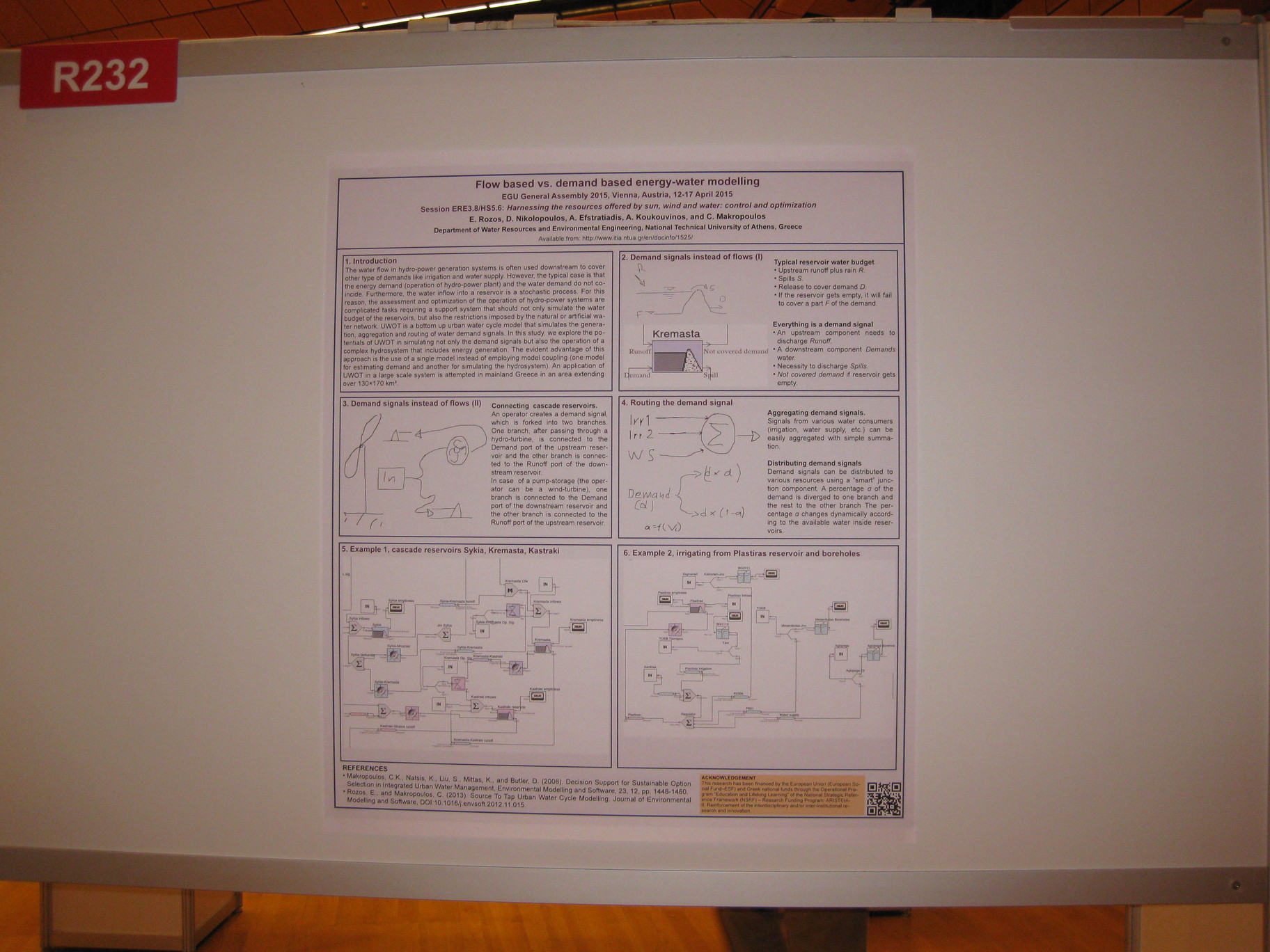
-
A. Koukouvinos, D. Nikolopoulos, A. Efstratiadis, A. Tegos, E. Rozos, S.M. Papalexiou, P. Dimitriadis, Y. Markonis, P. Kossieris, H. Tyralis, G. Karakatsanis, K. Tzouka, A. Christofides, G. Karavokiros, A. Siskos, N. Mamassis, and D. Koutsoyiannis, Integrated water and renewable energy management: the Acheloos-Peneios region case study, European Geosciences Union General Assembly 2015, Geophysical Research Abstracts, Vol. 17, Vienna, EGU2015-4912, doi:10.13140/RG.2.2.17726.69440, European Geosciences Union, 2015.
Within the ongoing research project “Combined Renewable Systems for Sustainable Energy Development” (CRESSENDO), we have developed a novel stochastic simulation framework for optimal planning and management of large-scale hybrid renewable energy systems, in which hydropower plays the dominant role. The methodology and associated computer tools are tested in two major adjacent river basins in Greece (Acheloos, Peneios) extending over 15 500 km2 (12% of Greek territory). River Acheloos is characterized by very high runoff and holds ~40% of the installed hydropower capacity of Greece. On the other hand, the Thessaly plain drained by Peneios – a key agricultural region for the national economy – usually suffers from water scarcity and systematic environmental degradation. The two basins are interconnected through diversion projects, existing and planned, thus formulating a unique large-scale hydrosystem whose future has been the subject of a great controversy. The study area is viewed as a hypothetically closed, energy-autonomous, system, in order to evaluate the perspectives for sustainable development of its water and energy resources. In this context we seek an efficient configuration of the necessary hydraulic and renewable energy projects through integrated modelling of the water and energy balance. We investigate several scenarios of energy demand for domestic, industrial and agricultural use, assuming that part of the demand is fulfilled via wind and solar energy, while the excess or deficit of energy is regulated through large hydroelectric works that are equipped with pumping storage facilities. The overall goal is to examine under which conditions a fully renewable energy system can be technically and economically viable for such large spatial scale.
Full text:
- http://www.itia.ntua.gr/en/getfile/1524/1/documents/EGU2015-4912.pdf: Abstract (36 KB)
- http://www.itia.ntua.gr/en/getfile/1524/2/documents/2015_egu_cressendo_final.pdf: Poster (2319 KB)
Additional material:
- http://www.itia.ntua.gr/en/getfile/1524/3/documents/R231.jpg: Photo (596 KB)
See also: http://dx.doi.org/10.13140/RG.2.2.17726.69440
Other works that reference this work (this list might be obsolete):
1. Stamou, A. T., and P. Rutschmann, Pareto optimization of water resources using the nexus approach, Water Resources Management, 32, 5053-5065, doi:10.1007/s11269-018-2127-x, 2018. 2. Stamou, A.-T., and P. Rutschmann, Optimization of water use based on the water-energy-food nexus concept: Application to the long-term development scenario of the Upper Blue Nile River, Water Utility Journal, 25, 1-13, 2020.
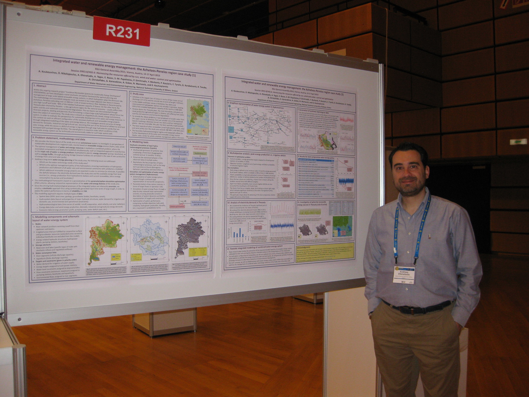
-
A. Zarkadoulas, K. Mantesi, A. Efstratiadis, A. D. Koussis, K. Mazi, D. Katsanos, A. Koukouvinos, and D. Koutsoyiannis, A hydrometeorological forecasting approach for basins with complex flow regime, European Geosciences Union General Assembly 2015, Geophysical Research Abstracts, Vol. 17, Vienna, EGU2015-3904, doi:10.13140/RG.2.2.21920.99842, European Geosciences Union, 2015.
The combined use of weather forecasting models and hydrological models in flood risk estimations is an established technique, with several successful applications worldwide. However, most known hydrometeorological forecasting systems have been established in large rivers with perpetual flow. Experience from small- and medium-scale basins, which are often affected by flash floods, is very limited. In this work we investigate the perspectives of hydrometeorological forecasting, by emphasizing two issues: (a) which modelling approach can credibly represent the complex dynamics of basins with highly variable runoff (intermittent or ephemeral); and (b) which transformation of point-precipitation forecasts provides the most reliable estimations of spatially aggregated data, to be used as inputs to semi-distributed hydrological models. Using as case studies the Sarantapotamos river basin, in Eastern Greece (145 km2), and the Nedontas river basin, in SW Peloponnese (120 km2), we demonstrate the advantages of continuous simulation through the HYDROGEIOS model. This employs conjunctive modelling of surface and groundwater flows and their interactions (percolation, infiltration, underground losses), which are key processes in river basins characterized by significantly variability of runoff. The model was calibrated against hourly flow data at two and three hydrometric stations, respectively, for a 3-year period (2011-2014). Next we attempted to reproduce the most intense flood events of that period, by substituting observed rainfall by forecast scenarios. In this respect, we used consecutive point forecasts of a 6-hour lead time, provided by the numerical weather prediction model WRF (Advanced Research version), dynamically downscaled from the ~1o forecast of GSF–NCEP/NOAA successively first to ~18 km, then to ~6 km and ultimately at the horizontal grid resolution of 2x2 km2. We examined alternative spatial integration approaches, using as reference the rainfall stations over the two basins. By combining consecutive rainfall forecasts at the sub-basin scale (a kind of ensemble prediction), we run the model in forecast mode to generate trajectories of flow predictions and associated uncertainty bounds.
Full text:
- http://www.itia.ntua.gr/en/getfile/1521/1/documents/EGU2015-3904.pdf: Abstract (42 KB)
- http://www.itia.ntua.gr/en/getfile/1521/2/documents/2015egu_flood_final.pdf: Poster (3343 KB)
-
T. Tsitseli, D. Koutsoyiannis, A. Koukouvinos, and N. Mamassis, Construction of ombrian curves using the Hydrognomon software system, Facets of Uncertainty: 5th EGU Leonardo Conference – Hydrofractals 2013 – STAHY 2013, Kos Island, Greece, doi:10.13140/RG.2.2.34517.01762, European Geosciences Union, International Association of Hydrological Sciences, International Union of Geodesy and Geophysics, 2013.
Hydrognomon is an application for the analysis of hydrological data and includes several applications for time series processing, such as time step aggregation and regularization, interpolation, regression analysis and infilling of missing values, consistency tests, data filtering, graphical and tabular visualization of time series, etc. Both its source code and the executable program are freely available. The new version of Hydrognomon includes a module for the construction of ombrian (intensity-duration-frequency) curves. It is based on a mathematical framework that expresses ombrian curves with unified relationships giving rain intensity in terms of duration and return period, either for a single gauging station or for a station group over a specified area. In the latter case, it supports either single parameters set or spatially varying parameters. The framework is completed with raw rainfall data processing, data management and storage, graphical user interface, and output data graphs and export facilities.
Full text: http://www.itia.ntua.gr/en/getfile/1393/1/documents/2013Kos_Ombrian.pdf (725 KB)
Additional material:
- http://www.itia.ntua.gr/en/getfile/1393/2/documents/Tsitseli.JPG: Photo of the first author in front of the poster (819 KB)
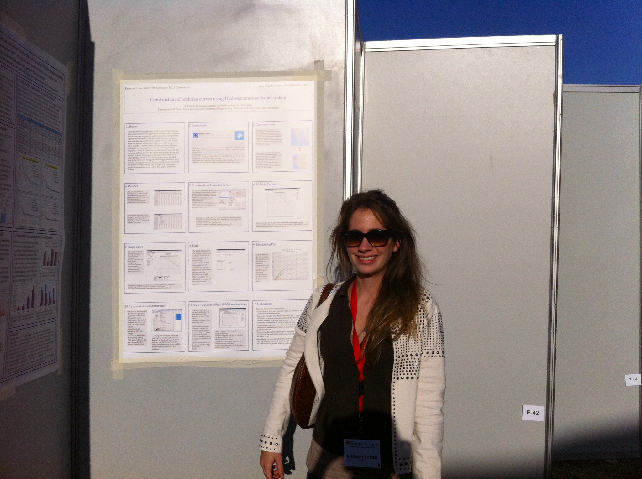
-
Y. Markonis, A. Efstratiadis, A. Koukouvinos, N. Mamassis, and D. Koutsoyiannis, Investigation of drought characteristics in different temporal and spatial scales: A case study in the Mediterranean region , Facets of Uncertainty: 5th EGU Leonardo Conference – Hydrofractals 2013 – STAHY 2013, Kos Island, Greece, European Geosciences Union, International Association of Hydrological Sciences, International Union of Geodesy and Geophysics, 2013.
In 1988-1995 Greece experienced a drought, one of the most extended (both in space and time) and intense since the beginning of hydro-meteorological instrumental measurements. The aim of this study is to describe the phenomenon in different temporal and spatial scales in order to (a) identify possible links with Mediterranean/global climatic regime and (b) to demonstrate the role of the marginal distribution and the autocorrelation function in estimating the return period of the drought and its impact. Three spatial scales were examined: the local scale (regions of Peloponnese in the southern and Macedonia in the northern part of Greece; ~2x2° each), the national scale (~8x8°) and the Mediterranean scale (~15x45°). In the time domain the monthly, annual and inter-annual time steps were taken, while the time horizon is that of the instrumental record as well as a broader time window obtained by introducing qualitative evidence from paleoclimatic studies. Our findings show both strong temporal variability and spatial heterogeneity, which imply enhanced uncertainty.
Full text: http://www.itia.ntua.gr/en/getfile/1390/1/documents/KosDroughtPoster.pdf (661 KB)
-
E. Michailidi, T. Mastrotheodoros, A. Efstratiadis, A. Koukouvinos, and D. Koutsoyiannis, Flood modelling in river basins with highly variable runoff, Facets of Uncertainty: 5th EGU Leonardo Conference – Hydrofractals 2013 – STAHY 2013, Kos Island, Greece, doi:10.13140/RG.2.2.30847.00167, European Geosciences Union, International Association of Hydrological Sciences, International Union of Geodesy and Geophysics, 2013.
In the Mediterranean area numerous small to medium-scale river basins are characterized by highly-variable runoff, intermittent or ephemeral. This is due to both the climatic regime and the geomorphological and physiographic peculiarities of the hydrological system itself. Typically, these basins are affected by flash floods, for which effective modelling can be more difficult than in the case of large basins with permanent runoff. In this study we compare different modelling approaches in two representative catchments (one in Greece and one in Cyprus), on the basis of a number of observed flood events. Initially, we employ the well-known SCS-CN method, combined with a synthetic unit hydrograph (SUH) approach, whose parameters (namely, the curve number, the initial abstraction ratio and the time-to-peak of the SUH) are calibrated against each individual flood event. Yet, even with calibrated parameters, the above method, which is widespread among flood engineers, generally fails to reproduce the observed hydrographs. Next, we test different modelling structures, all of which use elementary hydraulic analogues (by means of interconnected tanks) to represent the storage processes, which are dominant in such types of basins. For each event we run different settings of the calibration problem, thus obtaining a large set of alternative optimal parameter values. The significant variability of the parameter values reflects the complexity of the involved hydrological processes. In addition, it reveals the crucial role of flood measurements, in order to build realistic models and provide consistent estimations of the related uncertainties.
Full text: http://www.itia.ntua.gr/en/getfile/1385/1/documents/Kos_Basins_poster.pdf (1881 KB)
See also: http://dx.doi.org/10.13140/RG.2.2.30847.00167
Other works that reference this work (this list might be obsolete):
1. Taguas, E., Y. Yuan, F. Licciardello, and J. Gómez, Curve Numbers for olive orchard catchments: case study in Southern Spain, Journal of Irrigation and Drainage Engineering, doi:10.1061/(ASCE)IR.1943-4774.0000892, 05015003, 2015.
-
A. Efstratiadis, A. Koukouvinos, P. Dimitriadis, A. Tegos, N. Mamassis, and D. Koutsoyiannis, A stochastic simulation framework for flood engineering, Facets of Uncertainty: 5th EGU Leonardo Conference – Hydrofractals 2013 – STAHY 2013, Kos Island, Greece, doi:10.13140/RG.2.2.16848.51201, European Geosciences Union, International Association of Hydrological Sciences, International Union of Geodesy and Geophysics, 2013.
Flood engineering is typically tackled as a sequential application of formulas and models, with specific assumptions and parameter values, thus providing fully deterministic outputs. In this procedure, the unique probabilistic concept is the return period of rainfall, which is set a priori, to represent the acceptable risk of all design variables of interest (peak flows, flood hydrographs, flow depths and velocities, inundated areas, etc.). Yet, a more consistent approach would require estimating the risks by integrating the uncertainties of all individual variables. This option can be offered by stochastic simulation, which is the most effective and powerful technique for analysing systems of high complexity and uncertainty. This presupposes to recognize which of the modelling components represent time-varying processes and which ones represent unknown, thus uncertain, parameters. In the proposed framework both should be handled as random variables. The following computational steps are envisaged: (a) generation of synthetic time series of areal rainfall, through multivariate stochastic disaggregation models; (b) generation of random sets of initial soil moisture conditions; (c) run of hydrological and hydraulic simulation models with random sets of parameter values, picked from suitable distributions; (d) statistical analysis of the model outputs and determination of empirical pdfs; and (e) selection of the design value, which corresponds to the acceptable risk. This approach allows for estimating the full probability distribution of the output variables, instead of a unique value, as resulted by the deterministic procedure. In this context, stochastic simulation also offers the means to introduce the missing culture of uncertainty appreciation in flood engineering.
Full text: http://www.itia.ntua.gr/en/getfile/1384/1/documents/KosFloodStochSim.pdf (1860 KB)
-
V. Pagana, A. Tegos, P. Dimitriadis, A. Koukouvinos, P. Panagopoulos, and N. Mamassis, Alternative methods in floodplain hydraulic simulation - Experiences and perspectives, European Geosciences Union General Assembly 2013, Geophysical Research Abstracts, Vol. 15, Vienna, EGU2013-10283-2, European Geosciences Union, 2013.
Floods can simply be defined as the physical phenomena, during which an initially dry land area is covered by water. Floods are normally caused by extreme weather conditions, while their evolution depends mainly on geomorphologic factors, such as soil stability, vegetation cover, as well as the geometrical characteristics of the river basin. To prevent floods’ consequences, we have to study the hydraulic behavior of all the basins. Here, the study is focused on the upstream part of the Rafina basin, located in the east of Athens (Greece). Particularly, a hydraulic simulation is accomplished via the one-dimensional HEC-RAS and the quasi-two-dimensional LISFLOOD-FP and FLO-2D models. Additionally, a sensitivity analysis is carried out to investigate the effects of the floodplain and river roughness coefficients on the flood inundation in conjunction with a modern probabilistic view. Finally, a comparison between the three models is made regarding the simulated maximum water depth and maximum flow velocity.
Full text:
- http://www.itia.ntua.gr/en/getfile/1347/1/documents/Alternative_methods_in_floodplain_hydraulic_simulation_pr.pdf: Presentation (4185 KB)
- http://www.itia.ntua.gr/en/getfile/1347/2/documents/Alternative_methods_in_floodplain_hydraulic_simulation_po.pdf: Poster (5049 KB)
- http://www.itia.ntua.gr/en/getfile/1347/3/documents/Alternative_methods_in_floodplain_hydraulic_simulation_ab.pdf: Abstract (33 KB)
Other works that reference this work (this list might be obsolete):
1. #Μίχας, Σ. Ν., Κ. Ι. Νικολάου, Σ. Λ. Λαζαρίδου, και Μ. Ν. Πικούνης, Σύγκριση μαθηματικών ομοιωμάτων διόδευσης πλημμυρικού κύματος από υποθετική θραύσης φράγματος Αγιόκαμπου, Πρακτικά 2ου Πανελλήνιου Συνεδρίου Φραγμάτων και Ταμιευτήρων, Αθήνα, Αίγλη Ζαππείου, Ελληνική Επιτροπή Μεγάλων Φραγμάτων, 2013.
-
A. Oikonomou, P. Dimitriadis, A. Koukouvinos, A. Tegos, V. Pagana, P. Panagopoulos, N. Mamassis, and D. Koutsoyiannis, Floodplain mapping via 1D and quasi-2D numerical models in the valley of Thessaly, Greece, European Geosciences Union General Assembly 2013, Geophysical Research Abstracts, Vol. 15, Vienna, EGU2013-10366, doi:10.13140/RG.2.2.25165.03040, European Geosciences Union, 2013.
The European Union Floods Directive defines a flood as ‘a covering by water of land not normally covered by water’. Human activities, such as agriculture, urban development, industry and tourism, contribute to an increase in the likelihood and adverse impacts of flood events. The study of the hydraulic behaviour of a river is important in flood risk management. Here, we investigate the behaviour of three hydraulic models, with different theoretical frameworks, in a real case scenario. The area is located in the Penios river basin, in the plain of Thessaly (Greece). The three models used are the one-dimensional HEC-RAS and the quasi two-dimensional LISFLOOD-FP and FLO-2D which are compared to each other, in terms of simulated maximum water depth as well as maximum flow velocity, and to a real flood event. Moreover, a sensitivity analysis is performed to determine how each simulation is affected by the river and floodplain roughness coefficient, in terms of flood inundation.
Full text:
- http://www.itia.ntua.gr/en/getfile/1337/1/documents/FloodplainMapping_pr.pdf: Presentation (7388 KB)
- http://www.itia.ntua.gr/en/getfile/1337/2/documents/FloodplainMapping_pos.pdf: Poster (9353 KB)
- http://www.itia.ntua.gr/en/getfile/1337/3/documents/FloodplainMapping_abs.pdf: Abstract (34 KB)
See also: http://dx.doi.org/10.13140/RG.2.2.25165.03040
Other works that reference this work (this list might be obsolete):
1. #Μίχας, Σ. Ν., Κ. Ι. Νικολάου, Σ. Λ. Λαζαρίδου, και Μ. Ν. Πικούνης, Σύγκριση μαθηματικών ομοιωμάτων διόδευσης πλημμυρικού κύματος από υποθετική θραύσης φράγματος Αγιόκαμπου, Πρακτικά 2ου Πανελλήνιου Συνεδρίου Φραγμάτων και Ταμιευτήρων, Αθήνα, Αίγλη Ζαππείου, Ελληνική Επιτροπή Μεγάλων Φραγμάτων, 2013.
-
S. Kozanis, A. Christofides, A. Efstratiadis, A. Koukouvinos, G. Karavokiros, N. Mamassis, D. Koutsoyiannis, and D. Nikolopoulos, Using open source software for the supervision and management of the water resources system of Athens, European Geosciences Union General Assembly 2012, Geophysical Research Abstracts, Vol. 14, Vienna, 7158, doi:10.13140/RG.2.2.28468.04482, European Geosciences Union, 2012.
The water supply of Athens, Greece, is implemented through a complex water resource system, extending over an area of around 4 000 km2 and including surface water and groundwater resources. It incorporates four reservoirs, 350 km of main aqueducts, 15 pumping stations, more than 100 boreholes and 5 small hydropower plants. The system is run by the Athens Water Supply and Sewerage Company (EYDAP). Over more than 10 years we have developed, information technology tools such as GIS, database and decision support systems, to assist the management of the system. Among the software components, “Enhydris”, a web application for the visualization and management of geographical and hydrometeorological data, and “Hydrognomon”, a data analysis and processing tool, are now free software. Enhydris is entirely based on free software technologies such as Python, Django, PostgreSQL, and JQuery. We also created http://openmeteo.org/, a web site hosting our free software products as well as a free database system devoted to the dissemination of free data. In particular, “Enhydris” is used for the management of the hydrometeorological stations and the major hydraulic structures (aqueducts, reservoirs, boreholes, etc.), as well as for the retrieval of time series, online graphs etc. For the specific needs of EYDAP, additional GIS functionality was introduced for the display and monitoring of the water supply network. This functionality is also implemented as free software and can be reused in similar projects. Except for “Hydrognomon” and “Enhydris”, we have developed a number of advanced modeling applications, which are also generic-purpose tools that have been used for a long time to provide decision support for the water resource system of Athens. These are “Hydronomeas”, which optimizes the operation of complex water resource systems, based on a stochastic simulation framework, “Castalia”, which implements the generation of synthetic time series, and “Hydrogeios”, which employs conjunctive hydrological and hydrogeological simulation, with emphasis to human-modified river basins. These tools are currently available as executable files that are free for download though the ITIA web site (http://itia.ntua.gr/). Currently, we are working towards releasing their source code as well, through making them free software, after some licensing issues are resolved.
Full text:
- http://www.itia.ntua.gr/en/getfile/1201/1/documents/2012EGUAthensWS-2-slides.pdf: Presentation (slide format) (1412 KB)
- http://www.itia.ntua.gr/en/getfile/1201/4/documents/2012EGUAthensWS-2.pdf: Presentation (poster format) (1411 KB)
Additional material:
- http://www.itia.ntua.gr/en/getfile/1201/2/documents/EGU2012-7158-2.pdf: Abstract (38 KB)
- http://www.itia.ntua.gr/en/getfile/1201/3/documents/Enhydris-EYDAP_slides.pdf: Summary (presentation slides) (91 KB)
-
A. Christofides, S. Kozanis, G. Karavokiros, and A. Koukouvinos, Enhydris, Filotis & openmeteo.org: Free software for environmental management, FLOSS Conference 2011, Athens, http://conferences.ellak.gr/2011/, 2011.
A presentation of two free software application for environmental management, developed in National Technical University of Athens. Enhydris is an Information system - server software for the management, storage and retrieval of hydrometeorological data, accessible through the internet. Enhydris is used by the National Data Bank of Hydrometeorolical Information (Hydroscope) and it also used by other agencies in Greece and European Union. In addition it is provided as a service of free content under the web address: openmeteo.org where individuals can download or upload their data. The Information System for the Greek Nature "Filotis", contains biotopes and species of flora and fauna of Greece.
The development of the application is based on Python Computer Language and Django. Finally applications are providing geospatial data in a Web-GIS form by using free software GIS tools.
Speach video is here: http://www.vimeo.com/25340067
Related works:
- [112] Leaflet Filotis presentation
Full text: http://www.itia.ntua.gr/en/getfile/1145/1/documents/2011_FLOSS_Enhydris_presentation.pdf (3847 KB)
Additional material:
- http://www.itia.ntua.gr/en/getfile/1145/2/documents/2011_FLOSS_Enhydris_speach_doc.pdf: First part speach (70 KB)
See also: http://conferences.ellak.gr/2011/
-
K. Hadjibiros, N. Mamassis, A. Koukouvinos, and E. Kyritsis, Data base for the Greek nature (FILOTIS), The NTUA in the lead of research and technology , Athens, 2007.
Full text: http://www.itia.ntua.gr/en/getfile/877/1/documents/paper_filot.pdf (192 KB)
-
A. Efstratiadis, A. Koukouvinos, E. Rozos, I. Nalbantis, and D. Koutsoyiannis, Control of uncertainty in complex hydrological models via appropriate schematization, parameterization and calibration, European Geosciences Union General Assembly 2006, Geophysical Research Abstracts, Vol. 8, Vienna, 02181, doi:10.13140/RG.2.2.28297.65124, European Geosciences Union, 2006.
The recent expansion of complex, distributed modelling schemes results in significant increase of computational effort, thus making the traditional parameter estimation problem extremely difficult to handle. Recent advances provide a variety of mathematical techniques to quantify the uncertainty of model predictions. Despite their different theoretical background, such approaches aim to discover "promising" trajectories of the model outputs that correspond to multiple, "behavioural" parameter sets, rather than a single "global optimal" one. Yet, their application indicates that it is not unusual the case where model predictive uncertainty is comparable to the typical statistical uncertainty of the measured outputs, thus making the model validity at least questionable. Uncertainty is due to multiple sources that are interacted in a chaotic manner. Some of them are "inherent" and therefore unavoidable, as they are related to the complexity of physical processes, necessarily represented through simplified hypotheses about the watershed behaviour. Other sources are though controllable via appropriate schematization, parameterization and calibration. This involves adaptation of the principle of parsimony, appropriate distributed models and incorporation of hydrological experience within the parameter estimation procedure. The above issues are discussed on the basis of a conjunctive modelling scheme, fitted to two complex hydrosystems of Greece. A parsimonious structure is made possible by spatial analysis that is consistent with the available data and the operational requirements regarding water management, and the correspondence of model parameters to the "broad" physical characteristics of each system. Within the calibration strategy, the key concept is to exploit any type of knowledge, including systematic measurements as well as additional information about non-measured model outputs, in a multi-response optimization framework. The entire approach contributes to a significant reduction of uncertainties, as indicated by successful validation results.
Full text:
-
A. Efstratiadis, G. Karavokiros, S. Kozanis, A. Christofides, A. Koukouvinos, E. Rozos, N. Mamassis, I. Nalbantis, K. Noutsopoulos, E. Romas, L. Kaliakatsos, A. Andreadakis, and D. Koutsoyiannis, The ODYSSEUS project: Developing an advanced software system for the analysis and management of water resource systems, European Geosciences Union General Assembly 2006, Geophysical Research Abstracts, Vol. 8, Vienna, 03910, doi:10.13140/RG.2.2.24942.20805, European Geosciences Union, 2006.
The ODYSSEUS project (from the Greek acronym of its full title "Integrated Management of Hydrosystems in Conjunction with an Advanced Information System") aims at providing support to decision-makers towards integrated water resource management. The end-product comprises a system of co-operating software applications, suitable to handle a wide spectrum of water resources problems. The key methodological concepts are the holistic modelling approach, through the conjunctive representation of processes regarding water quantity and quality, man-made interventions, the parsimony of both input data requirements and system parameterization, the assessment of uncertainties and risks, and the extended use of optimization both for modelling (within various scales) and derivation of management policies. The core of the system is a relational database, named HYDRIA, for storing hydrosystem information; this includes geographical data, raw and processed time series, characteristics of measuring stations and facilities, and a variety of economic, environmental and water quality issues. The software architecture comprises various modules. HYDROGNOMON supports data retrieval, processing and visualization, and performs a variety of time series analysis tasks. HYDROGEIOS integrates a conjunctive hydrological model within a systems-oriented water management scheme, which estimates the available water resources at characteristic sites of the river basin and at the underlying aquifer. HYDRONOMEAS is the hydrosystem control module and locates optimal operation policies that minimize the risk and cost of decision-making. Additional modules are employed to prepare input data. DIPSOS estimates water needs for various uses (water supply, irrigation, industry, etc.), whereas RYPOS estimates pollutant loads from point and non-point sources, at a river basin scale. A last category comprises post-processing modules, for evaluating the proposed management policies by means of economical efficiency and water quality requirements. The latter include sophisticated models that estimate the space and time variation of specific pollutants within rivers (HERIDANOS) and lakes (LERNE), as well as simplified versions of them to be used within the hydrosystem simulation scheme. An interactive framework enables the exchange of data between the various modules, either off-line (through the database) or on-line, via appropriate design of common information structures. The whole system is in the final phase of its development and parts of it have been already tested in operational applications, by water authorities, organizations and consulting companies.
Full text:
- http://www.itia.ntua.gr/en/getfile/706/1/documents/2006EGUSoftwareAbs.pdf: Abstract (31 KB)
- http://www.itia.ntua.gr/en/getfile/706/2/documents/2006EGUSoftwarePoster.pdf: Poster (910 KB)
Additional material:
- http://www.itia.ntua.gr/en/getfile/706/3/documents/2006EGUOdysseasLeaflet.pdf: Broschure (306 KB)
-
A. Efstratiadis, A. Tegos, I. Nalbantis, E. Rozos, A. Koukouvinos, N. Mamassis, S.M. Papalexiou, and D. Koutsoyiannis, Hydrogeios, an integrated model for simulating complex hydrographic networks - A case study to West Thessaly region, 7th Plinius Conference on Mediterranean Storms, Rethymnon, Crete, doi:10.13140/RG.2.2.25781.06881, European Geosciences Union, 2005.
An integrated scheme, comprising a conjunctive hydrological model and a systems oriented management model, was developed, based on a semi-distributed approach. Geographical input data include the river network, the sub-basins upstream of each river node and the aquifer dicretization in the form of groundwater cells of arbitrary geometry. Additional layers of distributed geographical information, such as geology, land cover and terrain slope, are used to define the hydrological response units. Various modules are combined to represent the main processes at the water basin such as, soil moisture, groundwater, flood routing and water management models. Model outputs include river discharges, spring flows, groundwater levels and water abstractions. The model can be implemented in daily and monthly basis. A case study to the West Thessaly region performed. The discharges of five hydrometric stations and the water levels of eight boreholes were used simultaneously for model calibration. The implementation of the model to the certain region demonstrated satisfactory agreement between the observed and the simulated data.
Full text:
- http://www.itia.ntua.gr/en/getfile/693/1/documents/2005PliniusHydrogeiosAbs.pdf: Abstract (4 KB)
- http://www.itia.ntua.gr/en/getfile/693/2/documents/2005PliniusHydrogeiosPres.pdf: Poster presentation (806 KB)
-
A. Efstratiadis, E. Rozos, A. Koukouvinos, I. Nalbantis, G. Karavokiros, and D. Koutsoyiannis, An integrated model for conjunctive simulation of hydrological processes and water resources management in river basins, European Geosciences Union General Assembly 2005, Geophysical Research Abstracts, Vol. 7, Vienna, 03560, doi:10.13140/RG.2.2.27930.64960, European Geosciences Union, 2005.
In complex hydrosystems, where natural processes are significantly affected by human interventions, a holistic modelling concept is required, to ensure a more faithful representation of mechanisms and hence a rational water resource management. An integrated scheme, comprising a conjunctive (i.e., surface and groundwater) hydrological model and a systems-oriented management model, was developed, based on a semi-distributed approach. Geographical input data include the river network, the sub-basins upstream of each river node and the aquifer discretization in the form of groundwater cells of arbitrary geometry. Additional layers of distributed geographical information, such as geology, land cover and terrain slope, are used to define the hydrological response units (HRUs); the latter are spatial components that correspond to areas of homogenous hydrological characteristics. On the other hand, input data for artificial components include reservoirs, water abstraction facilities, aqueducts and demand points. Dynamic input data consist of precipitation and potential evapotranspiration series, given at a sub-basin scale, and target demand series. Targets refer not only to water needs but also to various water management constraints, such as the preservation of minimum flows across the river network. Various modules are combined to represent the key processes in the watershed, i.e. (a) a conceptual soil moisture accounting model, with different parameters assigned to each HRU; (b) a groundwater model, based on a modified finite-volume numerical method; (c) a routing model, that implements the water movement across the river network; and (d) a water management model, inspired from the graph theory, which estimates the optimal hydrosystem fluxes, satisfying both physical constraints and target priorities and simultaneously minimising costs. Model outputs include discharges through the river network, spring flows, groundwater levels and water abstractions. The calibration employs an automatic procedure, based on multiple error criteria and a robust global optimisation algorithm. The model was applied to a meso-scale (~2000 km2) watershed in Greece, characterised by a complex physical system (a karstified background, with extended losses to the sea) and conflicting water uses. 10-year monthly discharge series from seven gauging stations were used to evaluate the model performance. Extended analysis proved that the exploitation of spatially distributed input information, in addition to the usage of a reasonable number of control variables that are fitted to multiple observed responses, ensures more realistic model parameters, also reducing prediction uncertainty, in comparison to earlier (both fully conceptual and fully distributed) approaches. Moreover, the incorporation of the water resource management scheme within the hydrological simulator makes the model suitable for operational use.
Full text:
- http://www.itia.ntua.gr/en/getfile/644/1/documents/2005EGUHydroModelAbs.pdf: Abstract (34 KB)
- http://www.itia.ntua.gr/en/getfile/644/2/documents/2005EGUHydrogeiosA2.pdf: Poster, size A2 (767 KB)
- http://www.itia.ntua.gr/en/getfile/644/3/documents/2005EGUHydrogeiosA0.pdf: Poster, size A0 (613 KB)
- http://www.itia.ntua.gr/en/getfile/644/4/documents/2005EGUHydrogeiosA4.pdf: Print friendly version, A4 (451 KB)
Presentations and publications in workshops
-
D. Koutsoyiannis, T. Iliopoulou, A. Koukouvinos, N. Malamos, N. Mamassis, P. Dimitriadis, N. Tepetidis, and D. Markantonis, Extreme rainfall modelling for engineering design: a new methodology and its application over the Greek territory (invited), Risk Management: Extremes of Flood and Drought, Europe/China, UNESCO, 2023.
Remarks:
Video of presentation: https://www.iahr.org/video/clip?id=1500
Video of discussion: https://www.iahr.org/video/clip?id=1502
Videos of the entire event: https://www.iahr.org/video/clip?id=1496
Full text: http://www.itia.ntua.gr/en/getfile/2270/1/documents/UNESCO_China2.pdf (3617 KB)
-
A. Tsouni, S. Sigourou, V. Pagana, D. Koutsoyiannis, N. Mamassis, A. Koukouvinos, P. Dimitriadis, T. Iliopoulou, G.-F. Sargentis, R. Ioannidis, D. Dimitrakopoulou, E. Chardavellas, S. Vavoulogiannis, and V. Kyriakouli, Flood risk assessment in the Pikrodafni basin, Presentation of results for the 1st Phase of the Program Agreement between Attica Regional Authority and NOA, Athens, National Observatory of Athens, 2022.
Full text: http://www.itia.ntua.gr/en/getfile/2190/1/documents/20220516.pdf (13374 KB)
-
A. Efstratiadis, N. Mamassis, A. Koukouvinos, T. Iliopoulou, S. Antoniadi, and D. Koutsoyiannis, Strategic plan for developing a National Hydrometric Network, Hellenic Integrated Marine and Inland water Observing, Forecasting and offshore Technology System (HIMIOFoTS) - Second meeting of project partners, Department of Water Resources and Environmental Engineering – National Technical University of Athens, 2019.
Full text: http://www.itia.ntua.gr/en/getfile/1973/1/documents/NTUA_pres_June2019_PartB.pdf (2262 KB)
-
N. Mamassis, A. Efstratiadis, A. Koukouvinos, and D. Koutsoyiannis, Open Hydrosystem Information Network (OpenHi.net): Evolution of works, challeneges and perspectives, Hellenic Integrated Marine and Inland water Observing, Forecasting and offshore Technology System (HIMIOFoTS) - Second meeting of project partners, Department of Water Resources and Environmental Engineering – National Technical University of Athens, 2019.
-
N. Mamassis, A. Efstratiadis, D. Koutsoyiannis, and A. Koukouvinos, Open Hydrosystem Information Network (OpenHi.net), Hellenic Integrated Marine and Inland water Observing, Forecasting and offshore Technology System (HIMIOFoTS) - First meeting of project partners, Anavyssos, Hellenic Centre for Marine Research, 2018.
Full text: http://www.itia.ntua.gr/en/getfile/1872/1/documents/NTUA_pres_HCMR_Sep2018_dnpy8Eq.pdf (4637 KB)
-
Ο. Daskalou, A. Koukouvinos, A. Efstratiadis, and D. Koutsoyiannis, Methodology for optimal allocation and sizing of renewable energy sources using ArcGIS 10.3: Case study of Thessaly Perfecture, 24th Hellenic Meeting of ArcGIS Users, Crowne Plaza, Athens, Marathon Data Systems, 2016.
Full text: http://www.itia.ntua.gr/en/getfile/1616/2/documents/MDS-Olympia.pdf (2133 KB)
Additional material:
- http://www.itia.ntua.gr/en/getfile/1616/1/documents/MDS_SYNEDRIO_2016_1.pdf: Broschure (2979 KB)
-
A. Efstratiadis, A. Koukouvinos, N. Mamassis, and D. Koutsoyiannis, The quantitative dimension of WFD 2000/60, Water Framework Directive 2000/60 and Inland Water Protection: Research and Perspectives, Athens, Hellenic Centre for Marine Research, Specific Secreteriat of Water – Ministry of Environment, Energy and Climate Change, 2015.
Full text: http://www.itia.ntua.gr/en/getfile/1541/1/documents/2015_WFDQuantity1.pdf (787 KB)
-
A. Koukouvinos, Proposed methodological framework of flood hydrology, Workshop - Deucalion research project, Goulandris National Histroy Museum, 2014.
Full text: http://www.itia.ntua.gr/en/getfile/1468/1/documents/Presentation_Flood_Specifications.pdf (616 KB)
-
A. Tegos, A. Efstratiadis, A. Varveris, N. Mamassis, A. Koukouvinos, and D. Koutsoyiannis, Assesment and implementation of ecological flow constraints in large hydroelectric works: The case of Acheloos, Ecological flow of rivers and the importance of their true assesment, 2014.
Full text: http://www.itia.ntua.gr/en/getfile/1455/1/documents/2014_envflows_pres.pdf (1344 KB)
-
A. D. Koussis, S. Lykoudis, A. Efstratiadis, A. Koukouvinos, N. Mamassis, D. Koutsoyiannis, A. Peppas, and A. Maheras, Estimating flood flows in ungauged Greek basins under hydroclimatic variability (Deukalion project) - Development of physically-established conceptual-probabilistic framework and computational tools, Climate and Environmental Change in the Mediterranean Region, Pylos, Navarino Environmental Observatory, 2012.
Full text: http://www.itia.ntua.gr/en/getfile/1292/1/documents/DeflkalionPoster.pdf (258 KB)
-
D. Koutsoyiannis, A. Andreadakis, R. Mavrodimou, A. Koukouvinos, and N. Mamassis, The Master Plan for the water resource management of Greece (invited talk), International Conference: Integrated Management of Coastal Areas, Faliro, doi:10.13140/RG.2.2.30398.08005, CoPraNet, Mediterranean SOS, 2006.
Full text:
- http://www.itia.ntua.gr/en/getfile/741/1/documents/2006ConfCoastWRM.pdf: Presentation (967 KB)
- http://www.itia.ntua.gr/en/getfile/741/2/documents/2006ConfCoastWRMSM.pdf: Presentation, condensed version (887 KB)
-
D. Koutsoyiannis, A. Efstratiadis, and A. Koukouvinos, Hydrological investigation of the Plastiras lake management, Workshop for the presentation of the research project "Investigation of scenarios for the management and protection of the quality of the Plastiras Lake", doi:10.13140/RG.2.2.16950.09286, Municipality of Karditsa, Karditsa, 2002.
To protect the Plastiras Lake, a high quality of the natural landscape and a satisfactory water quality must be ensured, the conflicting water uses and demands must be arranged and effective water management practices must be established. This study focuses on the hydrological point-of-view of reservoir's operation, which is one of the three components of its management. The analysis is based on the collection and processing of the necessary geographical, hydrological and meteorological data. The main subject of the study is to investigate the safe yield capabilities for several minimum allowable reservoir level scenarios, by applying modern stochastic simulation and optimisation methods. The final product is to propose suitable management policies, through which the maximisation of water supply and irrigation withdrawals for a high reliability level can be ensured, after imposing the minimum reservoir level restriction.
Full text:
- http://www.itia.ntua.gr/en/getfile/510/1/documents/2002Plastiras.pdf: Presentation (477 KB)
- http://www.itia.ntua.gr/en/getfile/510/2/documents/2002PlastirasSM.pdf: Presentation, condensed version (BW) (445 KB)
-
E. Rozos, D. Koutsoyiannis, and A. Koukouvinos, Supervision and investigation of the boreholes of the Yliki area using geographical information system, 7th meeting of the Greek users of ArcInfo, Marathon Data Systems, 1997.
Full text: http://www.itia.ntua.gr/en/getfile/92/1/documents/1997GISRozos.pdf (233 KB)
-
D. Hadjichristos, D. Koutsoyiannis, and A. Koukouvinos, Investigation of the design of storm sewer networks using geographical information system, 5th meeting of the Greek users of ArcInfo, Marathon Data Systems, 1995.
Full text: http://www.itia.ntua.gr/en/getfile/96/1/documents/1995GISHadjichristos.pdf (280 KB)
Educational notes
-
N. Mamassis, A. Koukouvinos, and A. Efstratiadis, Lecture notes: Geographical Information Systems for Hydrology, School of Pedagogical & Technological Education (ASPAITE), 2017.
Full text: http://www.itia.ntua.gr/en/getfile/1935/1/documents/Aspaite_GIS.pdf (6633 KB)
Research reports
-
D. Koutsoyiannis, T. Iliopoulou, A. Koukouvinos, N. Malamos, N. Mamassis, P. Dimitriadis, N. Tepetidis, and D. Markantonis, Technical Report, Production of maps with updated parameters of the ombrian curves at country level (implementation of the EU Directive 2007/60/EC in Greece), Department of Water Resources and Environmental Engineering – National Technical University of Athens, 2023.
Related project: Production of maps with updated parameters of the ombrian curves at country level (implementation of the EU Directive 2007/60/EC in Greece)
Full text: http://www.itia.ntua.gr/en/getfile/2273/1/documents/ntua_ombrian_reportF4.pdf (12849 KB)
Additional material:
- http://www.itia.ntua.gr/en/getfile/2273/2/documents/ombrian_parameters.zip: Grid of ombrian parameters across Greece (669 KB)
- http://www.itia.ntua.gr/en/getfile/2273/3/documents/MapMeanDailyRainfallGreece.zip: Grid of mean daily precipitation across Greece (599 KB)
-
N. Mamassis, D. Koutsoyiannis, A. Efstratiadis, A. Koukouvinos, and I. Papageorgaki, Dissemination actions (papers, conferences), Open Hydrosystem Information Network (OpenHi.net), Contractor: Department of Water Resources and Environmental Engineering – National Technical University of Athens, 84 pages, October 2021.
This report includes the description of dissemination and publicity actions of the sub-project regarding the development and preliminary operation of the OpenHi.net information system. The actions include the public information seminar of the sub-project, three publications in international conferences and a publication in an international peer reviewed scientific journal.
Related project: Open Hydrosystem Information Network (OpenHi.net)
Full text: http://www.itia.ntua.gr/en/getfile/2157/1/documents/OpenHi_Report1.2.pdf (15937 KB)
-
N. Mamassis, and A. Koukouvinos, Diaries of internal meetings, Open Hydrosystem Information Network (OpenHi.net), Contractor: Department of Water Resources and Environmental Engineering – National Technical University of Athens, 30 pages, October 2021.
In this report detailed description of the meetings of the sub-project OpenHi.net team and the meetings with groups of related sub-projects in the framework of HIMIOFoTS, are described. All meetings are concerning the internal coordination of the project implementation team and the coordination of sub-projects directly related to the development and preliminary operation of the OpenHi.net web-based software system.
Related project: Open Hydrosystem Information Network (OpenHi.net)
Full text: http://www.itia.ntua.gr/en/getfile/2156/1/documents/OpenHi_Report1_1.pdf (629 KB)
-
I. Papageorgaki, and A. Koukouvinos, Technical report. Organization of geographical data, Open Hydrosystem Information Network (OpenHi.net), Contractor: Department of Water Resources and Environmental Engineering – National Technical University of Athens, October 2021.
Open Hydrosystem Information Network (OpenHi.net) is a large-scale surface-water monitoring infrastructure for Greece, providing free access to water data and incorporating existing networks that manage their own databases. OpenΗiGis is the GIS component of the system, helping in linking stream flow to hydrological characteristics of upstream basins. The main goal is to collect, query and analyse data, to offer web-services related to hydrological-geographical information for watercourses and hydrographic networks, lakes and reservoirs, stream drainage basins and basins upstream of monitoring stations at the national level. Stored watercourses attributes are segment length and slope, geographical name and stream order. Attributes stored for lakes and reservoirs are area, elevation and geographical name. Attributes stored for basins (river basins, drainage basins, monitoring stations upstream basins) are area, mean elevation, mean slope, basin order, main watercourse length and slope, mean curve number. Spatial relationships between features (watercourses, basins, nodes) are defined using relevant and validated topological rules. A toolbox with several models was created to perform the geographical processes and to run calculations of spatial and geomorphological attributes. Such models, for example, are: watercourse extraction, hydrographic network definition, river basin delineation, geodatabase creation, data import from various sources and data export to the geodabase, a naming model to give name to each segment, basin’s mean curve number calculation. Web Map Services (WMS) and Web Feature Services (WFS) are provided to access, query and download the data through the OpenHi.net platform.
Related project: Open Hydrosystem Information Network (OpenHi.net)
Full text: http://www.itia.ntua.gr/en/getfile/2155/1/documents/OpenHi_Report4.pdf (3374 KB)
-
N. Mamassis, A. Efstratiadis, A. Koukouvinos, and D. Koutsoyiannis, Technical report: Evaluation of the preliminary operation of OpenHi.net system, Open Hydrosystem Information Network (OpenHi.net), Contractor: Department of Water Resources and Environmental Engineering – National Technical University of Athens, 47 pages, October 2021.
The preliminary operation of the online information system OpenHi.net is evaluated based on the qualitative specifications and the corresponding operational requirements. In detail, the evaluation includes the functionality of the provided services and applications (for time series, statistical information, graphs, maps), the cooperation with measurement networks and third party databases, and the system's potential for expansion are evaluated.
Related project: Open Hydrosystem Information Network (OpenHi.net)
Full text: http://www.itia.ntua.gr/en/getfile/2154/1/documents/OpenHi_Report3.2Fin.pdf (2556 KB)
-
N. Mamassis, A. Efstratiadis, A. Koukouvinos, and D. Koutsoyiannis, Technical report: Development of a national monitoring system for surface water resources, Open Hydrosystem Information Network (OpenHi.net), Contractor: Department of Water Resources and Environmental Engineering – National Technical University of Athens, Τεύχος 2.1, June 2019.
Related project: Open Hydrosystem Information Network (OpenHi.net)
Full text:
- http://www.itia.ntua.gr/en/getfile/1977/1/documents/OpenHi_Report2_v1.pdf: Main report (8789 KB)
- http://www.itia.ntua.gr/en/getfile/1977/2/documents/OpenHi_Report2_annexEL01.pdf: Annex 1: Evaluation of hydrometric stations of WD01 (5085 KB)
- http://www.itia.ntua.gr/en/getfile/1977/3/documents/OpenHi_Report2_annexEL02.pdf: Annex 2: Evaluation of hydrometric stations of WD02 (4333 KB)
- http://www.itia.ntua.gr/en/getfile/1977/4/documents/OpenHi_Report2_annexEL03_AaZPROH.pdf: Annex 3: Evaluation of hydrometric stations of WD03 (1966 KB)
- http://www.itia.ntua.gr/en/getfile/1977/5/documents/OpenHi_Report2_annexEL04.pdf: Annex 4: Evaluation of hydrometric stations of WD04 (4489 KB)
- http://www.itia.ntua.gr/en/getfile/1977/6/documents/OpenHi_Report2_annexEL05_6HAGPsH.pdf: Annex 5: Evaluation of hydrometric stations of WD05 (5141 KB)
- http://www.itia.ntua.gr/en/getfile/1977/7/documents/OpenHi_Report2_annexEL06_KPv6TCu.pdf: Annex 6: Evaluation of hydrometric stations of WD06 (2916 KB)
- http://www.itia.ntua.gr/en/getfile/1977/8/documents/OpenHi_Report2_annexEL07.pdf: Annex 7: Evaluation of hydrometric stations of WD07 (2436 KB)
- http://www.itia.ntua.gr/en/getfile/1977/9/documents/OpenHi_Report2_annexEL08.pdf: Annex 8: Evaluation of hydrometric stations of WD08 (5453 KB)
- http://www.itia.ntua.gr/en/getfile/1977/10/documents/OpenHi_Report2_annexEL09.pdf: Annex 9: Evaluation of hydrometric stations of WD09 (7317 KB)
- http://www.itia.ntua.gr/en/getfile/1977/11/documents/OpenHi_Report2_annexEL10.pdf: Annex 10: Evaluation of hydrometric stations of WD10 (3761 KB)
- http://www.itia.ntua.gr/en/getfile/1977/12/documents/OpenHi_Report2_annexEL11.pdf: Annex 11: Evaluation of hydrometric stations of WD11 (4097 KB)
- http://www.itia.ntua.gr/en/getfile/1977/13/documents/OpenHi_Report2_annexEL12.pdf: Annex 12: Evaluation of hydrometric stations of WD12 (3770 KB)
- http://www.itia.ntua.gr/en/getfile/1977/14/documents/OpenHi_Report2_annexEL13.pdf: Annex 13: Evaluation of hydrometric stations of WD13 (4333 KB)
- http://www.itia.ntua.gr/en/getfile/1977/15/documents/OpenHi_Report2_annexEL14.pdf: Annex 14: Evaluation of hydrometric stations of WD14 (1842 KB)
-
C. Makropoulos, A. Efstratiadis, G. Karakatsanis, D. Nikolopoulos, and A. Koukouvinos, Final raw water financial costing report, Update of financial cost of raw water for the water supply of Athens , 120 pages, Department of Water Resources and Environmental Engineering – National Technical University of Athens, May 2018.
Related project: Update of financial cost of raw water for the water supply of Athens
-
N. Mamassis, D. Koutsoyiannis, A. Efstratiadis, and A. Koukouvinos, Technical report: Specification analysis of OpenHi.net system, Open Hydrosystem Information Network (OpenHi.net), Contractor: Department of Water Resources and Environmental Engineering – National Technical University of Athens, 29 pages, Τεύχος 3.1, September 2018.
Specifications for the web-based software system OpenHi.net are defined and associated requirements refering to its operational characteristics, geographical components management, measurement stations and related (raw and processed) data, and provided services and applications, are concluded.
Related project: Open Hydrosystem Information Network (OpenHi.net)
Full text: http://www.itia.ntua.gr/en/getfile/1879/1/documents/OpenHi_Report3.pdf (1168 KB)
-
C. Makropoulos, A. Efstratiadis, G. Karakatsanis, D. Nikolopoulos, and A. Koukouvinos, Calculation of financial cost of raw water - Synoptic report, Update of financial cost of raw water for the water supply of Athens , 93 pages, Department of Water Resources and Environmental Engineering – National Technical University of Athens, February 2018.
Related project: Update of financial cost of raw water for the water supply of Athens
-
A. Koukouvinos, A. Efstratiadis, D. Nikolopoulos, H. Tyralis, A. Tegos, N. Mamassis, and D. Koutsoyiannis, Case study in the Acheloos-Thessaly system, Combined REnewable Systems for Sustainable ENergy DevelOpment (CRESSENDO), 98 pages, Department of Water Resources and Environmental Engineering – National Technical University of Athens, October 2015.
This report describes the validation of methodologies and computer tools that have been developed in the context of the research project, in the interconnected river basin system of Acheloos and Peneios. The study area is modelled as a hypothetically closed and autonomous (in terms of energy balance) system, in order to investigate the perspectives of sustainable development at the peripheral scale, merely based on renewable energy.
Related project: Combined REnewable Systems for Sustainable ENergy DevelOpment (CRESSENDO)
Full text: http://www.itia.ntua.gr/en/getfile/1613/1/documents/Report_EE4a.pdf (8010 KB)
-
Y. Markonis, S. Lykoudis, A. Efstratiadis, and A. Koukouvinos, Description of rainfall and meteorological data and processing, DEUCALION – Assessment of flood flows in Greece under conditions of hydroclimatic variability: Development of physically-established conceptual-probabilistic framework and computational tools, Contractors: ETME: Peppas & Collaborators, Grafeio Mahera, Department of Water Resources and Environmental Engineering – National Technical University of Athens, National Observatory of Athens, 54 pages, September 2014.
Objective of this report is the analysis of rainfall and meteorological data that are gathered from the pilot basins and the description of their processing for the generation of the essential time series. The time series that are derived through processing of real-time raw data from the monitoring network are: (a) point time series of rainfall and other meteorological variables (temperature, relative humidity, wind velocity), and (b) time series of areal rainfall and potential evapotranspiration across all sub-basins of interest. Point rainfall depths from rain gauges are used for the generation of areal time series as well as the analysis of intense storm events. The extraction of areal rainfall across each basin or sub-basin of interest was done through typical techniques of spatial integration (Thiessen polygons), while the potential evapotranspiration data were indirectly estimated, as function of temperature.
Full text: http://www.itia.ntua.gr/en/getfile/1496/1/documents/Report_2_2.pdf (3082 KB)
-
A. Efstratiadis, A. Koukouvinos, E. Michailidi, E. Galiouna, K. Tzouka, A. D. Koussis, N. Mamassis, and D. Koutsoyiannis, Description of regional approaches for the estimation of characteristic hydrological quantities, DEUCALION – Assessment of flood flows in Greece under conditions of hydroclimatic variability: Development of physically-established conceptual-probabilistic framework and computational tools, Contractors: ETME: Peppas & Collaborators, Grafeio Mahera, Department of Water Resources and Environmental Engineering – National Technical University of Athens, National Observatory of Athens, 146 pages, September 2014.
The objective of the report is the systematic investigation and evaluation of regional relationships and associated event-based models that are applied in flood studies, through validating their predictions across the pilot basins of the project. The research focuses on the most popular, in Greece as well as globally, hydrological design procedure, which is based on the application of the SCS-CN method for the estimation of hydrological losses, combined with the unit hydrograph theory for the transformation of surface runoff to flood hydrograph at the basin outlet. In the report are investigated both the theoretical-conceptual background of the models as well as the procedure for estimating their basic input quantities (time of concentration, runoff curve number, initial abstraction ratio, initial soil moisture conditions). In this respect, we analyzed more than 100 flood events in 11 sites of interest, which we attempted to represent through several alternative approaches. The analyses showed that it is essential to revise critical aspects of the hydrological design. The most important are: (a) the correction of the time of concentration, as estimated by the Giandotti formula, according to the rainfall intensity; (b) the estimation of parameter CN of the SCS-CN method on the basis of three characteristic layers of spatial information and its adjustment for given initial abstraction ratio; (c) the application of a parametric synthetic unit hydrograph, the time parameters of which depend not only on the characteristics of the basin’s surface but also the mechanisms of the shallow soil; and (d) the statistically consistent estimation of the flood design quantities on the basis of the probabilities of occurrence of the design rainfall under dry, medium or wet antecedent soil moisture conditions.
Full text: http://www.itia.ntua.gr/en/getfile/1495/1/documents/Report_3_3.pdf (28157 KB)
-
A. Efstratiadis, A. Koukouvinos, P. Dimitriadis, E. Rozos, and A. D. Koussis, Theoretical documentation of hydrological-hydraulic simulation model, DEUCALION – Assessment of flood flows in Greece under conditions of hydroclimatic variability: Development of physically-established conceptual-probabilistic framework and computational tools, Contractors: ETME: Peppas & Collaborators, Grafeio Mahera, Department of Water Resources and Environmental Engineering – National Technical University of Athens, National Observatory of Athens, 108 pages, September 2014.
We present the theoretical documentation of the hydrological-hydraulic simulation model that has been developed within the new version of computer system Hydrogeios. The model has been enhanced in order to represent the hydrological processes at the hourly time scale, which allows to be used for both hydrological design and flood forecasting. In the report are described in detail the whole theoretical background, based on the integration of simulation models for surface- and groundwater processes, water resources management models, and alternative numerical schemes for flow routing along the river network. Moreover, we explain the procedure for preparation of input data and construction of all essential thematic layers, as well as the procedure for estimating model parameters through advanced calibration tools.
Full text: http://www.itia.ntua.gr/en/getfile/1491/1/documents/Report_3_5.pdf (3568 KB)
Other works that reference this work (this list might be obsolete):
1. Στεφανίδης, Σ. Ντάφης, και Χ. Γιάνναρος, Υδρολογική απόκριση της λεκάνης απορροής του χειμάρρου «Μπασδέκη» Ολυμπιάδας στην καταιγίδα της 25ης Νοεμβρίου 2019, Υδροτεχνικά (2019-2020), 29, 13-26, 2020.
-
A. Koukouvinos, Geographical data and procesing, DEUCALION – Assessment of flood flows in Greece under conditions of hydroclimatic variability: Development of physically-established conceptual-probabilistic framework and computational tools, Contractors: ETME: Peppas & Collaborators, Grafeio Mahera, Department of Water Resources and Environmental Engineering – National Technical University of Athens, National Observatory of Athens, 36 pages, March 2012.
Full text: http://www.itia.ntua.gr/en/getfile/1216/1/documents/Report_WP2_1.pdf (3456 KB)
-
N. Mamassis, A. Efstratiadis, G. Karavokiros, S. Kozanis, and A. Koukouvinos, Final report, Maintenance, upgrading and extension of the Decision Support System for the management of the Athens water resource system, Contractors: , Report 2, 84 pages, Department of Water Resources and Environmental Engineering – National Technical University of Athens, November 2011.
Related project: Maintenance, upgrading and extension of the Decision Support System for the management of the Athens water resource system
-
C. Makropoulos, D. Damigos, A. Efstratiadis, A. Koukouvinos, and A. Benardos, Synoptic report and final conclusions, Cost of raw water of the water supply of Athens, 32 pages, Department of Water Resources and Environmental Engineering – National Technical University of Athens, October 2010.
Related project: Cost of raw water of the water supply of Athens
Full text: http://www.itia.ntua.gr/en/getfile/1099/1/documents/Kostos_Nerou_EYDAP_Teuxos_5.pdf (418 KB)
Other works that reference this work (this list might be obsolete):
1. #Makropoulos, C., and E. Papatriantafyllou, Developing roadmaps for the sustainable management of the urban water cycle: The case of WW reuse in Athens, Proceedings of the 13th International Conference of Environmental Science and Technology, Athens, 2013.
-
C. Makropoulos, A. Efstratiadis, and A. Koukouvinos, Appraisal of financial cost and proposals for a rational management of the hydrosystem, Cost of raw water of the water supply of Athens, 73 pages, Department of Water Resources and Environmental Engineering – National Technical University of Athens, October 2010.
Related project: Cost of raw water of the water supply of Athens
Full text: http://www.itia.ntua.gr/en/getfile/1097/1/documents/Kostos_Nerou_EYDAP_Teuxos_3.pdf (1053 KB)
Other works that reference this work (this list might be obsolete):
1. Baki, S., and C. Makropoulos, Tools for energy footprint assessment in urban water systems, Procedia Engineering, 89, 548-556, doi:10.1016/j.proeng.2014.11.477, 2014. 2. #Di Federico, V., C. Makropoulos, A. Monteiro, T. Liserra, S. Baki, and A. Galvão, The TRUST approach for the Transition to Sustainability of Urban Water Services: the water scarcity cluster, Water IDEAS 2014 - Intelligent Distribution for Efficient and Affordable Supplies, International Water Association (IWA), Bologna, Italy, 2014. 3. Frijns, J., E. Cabrera Marchet, N. Carriço, D. Covas, A. J. Monteiro, H. M. Ramos, A. Bolognesi, C. Bragalli, S. Baki, and C. Makropoulos, Management tools for hydro energy interventions in water supply systems, Water Practice and Technology, 10(2), 214-228, doi:10.2166/wpt.2015.024, 2015.
-
C. Makropoulos, A. Koukouvinos, A. Efstratiadis, and N. Chalkias, Mehodology for estimation of the financial cost , Cost of raw water of the water supply of Athens, 40 pages, Department of Water Resources and Environmental Engineering – National Technical University of Athens, July 2010.
Related project: Cost of raw water of the water supply of Athens
Full text: http://www.itia.ntua.gr/en/getfile/1008/1/documents/Kostos_Nerou_EYDAP_Teuxos_1__.pdf (732 KB)
-
A. Koukouvinos, A. Efstratiadis, and E. Rozos, Hydrogeios - Version 2.0 - User manual, Development of Database and software applications in a web platform for the "National Databank for Hydrological and Meteorological Information" , Contractor: Department of Water Resources and Environmental Engineering – National Technical University of Athens, 100 pages, November 2009.
Related project: Development of Database and software applications in a web platform for the "National Databank for Hydrological and Meteorological Information"
Full text: http://www.itia.ntua.gr/en/getfile/1424/1/documents/hydrogeios_manual.pdf (2692 KB)
-
A. Efstratiadis, E. Rozos, and A. Koukouvinos, Hydrogeios: Hydrological and hydrogeological simulation model - Documentation report, Development of Database and software applications in a web platform for the "National Databank for Hydrological and Meteorological Information" , 139 pages, Department of Water Resources and Environmental Engineering – National Technical University of Athens, November 2009.
Related project: Development of Database and software applications in a web platform for the "National Databank for Hydrological and Meteorological Information"
Full text: http://www.itia.ntua.gr/en/getfile/929/1/documents/Hydrogeios_documentation_.pdf (2561 KB)
-
N. Mamassis, A. Koukouvinos, and S. Baki, Final report, Development of a Geographical Information System and an Internet application for the supervision of Kephisos protected areas, Contractor: Department of Water Resources and Environmental Engineering – National Technical University of Athens, Athens, November 2008.
The purpose of the study is the development of a system for the supervision of the protected areas in Kephisos river basin. Using the applications developed, the staff of Kephisos Institution will achieve the real time recording of various activities inside the limits of protection belts. Specifically, three main applications have been developed: (a) A Geographical Information System (GIS) (b) A Global Positioning System Application (GPS) (c) An Internet application
Related project: Development of a Geographical Information System and an Internet application for the supervision of Kephisos protected areas
Full text: http://www.itia.ntua.gr/en/getfile/898/1/documents/kif_final_report______________.pdf (2372 KB)
-
D. Koutsoyiannis, N. Mamassis, A. Koukouvinos, and A. Efstratiadis, Summary report, Athens, Investigation of management scenarios for the Smokovo reservoir, Contractor: Department of Water Resources, Hydraulic and Maritime Engineering – National Technical University of Athens, 37 pages, Department of Water Resources and Environmental Engineering – National Technical University of Athens, August 2008.
The subject and the objectives of the research project are summarized, comprising: (a) collection of hydrological, geographical and water use data and hydrosystem properties; (b) investigation of a proposed legal, financial and social framework for the management of Smokovo reservoir; (c) investigation of the operational framework of other reservoirs; (d) investigation of alternative means for the organization and operation of the Water Management Body; (e) formulation of an operational plan for water resources management; (f) formulation of alternative management scenarios and optimal operation of the reservoir, according various levels of hydrosystem development, and (h) the integration of data and processes to a computer system.
Related project: Investigation of management scenarios for the Smokovo reservoir
Full text: http://www.itia.ntua.gr/en/getfile/875/1/documents/report5.pdf (906 KB)
-
D. Koutsoyiannis, N. Mamassis, A. Koukouvinos, and A. Efstratiadis, Final report, Investigation of management scenarios for the Smokovo reservoir, Contractor: Department of Water Resources, Hydraulic and Maritime Engineering – National Technical University of Athens, Report 4, 66 pages, Department of Water Resources and Environmental Engineering – National Technical University of Athens, Athens, July 2008.
The subject and the objectives of the research project are presented, comprising: (a) collection of hydrological, geographical and water use data and hydrosystem properties; (b) investigation of a proposed legal, financial and social framework for the management of Smokovo reservoir; (c) investigation of the operational framework of other reservoirs; (d) investigation of alternative means for the organization and operation of the Water Management Body; (e) formulation of an operational plan for water resources management; (f) formulation of alternative management scenarios and optimal operation of the reservoir, according various levels of hydrosystem development, and (h) the integration of data and processes to a computer system.
Related project: Investigation of management scenarios for the Smokovo reservoir
Full text: http://www.itia.ntua.gr/en/getfile/840/1/documents/report4_v4.pdf (1766 KB)
Other works that reference this work (this list might be obsolete):
1. #Safiolea, E., C. Makropoulos, and M. Mimikou, Benefits and challenges in integrated water resources modeling using OpenMI: the case of the Pinios River basin, Greece, Integrating Water Systems - Proceedings of the 10th International on Computing and Control for the Water Industry, CCWI 2009, Sheffiled, 481-484, 2010.
-
A. Efstratiadis, A. Koukouvinos, N. Mamassis, and D. Koutsoyiannis, Alternative scenarios for the management and optimal operation of the Smokovo reservoir and the related works, Investigation of management scenarios for the Smokovo reservoir, Contractor: Department of Water Resources, Hydraulic and Maritime Engineering – National Technical University of Athens, Report 3, 104 pages, Department of Water Resources and Environmental Engineering – National Technical University of Athens, July 2008.
A range of scenarios for the management of the Smokovo reservoir and the related works are studied, taking into account the reservoir inflows, the development of works and the various water uses. In order to estimate inflows, a comprehensive hydrological investigation is carried out, based on the process of pluvial, meteorological, hydrometric and geographical data for the hydrosystem, and the representation of the natural processes using the semi-distributed hydrological model Hydrogeios. The model parameters are calibrated on the basis of historical runoff records in three system locations, which are reproduced with satisfactory accuracy. The resulted inflow sample is used for the generation of synthetic time series upstream of the dam, thorough model Castalia, which are input to the water management model Hydronomeas. Through the latter, various safe release scenarios are investigated for different water uses (irrigation, water supply, hydropower), depending on the works progress, and appropriate management policies are proposed, for short and long term horizon. The analyzes are implemented by means of a computer-based system that was developed for the project purposes, comprising databases and software tools.
Related project: Investigation of management scenarios for the Smokovo reservoir
Full text: http://www.itia.ntua.gr/en/getfile/839/1/documents/report3_v4.pdf (2966 KB)
Other works that reference this work (this list might be obsolete):
1. Charizopoulos, N., and A. Psilovikos, Hydrologic processes simulation using the conceptual model Zygos: the example of Xynias drained Lake catchment (central Greece), Environmental Earth Sciences, doi:10.1007/s12665-016-5565-x, 2016.
-
D. Koutsoyiannis, A. Andreadakis, R. Mavrodimou, A. Christofides, N. Mamassis, A. Efstratiadis, A. Koukouvinos, G. Karavokiros, S. Kozanis, D. Mamais, and K. Noutsopoulos, National Programme for the Management and Protection of Water Resources, Support on the compilation of the national programme for water resources management and preservation, 748 pages, doi:10.13140/RG.2.2.25384.62727, Department of Water Resources and Environmental Engineering – National Technical University of Athens, Athens, February 2008.
Related project: Support on the compilation of the national programme for water resources management and preservation
Full text:
- http://www.itia.ntua.gr/en/getfile/782/101/documents/2008-final-report-v2.pdf: Report (12165 KB)
- http://www.itia.ntua.gr/en/getfile/782/102/documents/2007-parartima_a.pdf: Appendix A (202 KB)
- http://www.itia.ntua.gr/en/getfile/782/103/documents/2007-parartima_b.pdf: Appendix B (1967 KB)
- http://www.itia.ntua.gr/en/getfile/782/104/documents/2008-covers.pdf: Covers (198 KB)
- http://www.itia.ntua.gr/en/getfile/782/105/documents/2007-map-01-v3.pdf: Maps for water district 01 (2964 KB)
- http://www.itia.ntua.gr/en/getfile/782/106/documents/2007-map-02-v3.pdf: Maps for water district 02 (3295 KB)
- http://www.itia.ntua.gr/en/getfile/782/107/documents/2007-map-03-v3.pdf: Maps for water district 03 (2797 KB)
- http://www.itia.ntua.gr/en/getfile/782/108/documents/2007-map-04-v3.pdf: Maps for water district 04 (3718 KB)
- http://www.itia.ntua.gr/en/getfile/782/109/documents/2007-map-05-v3.pdf: Maps for water district 05 (3468 KB)
- http://www.itia.ntua.gr/en/getfile/782/110/documents/2007-map-06-v3.pdf: Maps for water district 06 (2727 KB)
- http://www.itia.ntua.gr/en/getfile/782/111/documents/2007-map-07-v3.pdf: Maps for water district 07 (3625 KB)
- http://www.itia.ntua.gr/en/getfile/782/112/documents/2007-map-08-v3.pdf: Maps for water district 08 (3302 KB)
- http://www.itia.ntua.gr/en/getfile/782/113/documents/2007-map-09-v3.pdf: Maps for water district 09 (3180 KB)
- http://www.itia.ntua.gr/en/getfile/782/114/documents/2007-map-10-v3.pdf: Maps for water district 10 (2961 KB)
- http://www.itia.ntua.gr/en/getfile/782/115/documents/2007-map-11-v3.pdf: Maps for water district 11 (3321 KB)
- http://www.itia.ntua.gr/en/getfile/782/116/documents/2007-map-12-v3.pdf: Maps for water district 12 (3287 KB)
- http://www.itia.ntua.gr/en/getfile/782/117/documents/2007-map-13-v3.pdf: Maps for water district 13 (2701 KB)
- http://www.itia.ntua.gr/en/getfile/782/118/documents/2007-map-14-v3.pdf: Maps for water district 14 (3224 KB)
- http://www.itia.ntua.gr/en/getfile/782/119/documents/2007-map-01_Geomorphology-v2.pdf: Map 1: Geomorphology (2470 KB)
- http://www.itia.ntua.gr/en/getfile/782/120/documents/2007-map-02_WDistricts-v2.pdf: Map 2: Water districts (1881 KB)
- http://www.itia.ntua.gr/en/getfile/782/121/documents/2007-map-03_States-v2.pdf: Map 3: Administrative divisions of the country (2222 KB)
- http://www.itia.ntua.gr/en/getfile/782/122/documents/2007-map-04_WDistrictsDepend-v2.pdf: Map 4: Dependencies between water districts (1969 KB)
- http://www.itia.ntua.gr/en/getfile/782/123/documents/2007-map-05_rainfall-v2.pdf: Map 5: Rainfall (1910 KB)
- http://www.itia.ntua.gr/en/getfile/782/124/documents/2007-map-06_Agriculture-v2.pdf: Map 6: Water demand for agriculture (1924 KB)
- http://www.itia.ntua.gr/en/getfile/782/125/documents/2007-map-07_Animals-v2.pdf: Map 7: Water demand for animals (1894 KB)
- http://www.itia.ntua.gr/en/getfile/782/126/documents/2007-map-08_NMSStations-v2.pdf: Map 8: Meteorological stations (2406 KB)
- http://www.itia.ntua.gr/en/getfile/782/127/documents/2007-map-09_Rain-v2.pdf: Map 9: Mean annual rainfall at the meteorological stations (1993 KB)
- http://www.itia.ntua.gr/en/getfile/782/129/documents/2007-map-10_temperature-v2.pdf: Map 10: Mean annual temperature at the meteorological stations (1786 KB)
- http://www.itia.ntua.gr/en/getfile/782/130/documents/map-groundwater-quality.pdf: Groundwater quality map (9773 KB)
- http://www.itia.ntua.gr/en/getfile/782/131/documents/MAP-WATERQUALITY.pdf: Water quality map (2241 KB)
Works that cite this document: View on Google Scholar or ResearchGate
Other works that reference this work (this list might be obsolete):
1. Baltas, E. A., Climatic conditions and availability of water resources in Greece, International Journal of Water Resources Development, 24(4), 635-649, 2008 2. Gikas, P., and G.Tchobanoglous, Sustainable use of water in the Aegean Islands, Journal of Environmental Management, 90(8), 2601-2611, 2009. 3. Gikas, P., and A.N.Angelakis, Water resources management in Crete and in the Aegean Islands, with emphasis on the utilization of non-conventional water sources, Desalination, 248 (1-3), 1049-1064, 2009. 4. Agrafioti, E., and E. Diamadopoulos, A strategic plan for reuse of treated municipal wastewater for crop irrigation on the Island of Crete, Agricultural Water Management, 105,57-64, 2012. 5. #Zafirakis, D., C. Papapostolou, E. Kondili, and J. K. Kaldellis, Water use in the electricity generation sector: A regional approach evaluation for Greek thermal power plants, Protection and Restoration of the Environment XI, 1459-1468, 2012. 6. Pisinaras, V., C. Petalas, V. A. Tsihrintzis and G. P. Karatzas, Integrated modeling as a decision-aiding tool for groundwater management in a Mediterranean agricultural watershed, Hydrological Processes, 27 (14), 1973-1987, 2013. 7. Efstathiou, G.A., C. J. Lolis, N. M. Zoumakis, P. Kassomenos and D. Melas, Characteristics of the atmospheric circulation associated with cold-season heavy rainfall and flooding over a complex terrain region in Greece, Theoretical and Applied Climatology, 115 (1-2), 259-279, 2014. 8. #Antoniou, G. P., Residential rainwater cisterns in Ithaki, Greece, IWA Regional Symposium on Water, Wastewater & Environment: Traditions & Culture (ed. by I. K. Kalavrouziotis and A. N. Angelakis), Patras, Greece, 675-685, International Water Association & Hellenic Open University, 2014. 9. Kougioumoutzis, K., S.M. Simaiakis, and A. Tiniakou, Network biogeographical analysis of the central Aegean archipelago, Journal of Biogeography, 41 (10) 848-1858, 2014. 10. Zafirakis, D., C. Papapostolou, E. Kondili, and J. K. Kaldellis, Evaluation of water‐use needs in the electricity generation sector of Greece, International Journal of Environment and Resource, 3(3), 39-45, doi:10.14355/ijer.2014.0303.01, 2014. 11. Manakos, I., K. Chatzopoulos-Vouzoglanis, Z. I. Petrou, L. Filchev, and A. Apostolakis, Globalland30 Mapping capacity of land surface water in Thessaly, Greece, Land, 4 (1), 1-18, doi:10.3390/land4010001, 2015. 12. Kallioras, A., and P. Marinos, Water resources assessment and management of karst aquifer systems in Greece, Environmental Earth Sciences, 74(1), 83-100, doi:10.1007/s12665-015-4582-5, 2015. 13. #Grimpylakos , G., K. Albanakis, and T. S. Karacostas, Watershed size, an alternative or a misguided parameter for river’s waterpower? Implementation in Macedonia, Greece, Perspectives on Atmospheric Sciences, Springer Atmospheric Sciences, 295-301, doi:10.1007/978-3-319-35095-0_41, 2017. 14. Tsangaratos, P. A. Kallioras , Th. Pizpikis, E. Vasileiou, I. Ilia, and F. Pliakas, Multi-criteria Decision Support System (DSS) for optimal locations of Soil Aquifer Treatment (SAT) facilities, Science of The Total Environment, 603–604, 472–486, doi:10.1016/j.scitotenv.2017.05.238, 2017. 15. Soulis, K. X., and D. E. Tsesmelis, Calculation of the irrigation water needs spatial and temporal distribution in Greece, European Water, 59, 247-254, 2017. 16. Piria, M., P. Simonović, E. Kalogianni, L. Vardakas, N. Koutsikos, D. Zanella, M. Ristovska, A. Apostolou, A. Adrović, D. Mrdak, A. S. Tarkan, D. Milošević, L. N. Zanella, R. Bakiu, F. G. Ekmekçi, M. Povž, K. Korro, V. Nikolić, R. Škrijelj, V. Kostov, A. Gregori, and M. K. Joy, Alien freshwater fish species in the Balkans — Vectors and pathways of introduction, Fish and Fisheries, 19(1), 138–169, doi:10.1111/faf.12242, 2018. 17. Falalakis, G. and A. Gemitzi, A simple method for water balance estimation based on the empirical method and remotely sensed evapotranspiration estimates, Journal of Hydroinformatics, 22(2), 440-451, doi:10.2166/hydro.2020.182, 2020. 18. Laspidou, C. S., N. Mellios, A. Spyropoulou, D. Kofinas, and M. P. Papadopoulou, Systems thinking on the resource nexus: Modeling and visualisation tools to identify critical interlinkages for resilient and sustainable societies and institutions, Science of The Total Environment, 717, 137264, doi:10.1016/j.scitotenv.2020.137264, 2020. 19. Tzanakakis, V. A., A. N. Angelakis, N. V. Paranychianakis, Y. G. Dialynas, and G. Tchobanoglous, Challenges and opportunities for sustainable management of water resources in the island of Crete, Greece, Water, 12(6), 1538, doi:10.3390/w12061538, 2020. 20. Skrimizea, E., and C. Parra, An adaptation pathways approach to water management and governance of tourist islands: the example of the Southern Aegean Region in Greece, Water International, 45(7-8), 746-764, doi:10.1080/02508060.2020.1791683, 2020. 21. Alamanos, A., P. Koundouri, L. Papadaki, and T. Pliakou, A system innovation approach for science-stakeholder interface: theory and application to water-land-food-energy nexus, Frontiers in Water, 3, 744773, doi:10.3389/frwa.2021.744773, 2022. 22. Zafeirakou, A., A. Karavi, A. Katsoulea, A. Zorpas, and I. Papamichael, Water resources management in the framework of the circular economy for touristic areas in the Mediterranean: case study of Sifnos Island in Greece, Euro-Mediterranean Journal for Environmental Integration, doi:10.1007/s41207-022-00319-1, 2022. 23. Alamanos, A., P. Koundouri, L. Papadaki, T. Pliakou, and E. Toli, Water for tomorrow: A living lab on the creation of the science-policy-stakeholder interface, Water, 14(18), 2879, doi:10.3390/w14182879, 2022. 24. #Vasilatos C., I. Megremi, Z. Gkioka, N. Theori, E. Cuida Lopez, A. I. Stoica, and A. Economou-Amilli, Assessment of geo-environmental status of Trichonis Lake, Greece: Mineralogy, sedimentology, and chemistry, Proceedings of 17th International Congress of the Geological Society of Greece, 2025.
-
N. Mamassis, R. Mavrodimou, A. Efstratiadis, M. Heidarlis, A. Tegos, A. Koukouvinos, P. Lazaridou, M. Magaliou, and D. Koutsoyiannis, Investigation of alternative organisations and operations of a Water Management Body for the Smokovo projects, Investigation of management scenarios for the Smokovo reservoir, Report 2, 73 pages, Department of Water Resources, Hydraulic and Maritime Engineering – National Technical University of Athens, Athens, March 2007.
The framework regarding the establishment and operation of a water management body for the Smokovo reservoir and the related projects is investigated. The study area, as well as the responsibility area within it, is defined, and a short description of the characteristics for the physical and artificial system is made. The current legal and institutional framework is examined, on the basis of which various alternative schemes are proposed for the management body. Its legal and administrative status, the competence and the organogram are specified, and an initial financial analysis is attempted, to validate its viability. Finally, the next actions are proposed, regarding the organization of deliberations with the related organs.
Related project: Investigation of management scenarios for the Smokovo reservoir
Full text: http://www.itia.ntua.gr/en/getfile/720/1/documents/Smo_teyx2ekd3.pdf (2847 KB)
Additional material:
- http://www.itia.ntua.gr/en/getfile/720/2/documents/Smo_teyx2ekd2.pdf: Second edition (2239 KB)
- http://www.itia.ntua.gr/en/getfile/720/3/documents/foreas_report_new.pdf: First edition (2196 KB)
-
A. Efstratiadis, A. Koukouvinos, E. Rozos, A. Tegos, and I. Nalbantis, Theoretical documentation of model for simulating hydrological-hydrogeological processes of river basin "Hydrogeios", Integrated Management of Hydrosystems in Conjunction with an Advanced Information System (ODYSSEUS), Contractor: NAMA, Report 4a, 103 pages, Department of Water Resources, Hydraulic and Maritime Engineering – National Technical University of Athens, Athens, December 2006.
The subject of the report is the development of the software system HYDROGEIOS, which represents the hydrological and hydrogeological processes as well as the water resource management practices of a river basin. After a short review of the most recognized hydrological models and a general overview of the problem, we describe the theoretical background of the approach, comprising the combined operation of three models: (a) a conceptual soil moisture accounting model, with different parameters for each hydrological response unit, which estimates the transformation of precipitation to evapotranspiration, surface runoff and percolation; (b) a multicell groundwater model, which estimates the spatial distribution of the water table, the baseflow (spring runoff) and the underground losses; and (c) a water resources allocation model, which for given hydrological inflows along the river network, given characteristics of technical facilities (aqueducts, wells) and given targets and constraints, estimates the abstractions and the water balance at all hydrosystem control points, selecting the economical optimal management. The spatial analysis assumes a semi-distributed schematisation of the basin and its underlying aquifer, and also a rough description of the technical works, all employed via the use of geographical information systems. The time step of simulation is monthly or daily; in the last case, a routing model is optionally incorporated, based on the well-known Muskingum-Cunge method. Specific emphasis is given to the estimation of model parameters, by using statistical and empirical goodness-of-fit measures and evolutionary algorithms for single- and multi-objective optimisation. Finally, we present an application of the model to the Western Thessaly area.
Related project: Integrated Management of Hydrosystems in Conjunction with an Advanced Information System (ODYSSEUS)
Full text: http://www.itia.ntua.gr/en/getfile/755/1/documents/report_4a.pdf (3877 KB)
Other works that reference this work (this list might be obsolete):
1. #Πετροπούλου, Μ., Ε. Ζαγγάνα, Ν. Χαριζόπουλος, Μ. Μιχαλοπούλου, Α. Μυλωνάς, και Κ. Περδικάρης, Εκτίμηση του υδρολογικού ισοζυγίου της λεκάνης απορροής του Πηνειού ποταμού Ηλείας με χρήση του μοντέλου «Ζυγός», 14ο Πανελλήνιο Συνέδριο της Ελληνικής Υδροτεχνικής Ένωσης (ΕΥΕ), Βόλος, 2019.
-
A. Koukouvinos, A. Efstratiadis, L. Lazaridis, and N. Mamassis, Data report, Investigation of management scenarios for the Smokovo reservoir, Report 1, 66 pages, Department of Water Resources, Hydraulic and Maritime Engineering – National Technical University of Athens, Athens, January 2006.
The entire raw data (geographical, hydrological, data for water management, etc.) that was collected for the study area is presented, which involves the operation of the Smokovo reservoir and the related projects. The characteristics of the watersheds and the hydraulic structures (Smokovo dam and reservoir, Leontari tunnel and hydropower station, irrigation network) are examined. The water balance of the reservoir is constructed, for its operation period. The water uses (irrigation, water supply, power generation, tourism) are analysed, as well as the water quality parameters and the environmental requirements. Finally, the directions of the future works of the project are specified.
Related project: Investigation of management scenarios for the Smokovo reservoir
Full text: http://www.itia.ntua.gr/en/getfile/696/1/documents/DataReport.pdf (2567 KB)
-
A. Koukouvinos, Geographical information system, Modernisation of the supervision and management of the water resource system of Athens, Report 18, 39 pages, Department of Water Resources, Hydraulic and Maritime Engineering – National Technical University of Athens, Athens, January 2004.
Within the frame of the project entitled "Updating of the supervision and management of the Athens' water supply resources system" a Geographic Information System (GIS), related to the components of the water supply system of Athens, has been implemented. The GIS is used within the project for the visualization and the identification of the entities related to the management of the water supply system. The GIS project as well as the environment where the geographic data are implemented is presented. Finally, there is a description of how the geographic entities are related to their attributes stored in the Central Database (CDB).
Related project: Modernisation of the supervision and management of the water resource system of Athens
Full text: http://www.itia.ntua.gr/en/getfile/615/1/documents/report18.pdf (2478 KB)
-
D. Koutsoyiannis, I. Nalbantis, G. Karavokiros, A. Efstratiadis, N. Mamassis, A. Koukouvinos, A. Christofides, E. Rozos, A. Economou, and G. M. T. Tentes, Methodology and theoretical background, Modernisation of the supervision and management of the water resource system of Athens, Report 15, Department of Water Resources, Hydraulic and Maritime Engineering – National Technical University of Athens, Athens, January 2004.
The methodology that was developed for the analysis of the water supply system of Athens, even though it was dictated by the special requirements of this particular system, has a broader character and a generalised orientation. In this respect, a series of publications in international scientific journals and communications in scientific conferences and workshops were done, so that the methodology becomes known to the international scientific community and raises its critique. These publications and communications are classified into two categories, with the fist one containing those referring to the core of the water supply system analysis, i.e., to the system optimisation based on the original methodology parameterisation-simulation-optimisation, and the second one containing those dealing with stochastic simulation and prediction of the hydrological inputs to the system. For a clear description and explanation of the methodology, the publications in scientific journals are reproduced in this volume and, for completeness, the summaries of the communications in conferences are included as well.
Related project: Modernisation of the supervision and management of the water resource system of Athens
-
Ministry of Development, NTUA, Institute of Geological and Mining Research, and Centre for Research and Planning, Master plan for water resource management of the country, Completion of the classification of quantitative and qualitative parameters of water resources in water districts of Greece, Contractor: Department of Water Resources, Hydraulic and Maritime Engineering – National Technical University of Athens, 549 pages, Ministry of Development, Athens, January 2003.
Remarks:
See the newer version of this report:
National Programme for Water Resources Management and Preservation
Related works:
- [89] Newer version
Related project: Completion of the classification of quantitative and qualitative parameters of water resources in water districts of Greece
Full text:
- http://www.itia.ntua.gr/en/getfile/571/1/documents/2003-main_report.pdf: Main report (5326 KB)
- http://www.itia.ntua.gr/en/getfile/571/2/documents/2003-maps-01.pdf: Maps for water district 01 (5315 KB)
- http://www.itia.ntua.gr/en/getfile/571/3/documents/2003-maps-02.pdf: Maps for water district 02 (6904 KB)
- http://www.itia.ntua.gr/en/getfile/571/4/documents/2003-maps-03.pdf: Maps for water district 03 (5008 KB)
- http://www.itia.ntua.gr/en/getfile/571/5/documents/2003-maps-04.pdf: Maps for water district 04 (6972 KB)
- http://www.itia.ntua.gr/en/getfile/571/6/documents/2003-maps-05.pdf: Maps for water district 05 (6104 KB)
- http://www.itia.ntua.gr/en/getfile/571/7/documents/2003-maps-06.pdf: Maps for water district 06 (9457 KB)
- http://www.itia.ntua.gr/en/getfile/571/8/documents/2003-maps-07.pdf: Maps for water district 07 (6005 KB)
- http://www.itia.ntua.gr/en/getfile/571/9/documents/2003-maps-08.pdf: Maps for water district 08 (7797 KB)
- http://www.itia.ntua.gr/en/getfile/571/10/documents/2003-maps-09.pdf: Maps for water district 09 (5232 KB)
- http://www.itia.ntua.gr/en/getfile/571/11/documents/2003-maps-10.pdf: Maps for water district 10 (4835 KB)
- http://www.itia.ntua.gr/en/getfile/571/12/documents/2003-maps-11.pdf: Maps for water district 11 (9251 KB)
- http://www.itia.ntua.gr/en/getfile/571/13/documents/2003-maps-12.pdf: Maps for water district 12 (8337 KB)
- http://www.itia.ntua.gr/en/getfile/571/14/documents/2003-maps-13.pdf: Maps for water district 13 (6058 KB)
- http://www.itia.ntua.gr/en/getfile/571/15/documents/2003-maps-14.pdf: Maps for water district 14 (7710 KB)
- http://www.itia.ntua.gr/en/getfile/571/16/documents/2003-map_01-Geomorphology.pdf: Map 1: Geomorphology (6398 KB)
- http://www.itia.ntua.gr/en/getfile/571/17/documents/2003-map_02-WDistricts.pdf: Map 2: Water districts (785 KB)
- http://www.itia.ntua.gr/en/getfile/571/18/documents/2003-map_03-States.pdf: Map 3: Administrative divisions of the country (1797 KB)
- http://www.itia.ntua.gr/en/getfile/571/19/documents/2003-map_04-WDistrictsDepend.pdf: Map 4: Dependencies between water districts (1192 KB)
- http://www.itia.ntua.gr/en/getfile/571/20/documents/2003-map_05-rainfall.pdf: Map 5: Rainfall (1417 KB)
- http://www.itia.ntua.gr/en/getfile/571/21/documents/2003-map_06-Agriculture.pdf: Map 6: Water demand for agriculture (2629 KB)
- http://www.itia.ntua.gr/en/getfile/571/22/documents/2003-map_07-Animals.pdf: Map 7: Water demand for animals (2629 KB)
- http://www.itia.ntua.gr/en/getfile/571/23/documents/2003-map_08-NMSStations.pdf: Map 8: Meteorological stations (6335 KB)
- http://www.itia.ntua.gr/en/getfile/571/24/documents/2003-map_09-Rain.pdf: Map 9: Mean annual rainfall at the meteorological stations (6340 KB)
- http://www.itia.ntua.gr/en/getfile/571/25/documents/2003-map_10-temperature.pdf: Map 10: Mean annual temperature at the meteorological stations (5778 KB)
- http://www.itia.ntua.gr/en/getfile/571/26/documents/2003-map_large_01-hydrolitho.pdf: Hydrolithological map (38438 KB)
- http://www.itia.ntua.gr/en/getfile/571/27/documents/2003-map_large_02-WaterQuality.pdf: Water quality map (9319 KB)
-
D. Koutsoyiannis, A. Efstratiadis, G. Karavokiros, A. Koukouvinos, N. Mamassis, I. Nalbantis, E. Rozos, Ch. Karopoulos, A. Nassikas, E. Nestoridou, and D. Nikolopoulos, Master plan of the Athens water resource system — Year 2002–2003, Modernisation of the supervision and management of the water resource system of Athens, Report 14, 215 pages, Department of Water Resources, Hydraulic and Maritime Engineering – National Technical University of Athens, Athens, December 2002.
Related project: Modernisation of the supervision and management of the water resource system of Athens
Full text: http://www.itia.ntua.gr/en/getfile/552/1/documents/2002eydapmasterplan.pdf (8797 KB)
-
A. Efstratiadis, A. Koukouvinos, D. Koutsoyiannis, and N. Mamassis, Hydrological Study, Investigation of scenarios for the management and protection of the quality of the Plastiras Lake, Report 2, 70 pages, Department of Water Resources, Hydraulic and Maritime Engineering – National Technical University of Athens, Athens, March 2002.
To protect the Plastiras Lake, a high quality of the natural landscape and a satisfactory water quality must be ensured, the conflicting water uses and demands must be arranged and effective water management practices must be established. This report refers to the hydrological point-of-view of reservoir's operation, which is one of the three components of its management. The analysis is based on the collection and processing of the necessary geographical, hydrological and meteorological data. The main subject of the study is to investigate the safe yield capabilities for several minimum allowable reservoir level scenarios, by applying modern stochastic simulation and optimization methods. The final product is to propose suitable management policies, through which we can ensure the maximization of water supply and irrigation withdrawals for a high reliability level, after imposing the minimum reservoir level restriction.
Related project: Investigation of scenarios for the management and protection of the quality of the Plastiras Lake
Full text: http://www.itia.ntua.gr/en/getfile/495/1/documents/2002PlastirasHydro.pdf (1120 KB)
Other works that reference this work (this list might be obsolete):
1. Loukas A., N. Mylopoulos, and L. Vasiliades, A modeling system for the evaluation of water resources management strategies in Thessaly, Greece, Water Resources Management, 21(10), 1673-1702, doi:10.1007/s11269-006-9120-5, 2007. 2. #Strosser P., J. Roussard, B. Grandmougin, M. Kossida, I. Kyriazopoulou, J. Berbel, S. Kolberg, J. A. Rodríguez-Díaz, P. Montesinos, J. Joyce, T. Dworak, M. Berglund, and C. Laaser, EU Water saving potential (Part 2 – Case Studies), Berlin, Allemagne, Ecologic – Institute for International and European Environmental Policy, 101 pp., 2007. 3. #Ευθυμίου, Γ., και Θ. Μπρουζιώτης, Η σημασία των παρόχθιων οικοσυστημάτων για τη διατήρηση της βιοποικιλότητας και της ποιότητας τοπίου – αναπτυξιακές δυνατότητες. Η περίπτωση δημιουργίας μικρών υγροτόπων στα περιθώρια υποβαθμισμένων οικολογικά λιμνών και ποταμών, για την ενίσχυση της βιοποικιλότητας, 2o Αναπτυξιακό Συνέδριο Νομού Καρδίτσας, Αναπτυξιακή Καρδίτσας, 2010. 4. #Loukas, A., S. Dervisis, and N. Mylopoulos, Analysis and evaluation of a water resources system: Sourpi basin, Greece, Protection and Restoration of the Environment XI, 233-242, 2012. 5. Giakoumakis, S., and C. Petropoulou, Simulating the operation of the Plastiras reservoir for different demand scenarios, Water Utility Journal, 25, 23-29, 2020.
-
K. Hadjibiros, D. Koutsoyiannis, A. Andreadakis, A. Katsiri, A. Stamou, A. Valassopoulos, A. Efstratiadis, I. Katsiris, M. Kapetanaki, A. Koukouvinos, N. Mamassis, K. Noutsopoulos, G.-F. Sargentis, and A. Christofides, Overview report, Investigation of scenarios for the management and protection of the quality of the Plastiras Lake, Report 1, 23 pages, Department of Water Resources, Hydraulic and Maritime Engineering – National Technical University of Athens, Athens, March 2002.
The Plastiras Lake is a reservoir used for irrigation, water supply, hydropower, and tourism. These uses are competitive and result in an especially complex problem of water management. In this report the problem is presented and the main points of the three parts of the project are summarised; these three parts are the hydrological study, the quality study, and the landscape study. The conflicting demands are arranged, and water release scenarios are suggested.
Related project: Investigation of scenarios for the management and protection of the quality of the Plastiras Lake
Full text:
- http://www.itia.ntua.gr/en/getfile/490/1/documents/2002PlastirasFinal_h.pdf: Normal version (1164 KB)
- http://www.itia.ntua.gr/en/getfile/490/2/documents/2002PlastirasFinal_l.pdf: Compact version, with low quality in figures (490 KB)
Other works that reference this work (this list might be obsolete):
1. Andreadakis, A., K. Noutsopoulos, and E. Gavalaki, Assessment of the water quality of Lake Plastira through mathematical modelling for alternative management scenarios, Global Nest: the International Journal, 5(2), pp 99-105, 2003. 2. #Karalis, S. and A . Chioni, 1-D Hydrodynamic modeling of Greek lakes and reservoirs, Ch. 59 in Environmental Hydraulics, Proceedings of the 6th International Symposium on Environmental Hydraulics (ed. by A. I . Stamou), Athens, Greece, 397–401, 2010. 3. Kalavrouziotis, I. K., A. Τ. Filintas, P. H. Koukoulakis, and J. N. Hatzopoulos, Application of multicriteria analysis in the management and planning of treated municipal wastewater and sludge reuse in agriculture and land development: the case of Sparti’s wastewater treatment plant, Greece, Fresenius Environmental Bulletin, 20(2), 287-295, 2011.
-
D. Koutsoyiannis, A. Efstratiadis, G. Karavokiros, A. Koukouvinos, N. Mamassis, I. Nalbantis, D. Grintzia, N. Damianoglou, Ch. Karopoulos, S. Nalpantidou, A. Nassikas, D. Nikolopoulos, A. Xanthakis, and K. Ripis, Master plan of the Athens water resource system — Year 2001–2002, Modernisation of the supervision and management of the water resource system of Athens, Contractor: Department of Water Resources, Hydraulic and Maritime Engineering – National Technical University of Athens, Report 13, Athens, December 2001.
Related project: Modernisation of the supervision and management of the water resource system of Athens
Full text: http://www.itia.ntua.gr/en/getfile/487/2/documents/report13.pdf (8130 KB)
Additional material:
Other works that reference this work (this list might be obsolete):
1. #Collins, R., P. Kristensen and N. Thyssen, Water Resources Across Europe—Confronting Water Scarcity and Drought, ISSN 1725-9177, 56 pp., European Environment Agency (EEA), Copenhagen, 2009.
-
A. Koukouvinos, Design and implementation of the geographical database, Modernisation of the supervision and management of the water resource system of Athens, Report 7, 29 pages, Department of Water Resources, Hydraulic and Maritime Engineering – National Technical University of Athens, Athens, December 2000.
Within the frame of the project entitled "Updating of the supervision and management of the Athens' water supply resources system" a database for geographic data, related to the components of the water supply system of Athens, has been designed. The database is part of the (under development) geographic information system for the project, which is used in storing spatial data and developing spatial applications. Τhe geographic database design and implementation is presented as well as the thematic coverages and entity classes that have been specified. Finally, the database tables, their items and a presentation of the data collected and implemented in the database are reported.
Related project: Modernisation of the supervision and management of the water resource system of Athens
Full text: http://www.itia.ntua.gr/en/getfile/415/1/documents/report7.pdf (318 KB)
-
G. Karavokiros, A. Efstratiadis, A. Koukouvinos, N. Mamassis, I. Nalbantis, N. Damianoglou, K. Constantinidou, S. Nalpantidou, A. Xanthakis, and S Politaki, Analysis of the system requirements, Modernisation of the supervision and management of the water resource system of Athens, Report 1, 74 pages, Department of Water Resources, Hydraulic and Maritime Engineering – National Technical University of Athens, Athens, January 2000.
Within the frame of the project entitled "Updating of the supervision and management of the water supply resources system of Athens" five software systems that are developed are specified. The first one is the Geographical Information System, which aims to model and to supervise the hydrosystem of Athens. The second one is a network of hydrometeorological measuring stations in the catchments, which are linked to the water resource system of Athens are specified. The third system is used for the estimation of inflow and losses of the reservoirs, where the forth one estimates and predicts the water resources in the aquifers of the Viotikos Kifissos and Yliki region. Finally, the fifth system supports the management of water resources. The specifications described are used as a guideline for the development of the above systems.
Related project: Modernisation of the supervision and management of the water resource system of Athens
Full text: http://www.itia.ntua.gr/en/getfile/410/1/documents/report1.pdf (694 KB)
-
D. Koutsoyiannis, A. Efstratiadis, G. Karavokiros, A. Koukouvinos, N. Mamassis, I. Nalbantis, D. Grintzia, N. Damianoglou, A. Xanthakis, S Politaki, and V. Tsoukala, Master plan of the Athens water resource system - Year 2000-2001, Modernisation of the supervision and management of the water resource system of Athens, Contractor: Department of Water Resources, Hydraulic and Maritime Engineering – National Technical University of Athens, Report 5, 165 pages, Athens, December 2000.
The master plan for the operation of the Athens water resource system for the hydrological year 2000-20001 deals first with issues on the relations between the different organisations involved in the water supply of Athens, i.e., the Water Supply and Sewage Company of Athens, the Infrastructure Company for Water Supply and Sewage of Athens and a number of ministries. Projections of the water demand and the related water resources availability are studied in the form of future scenarios for which optimised system operating rules are drawn. The scenarios consider the phenomenon of the drought persistence as well as various possible emergency incidents. Operating cost estimates are also given together with elements on the environmental dimensions of the subject. Finally, estimates of the system safe yield and of the energy consumption for pumping water are presented in detail.
Related project: Modernisation of the supervision and management of the water resource system of Athens
Full text: http://www.itia.ntua.gr/en/getfile/356/1/documents/2000EYDAPMasterplan.pdf (1616 KB)
Additional material:
- http://www.itia.ntua.gr/en/getfile/356/2/documents/Diaxeiristiko2001.pdf: Presentation (1720 KB)
Other works that reference this work (this list might be obsolete):
1. #Getimis, P., K. Bithas and D. Zikos, Key actors, institutional framework and participatory procedures, for the sustainable use of water in Attica-basin, Proc. 7th Conference on Environmental Science and Technology, Syros, Greece, 243-252, 2001. 2. #Minasidou K., D. F. Lekkas, A. D. Nikolaou, and S. K. Golfinopoulos, Water quality changes during storage - the case of Mornos reservoir, Proceedings, Protection and Restoration of the Environment VIII, Mykonos, Greece, 2006. 3. Stergiouli, M. L., and K. Hadjibiros, The growing water imprint of Athens (Greece) throughout history, Regional Environmental Change, 12(2), 337-345, 2012.
-
A. Koukouvinos, and E. Rozos, Final Report, Systematisation of the raw data archive of surface and subsurface waters of the Ministry of Agriculture in Thessalia, 77 pages, Department of Water Resources, Hydraulic and Maritime Engineering – National Technical University of Athens, Athens, January 1999.
Related project: Systematisation of the raw data archive of surface and subsurface waters of the Ministry of Agriculture in Thessalia
Full text: http://www.itia.ntua.gr/en/getfile/194/1/documents/er7_te.pdf (12048 KB)
-
A. Koukouvinos, and A. Christofides, Development of a geographic information system for hydrology, water use and related works, Evaluation of Management of the Water Resources of Sterea Hellas - Phase 3, Report 38, 50 pages, Department of Water Resources, Hydraulic and Maritime Engineering – National Technical University of Athens, Athens, January 1999.
Related project: Evaluation of Management of the Water Resources of Sterea Hellas - Phase 3
Full text:
-
A. Koukouvinos, and E. Rozos, Progress Report, Systematisation of the raw data archive of surface and subsurface waters of the Ministry of Agriculture in Thessalia, 28 pages, Department of Water Resources, Hydraulic and Maritime Engineering – National Technical University of Athens, Athens, March 1998.
Related project: Systematisation of the raw data archive of surface and subsurface waters of the Ministry of Agriculture in Thessalia
Full text: http://www.itia.ntua.gr/en/getfile/192/1/documents/er7_ep.pdf (16068 KB)
-
A. Koukouvinos, and N. Mamassis, Processing of geographical information, Upgrading and updating of hydrological information of Thessalia, Report 3, 39 pages, Department of Water Resources, Hydraulic and Maritime Engineering – National Technical University of Athens, Athens, March 1997.
Related project: Upgrading and updating of hydrological information of Thessalia
Full text: http://www.itia.ntua.gr/en/getfile/185/1/documents/er5_3.pdf (34236 KB)
-
Team of the YBET96 project, Master plan for the country's water resource management, Classification of quantitative and qualitative parameters of the water resources of Greece using geographical information systems, Contractor: Department of Water Resources, Hydraulic and Maritime Engineering – National Technical University of Athens, 339 pages, Ministry of Development, Athens, November 1996.
Related works:
- [95] Newer edition
Related project: Classification of quantitative and qualitative parameters of the water resources of Greece using geographical information systems
-
D. Koutsoyiannis, G. Tsakalias, N. Mamassis, and A. Koukouvinos, Surface water resources, Integrated management of the riparian ecosystem of the Sperhios river, Contractor: Department of Water Resources, Hydraulic and Maritime Engineering – National Technical University of Athens, 16 pages, 1995.
The hydrologic characteristics of the Sperchios river basin are presented and analysed. To this aim all hydrologic measurements of the Sperchios basin, starting at 1949, as well as measurements at neighbouring hydrologic basins have been collected and compiled. Special emphasis was given to the discharge measurements at the locations Kastri Bridge and Kompotades Bridge, which had remained unprocessed until today. From the records formed, the surface water potential of the Sperchios basin is estimated, which proves to be one of the most important in the water district of the Eastern Sterea Hellas. Furthermore, a trend analysis for the rainfall and runoff series is presented, which indicates the existence of falling trends in both series. Finally, forecasts of the flood discharge at various locations along the Sperchios river for different return periods are provided.
Related project: Integrated management of the riparian ecosystem of the Sperhios river
Full text: http://www.itia.ntua.gr/en/getfile/381/1/documents/1995SperhiosWatRes.pdf (313 KB)
Additional material:
- http://www.itia.ntua.gr/en/getfile/381/2/documents/1995SperhiosWatResOR.pdf: Published (1984 KB)
-
I. Stamataki, A. Koukouvinos, and N. Mamassis, Maps - Part A: Information of the surface hydrology, Evaluation of Management of the Water Resources of Sterea Hellas - Phase 2, Department of Water Resources, Hydraulic and Maritime Engineering – National Technical University of Athens, Athens, September 1995.
Related project: Evaluation of Management of the Water Resources of Sterea Hellas - Phase 2
-
I. Stamataki, A. Koukouvinos, and N. Mamassis, Development of a geographical information system- Section A: Surface hydrology information, Evaluation of Management of the Water Resources of Sterea Hellas - Phase 2, Report 22, 48 pages, Department of Water Resources, Hydraulic and Maritime Engineering – National Technical University of Athens, Athens, September 1995.
Related project: Evaluation of Management of the Water Resources of Sterea Hellas - Phase 2
Full text:
Miscellaneous works
-
E. Savvidou, A. Efstratiadis, A. D. Koussis, A. Koukouvinos, and D. Skarlatos, A curve number approach to formulate hydrological response units within distributed hydrological modelling, Hydrology and Earth System Sciences Discussions, doi:10.5194/hess-2016-627, 2016.
We propose a systematic framework for delineating Hydrological Response Units (HRUs), based on a modified Curve Number (CN) approach. The CN-value accounts for three major physiographic characteristics of a river basin, by means of classes of soil permeability, land use/land cover characteristics, and drainage capacity. A semi-automatic procedure in a GIS environment allows producing basin maps of distributed CN-values as the product of the three classified layers. The map of CN-values is used in the context of model parameterization, in order to identify the essential number and spatial extent of HRUs and, consequently, the number of control variables of the calibration problem. The new approach aims at reducing the subjectivity introduced by the definition of HRUs, and simultaneously at providing parsimonious modelling schemes. In particular, the CN-based parameterization (1) allows the user to assign as many parameters as can be supported by the available hydrological information, (2) associates the model parameters with anticipated basin responses, as quantified in terms of CN classes across HRUs, and (3) reduces the effort for model calibration, simultaneously ensuring good predictive capacity. The advantages of the proposed framework are demonstrated in the hydrological simulation of Nedontas river basin, Greece, in which parameterizations of different complexities are employed in a recently improved version of the HYDROGEIOS modelling framework.
Remarks:
This discussion paper has been under review for the journal Hydrology and Earth System Sciences (HESS). The manuscript was not accepted for further review after discussion. An improved version was eventually published in Water (http://www.itia.ntua.gr/1772/). Please, if you wish to cite this work, refer to the peer-reviewed article, not the discussion paper.
Full text: http://www.itia.ntua.gr/en/getfile/1673/1/documents/hess-2016-627.pdf (2890 KB)
See also: http://www.hydrol-earth-syst-sci-discuss.net/hess-2016-627/
Other works that reference this work (this list might be obsolete):
1. Verma, S., R. K. Verma, S. K. Mishra, A. Singh, and G. K. Jayaraj, A revisit of NRCS-CN inspired models coupled with RS and GIS for runoff estimation, Hydrological Sciences Journal, 62(12), 1891-1930, doi:10.1080/02626667.2017.1334166, 2017. 2. D’ Ambrosio, S., A. M. De Girolamo, and M. C. Rulli, Assessing sustainability of agriculture through water footprint analysis and in-stream monitoring activities, Journal of Cleaner Production, 200(1), 454-470, doi:10.1016/j.jclepro.2018.07.229, 2018. 3. D’Ambrosio, E., A. M. De Girolamo, and M. C. Rulli, Coupling the water footprint accounting of crops and in-stream monitoring activities at the catchment scale, MethodsX, 5, 1221-1240, doi:10.1016/j.mex.2018.10.003, 2018. 4. Weber, M., M. Feigl, K. Schulz, and M. Bernhardt, On the ability of LIDAR snow depth measurements to determine or evaluate the HRU discretization in a land surface model, Hydrology, 7(2), 20, doi:10.3390/hydrology7020020, 2020. 5. Prastowo, T., A. Saggaff, and F. Hadinata, A study of watershed characteristics of Tiga Dihaji dam, International Journal of Scientific & Technology Research, 9(4), 1135-1141, 2020. 6. Rodríguez Flores, S., C. Muñoz-Robles, A. J. Ortíz-Rodríguez, J. A. Quevedo Tiznado, and P. Julio-Miranda, Historical and projected changes in hydrological and sediment connectivity under climate change in a tropical catchment of Mexico, Science of The Total Environment, 848, 157731, doi:10.1016/j.scitotenv.2022.157731, 2022. 7. Bodrud-Doza, Md., W. Yang, R. de Queiroga Miranda, A. Martin, B. DeVries, and E. D. G. Fraser, Towards implementing precision conservation practices in agricultural watersheds: A review of the use and prospects of spatial decision support systems and tools, Science of The Total Environment, 905, 167118, doi:10.1016/j.scitotenv.2023.167118, 2023. 8. John, A., and A. Bhagyanathan, A GIS-based green infrastructure planning framework for water sensitive spatial planning, International Journal of Environment and Sustainable Development, 23(2-3), 208-230, doi:10.1504/IJESD.2024.137786, 2024.
-
S. Kozanis, and A. Koukouvinos, Presentation of "Filotis", an Information System for the natural environment of Greece, Athens, April 2011.
A brief presentation of "Filotis", an Information System for the natural environment of Greece. Several biotopes and sites are in the main database as well species of flora and fauna of Greece.
Full text: http://www.itia.ntua.gr/en/getfile/1141/1/documents/filotis_leaf.pdf (2125 KB)
Other works that reference this work (this list might be obsolete):
1. Jiang, P., M. R. Gautam, J. Zhu, and Z. Yu, How well do the GCMs/RCMs capture the multi-scale temporal variability of precipitation in the Southwestern United States?, Journal of Hydrology, 2012.
Engineering reports
-
A. Efstratiadis, A. Koukouvinos, and N. Mamassis, Estimation of flood hydrographs at selected streams crossing Trans Adriatic Pipeline (TAP) – Section 1, Detailed design of TAP - Section 1, Commissioner: Asprofos Engineering, Contractors: , September 2016.
Related project: Detailed design of TAP - Section 1
-
A. Efstratiadis, and A. Koukouvinos, Gaborone storm study, Consultancy Services for Conceptual Design, Preparation of Bidding Documents, Assistance during the Selection of Contractor & Monitoring/Supervision of Construction, Instalation, Operation & Maintainance for Traffic Control (CTC) for Greater Gaborone City, Contractor: Erasmos Consulting Engineering, 7 pages, July 2015.
In the context of upgrading and widening the road network of Gaborone, Botswana, the impacts on the stormwater management are examined. In addition, it is proposed that the new lanes that will be constructed in the major roads of Gaborone can have a zero or even negative impact on the stormwater discharge and volume by employing improved and environmental-friendly stormwater management practices, by means of permeable pavement systems. Such systems will be combined with foot and bicycle paths that will be constructed adjacent to the major roads. In this report an overview of the proposed scheme is presented along with a description of the permeable pavement system, as a sustainable alternative for urban flood management, in treating urban runoff for water reuse and recycling. Based on sketchy information about the flood characteristics of Gaborone, rough estimations and guidelines for the hydrological and hydraulic design of the roadside drainage system are also provided.
-
D. Koutsoyiannis, A. Efstratiadis, and A. Koukouvinos, Technical report: Investigation of flood flows in the river basin of Almopaios, Pleriminary study of Almopaios dam, Commissioner: Roikos Consulting Engeineers S.A., Contractors: , 43 pages, July 2014.
Related project: Pleriminary study of Almopaios dam
Full text: http://www.itia.ntua.gr/en/getfile/1840/1/documents/2014AlmopaiosReport.pdf (1110 KB)
-
A. Efstratiadis, A. Koukouvinos, N. Mamassis, S. Baki, Y. Markonis, and D. Koutsoyiannis, [No English title available], , Commissioner: Ministry of Environment, Energy and Climate Change, Contractor: Exarhou Nikolopoulos Bensasson, 205 pages, February 2013.
-
A. Koukouvinos, A. Efstratiadis, N. Mamassis, Y. Markonis, S. Baki, and D. Koutsoyiannis, [No English title available], , Commissioner: Ministry of Environment, Energy and Climate Change, Contractor: Exarhou Nikolopoulos Bensasson, 144 pages, February 2013.
-
D. Koutsoyiannis, Y. Markonis, A. Koukouvinos, S.M. Papalexiou, N. Mamassis, and P. Dimitriadis, Hydrological study of severe rainfall in the Kephisos basin, Greece, Study of the management of Kephisos , Commissioner: General Secretariat of Public Works – Ministry of Environment, Planning and Public Works, Contractors: Exarhou Nikolopoulos Bensasson, Denco, G. Karavokiris, et al., 154 pages, Athens, 2010.
Related project: Study of the management of Kephisos
Full text: http://www.itia.ntua.gr/en/getfile/970/1/documents/2010AthensOmbrian__.pdf (6638 KB)
-
D. Koutsoyiannis, Y. Markonis, A. Koukouvinos, and N. Mamassis, Hydrological study of Arachthos floods, Delineation of the Arachthos River bed in the town of Arta, Commissioner: Municipality of Arta, Contractors: ADK - Aronis Drettas Karlaftis Consulting Engineers, YDROTEK, V. Mouzos, 272 pages, 2010.
Related project: Delineation of the Arachthos River bed in the town of Arta
Full text: http://www.itia.ntua.gr/en/getfile/950/1/documents/2010Arachthos_floods.pdf (3770 KB)
-
N. Mamassis, A. Koukouvinos, and A. Efstratiadis, Hydrological study, , Commissioner: Ministry of Agricultural Development and Food, Contractor: ETME- Antoniou Peppas and Co., Athens, 2006.
Related project: Μελέτες Διερεύνησης Προβλημάτων Άρδευσης και Δυνατότητας Κατασκευής Ταμιευτήρων Νομού Βοιωτίας