Civil Engineer, Dr. Engineer
erozos@gmail.com
+30-2107722841
http://www.itia.ntua.gr/rozos/
Maintenance, upgrading and extension of the Decision Support System for the management of the Athens water resource system
Duration: October 2008–November 2011
Budget: €72 000
Project director: N. Mamassis
Principal investigator: D. Koutsoyiannis
This research project includes the maintenance, upgrading and extension of the Decision Support System that developed by NTUA for EYDAP in the framework of the research project “Updating of the supervision and management of the water resources’ system for the water supply of the Athens’ metropolitan area”. The project is consisted of the following parts: (a) Upgrading of the Data Base, (b)Upgrading and extension of hydrometeorological network, (c) upgrading of the hydrometeorological data process software, (d) upgrading and extension of the Hydronomeas software, (e) hydrological data analysis and (f) support to the preparation of the annual master plans
Development of Database and software applications in a web platform for the "National Databank for Hydrological and Meteorological Information"
Duration: December 2009–May 2011
Budget: €140 000
Commissioned by: Hydroscope Systems Consortium
Contractor: Department of Water Resources and Environmental Engineering
Project director: N. Mamassis
Principal investigator: N. Mamassis
The Ministry of Environment, Physical Planning & Public Works assigned to a consortium of consultancy companies the Project "Development of a new software platform for the management and operation of the National Databank for Hydrologic and Meteorological Information - 3rd Phase within a GIS environment and relevant dissemination actions". In the framework of the specific project a research team of NTUA undertakes a part as subcontractor. NTUA delivers methodologies for further development of the databases and applications of the Databank and their migration into a web platform (including the experimental node openmeteo.org for free data storage for the public). Specifically, using the knowhow that has been developed in the past by Research Teams from the Department of Water Resources of the School of Civil Engineering a database system and software applications (included hydrological models) are created fully adapted for operation over the Internet. NTUA's contribution is primarily on the design of the new system and the hydrological and geographical database the development of distibuted hydological models, the adaptation of the system to the WFD 2000/60/EC and on supporting dissemination activities. Finally NTUA will participate in the technical support and pilot operation of the project after its delivery from the consortium to the Ministry.
More information is available at http://www.hydroscope.gr/.
Integrated Management of Hydrosystems in Conjunction with an Advanced Information System (ODYSSEUS)
Duration: July 2003–June 2006
Budget: €779 656
Commissioned by: General Secretariat of Research and Technology
Contractor: NAMA
Collaborators:
Project director: D. Koutsoyiannis
Principal investigator: A. Andreadakis
Programme: ΕΠΑΝ, Φυσικό Περιβάλλον και Βιώσιμη Ανάπτυξη
The project aims at providing support to decision-making processes within the direction of integrated management of water resource systems at a variety of scales. Several methodologies and computing tools are developed, which are incorporated into an integrated information system. The main deliverable is an operational software package of general use, which is evaluated and tested on two pilot case studies, concerning hydrosystems in Greece with varying characteristics (Karditsa, Dodecanesus). The end-product of the project is a software system for simulation and optimisation of hydrosystem operation, as well as a series of separate software applications for solving specific problems, aiming at producing input data to the central system or post-processing of the results. The project includes eleven work packages, eight for basic research, two for industrial research and one for the pilot applications.
Evaluation of Management of the Water Resources of Sterea Hellas - Phase 3
Duration: November 1996–December 2000
Commissioned by: Directorate of Water Supply and Sewage
Contractor: Department of Water Resources, Hydraulic and Maritime Engineering
Project director: D. Koutsoyiannis
Principal investigator: D. Koutsoyiannis
The main objectives of the research project are the evaluation and management of the water resources, both surface and subsurface, of the Sterea Hellas region, and the systematic study of all parameters related to the rational development and management of the water resources of this region. Another objective of the project, considered as an infrastructure work, is the development of software for the hydrological, hydrogeological and operational simulation of the combined catchments of the study area. The development of the software and, at the same time, the development of methodologies suitable for the Greek conditions will assist in decision-making concerning the water resources management of Sterea Hellas and of other Greek regions. The project also aims at the improving of the cooperation between the National Technical University of Athens and the Ministry of Environment, Planning and Public Works. This is considered as a necessary condition for the continuous updating of the project results as well as for the rational analysis of the water resource problems of the Sterea Hellas region. The specific themes of Phase 3 are: (a) the completion of the information systems of the previous phases, which concerned hydrological and hydrogeological information, by including two additional levels of information related to the water uses and the water resources development works; (b) the development of methodologies for optimising the hydrosystems operation and the construction of integrated simulation and optimisation models for the two major hydrosystems of the study area (Western and Eastern Sterea Hellas); and (c) the integration of all computer systems (databases, geographical information systems, application models) into a unified system with collaborating components.
Systematisation of the raw data archive of surface and subsurface waters of the Ministry of Agriculture in Thessalia
Duration: February 1997–January 1999
Commissioned by: Department of Hydrogeology, Boreholes and Mathematical Models
Contractor: Department of Water Resources, Hydraulic and Maritime Engineering
Project director: D. Koutsoyiannis
Principal investigator: I. Nalbantis
The project aims at the modernisation of the archive of surface and subsurface water related data of the Ministry of Agriculture in the Thessalia region (mainly data on quantities of the drafts from both surface waters and groundwater pumped from public or private boreholes). It also includes the data organisation into a geographical information system and the data evaluation and processing, from which the evapotranspiration of the area is estimated using semi-empirical methods.
Water supply works from Gadouras dam - Phase B
Duration: July 2009–July 2010
Commissioned by: Ministry of Environment, Planning and Public Works
Contractor: Ydroexigiantiki
Water resource management of the Integrated Tourist Development Area in Messenia
Duration: January 2003–December 2005
Commissioned by: TEMES - Tourist Enterprises of Messinia
Contractor: D. Argyropoulos
E. Rozos, D. Koutsoyiannis, and J. Leandro, Stochastic–dynamic modeling of chute slabs under spillway flows, Water, 17 (5), 621, doi:10.3390/w17050621, 2025.
Amid the growing energy–water nexus crisis, large dams are being reconsidered as viable solutions despite significant environmental concerns. A critical and enduring issue with large dams is the threat they pose to downstream communities and infrastructure in the event of structural failure. The Oroville Dam spillway incident, where inadequate maintenance led to uplift forces that exceeded the structural capacity of a chute slab, causing severe damage, has renewed the focus on the structural stability of spillway components. This study argues that conventional methods, which rely on averaged values and empirical coefficients, may be inadequate for accurately capturing the dynamical stresses on spillway chutes induced by turbulent flow conditions. We propose a novel approach using stochastic simulation schemes to generate synthetic time series of velocity, which are then applied to a differential equation governing the chute slab oscillations. Through a hypothetical case study inspired by the Oroville incident, we demonstrate two key issues: first, that the conventional approach significantly underestimates the maximum stresses experienced by chute slabs under dynamic uplift pressures; and second, that the stochastic structure of the velocity, particularly the variance and persistence, plays a major role in determining the maximum stress.
Full text: http://www.itia.ntua.gr/en/getfile/2531/1/documents/water-17-00621-v2.pdf (569 KB)
E. Dimitriou, A. Efstratiadis, I. Zotou, A. Papadopoulos, T. Iliopoulou, G.-K. Sakki, K. Mazi, E. Rozos, A. Koukouvinos, A. D. Koussis, N. Mamassis, and D. Koutsoyiannis, Post-analysis of Daniel extreme flood event in Thessaly, Central Greece: Practical lessons and the value of state-of-the-art water monitoring networks, Water, 16 (7), 980, doi:10.3390/w16070980, 2024.
Storm Daniel initiated on 3 September 2023, over the Northeastern Aegean Sea, causing extreme rainfall levels for the following four days, reaching an average of about 360 mm over the Peneus basin, in Thessaly, Central Greece. This event led to extensive floods, with 17 human lives lost and devastating environmental and economic impacts. The automatic water-monitoring network of the HIMIOFoTS National Research Infrastructure captured the evolution of the phenomenon and the relevant hydrometeorological (rainfall, water stage, and discharge) measurements were used to analyse the event’s characteristics. The results indicate that the average rainfall’s return period was up to 150 years, the peak flow close to the river mouth reached approximately 1950 m3/s, and the outflow volume of water to the sea was 1670 hm3. The analysis of the observed hydrographs across Peneus also provided useful lessons from the flood-engineering perspective regarding key modelling assumptions and the role of upstream retentions. Therefore, extending and supporting the operation of the HIMIOFoTS infrastructure is crucial to assist responsible authorities and local communities in reducing potential damages and increasing the socioeconomic resilience to natural disasters, as well as to improve the existing knowledge with respect to extreme flood-simulation approaches.
Full text: http://www.itia.ntua.gr/en/getfile/2451/1/documents/water-16-00980.pdf (9512 KB)
See also: https://www.mdpi.com/2073-4441/16/7/980
Other works that reference this work (this list might be obsolete):
| 1. | Leivadiotis, E., S. Kohnová, and A. Psilovikos, Evaluating flood events caused by Medicane "Daniel" in the Thessaly District (Central Greece) using remote sensing data and techniques, Acta Hydrologica Slovaca, 25(1), 115-126, doi:10.31577/ahs-2024-0025.01.0013, 2024. |
| 2. | Mavroulis, S., M. Mavrouli, E. Lekkas, and A. Tsakris, Impact of the September 2023 storm Daniel and subsequent flooding in Thessaly (Greece) on the natural and built environment and on infectious disease emergence, Environments, 11(8), 163, doi:10.3390/environments11080163, 2024. |
| 3. | Papadopoulou, E. E., and A. Papakonstantinou, Combining drone LiDAR and virtual reality geovisualizations towards a cartographic approach to visualize flooding scenarios, Drones, 8(8), 398, doi:10.3390/drones8080398, 2024. |
| 4. | Stamos, I., and M. Diakakis, Mapping flood impacts on mortality at European territories of the Mediterranean region within the Sustainable Development Goals (SDGs) framework, Water, 16(17), 2470, doi:10.3390/w16172470, 2024. |
| 5. | #Flaounas, E., S. Dafis, S. Davolio, D. Faranda, C. Ferrarin, K. Hartmuth, A. Hochman, A. Koutroulis, S. Khodayar, M. M. Miglietta, F. Pantillon, P. Patlakas, M. Sprenger, and I. Thurnherr, Dynamics, predictability, impacts, and climate change considerations of the catastrophic Mediterranean Storm Daniel (2023), EGUsphere, doi:10.5194/egusphere-2024-2809, 2024. |
| 6. | Kolios, S., and N. Papavasileiou, Daily rainfall patterns during storm “Daniel” based on different satellite data, Atmosphere, 15(11), 1277, doi:10.3390/atmos15111277, 2024. |
| 7. | Katsanos, D., A. Retalis, J. Kalogiros, B. E. Psiloglou, N. Roukounakis, and M. Anagnostou, Performance evaluation of satellite precipitation products during extreme events — The case of the Medicane Daniel in Thessaly, Greece, Remote Sensing, 16(22), 4216, doi:10.3390/rs16224216, 2024. |
| 8. | Tupas, M. E., F. Roth, B. Bauer-Marschallinger, and W. Wagner, Assessment of time-series-derived no-flood references for sar-based Bayesian flood mapping, GIScience & Remote Sensing, 61(1), 1-23, doi:10.1080/15481603.2024.2427304, 2024. |
| 9. | Antoniadis, K., I. Z. Gitas, N. Georgopoulos, D. Stavrakoudis, and D. Hadjimitsis, Investigating the potential of ICEYE-SAR data in storm damage detection in a coniferous forest with rugged terrain, International Journal of Remote Sensing, doi:10.1080/01431161.2024.2433761, 2024. |
| 10. | Argüeso, D., M. Marcos, and A. Amores, Storm Daniel fueled by anomalously high sea surface temperatures in the Mediterranean, npj Climate and Atmosphere Science, 7, 307, doi:10.1038/s41612-024-00872-2, 2024. |
| 11. | #Tziolas, T., E. Papageorgiou, K. Papageorgiou, G. Zardas, A. Lekidis, and P. Panagiotis, Applying LSTM for river's water level forecasting as potential flood indication: A case study in Greece, 15th International Conference on Information, Intelligence, Systems & Applications (IISA), 1-5, Chania Crete, Greece, doi:10.1109/IISA62523.2024.10786618, 2024. |
| 12. | Piry, M., S. Petan, F. Ulaga, M. Šupek, M. Koprivšek, and M. Sušnik, Floods in 2023, Ujma, 38, 106-123, 2024. |
| 13. | Valavani, E., V. Bellos, F. Apostolidou-Kiouti, A. Benos, and E. Kondilis, All-cause excess mortality following Storm Daniel flood event in Greece, Journal of Public Health, fdaf015, doi:10.1093/pubmed/fdaf015, 2025. |
| 14. | Copăcean, L., E. T. Man, L. L. Cojocariu, C. A. Popescu, C.-B. Vîlceanu, R. Beilicci, A. Creţan, M. V. Herbei, O. Ş. Cuzic, and S. Herban, GIS-based flood assessment using hydraulic modeling and open source data: An example of application, Applied Sciences, 15(5), 2520, doi:10.3390/app15052520, 2025. |
| 15. | Tsinidis, G., and L. Koutas, Geotechnical and structural damage to the built environment of Thessaly Region, Greece, caused by the 2023 storm Daniel, Geotechnics, 5(1), 16, doi:10.3390/geotechnics5010016, 2025. |
| 16. | Khattab, M. I., M. E. Fadl, H. A. Megahed, A. M. Saleem, O. El-Saadawy, M. Drosos, A. Scopa A, and M. K. Selim, Evaluation of the Soil Conservation Service Curve Number (SCS-CN) method for flash flood runoff estimation in arid regions: A case study of Central Eastern Desert, Egypt, Hydrology, 12(3), 54, doi:10.3390/hydrology12030054, 2025. |
| 17. | Diakakis, M., A. Sarantopoulou, M. Gogou, C. Filis, P. Nastos, I. Kapris, E. Vassilakis, A. Konsolaki, and E. Lekkas, Cascade effects induced by extreme storms and floods: The case of storm Daniel (2023) in Greece, Water, 17(7), 912, doi:10.3390/w17070912, 2025. |
| 18. | Collischonn, W., F. M. Fan, I. Possantti, F. Dornelles, R. Paiva, M. S. Medeiros, G. P. Michel, F. J. C. M. Filho, S. R. Moraes, F. F. N. Marcuzzo, R. D. L. Michel, T. L. C. Beskow, S. Beskow, E. H. L. Fernandes, L. L. dos Santos, A. Ruhoff, M. Kobiyama, G. L. Collares, F. Buffon, E. Duarte, S. Lima, F. S. C. Meirelles, and D. G. A. Piccilli, The exceptional hydrological disaster of April-May 2024 in southern Brazil, Brazilian Journal of Water Resources, 30, e1, doi:10.1590/2318-0331.302520240119, 2025. |
| 19. | Antoniadis, N., and C. Loupasakis, A historical review of the land subsidence phenomena interaction with flooding, land use changes, and storms at the east Thessaly basin—Insights from InSAR data, Land, 14(4), 827, doi:10.3390/land14040827, 2025. |
| 20. | Κονδύλης, H., E. Βαλαβάνη, B. Μπέλλος, και Α. Μπένος, Πλημμύρες και Δημόσια Υγεία: Οι επιπτώσεις της κακοκαιρίας Daniel στην υγεία του πληθυσμού σε Θεσσαλία και Στερεά Ελλάδα, Policy Report 2025.1, Θεσσαλονίκη: ΚΕΠΥ – Κέντρο Έρευνας και Εκπαίδευσης στη Δημόσια Υγεία, την Πολιτική Υγείας και την Πρωτοβάθμια Φροντίδα Υγείας, 2025. |
| 21. | Kazantzi, A. K., K. Bakalis, and S.-A. Mitoulis, Flood fragility assessment of bridges – Unified framework, Reliability Engineering & System Safety, 111196, doi:10.1016/j.ress.2025.111196, 2025. |
| 22. | #Sotiriou, I., Experiencing uncertainty: The Introduction of liminality and latency in speculative mapping of Lake Karla, Data as Experiential Knowledge and Embodied Processes, Karyda, M., Çay, D., Bakk, Á. K., Dezső, R., Hemmings, J. (eds.), Budapest, Hungary, doi:10.21606/eksig2025.124, 2025. |
| 23. | Zhang, J., Y. Yang, L. Zhang, X. Zhang, and Y. Wang, Regional flood risk assessment and prediction based on environmental attributes and pipe operational characteristics, Water, 17(10), 1477, doi:10.3390/w17101477, 2025. |
| 24. | Falaras, T., A. Dosiou, S. Tounta, M. Diakakis, E. Lekkas, and I. Parcharidis, Mapping of flood impacts caused by the September 2023 storm Daniel in Thessaly’s plain (Greece) with the use of remote sensing satellite data, Remote Sensing, 17(10), 1750, doi:10.3390/rs17101750, 2025. |
| 25. | Goulioti, E. G., T. M. Nikou, V. T. Kontargyri, and C. A. Christodoulou, Smart-grid technologies and climate change: How to use smart sensors and data processing to enhance grid resilience in high-impact high-frequency events, Energies, 18(11), 2793, doi:10.3390/en18112793, 2025. |
| 26. | Lagarias, A., Climate change as spatial change: repercussions of the disastrous Daniel flood in Thessaly Region on its territorial future, GeoJournal, 90, 154, doi:10.1007/s10708-025-11407-4, 2025. |
| 27. | Plata-Rocha, W., E. Avila-Aceves, S. A. Monjardin-Armenta, L. Y. Pérez-Aguilar, J. G. Rangel-Peraza, and Y. G. Zambrano-Medina, Urban flood modeling using hydrograph and Rain-on-Grid approaches with HEC-HMS and HEC-RAS: A case study of the Culiacán River, Journal of South American Earth Sciences, 165, doi:10.1016/j.jsames.2025.105694, 2025. |
| 28. | Leivadiotis, E., and A. Psilovikos, A performance evaluation and statistical analysis of imerg precipitation products during Medicane Daniel (September 2023) in the Thessaly plain, Greece, Water, 17(16), 2401, doi:10.3390/w17162401, 2025. |
| 29. | Dercas, N., G. A. Tziatzios, P. Sidiropoulos, S. Sarchani, I. Faraslis, G. Belaud, K. Daudin, M. Spiliotopoulos, S. Sakellariou, N. Alpanakis, G. Bourazanis, and N. Dalezios, Monitoring satellite-based crop irrigation water requirements for maize, cotton and hay in distinct Mediterranean regions, Agricultural Water Management, 319, 109719, doi:10.1016/j.agwat.2025.109719, 2025. |
| 30. | Avgoustoglou, E., H. B. Muskatel, P. Khain, and Y. Levi, The performance of ICON (Icosahedral Non-Hydrostatic) regional model for storm Daniel with an emphasis on precipitation evaluation over Greece, Atmosphere, 16(9), 1043, doi:10.3390/atmos16091043, 2025. |
| 31. | Papadopoulou, C.-I., S. Kalogiannidis, D. Kalfas, G. Konteos, and I. Kapageridis, Civil protection in Greece’s cities and regions: Multi-hazard performance, systemic gaps, and a roadmap to integrated urban resilience, Urban Science, 9(9), 362, doi:10.3390/urbansci9090362, 2025. |
| 32. | Klaoudatos, D., A. Theocharis, İ Aydin, D. Pafras, K. Karagianni, and C. Domenikiotis, Forecasting environmental drivers and invasion risk of Lagocephalus sceleratus (Gmelin, 1789) and Pterois miles (Bennett, 1828) in the Pagasitikos Gulf (Greece), Geosciences, 15(9), 361, doi:10.3390/geosciences15090361, 2025. |
| 33. | Nawaz, A., M. R. Alfio, K. Babakos, A. Chatzi, G. D. Fiorese, A. Panagopoulos, V. Pisinaras, and G. Balacco, Response of Pinios hydrologic observatory (Agia basin – Thessaly, Greece) to storm Daniel, Groundwater for Sustainable Development, 31, 101528, doi:10.1016/j.gsd.2025.101528, 2025. |
| 34. | Michalis, E., A. Ragkos, I. Travlos, D. Chachalis, and C. Malesios, Economic effects of sustainable weed management against broomrape parasitism in industrial tomato, Agronomy, 15(10), 2401, doi:10.3390/agronomy15102401, 2025. |
| 35. | Romero-Gómez, M. I., I. Flores-Colen, F. Hooper, R. Cardoso, M. F. C. Pereira, M. Bravo, and M. P. Mendes, Testing the durability of hydraulic lime-based renders against extreme weather: Experimental aging tests for compound events in a changing climate, Journal of Building Engineering, 113, 114106, doi:10.1016/j.jobe.2025.114106, 2025. |
| 36. | #Tigkas, D., D. Papalexis, N. Proutsos, G. Sofou, H. Vangelis, K. Stournaras, and G. Tsakiris, Addressing the effects of storm Daniel floods on land reclamation works in Thessaly, Greece: aftermath and restoration management, Proceeding of the 13th World Congress on Water Resources and Environment (EWRA 2025) “New challenges in understanding and managing water-related risks in a changing environment”, 149-150, Palermo, Italy, 2025. |
| 37. | Kakavas, K., I. Faraslis, R. Awad, A. Katsafadou, S. Mirmigkou, E. Providas, and G. Giovanoulis, Assessment of water pollution and environmental impacts in the Pineios river basin before and after extreme flood events in Thessaly, Greece, Environmental Science and Pollution Research, 32, 29113–29131, doi:10.1007/s11356-025-37219-0, 2025. |
| 38. | Xafoulis, N., E. Farsirotou, P. Kotsopoulos, and A. Psilovikos, Evaluation of a computational simulation approach combining GIS, 2D hydraulic software, and deep learning technique for river flood extent mapping, Hydrology, 13(1), 26, doi:10.3390/hydrology13010026, 2026. |
| 39. | Diakakis, M., P. Andriopoulos, A. Sarantopoulou, I. Kapris, C. Filis, A. Konsolaki, E. Vassilakis, and P. Nastos, Impacts of extreme storms in surface water resources, systems, and infrastructure — Evidence from storm Daniel (2023) in Greece, GeoHazards, 7(1), 14, doi:10.3390/geohazards7010014, 2026. |
| 40. | Zinkevičiūtė, G., M. Chalaris, S. Anastasiou, and J. Hojnik, Disaster preparedness in Greece: Toward societal, organisational and technological resilience, Progress in Disaster Science, 29, 100538, doi:10.1016/j.pdisas.2026.100538, 2026. |
| 41. | Stefanidis, K., G. Dimitrellos, D. Tsoukalas, and E. Papastergiadou, A decade of macrophyte-based ecological monitoring in rivers and streams of Greece – Assessing changes in ecological quality and temporal community shifts, Frontiers in Environmental Science, 14, 1770709, doi:10.3389/fenvs.2026.1770709, 2026. |
| 42. | Karpouza, E., F. P. Gelatsoras, G. Siltzovalis, and T. J. Mertzimekis, Evaluation of environmental radioactivity in Thessaly after storm Daniel: A pilot study, HNPS Advances in Nuclear Physics, 32, 1-5, doi:10.12681/hnpsanp.8683, 2026. |
| 43. | #Triantafyllou, A. I., E. M. G. Mamagiannou, G. S. Vergos, and E. A. Tzanou, Analysis of extreme flood events using GRACE-FO and SAR data: A case study of short-term flood in Thessaly, Greece, International Association of Geodesy Symposia, Springer, Berlin, Heidelberg, doi:10.1007/1345_2026_307, 2026. |
| 44. | Pérez Campomanes, G., K. K. Romero-Valdez, V. M. Martínez-García, C. Cacciuttolo, J. M. Bernal-Camacho, and C. Carbajal Llosa, Assessment of flood-prone areas in the Lacramarca River Basin in the Santa Clemencia and Pampadura Region, Peru, under climate change effects, Hydrology, 13(4), 103, doi:10.3390/hydrology13040103, 2026. |
| 45. | Karademas, E. C., C. Thomadakis, E. E. Konstantinidou, and P. Polychronaki, A person-centered analysis of climate change appraisals: Latent perception profiles and psychological and behavioral responses, Current Psychology, 45, 857, doi:10.1007/s12144-026-09427-5, 2026. |
| 46. | Diakakis, M., V. Besiou, D. Falagas, A. Gkika, P. Andriopoulos, A. Sarantopoulou, G. Deligiannakis, and T. Falaras, Primary disruptions of extreme storms and floods on critical entities under the framework of the CER EU Directive: The case of Storm Daniel in Greece, Water, 18(8), 967, doi:10.3390/w18080967, 2026. |
E. Rozos, J. Leandro, and D. Koutsoyiannis, Stochastic analysis and modeling of velocity observations in turbulent flows, Journal of Environmental & Earth Sciences, 6 (1), 45–56, doi:10.30564/jees.v6i1.6109, 2024.
Highly turbulent water flows, often encountered near human constructions like bridge piers, spillways, and weirs, display intricate dynamics characterized by the formation of eddies and vortices. These formations, varying in sizes and lifespans, significantly influence the distribution of fluid velocities within the flow. Subsequently, the rapid velocity fluctuations in highly turbulent flows lead to elevated shear and normal stress levels. For this reason, to meticulously study these dynamics, more often than not, physical modeling is employed for studying the impact of turbulent flows on the stability and longevity of nearby structures. Despite the effectiveness of physical modeling, various monitoring challenges arise, including flow disruption, the necessity for concurrent gauging at multiple locations, and the duration of measurements. Addressing these challenges, image velocimetry emerges as an ideal method in fluid mechanics, particularly for studying turbulent flows. To account for measurement duration, a probabilistic approach utilizing a probability density function (PDF) is suggested to mitigate uncertainty in estimated average and maximum values. However, it becomes evident that deriving the PDF is not straightforward for all turbulence-induced stresses. In response, this study proposes a novel approach by combining image velocimetry with a stochastic model to provide a generic yet accurate description of flow dynamics in such applications. This integration enables an approach based on the probability of failure, facilitating a more comprehensive analysis of turbulent flows. Such an approach is essential for estimating both short- and long-term stresses on hydraulic constructions under assessment.
Full text: http://www.itia.ntua.gr/en/getfile/2443/1/documents/JournalofEnvironmentalEarthSciences-6109.pdf (1035 KB)
E. Rozos, J. Leandro, and D. Koutsoyiannis, Development of Rating Curves: Machine Learning vs. Statistical Methods, Hydrology, doi:10.3390/hydrology9100166, 2022.
Streamflow measurements provide valuable hydrological information but, at the same time, are difficult to obtain. For this reason, discharge records of regular intervals are usually obtained indirectly by a stage–discharge rating curve, which establishes a relation between measured water levels to volumetric rate of flow. Rating curves are difficult to develop because they require simultaneous measurements of discharge and stage over a wide range of stages. Furthermore, the shear forces generated during flood events often change the streambed shape and roughness. As a result, over long periods, the stage–discharge measurements are likely to form clusters to which different stage–discharge rating curves apply. For the identification of these clusters, various robust statistical approaches have been suggested by researchers, which, however, have not become popular among practitioners because of their complexity. Alternatively, various researchers have employed machine learning approaches. These approaches, though motivated by the time-dependent nature of the rating curves, handle the data as of stationary origin. In this study, we examine the advantages of a very simple technique: use time as one of the machine learning model inputs. This approach was tested in three real-world case studies against a statistical method and the results indicated its potential value in the development of a simple tool for rating curves suitable for practitioners.
Full text: http://www.itia.ntua.gr/en/getfile/2240/1/documents/hydrology-09-00166.pdf (2904 KB)
E. Rozos, D. Koutsoyiannis, and A. Montanari, KNN vs. Bluecat — Machine Learning vs. Classical Statistics, Hydrology, 9, 101, doi:10.3390/hydrology9060101, 2022.
Uncertainty is inherent in the modelling of any physical processes. Regarding hydrological modelling, the uncertainty has multiple sources including the measurement errors of the stresses (the model inputs), the measurement errors of the hydrological process of interest (the observations against which the model is calibrated), the model limitations, etc. The typical techniques to assess this uncertainty (e.g., Monte Carlo simulation) are computationally expensive and require specific preparations for each individual application (e.g., selection of appropriate probability distribution). Recently, data-driven methods have been suggested that attempt to estimate the uncertainty of a model simulation based exclusively on the available data. In this study, two data-driven methods were employed, one based on machine learning techniques, and one based on statistical approaches. These methods were tested in two real-world case studies to obtain conclusions regarding their reliability. Furthermore, the flexibility of the machine learning method allowed assessing more complex sampling schemes for the data-driven estimation of the uncertainty. The anatomisation of the algorithmic background of the two methods revealed similarities between them, with the background of the statistical method being more theoretically robust. Nevertheless, the results from the case studies indicated that both methods perform equivalently well. For this reason, data-driven methods can become a valuable tool for practitioners.
Full text: http://www.itia.ntua.gr/en/getfile/2199/1/documents/hydrology-09-00101.pdf (6832 KB)
N. Mamassis, K. Mazi, E. Dimitriou, D. Kalogeras, N. Malamos, S. Lykoudis, A. Koukouvinos, I. L. Tsirogiannis, I. Papageorgaki, A. Papadopoulos, Y. Panagopoulos, D. Koutsoyiannis, A. Christofides, A. Efstratiadis, G. Vitantzakis, N. Kappos, D. Katsanos, B. Psiloglou, E. Rozos, T. Kopania, I. Koletsis, and A. D. Koussis, OpenHi.net: A synergistically built, national-scale infrastructure for monitoring the surface waters of Greece, Water, 13 (19), 2779, doi:10.3390/w13192779, 2021.
The large-scale surface-water monitoring infrastructure for Greece Open Hydrosystem Information Network (Openhi.net) is presented in this paper. Openhi.net provides free access to water data, incorporating existing networks that manage their own databases. In its pilot phase, Openhi.net operates three telemetric networks for monitoring the quantity and the quality of surface waters, as well as meteorological and soil variables. Aspiring members must also offer their data for public access. A web-platform was developed for on-line visualization, processing and managing telemetric data. A notification system was also designed and implemented for inspecting the current values of variables. The platform is built upon the web 2.0 technology that exploits the ever-increasing capabilities of browsers to handle dynamic data as a time series. A GIS component offers web-services relevant to geo-information for water bodies. Accessing, querying and downloading geographical data for watercourses (segment length, slope, name, stream order) and for water basins (area, mean elevation, mean slope, basin order, slope, mean CN-curve number) are provided by Web Map Services and Web Feature Services. A new method for estimating the streamflow from measurements of the surface velocity has been advanced as well to reduce hardware expenditures, a low-cost ‘prototype’ hydro-telemetry system (at about half the cost of a comparable commercial system) was designed, constructed and installed at six monitoring stations of Openhi.net.
Full text: http://www.itia.ntua.gr/en/getfile/2147/1/documents/water-13-02779-v2.pdf (3567 KB)
See also: https://www.mdpi.com/2073-4441/13/19/2779
Other works that reference this work (this list might be obsolete):
| 1. | Spyrou, C., M. Loupis, N. Charizopoulos, P. Arvanitis, A. Mentzafou, E. Dimitriou, S. E. Debele, J. Sahani, and P. Kumar, Evaluating nature-based solution for flood reduction in Spercheios river basin Part 2: Early experimental evidence, Sustainability, 14(6), 10345, doi:10.3390/su141610345, 2022. |
| 2. | #Chrysanthopoulos, E., C. Pouliaris, I. Tsiroggianis, K. Markantonis, P. Kofakis, and A. Kallioras, Evaluating the efficiency of numerical and data driven modeling in forecasting soil water content, Proceedings of the 3rd IAHR Young Professionals Congress, 64-65, 2022. |
| 3. | #Samih, I., and D. Loudyi, Short-term urban water demand forecasting using Theta Models in Casablanca city, Morocco, Proceedings of the 3rd IAHR Young Professionals Congress, International Association for Hydro-Environment Engineering and Research, 2022. |
| 4. | Mazi, K., A. D. Koussis, S. Lykoudis, B. E. Psiloglou, G. Vitantzakis, N. Kappos, D. Katsanos, E. Rozos, I. Koletsis, and T. Kopania, Establishing and operating (pilot phase) a telemetric streamflow monitoring network in Greece, Hydrology, 10(1), 19, doi:10.3390/hydrology10010019, 2023. |
| 5. | Koltsida, E., N. Mamassis, and A. Kallioras, Hydrological modeling using the Soil and Water Assessment Tool in urban and peri-urban environments: the case of Kifisos experimental subbasin (Athens, Greece), Hydrology and Earth System Sciences, 27, 917-931, doi:10.5194/hess-27-917-2023, 2023. |
| 6. | Tsirogiannis, I. L., N. Malamos, and P. Baltzoi, Application of a generic participatory decision support system for irrigation management for the case of a wine grapevine at Epirus, Northwest Greece, Horticulturae, 9(2), 267, doi:10.3390/horticulturae9020267, 2023. |
| 7. | Yeşilköy, S., Ö. Baydaroğlu, N. Singh, Y. Sermet, and I. Demir, A contemporary systematic review of cyberinfrastructure systems and applications for flood and drought data analytics and communication, EarthArXiv, doi:10.31223/X5937W, 2023. |
| 8. | Fotia, K., and I. Tsirogiannis, Water footprint score: A practical method for wider communication and assessment of water footprint performance, Environmental Sciences Proceedings, 25(1), 71, doi:10.3390/ECWS-7-14311, 2023. |
| 9. | Bloutsos, A. A., V. I. Syngouna, I. D. Manariotis, and P. C. Yannopoulos, Seasonal and long-term water quality of Alfeios River Basin in Greece, Water, Air and Soil Pollution, 235, 215, doi:10.1007/s11270-024-06981-1, 2024. |
| 10. | Kalantzopoulos, G., P. Paraskevopoulos, G. Domalis, A. Liopa-Tsakalidi, D. E. Tsesmelis, and P. E. Barouchas, The Western Greece Soil Information System (WΕSIS)—A soil health design supported by the internet of things, soil databases, and artificial intelligence technologies in Western Greece, Sustainability, 16(8), 3478, doi:10.3390/su16083478, 2024. |
| 11. | Pappa, D., A. Kallioras, and D. Kaliampakos, Water mismanagement in agriculture: a case study of Greece. Starting with “how” and "why", Al-Qadisiyah Journal For Agriculture Sciences, 14(1), 90-106, doi:10.33794/qjas.2024.149833.1175, 2024. |
| 12. | #Chrysanthopoulos, E., C. Pouliaris, I. Tsirogiannis, P. Kofakis, and A. Kallioras, Development of soil moisture model based on deep learning, In: Ksibi, M., et al. Recent Advances in Environmental Science from the Euro-Mediterranean and Surrounding Regions (4th Edition), EMCEI 2022. Advances in Science, Technology & Innovation. Springer, Cham, doi:10.1007/978-3-031-51904-8_105, 2024. |
| 13. | Chrysanthopoulos, E., and A. Kallioras, Temporal and geographic extrapolation of soil moisture using machine learning algorithms, Catena, 257, 109156, doi:10.1016/j.catena.2025.109156, 2025. |
| 14. | Zotou, I., V. Bellos, and V. A. Tsihrintzis, Calibration framework for complex 2D hydrodynamic models: Use of satellite-derived flood extent and water depth data, and evaluation with various performance metrics, Advances in Water Resources, 204, 105066, doi:10.1016/j.advwatres.2025.105066, 2025. |
| 15. | Chrysanthopoulos, E., and A. Kallioras, A framework for monitoring soil hydraulic properties of undisturbed soil samples and modeling unsaturated zone water flow, Environmental Processes, 12, 47, doi:10.1007/s40710-025-00791-1, 2025. |
| 16. | Pappa, D., A. Kallioras, and D. Kaliampakos, Water availability without reliability: Groundwater-dependent irrigation and governance challenges in the Arta plain, Greece, Water, 18(5), 623, doi:10.3390/w18050623, 2026. |
| 17. | Tsimnadis, K., K. Merakos Vanias, E. Kallikantzarou, C. Karavitis, and P. Trivellas, Geomorphological change and water quality demonstrating environmental resilience in Mediterranean watersheds amidst climatic and socio-economic transformations: Evidence from Greece, Earth, 7(2), 64, doi:10.3390/earth7020064, 2026. |
| 18. | Mazi, K., E. Akylas, and A. D. Koussis, Estimation of the mean-to-surface-velocity ratio in shallow streams with rough beds, Water, 18(8), 985, doi:10.3390/w18080985, 2026. |
| 19. | Koulouris, D., and N. Malamos, Bayesian additive regression trees for multi-depth soil moisture modeling, Agriculture, 16(10), 1120, doi:10.3390/agriculture16101120, 2026. |
C. Makropoulos, I. Koutiva, P. Kossieris, and E. Rozos, Water management in the military: The SmartBlue Camp Profiling Tool, Science of the Total Environment, 651, 493–505, doi:10.1016/j.scitotenv.2018.09.056, 2019.
Increasingly, military installations are becoming part of the ongoing discussion on environmental sustainability. Military installations, and camps in particular, often resemble small towns in terms of inhabitants and demand for resources, but are significantly different from civilian settings in terms of autonomy needs, resource management, population make up and operational requirements. In this context, what is missing is the development of a specialised and standardised framework able to assess the status of military camps in terms of water resources management and infrastructures' sustainability. To this end, we develop and present the SmartBlue Camp profiling tool. The tool comprises of 31 Performance Indicators (PI) that evaluate the sustainability of water management in a camp, covering all aspects of the “military water cycle”, and 15 Context Factors (CF) that assess background characteristics of the surrounding area, enabling a deeper understanding and interpretation of PI values. We also present the implementation of the tool in six European military camps, identifying priorities and opportunities for performance improvement and short-listing specific technological interventions at a case by case basis, able to address water challenges at the camp level.
Full text: http://www.itia.ntua.gr/en/getfile/2373/1/documents/1-s2.0-S0048969718334922-main.pdf (3018 KB)
C. Makropoulos, D. Nikolopoulos, L. Palmen, S. Kools, A. Segrave, D. Vries, S. Koop, H. J. van Alphen, E. Vonk, P. van Thienen, E. Rozos, and G. Medema, A resilience assessment method for urban water systems, Urban Water Journal, 15 (4), 316–328, doi:10.1080/1573062X.2018.1457166, 2018.
Infrastructure planning for Urban Water Systems (UWSs) is challenged by, inter alia, increasing uncertainty in both demand and availability of water and aging infrastructure, and this is already impacting the climate-proofing of cities. In this context, the idea of resilience has been gradually embraced by the water sector, but the term itself is not yet universally defined, nor operationalised. Here, we propose a methodology to assess the resilience of a UWS, defining it as the degree to which the UWS continues to perform under increasing stress. A resilience assessment method is then proposed as a ‘stress-test’ of UWS configurations, under increasingly more stressful scenarios. We then demonstrate a toolbox assembled for the proposed analysis using, as a proof of concept, a semi-synthetic case study. Results are promising, suggesting that the approach could assist in the uptake and evolution of resilience thinking in strategic water infrastructure decision making, leading to water-wiser cities.
Remarks:
UWOT Demo: The WaterCity is available at: http://doi.org/10.5281/zenodo.1194795
S. Baki, E. Rozos, and C. Makropoulos, Designing water demand management schemes using a socio-technical modelling approach, Science of the Total Environment, 622, 1590–1602, doi:10.1016/j.scitotenv.2017.10.041, 2018.
Although it is now widely acknowledged that urban water systems (UWSs) are complex socio- technical systems and that a shift towards a socio-technical approach is critical in achieving sustainable urban water management, still, more often than not, UWSs are designed using a segmented modelling approach. As such, either the analysis focuses on the description of the purely technical sub-system, without explicitly taking into account the system's dynamic socio- economic processes, or a more interdisciplinary approach is followed, but delivered through relatively coarse models, which often fail to provide a thorough representation of the urban water cycle and hence cannot deliver accurate estimations of the hydrosystem's responses. In this work we propose an integrated modelling approach for the study of the complete socio-technical UWS that also takes into account socio-economic and climatic variability. We have developed an integrated model, which is used to investigate the diffusion of household water conservation technologies and its effects on the UWS, under different socio-economic and climatic scenarios. The integrated model is formed by coupling a System Dynamics model that simulates the water technology adoption process, and the Urban Water Optioneering Tool (UWOT) for the detailed simulation of the urban water cycle. The model and approach are tested and demonstrated in an urban redevelopment area in Athens, Greece under different socio-economic scenarios and policy interventions. It is suggested that the proposed approach can establish quantifiable links between socio-economic change and UWS responses and therefore assist decision makers in designing more effective and resilient long-term strategies for water conservation.
C. Makropoulos, E. Rozos, I. Tsoukalas, A. Plevri, G. Karakatsanis, L. Karagiannidis, E. Makri, C. Lioumis, K. Noutsopoulos, D. Mamais, K. Ripis, and T. Lytras, Sewer-mining: A water reuse option supporting circular economy, public service provision and entrepreneurship, Journal of Environmental Management, 216, 285–298, doi:10.1016/j.jenvman.2017.07.026, 2018.
Water scarcity, either due to increased urbanisation or climatic variability, has motivated societies to reduce pressure on water resources mainly by reducing water demand. However, this practice alone is not sufficient to both protect resources and guarantee the quality of life water services underpin especially within a context of increased urbanisation. As such, the idea of water reuse has been gaining momentum for some time in the water sector and has recently found a more general context within the emerging concept of the Circular Economy. As a result of this growing trend, water recycling schemes at various scales have been applied worldwide. The most common scale of water reuse is reusing the effluent of a wastewater treatment plant for irrigation or industrial uses (e.g. cooling towers, or rinsing). This is favoured by economies of scale, but to be economically viable it requires that the recycled-water user is close enough to the treatment plant (and at a more or less similar or lower elevation), otherwise capital and operational costs for transmission getratherhigh. Another downside with this scale of (centralised) reuse is that this scheme does not break the monopoly of water supply, since it is again the water company that runs the treatment unit and provides the effluent for reuse and as such offers reduced benefits in terms of job creation, innovation drive and entrepreneurship. On the other side of the scale spectrum, at the level of the household, reuse options include mostly the reuse of grey water for non-potable uses (such as toilet flushing and garden irrigation). Although promising and with significant potential for demand reduction, this scale of reuse is not necessarily cost effective, with all costs borne by the end user, and usually relies on additional motivation, such as drought conditions or environmental attitudes to be implemented. This study argues for an intermediate scale of water reuse, termed sewer-mining, which is a water recycling scheme at the neighbourhood scale. We suggest it provides a feasible alternative reuse option when the geography of the wastewater treatment plant is problematic, it relies on mature treatment technologies and presents an excellent opportunity for Small Medium Enterprises (SME) to be involved in the water supply market, thus securing both environmental, social and economic benefits (including but not restricted to water for ecosystem services). To support this argument, we report on a pilot sewer mining application. The pilot, integrates to important subsystems: a packaged treatment unit and an Information and Communications Technology (ICT) infrastructure that would allow an operator to manage remotely several sewer mining units thus rendering the provided service economically viable even for SMEs. The paper reports on the pilot’s overall performance and critically evaluates the potential of the sewer mining idea to become a significant piece of the circular economy puzzle for water.
E. Rozos, I. Tsoukalas, K. Ripis, E. Smeti, and C. Makropoulos, Turning black into green: Ecosystem services from treated wastewater, Desalination and Water Treatment, 91 (2017), 2017.
To reduce the impact of urban effluents on the environment, strict regulatory requirements have been set up for the disposal of wastewater, in most parts of the western world, requiring treatment before disposal. At the same time, the urban environment requires water inflows to satisfy a range of urban water demands, and the corresponding water abstractions put pressure on (often scarce) water resources. A suggested synergistic solution is to use the effluents from treatment plants as an alternative resource for irrigation or for industrial uses. Despite the existence of numerous successful applications, this practice is not very common mainly because of increased capital and operational costs, usually exceeding the cost of fresh water. A possible response of the market to this drawback could be to introduce in-situ small scale treatment units to cover local water needs. In this study, we assess the benefits of such a compact wastewater treatment unit that is used to provide water for irrigating an urban green area. Apart from the aesthetic improvement, the evaporative cooling (latent heat), which reduces the air temperature, is expected to have a positive impact on thermal comfort. A pilot scheme was deployed in KEREFYT, the research centre of the Athens Water Supply and Sewerage Company (EYDAP). This scheme was simulated with the UWOT model to estimate heat fluxes and the results were fed into Energy2D (a model that simulates heat transfer) to estimate the expected temperature drop. The results are promising and suggest that these technologies could play an important role in a more sustainable, circular water economy.
Full text: http://www.itia.ntua.gr/en/getfile/1715/1/documents/Manuscript_subm2_CM.pdf (636 KB)
E. Rozos, D. Butler, and C. Makropoulos, An integrated system dynamics – cellular automata model for distributed water-infrastructure planning, Water Science and Technology: Water Supply, 17 (6), doi:10.2166/ws.2016.080, 2016.
Modern distributed water-aware technologies (including, for example, grey water recycling and rainwater harvesting) enable water reuse at the scale of household or neighbourhood. Nevertheless, even though these technologies are in some cases economically advantageous, they have a significant handicap compared to the centralized urban water management options: it is not easy to estimate a priori the extent and the rate of the technology spread. This disadvantage is amplified in case of additional uncertainty due to expansion of an urban area. This overall incertitude is one of the basic reasons the stakeholders involved in urban water are sceptical about the distributed technologies, even in the cases these appear to have lower cost. In this study, we suggest a methodology that attempts to cope with this uncertainty by coupling a Cellular Automata and a System Dynamics model. The Cellular Automata model is used to create scenarios of urban expansion including the suitability of installing water-aware technologies for each new urban area. Then, the System Dynamics model is used to estimate the adoption rate of the technologies. Various scenarios based on different economic conditions and water prices are assessed. The suggested methodology is applied to an urban area in Attica, Greece.
D. Bouziotas, E. Rozos, and C. Makropoulos, Water and the City: Exploring links between urban growth and water demand management., Journal of Hydroinformatics, 17 (2), doi:10.2166/hydro.2014.053, 2015.
Urban water management is currently understood as a socio-technical problem, including both technologies and engineering interventions as well as socio-economic dimensions and contexts vis a vis both end users and institutions. In this framework, perhaps the most important driver of urban water demand, at the intersection between engineering, social and economic domains, is urban growth. This paper examines aspects of the interplay between the dynamics of urban growth and the urban water cycle. Specifically, a cellular automata urban growth model is re-engineered to provide growth patterns at the level of detail needed by an urban water cycle model. The resulting toolkit is able to simulate spatial changes in urban areas while simultaneously estimating their water demand impact under different water demand management scenarios, with an emphasis on distributed technologies whose applicability depends on urban form. The method and tools are tested in the case study of Mesogeia, Greece and conclusions are drawn, regarding both the performance of the urban growth model and the effectiveness of different urban water management practices.
Full text: http://www.itia.ntua.gr/en/getfile/1501/1/documents/Water-And-The-City_Preprint.pdf (763 KB)
Other works that reference this work (this list might be obsolete):
| 1. | Bouziotas, D., and M. Ertsen, Socio-hydrology from the bottom up: A template for agent-based modeling in irrigation systems, Hydrology and Earth System Sciences Discussions, doi:10.5194/hess-2017-107, 2017. |
E. Rozos, Ε. Akylas, and A. D. Koussis, An automated inverse method for slug tests – over-damped case – in confined aquifers, Hydrological Sciences Journal, doi:10.1080/02626667.2014.892207, 2015.
Slug tests offer an efficient method for estimating an aquifer's hydraulic parameters without water pumping. Two inverse methods are typically used to assess the slug test data and derive parameter estimates of a confined aquifer. The first method provides estimates of both hydraulic conductivity and specific storage, is visual (hence difficult to automate) and is based on the transient-flow analytical solution of Cooper et al. (1967). The second method, proposed by Hvorslev, is very straightforward, but provides only hydraulic conductivity estimates. In this study, we are testing the recently proposed quasi-steady method of Koussis and Akylas (2012) that allows estimating both hydraulic parameters and furthermore can be easily implemented in a computer code or electronic spreadsheet. This quasi-steady method was coupled with the Shuffled Complex Evolution optimization method to fully automate the parameter estimation. This coupling is tested using data from field observations, synthetic data produced from the transient-flow analytical solution, and synthetic data with noise. The results show the usefulness and the limitations of the proposed method.
P. Kossieris, Panayiotakis, K. Tzouka, E. Rozos, and C. Makropoulos, An e-Learning approach for improving household water efficiency, Procedia Engineering, WDSA 2014, Bari, Italy, Water Distribution Systems Analysis, 2014.
This paper, presents the development of an e-learning platform, associated with smart metering infrastructure, developed in Moodle. The platform aims to support further householders to improve the water efficiency of their household by understanding their current consumption and identifying practices, technologies that can save water. The platform is built around an interactive, multi-stage, educational process, which begins with a preparatory ("Exposing") stage in which the users receive useful information and feedback about their "water identity", continuous through a self-assessment ("Understanding") stage and finally provides (customized) smart and cost-effective tips and suggestions ("Acting" stage). This paper presents the components of the platform, including, inter alia, FAQ's, quizzes, advanced water calculators and customized tips.
Full text: http://www.itia.ntua.gr/en/getfile/1502/3/documents/Paper_0272_Panagiotis_Kossieris_.pdf (554 KB)
Additional material:
E. Rozos, C. Makropoulos, and C. Maksimovic, Rethinking urban areas: an example of an integrated blue-green approach, Water Science and Technology: Water Supply, 13 (6), 1534–1542, doi:10.2166/ws.2013.140, 2013.
The provision of high quality urban water services, the assets of which are often conceptualised as ‘blue infrastructure’, is essential for public health and quality of life in the cities. On the other hand, parks, recreation grounds, gardens, green roofs and in general ‘green infrastructure’, provide a range of (urban) ecosystem services (incl. quality of life and aesthetics) and could also be thought of as inter alia contributors to the mitigation of floods, droughts, noise, air pollution and Urban Heat Island (UHI) effects, improvement of biodiversity, amenity values and human health. Currently, these ‘blue’ and ‘green’ assets/infrastructure are planned to operate as two separate systems despite the obvious interactions between them (for example, low runoff coefficient of green areas resulting in reduction of stormwater flows, and irrigation of green areas by potable water in increasing pressure on water supply system). This study explores the prospects of a more integrated ‘blue-green’ approach – tested at the scale of a household. Specifically, UWOT (the Urban Water Optioneering Tool) was extended and used to assess the potential benefits of a scheme that employed locally treated greywater along with harvested rainwater for irrigating a green roof. The results of the simulations indicated that the blue-green approach combined the benefits of both ‘green’ and ‘blue’ technologies/services and at the same time minimised the disadvantages of each when installed separately.
E. Rozos, and C. Makropoulos, Source to tap urban water cycle modelling, Environmental Modelling and Software, 41, 139–150, doi:10.1016/j.envsoft.2012.11.015, Elsevier, 1 March 2013.
The continuous expansion of urban areas is associated with increased water demand, both for domestic and non-domestic uses. To cover this additional demand, centralised infrastructure, such as water supply and distribution networks tend to become more and more complicated and are eventually over-extended with adverse effects on their reliability. To address this, there exist two main strategies: (a) Tools and algorithms are employed to optimise the operation of the external water supply system, in an effort to minimise risk of failure to cover the demand (either due to the limited availability of water resources or due to the limited capacity of the transmission system and treatment plants) and (b) demand management is employed to reduce the water demand per capita. Dedicated tools do exist to support the implementation of these two strategies separately. However, there is currently no tool capable of handling the complete urban water system, from source to tap, allowing for an investigation of these two strategies at the same time and thus exploring synergies between the two. This paper presents a new version of the UWOT model (Makropoulos et al., 2008), which adopts a metabolism modelling approach and is now capable of simulating the complete urban water cycle from source to tap and back again: the tool simulates the whole water supply network from the generation of demand at the household level to the water reservoirs and tracks wastewater generation from the household through the wastewater system and the treatment plants to the water bodies. UWOT functionality is demonstrated in the case of the water system of Athens and outputs are compared against the current operational tool used by the Water Company of Athens. Results are presented and discussed: The discussion highlights the conditions under which a single source-to-tap model is more advantageous than dedicated subsystem models.
Additional material:
Other works that reference this work (this list might be obsolete):
| 1. | Rozos, E., A methodology for simple and fast streamflow modelling, Hydrological Sciences Journal, doi:10.1080/02626667.2020.1728475, 2020. |
E. Rozos, and C. Makropoulos, Assessing the combined benefits of water recycling technologies by modelling the total urban water cycle, Urban Water Journal, 9 (1), doi:10.1080/1573062X.2011.630096, February 2012.
This study investigates the potential benefits of new technologies, modern appliance, and innovative techniques that help to improve the performance of the urban water cycle. Urbanisation is a major source of additional pressures (both qualitative and quantitative) on the environment. For example abstractions to cover the increased demands for water supply or alterations of the topographic and geomorphologic properties of the land cover result in considerable changes to the dynamics of the hydrosystem (change of average and maximum values of flows). Sustainable, water-aware technologies, like SUstainable Drainage Systems (SUDS) and rainwater harvesting schemes, can be implemented to reduce these adverse effects. These technologies introduce interactions between the components of the urban water cycle. Rainwater harvesting for example, apart from the potable water demand reduction, may have significant influence on the generated runoff. Consequently, an integrated modelling of the urban water cycle is necessary for the simulation of the water-aware technologies and the identification of their combined benefits. In this study, two hypothetical developments implement rainwater harvesting schemes and SUDS, and are simulated using the Urban Water Optioneering Tool (UWOT), which is able of using rainfall time series of arbitrary time step. The two hypothetical developments were studied to investigate the contribution of the water-aware technologies to the minimisation of the environmental pressures. Significantly different urban density was assigned to these developments to highlight the influence of urban density on the efficiency and reliability of the water-aware technologies. The results indicate that: (a) water-saving schemes like rainwater harvesting and greywater treatment can reduce significantly the pressures of new developments (e.g. reduction of potable water demand by 27%); (b) the reliability of the water-aware technologies decreases with urban density; (c) if localised rainwater harvesting is implemented then the efficiency of the water appliances influences considerably the generated runoff.
Additional material:
I. Nalbantis, A. Efstratiadis, E. Rozos, M. Kopsiafti, and D. Koutsoyiannis, Holistic versus monomeric strategies for hydrological modelling of human-modified hydrosystems, Hydrology and Earth System Sciences, 15, 743–758, doi:10.5194/hess-15-743-2011, 2011.
The modelling of human-modified basins that are inadequately measured constitutes a challenge for hydrological science. Often, models for such systems are detailed and hydraulics-based for only one part of the system while for other parts oversimplified models or rough assumptions are used. This is typically a bottom-up approach, which seeks to exploit knowledge of hydrological processes at the micro-scale at some components of the system. Also, it is a monomeric approach in two ways: first, essential interactions among system components may be poorly represented or even omitted; second, differences in the level of detail of process representation can lead to uncontrolled errors. Additionally, the calibration procedure merely accounts for the reproduction of the observed responses using typical fitting criteria. The paper aims to raise some critical issues, regarding the entire modelling approach for such hydrosystems. For this, two alternative modelling strategies are examined that reflect two modelling approaches or philosophies: a dominant bottom-up approach, which is also monomeric and, very often, based on output information, and a top-down and holistic approach based on generalized information. Critical options are examined, which codify the differences between the two strategies: the representation of surface, groundwater and water management processes, the schematization and parameterization concepts and the parameter estimation methodology. The first strategy is based on stand-alone models for surface and groundwater processes and for water management, which are employed sequentially. For each model, a different (detailed or coarse) parameterization is used, which is dictated by the hydrosystem schematization. The second strategy involves model integration for all processes, parsimonious parameterization and hybrid manual-automatic parameter optimization based on multiple objectives. A test case is examined in a hydrosystem in Greece with high complexities, such as extended surface-groundwater interactions, ill-defined boundaries, sinks to the sea and anthropogenic intervention with unmeasured abstractions both from surface water and aquifers. Criteria for comparison are the physical consistency of parameters, the reproduction of runoff hydrographs at multiple sites within the studied basin, the likelihood of uncontrolled model outputs, the required amount of computational effort and the performance within a stochastic simulation setting. Our work allows for investigating the deterioration of model performance in cases where no balanced attention is paid to all components of human-modified hydrosystems and the related information. Also, sources of errors are identified and their combined effect are evaluated.
Full text: http://www.itia.ntua.gr/en/getfile/1055/11/documents/hess-15-743-2011.pdf (1733 KB)
Additional material:
See also: http://dx.doi.org/10.5194/hess-15-743-2011
Works that cite this document: View on Google Scholar or ResearchGate
Other works that reference this work (this list might be obsolete):
| 1. | Gharari, S., M. Hrachowitz, F. Fenicia, and H. H. G. Savenije, Hydrological landscape classification: investigating the performance of HAND based landscape classifications in a central European meso-scale catchment, Hydrology and Earth System Sciences, 15, 3275-3291, doi:10.5194/hess-15-3275-2011, doi:10.5194/hess-15-3275-2011, 2011. |
| 2. | #Gharari, S., M. Hrachowitz, F. Fenicia, and H. H. G Savenije, Moving beyond traditional model calibration or how to better identify realistic model parameters: sub-period calibration, Hydrology and Earth System Science Discussions,, 9, 1885-1918, doi:10.5194/hessd-9-1885-2012, 2012. |
| 3. | Flipo, N., C. Monteil, M. Poulin, C. de Fouquet, and M. Krimissa, Hybrid fitting of a hydrosystem model: Long term insight into the Beauce aquifer functioning (France), Water Recourses Research, 48, W05509, doi:10.1029/2011WR011092, 2012. |
| 4. | Wang, X., T. Liu and W. Yang, Development of a robust runoff-prediction model by fusing the rational equation and a modified SCS-CN method, Hydrological Sciences Journal, 57(6), 1118-1140, doi:10.1080/02626667.2012.701305, 2012. |
| 5. | Maneta, M. P., and W. W. Wallender, Pilot-point based multi-objective calibration in a surface–subsurface distributed hydrological model, Hydrological Sciences Journal, 58(2), 390-407, doi:10.1080/02626667.2012.754987, 2013. |
| 6. | Hrachowitz, M., H.H.G. Savenije, G. Blöschl, J.J. McDonnell, M. Sivapalan, J.W. Pomeroy, B. Arheimer, T. Blume, M.P. Clark, U. Ehret, F. Fenicia, J.E. Freer, A. Gelfan, H.V. Gupta, D.A. Hughes, R.W. Hut, A. Montanari, S. Pande, D. Tetzlaff, P.A. Troch, S. Uhlenbrook, T. Wagener, H.C. Winsemius, R.A. Woods, E. Zehe, and C. Cudennec, A decade of Predictions in Ungauged Basins (PUB) — a review, Hydrological Sciences Journal, 58(6), 1198-1255, 2013. |
| 7. | #Loukas, A., and L. Vasiliades, Review of applied methods for flood-frequency analysis in a changing environment in Greece, In: A review of applied methods in Europe for flood-frequency analysis in a changing environment, Floodfreq COST action ES0901: European procedures for flood frequency estimation (ed. by H. Madsen et al.), Centre for Ecology & Hydrology, Wallingford, UK, 2013. |
| 8. | Flipo, N., A. Mouhri, B. Labarthe, S. Biancamaria, A. Rivière and P. Weill, Continental hydrosystem modelling: the concept of nested stream–aquifer interfaces, Hydrology and Earth System Sciences, 18, 3121-3149, doi:10.5194/hess-18-3121-2014, 2014. |
| 9. | Ivkovic, K. M., B. F. W. Croke and R. A.Kelly, Overcoming the challenges of using a rainfall-runoff model to estimate the impacts of groundwater extraction on low flows in an ephemeral stream, Hydrology Research, 45(1), 58-72, doi:10.2166/nh.2013.204, 2014. |
| 10. | Mateo, C. M., N. Hanasaki, D. Komori, K. Tanaka, M. Kiguchi, A. Champathong, T. Sukhapunnaphan, D.Yamazaki, and T. Oki, Assessing the impacts of reservoir operation to floodplain inundation by combining hydrological, reservoir management, and hydrodynamic models, Water Resources Research, 50(9), 7245–7266, doi:10.1002/2013WR014845, 2014. |
| 11. | Gharari, S., M. Hrachowitz, F. Fenicia, H. Gao, and H. H. G. Savenije, Using expert knowledge to increase realism in environmental system models can dramatically reduce the need for calibration, Hydrology and Earth System Sciences, 18, 4839-4859, doi:10.5194/hess-18-4839-2014, 2015. |
| 12. | Thirel, G., V. Andréassian, C. Perrin, J.-N. Audouy, L. Berthet, P. Edwards, N. Folton, C. Furusho, A. Kuentz, J. Lerat, G. Lindström, E. Martin, T. Mathevet, R. Merz, J. Parajka, D. Ruelland, and J. Vaze, Hydrology under change: an evaluation protocol to investigate how hydrological models deal with changing catchments, Hydrological Sciences Journal, 60(7-8), 1184-1199, doi:10.1080/02626667.2014.9672482014, 2015. |
| 13. | Pryet, A., B. Labarthe, F. Saleh, M. Akopian and N. Flipo, Reporting of stream-aquifer flow distribution at the regional scale with a distributed process-based model, Water Resources Management, 10.1007/s11269-014-0832-7, 29(1), 139-159, 2015. |
| 14. | Donnelly, C., J. C. M. Andersson, and B. Arheimer, Using flow signatures and catchment similarities to evaluate the E-HYPE multi-basin model across Europe, Hydrological Sciences Journal, 61(2), 255-273, doi:10.1080/02626667.2015.1027710, 2016. |
| 15. | Bellin, A., B. Majone, O. Cainelli, D. Alberici, and F. Villa, A continuous coupled hydrological and water resources management model, Environmental Modelling and Software, 75, 176–192, doi:10.1016/j.envsoft.2015.10.013, 2016. |
| 16. | Ajmal, M., J.-H. Ahn, and , T.-W. Kim, Excess stormwater quantification in ungauged watersheds using an event-based modified NRCS model, Water Resources Management, 30(4), 1433-1448, doi:10.1007/s11269-016-1231-z, 2016. |
| 17. | Ma, L., C. He, H. Bian, and L. Sheng, MIKE SHE modeling of ecohydrological processes: Merits, applications, and challenges, Ecological Engineering, 96, 137–149, doi:10.1016/j.ecoleng.2016.01.008, 2016. |
| 18. | Tigkas, D., V. Christelis, and G. Tsakiris, Comparative study of evolutionary algorithms for the automatic calibration of the Medbasin-D conceptual hydrological model, Environmental Processes, 3(3), 629–644, doi:10.1007/s40710-016-0147-1, 2016. |
| 19. | Ercan, A., E. C. Dogrul, and T. N. Kadir, Investigation of the groundwater modelling component of the Integrated Water Flow Model (IWFM), Hydrological Sciences Journal, 61(16), 2834-2848, doi:10.1080/02626667.2016.1161765, 2016. |
| 20. | Balbarini, N., W. M. Boon, E. Nicolajsen, J. M. Nordbotten, P. L. Bjerg, and P. J. Binning, A 3-D numerical model of the influence of meanders on groundwater discharge to a gaining stream in an unconfined sandy aquifer, Journal of Hydrology, 552, 168-181, doi:10.1016/j.jhydrol.2017.06.042, 2017. |
| 21. | Antonetti, M., and M. Zappa, How can expert knowledge increase the realism of conceptual hydrological models? A case study in the Swiss Pre-Alps, Hydrology and Earth System Sciences, 22, 4425-4447, doi:10.5194/hess-2017-322, 2018. |
| 22. | Gunda, T., B. L. Turner, and V. C. Tidwell, The influential role of sociocultural feedbacks on community-managed irrigation system behaviors during times of water stress, Water Resources Research, 54(4), 2697-2714, doi:10.1002/2017WR021223, 2018. |
| 23. | van Tol, J.J., and S.A. Lorentz, Hydropedological interpretation of regional soil information to conceptualize groundwater-surface water interactions, Vadose Zone Journal, 17:170097, doi:10.2136/vzj2017.05.0097, 2018 |
| 24. | Christelis, V., and A. G. Hughes, Metamodel-assisted analysis of an integrated model composition: an example using linked surface water – groundwater models, Environmental Modelling and Software, 107, 298-306, doi:10.1016/j.envsoft.2018.05.004, 2018. |
| 25. | Stefanidis, S., and D. Stathis, Effect of climate change on soil erosion in a mountainous Mediterranean catchment (Central Pindus, Greece), Water, 10(10), 1469, doi:10.3390/w10101469, 2018. |
| 26. | Rotiroti, M., T. Bonomi, E. Sacchi, J. M. McArthur, G. A. Stefania, C. Zanotti, S. Taviani, M. Patelli, V. Nava, V. Solera, L. Fumagalli, and B. Leoni, The effects of irrigation on groundwater quality and quantity in a human-modified hydrosystem: The Oglio River basin, Po Plain, Northern Italy, Science of the Total Environment, 672, 342-356, doi:10.1016/j.scitotenv.2019.03.427, 2019. |
| 27. | Ocio, D., T. Beskeen, and K. Smart, Fully distributed hydrological modelling for catchment-wide hydrological data verification, Hydrology Research, 50(6), 1520-1534, doi:10.2166/nh.2019.006, 2019. |
| 28. | Rozos, E., A methodology for simple and fast streamflow modelling, Hydrological Sciences Journal, 65(7), 1084-1095, doi:10.1080/02626667.2020.1728475, 2020. |
| 29. | Waseem, M., F. Kachholz, W. Klehr, and J. Tränckner, Suitability of a coupled hydrologic and hydraulic model to simulate surface water and groundwater hydrology in a typical North-Eastern Germany lowland catchment, Applied Sciences, 10(4), 1281, doi:10.3390/app10041281, 2020. |
| 30. | Guse, B., J. Kiesel, M. Pfannerstill, and N. Fohrer, Assessing parameter identifiability for multiple performance criteria to constrain model parameters, Hydrological Sciences Journal, 65(7), 1158-1172, doi:10.1080/02626667.2020.1734204, 2020. |
| 31. | Madi, M., M. A. Hafnaoui, A. Hachemi, M. Ben Said, A. Noui, A. M. Chaa, N. Bouchahm, and Y. Farhi, Flood risk assessment in Saharan regions. A case study (Bechar region, Algeria), Journal of Biodiversity and Environmental Sciences, 16(1), 42-60, 2020. |
| 32. | Sidiropoulos, P., N. Mylopoulos, L. Vasiliades, and A. Loukas, Stochastic nitrate simulation under hydraulic conductivity uncertainty of an agricultural basin aquifer at Eastern Thessaly, Greece, Environmental Science and Pollution Research, 28, 65700-65715, doi:10.1007/s11356-021-15555-1, 2021. |
| 33. | Zegait, R., Z. Şen, A. Pulido-Bosch, H. Madi, and B. Hamadeha, Flash flood risk and climate analysis in the extreme south of Algeria (the case of In-Guezzam City), Geomatics and Environmental Engineering, 16(4), doi:10.7494/geom.2022.16.4.157, 2022. |
| 34. | Meneses-Vega, B., C. Paniconi, C. Rivard, and L. Guarin-Martinez, A multi-model study of the subsurface and surface hydrodynamics of a 700 km2 watershed in western Canada (Fox Creek area, Alberta), Journal of Hydrology: Regional Studies, 61, 102637, doi:10.1016/j.ejrh.2025.102637, 2025. |
E. Rozos, C. Makropoulos, and D. Butler, Design robustness of local water-recycling schemes, Journal of Water Resources Planning and Management - ASCE, 136 (5), 531–538, doi:10.1061/(ASCE)WR.1943-5452.0000067, 2010.
The implementation of local water recycling and reuse practices is considered as a possible approach to managing issues of water scarcity. The sustainable design and implementation of a water recycle/reuse scheme has to achieve an optimum compromise between costs (including energy) and benefits (potable water demand reduction). Another factor that should be taken into account is the influence of potential changes in climatic conditions to the scheme’s efficiency. These issues were assessed in this study using the urban water optioneering tool. Two water-recycling schemes, a rainwater harvesting and a combination of rainwater harvesting and local greywater recycling, were assessed. The trade-off between potable water demand reduction, capital/operational cost, and energy consumption of the two schemes was derived under three basic climatic conditions (oceanic, Mediterranean, and desert) using evolutionary optimization. Furthermore, the impact of changing climatic conditions on the suggested schemes was analyzed to assess the robustness of the proposed design choices to climatic changes. The results indicate that schemes that are efficient in their use of local greywater are less susceptible to changes in climatic conditions, while schemes based exclusively on rainwater harvesting are more susceptible to changes the more efficient they become.
Other works that reference this work (this list might be obsolete):
| 1. | Tong Thi Hoang Duong, Avner Adin, David Jackman, Peter van der Steen, Kala Vairavamoorthy, Urban water management strategies based on a total urban water cycle model and energy aspects – Case study for Tel Aviv, Urban Water Journal, Vol. 8, Iss. 2, 2011. |
| 2. | Dragan A. Savić, Josef Bicik, Mark S. Morley, A DSS generator for multiobjective optimisation of spreadsheet-based models, Environmental Modelling and Software, Volume 26, Issue 5, May 2011, Pages 551-561, ISSN 1364-8152 |
| 3. | Newman, J. P., G. C. Dandy, and H. R. Maier, Multiobjective optimization of cluster-scale urban water systems investigating alternative water sources and level of decentralization, Water Resources Research, doi:10.1002/2013WR015233, 2014. |
E. Rozos, and D. Koutsoyiannis, Error analysis of a multi-cell groundwater model, Journal of Hydrology, 392 (1-2), 22–30, 2010.
The basic advantages of the multi-cell groundwater models are the parsimony, speed, and simplicity that make them ideal for hydrological applications, particularly when data are insufficient and/or repeated simulations are needed. However, the multi-cell models, in their basic version, are conceptual models and their parameters do not have physical meaning. This disadvantage may be overcome by the Narasimhan and Witherspoon’s integrated finite difference method, which, however, demands that the cells’ geometry conforms to the equipotential and no-flow lines. This restriction cannot be strictly satisfied in every application. Particularly in transient conditions, a mesh with static geometry cannot conform constantly to the varying flow kinematics. In this study, we analyse the error when this restriction is not strictly satisfied and we identify the contribution of this error to the overall error of a multi-cell model. The study is experimental based on a synthetic aquifer with characteristics carefully selected so as to be representative of real-world situations, but obviously the results of these investigations cannot be generalized to every type of aquifer. Nonetheless these results indicate that the error due to non-conformity to the aforementioned restriction plays a minor role in the overall model error and that the overall error of the multi-cell models with conditionally designed cells is comparable to the error of finite difference models with much denser discretization. Therefore the multi-cell models should be considered as an alternative option, especially in the cases where a discretization with a flexible mesh is indicated or in the cases where repeated model runs are required.
Additional material:
See also: http://dx.doi.org/10.1016/j.jhydrol.2010.07.036
Works that cite this document: View on Google Scholar or ResearchGate
Other works that reference this work (this list might be obsolete):
| 1. | #SIRRIMED (Sustainable use of irrigation water in the Mediterranean Region), D4.2 and D5.2 Report on Models to be Implemented in the District Information Systems (DIS) and Watershed Information Systems (WIS), 95 pp., Universidad Politécnica de Cartagena, 2011. |
| 2. | Muhammed Ernur AKINER, (2014) Developing a Groundwater Model for the Town of Amherst, OURNAL OF ECOLOGY AND ENVIRONMENTAL SCIENCES, Vol 2, No 4. |
| 3. | Doddema, L., The influence of reservoir heterogeneities on geothermal doublet performance, 2012 |
| 4. | Nguyen, V. T., and J. Dietrich, Modification of the SWAT model to simulate regional groundwater flow using a multi-cell aquifer, Hydrological Processes, doi:10.1002/hyp.11466, 2018. |
A. Efstratiadis, I. Nalbantis, A. Koukouvinos, E. Rozos, and D. Koutsoyiannis, HYDROGEIOS: A semi-distributed GIS-based hydrological model for modified river basins, Hydrology and Earth System Sciences, 12, 989–1006, doi:10.5194/hess-12-989-2008, 2008.
The HYDROGEIOS modelling framework represents the main processes of the hydrological cycle in heavily modified catchments, with decision-depended abstractions and interactions between surface and groundwater flows. A semi-distributed approach and a monthly simulation time step are adopted, which are sufficient for water resources management studies. The modelling philosophy aims to ensure consistency with the physical characteristics of the system, while keeping the number of parameters as low as possible. Therefore, multiple levels of schematisation and parameterisation are adopted, by combining multiple levels of geographical data. To optimally allocate human abstractions from the hydrosystem during a planning horizon or even to mimic the allocation occurred in a past period (e.g. the calibration period), in the absence of measured data, a linear programming problem is formulated and solved within each time step. With this technique the fluxes across the hydrosystem are estimated, and the satisfaction of physical and operational constraints is ensured. The model framework includes a parameter estimation module that involves various goodness-of-fit measures and state-of-the-art evolutionary algorithms for global and multiobjective optimisation. By means of a challenging case study, the paper discusses appropriate modelling strategies which take advantage of the above framework, with the purpose to ensure a robust calibration and reproduce natural and human induced processes in the catchment as faithfully as possible.
Remarks:
Permission is granted to reproduce and modify this paper under the terms of the Creative Commons NonCommercial ShareAlike 2.5 license. The discussion paper and its reviews are shown in the HESSD site.
Full text: http://www.itia.ntua.gr/en/getfile/787/1/documents/hess-12-989-2008.pdf (3843 KB)
Additional material:
See also: http://dx.doi.org/10.5194/hess-12-989-2008
Works that cite this document: View on Google Scholar or ResearchGate
Other works that reference this work (this list might be obsolete):
| 1. | #Soulis, K., and N. Dercas, AgroHydroLogos: development and testing of a spatially distributed agro-hydrological model on the basis of ArcGIS, International Environmental Modelling and Software Society (iEMSs), 2010 International Congress on Environmental Modelling and Software, Modelling for Environment’s Sake, Fifth Biennial Meeting, Ottawa, Canada, D. A. Swayne, Wanhong Yang, A. A. Voinov, A. Rizzoli, T. Filatova (Eds.), 2010. |
| 2. | #Isidoro, J. M. G. P., J. I. J, Rodrigues, J. M. R. Martins, and J. L. M. P. De Lima, Evolution of urbanization in a small urban basin: DTM construction for hydrologic computation, Status and Perspectives of Hydrology in Small Basins, edited by A. Herrmann and S. Schumann, IAHS-AISH Publication 336, 109-114, 2010. |
| 3. | Price, C., Y. Yair, A. Mugnai, K. Lagouvardos, M. C. Llasat, S. Michaelides, U. Dayan, S. Dietrich, E. Galanti, L. Garrote, N. Harats, D. Katsanos, M. Kohn, V. Kotroni, M. Llasat-Botija, B. Lynn, L. Mediero, E. Morin, K. Nicolaides, S. Rozalis, K. Savvidou, and B. Ziv, The FLASH Project: using lightning data to better understand and predict flash floods, Environmental Science and Policy, 14(7), 898-911, 2011. |
| 4. | Bahadur, K. K. C., Assessing strategic water availability using remote sensing, GIS and a spatial water budget model: case study of the Upper Ing Basin, Thailand, Hydrological Sciences Journal, 56(6), 994-1014, 2011. |
| 5. | #SIRRIMED (Sustainable use of irrigation water in the Mediterranean Region), D4.2 and D5.2 Report on Models to be Implemented in the District Information Systems (DIS) and Watershed Information Systems (WIS), 95 pp., Universidad Politécnica de Cartagena, 2011. |
| 6. | Mediero, L., L. Garrote and F. J. Martín-Carrasco, Probabilistic calibration of a distributed hydrological model for flood forecasting, Hydrological Sciences Journal, 56(7), 1129–1149, 2011. |
| 7. | Flipo, N., C. Monteil, M. Poulin, C. de Fouquet, and M. Krimissa, Hybrid fitting of a hydrosystem model: Long term insight into the Beauce aquifer functioning (France), Water Recourses Research, 48, W05509, doi: 10.1029/2011WR011092, 2012. |
| 8. | Soulis, K.X., Development of a simplified grid cells ordering method facilitating GIS-based spatially distributed hydrological modeling, Computers & Geosciences, 54, 160-163, 2013. |
| 9. | Hrachowitz, M., H.H.G. Savenije, G. Blöschl, J.J. McDonnell, M. Sivapalan, J.W. Pomeroy, B. Arheimer, T. Blume, M.P. Clark, U. Ehret, F. Fenicia, J.E. Freer, A. Gelfan, H.V. Gupta, D.A. Hughes, R.W. Hut, A. Montanari, S. Pande, D. Tetzlaff, P.A. Troch, S. Uhlenbrook, T. Wagener, H.C. Winsemius, R.A. Woods, E. Zehe, and C. Cudennec, A decade of Predictions in Ungauged Basins (PUB) — a review, Hydrological Sciences Journal, 58(6), 1198-1255, 2013. |
| 10. | #Loukas, A., and L. Vasiliades, Review of applied methods for flood-frequency analysis in a changing environment in Greece, In: A review of applied methods in Europe for flood-frequency analysis in a changing environment, Floodfreq COST action ES0901: European procedures for flood frequency estimation (ed. by H. Madsen et al.), Centre for Ecology & Hydrology, Wallingford, UK, 2013. |
| 11. | Varni, M., R. Comas, P. Weinzettel and S. Dietrich, Application of the water table fluctuation method to characterize groundwater recharge in the Pampa plain, Argentina, Hydrological Sciences Journal, 58 (7), 1445-1455, 2013. |
| 12. | Han, J.-C., G.-H. Huang, H. Zhang, Z. Li, and Y.-P Li, Effects of watershed subdivision level on semi-distributed hydrological simulations: case study of the SLURP model applied to the Xiangxi River watershed, China, Hydrological Sciences Journal, 59(1), 108-125, 2014. |
| 13. | Gharari, S., M. Hrachowitz, F. Fenicia, H. Gao, and H. H. G. Savenije, Using expert knowledge to increase realism in environmental system models can dramatically reduce the need for calibration, Hydrology and Earth System Sciences, 18, 4839-4859, doi:10.5194/hessd-10-14801-2013, 2013. |
| 14. | #Savvidou, E., O. Tzoraki and D. Skarlatos, Delineating hydrological response units in a mountainous catchment and its evaluation on water mass balance and model performance, Proc. SPIE 9229, Second International Conference on Remote Sensing and Geoinformation of the Environment (RSCy2014), 922918, doi:10.1117/12.2068592, 2014. |
| 15. | Wi, S., Y.C.E. Yang, S. Steinschneider, A. Khalil, and C.M. Brown, Calibration approaches for distributed hydrologic models in poorly gaged basins: implication for streamflow projections under climate change, Hydrology and Earth System Sciences, 19, 857-876, doi:10.5194/hess-19-857-2015, 2015. |
| 16. | Kallioras, A., and P. Marinos, Water resources assessment and management of karst aquifer systems in Greece, Environmental Earth Sciences, 74(1), 83-100, doi:10.1007/s12665-015-4582-5, 2015. |
| 17. | #Soulis, K. X., D. Manolakos, J. Anagnostopoulos, and D. Panantonis, Assessing the hydropower potential of historical hydro sites using a geo-information system and hydrological modeling in poorly gauged areas, 9th World Congress of the European Water Resources Association (EWRA) “Water Resources Management in a Changing World: Challenges and Opportunities”, Istanbul, 2015. |
| 18. | Bellin, A., B. Majone, O. Cainelli, D. Alberici, and F. Villa, A continuous coupled hydrological and water resources management model, Environmental Modelling and Software, 75, 176–192, doi:10.1016/j.envsoft.2015.10.013, 2016. |
| 19. | Hughes, J. D., S. S. H. Kim, D. Dutta, and J. Vaze, Optimisation of a multiple gauge, regulated river–system model. A system approach, Hydrological Processes, 30(12), 1955–1967, doi:10.1002/hyp.10752, 2016. |
| 20. | Merheb, M., R. Moussa, C. Abdallah, F. Colin, C. Perrin, and N. Baghdadi, Hydrological response characteristics of Mediterranean catchments at different time scales: a meta-analysis, Hydrological Sciences Journal, 61(14), 2520-2539, doi:10.1080/02626667.2016.1140174, 2016. |
| 21. | Beskow, S., L. C. Timm, V. E. Q. Tavares, T. L. Caldeira, and L. S. Aquino, Potential of the LASH model for water resources management in data-scarce basins: a case study of the Fragata River basin, southern Brazil, Hydrological Sciences Journal, 61(14), 2567-2578, doi:10.1080/02626667.2015.1133912, 2016. |
| 22. | Soulis, K. X., D. Manolakos, J. Anagnostopoulos, and D. Papantonis, Development of a geo-information system embedding a spatially distributed hydrological model for the preliminary assessment of the hydropower potential of historical hydro sites in poorly gauged areas, Renewable Energy, 92, 222-232, doi:10.1016/j.renene.2016.02.013, 2016. |
| 23. | Ercan, A., E. C. Dogrul, and T. N. Kadir, Investigation of the groundwater modelling component of the Integrated Water Flow Model (IWFM), Hydrological Sciences Journal, 61(16), 2834-2848, doi:10.1080/02626667.2016.1161765, 2016. |
| 24. | #Peng, Y., K. Wang, P. Zhou, and W. Qin, Research on multi-scale optimal allocation of land resources in Savan district, Laos, 25th International Conference on Geoinformatics, Buffalo, NY, Institute of Electrical and Electronics Engineers (IEEE), doi:10.1109/GEOINFORMATICS.2017.8090930, 2017. |
| 25. | Soulis, K. X., and D. E. Tsesmelis, Calculation of the irrigation water needs spatial and temporal distribution in Greece, European Water, 59, 247-254, 2017. |
| 26. | Gourgoulios, V., and I. Nalbantis, Ungauged drainage basins: Investigation on the basin of Peneios River, Thessaly, Greece, European Water, 57, 163-169, 2017. |
| 27. | Sadaoui, M., W. Ludwig, F. Bourrin, E. Romero, The impact of reservoir construction on riverine sediment and carbon fluxes to the Mediterranean Sea, Progress in Oceanography, 163, 94-111, doi:10.1016/j.pocean.2017.08.003, 2018. |
| 28. | Nguyen, V. T., and J. Dietrich, Modification of the SWAT model to simulate regional groundwater flow using a multi-cell aquifer, Hydrological Processes, 32(7), 939-953, doi:10.1002/hyp.11466, 2018. |
| 29. | de Souza, B. A., I. da Silva Rocha Paz, A. Ichiba, B. Willinger, A. Gires, J. C. C. Amorim, M. de Miranda Reis, B. Tisserand, I. Tchiguirinskaia, and D. Schertzer, Multi-Hydro hydrological modelling of a complex peri-urban catchment with storage basins comparing C-band and X-band radar rainfall data, Hydrological Sciences Journal, 63(11), 1619-1635, doi:10.1080/02626667.2018.1520390, 2018. |
| 30. | Kopsiaftis, G., V. Christelis, and A. Mantoglou, Comparison of sharp interface to variable density models in pumping optimisation of coastal aquifers, Water Resources Management, 33(4), 1397-1409, doi:10.1007/s11269-019-2194-7, 2019. |
| 31. | Lappas, I., Water balance parameters estimation through semi-distributed, rainfall-runoff and numerical models. Case Study: Atalanti Watershed (Central – Eastern Greece), SSRG International Journal of Agriculture & Environmental Science, 6(6), 91-102, doi:10.14445/23942568/IJAES-V6I6P113, 2019. |
| 32. | Rozos, E., A methodology for simple and fast streamflow modelling, Hydrological Sciences Journal, 65(7), 1084-1095, doi:10.1080/02626667.2020.1728475, 2020. |
| 33. | Soulis, K. X., E. Psomiadis, P. Londra, and D. Skuras, A new model-based approach for the evaluation of the net contribution of the European Union rural development program to the reduction of water abstractions in agriculture, Sustainability, 12(17), 7137, doi:10.3390/su12177137, 2020. |
| 34. | Pelletier, A., and V. Andréassian, On constraining a lumped hydrological model with both piezometry and streamflow: results of a large sample evaluation, Hydrology and Earth System Sciences Discussions, doi:10.5194/hess-2021-413, 2021. |
| 35. | Li, Y., T. Dong, Y. Shao, and X. Mao, Hybrid deep learning combining mode decomposition and intelligent optimization for discharge forecasting: A case study of the Baiquan karst spring, Sustainability, 17(18), 8101, doi:10.3390/su17188101, 2025. |
E. Rozos, and D. Koutsoyiannis, A multicell karstic aquifer model with alternative flow equations, Journal of Hydrology, 325 (1-4), 340–355, 2006.
A multicell groundwater model was constructed to investigate the potential improvement in the modelling of karstic aquifers by using a mixed equation suitable for both the free surface and pressure flow conditions in karstic conduits. To estimate the model parameters the shuffled complex evolution (SCE) optimisation method was used. This ensured a fast and objective model calibration. The model was applied to two real-world karstic aquifers and it became clear that in case of absence of water level measurements, the use of the mixed equation did not improved the performance. In cases where both spring discharge and water level measurements were available, the use of the mixed equation proved to be advantageous in reproducing the features of the observed time series especially of the water level.
Related works:
Additional material:
See also: http://dx.doi.org/10.1016/j.jhydrol.2005.10.021
Works that cite this document: View on Google Scholar or ResearchGate
Other works that reference this work (this list might be obsolete):
| 1. | Fleury, P., V. Plagnes and M. Bakalowicz, Modelling of the functioning of karst aquifers with a reservoir model: Application to Fontaine de Vaucluse (South of France), Journal of Hydrology, 345(1-2), 38-49, 2007. |
| 2. | Prelovsek, M., J. Turk and F. Gabrovsek, Hydrodynamic aspect of caves, International Journal of Speleology, 37(1), 11-26, 2008. |
| 3. | Terwey, W.D., and M.T. Montgomery, Secondary eyewall formation in two idealized, full-physics modeled hurricanes, Journal of Geophysical Research-Atmospheres, 113(D12), D12112, 2008. |
| 4. | Fleury, P., B. Ladouche, Y. Conroux, H. Jourde and N. Dörfliger, Modelling the hydrologic functions of a karst aquifer under active water management -- The Lez spring, Journal of Hydrology, 365 (3-4), 235-243, 2009. |
| 5. | Orban, P., S. Brouyère, J. Batlle-Aguilar, J. Couturier, P. Goderniaux, M. Leroy, P. Maloszewski and A. Dassargues, Regional transport modelling for nitrate trend assessment and forecasting in a chalk aquifer, Journal of Contaminant Hydrology, 118 (1-2), 79-93, doi: 10.1016/j.jconhyd.2010.08.008, 2010. |
| 6. | Moussu, F., L. Oudin, V. Plagnes, A. Mangin, and H. Bendjoudi, A multi-objective calibration framework for rainfall-discharge models applied to karst systems, Journal of Hydrology, 400(3-4), 364-376, 2011. |
| 7. | Dong, G.-M., L.-C. Shu, J. Tian and Y.-F. Ji, Numerical model of groundwater flow in karst underground river system, southwestern China, Jilin Daxue Xuebao (Diqiu Kexue Ban)/Journal of Jilin University (Earth Science Edition), 41 (4), 1136-1143+1156, 2011. |
| 8. | Nikolaidis, N. P., F. Bouraoui and G. Bidoglio, Hydrologic and geochemical modeling of a karstic Mediterranean watershed, Hydrol. Earth Syst. Sci. Discuss., 9, 1-27, doi: 10.5194/hessd-9-1-2012, 2012. |
| 9. | Nikolaidis, N. P., F. Bouraoui and G. Bidoglio, Hydrologic and geochemical modeling of a karstic Mediterranean watershed, Journal of Hydrology, 477, 129-138, 2013. |
| 10. | Loper, D. E., An analytic benchmark test for karst-aquifer flow, Geophysical & Astrophysical Fluid Dynamics, 10.1080/03091929.2012.758720, 2013. |
| 11. | César, E., S. Wildemeersch, P. Orban, S. Carrière, S. Brouyère and A. Dassargues, Simulation of spatial and temporal trends in nitrate concentrations at the regional scale in the Upper Dyle basin, Belgium, Hydrogeology Journal, 10.1007/s10040-014-1124-2, 2014. |
| 12. | Steiakakis, E., D. Vavadakis and M. Kritsotakis, Simulation of springs discharge from a karstic aquifer (Crete, Greece), using limited data, Environmental Earth Sciences, 10.1007/s12665-015-4496-2, 2015. |
| 13. | Merheb, M., R. Moussa, C. Abdallah, F. Colin, C. Perrin, and N. Baghdadi, Hydrological response characteristics of Mediterranean catchments at different time scales: a meta-analysis, Hydrological Sciences Journal, doi:10.1080/02626667.2016.1140174, 2016. |
E. Rozos, A. Efstratiadis, I. Nalbantis, and D. Koutsoyiannis, Calibration of a semi-distributed model for conjunctive simulation of surface and groundwater flows, Hydrological Sciences Journal, 49 (5), 819–842, doi:10.1623/hysj.49.5.819.55130, 2004.
A hydrological simulation model was developed for conjunctive representation of surface and groundwater processes. It comprises a conceptual soil moisture accounting module, based on an enhanced version of the Thornthwaite model for the soil moisture reservoir, a Darcian multi-cell groundwater flow module and a module for partitioning water abstractions among water resources. The resulting integrated scheme is highly flexible in the choice of time (i.e. monthly to daily) and space scales (catchment scale, aquifer scale). Model calibration involved successive phases of manual and automatic sessions. For the latter, an innovative optimization method called evolutionary annealing-simplex algorithm is devised. The objective function involves weighted goodness-of-fit criteria for multiple variables with different observation periods, as well as penalty terms for restricting unrealistic water storage trends and deviations from observed intermittency of spring flows. Checks of the unmeasured catchment responses through manually changing parameter bounds guided choosing final parameter sets. The model is applied to the particularly complex Boeoticos Kephisos basin, Greece, where it accurately reproduced the main basin response, i.e. the runoff at its outlet, and also other important components. Emphasis is put on the principle of parsimony which resulted in a computationally effective modelling. This is crucial since the model is to be integrated within a stochastic simulation framework.
Full text: http://www.itia.ntua.gr/en/getfile/630/1/documents/2004HSJCalibrSemiDistrModel.pdf (445 KB)
Additional material:
See also: http://dx.doi.org/10.1623/hysj.49.5.819.55130
Works that cite this document: View on Google Scholar or ResearchGate
Other works that reference this work (this list might be obsolete):
| 1. | Ireson, A., C. Makropoulos and C. Maksimovic, Water resources modelling under data scarcity: Coupling MIKE BASIN and ASM groundwater model, Water Resources Management, 20(4), 567-590, 2006. |
| 2. | Goswami, M., and K.M. O'Connor, Comparative assessment of six automatic optimization techniques for calibration of a conceptual rainfall-runoff model, Hydrological Sciences Journal, 52(3), 432-449, 2007. |
| 3. | #Watershed Science Centre, Research Priorities for Source Water Protection: Filling the Gap between Science and Implementation, Final Report, 333 p., Trent University, Ontario, 2007. |
| 4. | #Burton, A., H. Fowler, C. Kilsby, and M. Marani, Investigation of intensity and spatial representations of rainfall within stochastic rainfall model, AquaTerra: Integrated modelling of the river-sediment-soil-groundwater system; advanced tools for the management of catchment areas and river basins in the context of global change, Deliverable H1.8, 57 pp., 2007. |
| 5. | Malpica, J.A., J.G. Rejas, and M.C. Alonso, A projection pursuit algorithm for anomaly detection in hyperspectral imagery, Pattern Recognition, 41(11), 3313-3327, 2008. |
| 6. | Burton, A., C.G. Kilsby, H.J. Fowler, P.S.P. Cowpertwait, and P.E. O'Connell, RainSim: A spatial–temporal stochastic rainfall modelling system, Environmental Modelling and Software, 23(12), 1356-1369, 2008. |
| 7. | Kourakos, G., and A. Mantoglou, Pumping optimization of coastal aquifers based on evolutionary algorithms and surrogate modular neural network models, Advances in Water Resources, 32(4), 507-521, 2009. |
| 8. | Wang, G.-S, J. Xia, and J.-F. Chen, A multi-parameter sensitivity and uncertainty analysis method to evaluate relative importance of parameters and model performance, Geographical Research, 29(2), 263-270, 2010. |
| 9. | Kustamar, S., S. Sari, Y. Erni, and Sunik, ITN-2 River basin hydrology model: A distributed conceptual model for predicting flood without using calibration, Dinamika Teknik Sipil, 10(3), 233-240, 2010. |
| 10. | #SIRRIMED (Sustainable use of irrigation water in the Mediterranean Region), D4.2 and D5.2 Report on Models to be Implemented in the District Information Systems (DIS) and Watershed Information Systems (WIS), 95 pp., Universidad Politécnica de Cartagena, 2011. |
| 11. | Mediero, L., L. Garrote, and F. J. Martín-Carrasco, Probabilistic calibration of a distributed hydrological model for flood forecasting, Hydrological Sciences Journal, 56(7), 1129–1149, 2011. |
| 12. | Flipo, N., C. Monteil, M. Poulin, C. de Fouquet, and M. Krimissa, Hybrid fitting of a hydrosystem model: Long term insight into the Beauce aquifer functioning (France), Water Recourses Research, 48, W05509, doi: 10.1029/2011WR011092, 2012. |
| 13. | Korichi, K., and A. Hazzab, Hydrodynamic investigation and numerical simulation of intermittent and ephemeral flows in semi-arid Regions: Wadi Mekerra, Algeria, Journal of Hydrology and Hydromechanics, 60(2), 125-142, 2012. |
| 14. | Wang, W.-C., C.-T. Cheng, K.-W. Chau, and D.-M. Xu, Calibration of Xinanjiang model parameters using hybrid genetic algorithm based fuzzy optimal model, Journal of Hydroinformatics, 14 (3), 784-799, 2012. |
| 15. | Evrenoglou, L., S. A. Partsinevelou, P. Stamatis, A. Lazaris, E. Patsouris, C. Kotampasi, and P. Nicolopoulou-Stamati, Children exposure to trace levels of heavy metals at the north zone of Kifissos River, Science of The Total Environment, 443(15), 650-661, 2013. |
| 16. | Kallioras, A., and P. Marinos, Water resources assessment and management of karst aquifer systems in Greece, Environmental Earth Sciences, 74(1), 83-100, doi:10.1007/s12665-015-4582-5, 2015. |
| 17. | #Christelis, V., and A. Mantoglou, Pumping optimization of coastal aquifers using radial basis function metamodels, Proceedings of 9th World Congress EWRA “Water Resources Management in a Changing World: Challenges and Opportunities”, Istanbul, 2015. |
| 18. | Christelis, V., and A. Mantoglou, Coastal aquifer management based on the joint use of density-dependent and sharp interface models, Water Resources Management, 30(2), 861-876, doi:10.1007/s11269-015-1195-4, 2016. |
| 19. | Merheb, M., R. Moussa, C. Abdallah, F. Colin, C. Perrin, and N. Baghdadi, Hydrological response characteristics of Mediterranean catchments at different time scales: a meta-analysis, Hydrological Sciences Journal, 61(14), 2520-2539, doi:10.1080/02626667.2016.1140174, 2016. |
| 20. | Tigkas, D., V. Christelis, and G. Tsakiris, Comparative study of evolutionary algorithms for the automatic calibration of the Medbasin-D conceptual hydrological model, Environmental Processes, 3(3), 629–644, doi:10.1007/s40710-016-0147-1, 2016. |
| 21. | Liao, S.-L., G. Li, Q.-Y. Sun, and Z.F. Li, Real-time correction of antecedent precipitation for the Xinanjiang model using the genetic algorithm, Journal of Hydroinformatics, 18(5), 803-815, doi:10.2166/hydro.2016.168, 2016. |
| 22. | Charizopoulos, N., and A. Psilovikos, Hydrologic processes simulation using the conceptual model Zygos: the example of Xynias drained Lake catchment (central Greece), Environmental Earth Sciences, 75:777, doi:10.1007/s12665-016-5565-x, 2016. |
| 23. | Christelis, V., and A. Mantoglou, Pumping optimization of coastal aquifers assisted by adaptive metamodelling methods and radial basis functions, Water Resources Management, 30(15), 5845–5859, doi:10.1007/s11269-016-1337-3, 2016. |
| 24. | Yu, X., C. Duffy, Y. Zhang, G. Bhatt, and Y. Shi, Virtual experiments guide calibration strategies for a real-world watershed application of coupled surface-subsurface modeling, Journal of Hydrologic Engineering, 04016043, doi:10.1061/(ASCE)HE.1943-5584.0001431, 2016. |
| 25. | Partsinevelou, Α.-S., and L. Evrenoglou, Heavy metal contamination in surface water and impacts in public health. The case of Kifissos River, Athens, Greece, International Journal of Energy and Environment, 10, 213-218, 2016. |
| 26. | #Christelis, V., V. Bellos, and G. Tsakiris, Employing surrogate modelling for the calibration of a 2D flood simulation model, Sustainable Hydraulics in the Era of Global Change: Proceedings of the 4th IAHR Europe Congress (Liege, Belgium, 27-29 July 2016), A. S. Erpicum, M. Pirotton, B. Dewals, P. Archambeau (editors), CRC Press, 2016. |
| 27. | Charizopoulos, N., A. Psilovikos, and E. Zagana, A lumped conceptual approach for modeling hydrological processes: the case of Scopia catchment area, Central Greece, Environmental Earth Sciences, 76:18, doi:10.1007/s12665-017-6967-0, 2017. |
| 28. | Christelis, V., and A. Mantoglou, Physics-based and data-driven surrogate models for pumping optimization of coastal aquifers, European Water, 57, 481-488, 2017. |
| 29. | Evrenoglou, L., A. S. Partsinevelou, and P. Nicolopoulou-Stamati, Correlation between concentrations of heavy metals in children’s scalp hair and the environment. A case study from Kifissos River in Attica, Greece, Global NEST Journal, 19, 2017. |
| 30. | Christelis, V., R. G. Regis, and A. Mantoglou, Surrogate-based pumping optimization of coastal aquifers under limited computational budgets, Journal of Hydroinformatics, 20(1), 164-176, doi:10.2166/hydro.2017.063, 2018. |
| 31. | Nguyen, V. T., and J. Dietrich, Modification of the SWAT model to simulate regional groundwater flow using a multi-cell aquifer, Hydrological Processes, 32(7), 939-953, doi:10.1002/hyp.11466, 2018. |
| 32. | Kopsiaftis, G., V. Christelis, and A. Mantoglou, Comparison of sharp interface to variable density models in pumping optimisation of coastal aquifers, Water Resources Management, 33(4), 1397-409, doi:10.1007/s11269-019-2194-7, 2019. |
| 33. | Christelis, V., G. Kopsiaftis, and A. Mantoglou, Performance comparison of multiple and single surrogate models for pumping optimization of coastal aquifers, Hydrological Sciences Journal, 64(3), 336-349, doi:10.1080/02626667.2019.1584400, 2019. |
| 34. | #Πετροπούλου, Μ., Ε. Ζαγγάνα, Ν. Χαριζόπουλος, Μ. Μιχαλοπούλου, Α. Μυλωνάς, και Κ. Περδικάρης, Εκτίμηση του υδρολογικού ισοζυγίου της λεκάνης απορροής του Πηνειού ποταμού Ηλείας με χρήση του μοντέλου «Ζυγός», 14ο Πανελλήνιο Συνέδριο της Ελληνικής Υδροτεχνικής Ένωσης (ΕΥΕ), Βόλος, 2019. |
| 35. | Rozos, E., A methodology for simple and fast streamflow modelling, Hydrological Sciences Journal, 65(7), 1084-1095, doi:10.1080/02626667.2020.1728475, 2020. |
| 36. | Oruc, S., I. Yücel, and A. Yılmaz, Investigation of the effect of climate change on extreme precipitation: Capital Ankara case, Teknik Dergi, 33(2), doi:10.18400/tekderg.714980, 2021. |
| 37. | Lafare, A. E. A., D. W. Peach, and A. G. Hughes, Use of point scale models to improve conceptual understanding in complex aquifers: an example from a sandstone aquifer in the Eden valley, Cumbria, UK, Hydrological Processes, 35(5), e14143, doi:10.1002/hyp.14143, 2021. |
| 38. | Hayder, A. M., and M. Al-Mukhtar, Modelling the IDF curves using the temporal stochastic disaggregation BLRP model for precipitation data in Najaf City, Arabian Journal of Geosciences, 14, 1957, doi:10.1007/s12517-021-08314-6, 2021. |
| 39. | Bemmoussat, A., K. Korichi, D. Baahmed, N. Maref, O. Djoukbala, Z. Kalantari, and S. M. Bateni, Contribution of satellite-based precipitation in hydrological rainfall-runoff modeling: Case study of the Hammam Boughrara region in Algeria, Earth Systems and Environment, 5, 873-881, doi:10.1007/s41748-021-00256-z, 2021. |
| 40. | Gutierrez, J. C. T., C. B. Caballero, S. M. Vasconcellos, F. M. Vanelli, and J. M. Bravo, Multi-objective calibration of Tank model using multiple genetic algorithms and stopping criteria, Brazilian Journal of Water Resources, 27, e31, doi:10.1590/2318-0331.272220220046, 2022. |
| 41. | Udoh, G. C., G. J. Udom, and E. U. Nnurum, Suitability of soils for foundation design, Uruan, South Southern Nigeria, International Journal of Multidisciplinary Research and Growth Evaluation, 4(4), 962-972, 2023. |
| 42. | Al-Jalili, S. K., A. M. Hayder, and H. M. Zwain, Deriving rainfall IDF curves using modified Bartlett-Lewis rectangular pulses (BLRP) model for Babylon City, Iraq, Results in Engineering, 24, 103028, doi:10.1016/j.rineng.2024.103028, 2024. |
E. Rozos, I. Tsoukalas, K. Ripis, E. Smeti, and C. Makropoulos, Turning black into green: ecosystem services from treated wastewater, 13th IWA Specialized Conference on Small Water and Wastewater Systems, Athens, Greece, National Technical University of Athens, 2016, (in press).
In order to reduce the impact of the urban effluents on the environment, modern societies have imposed restrictions regarding the quality of the disposals. For this reason, in the majority of the western world cities, the wastewater is treated before disposal. However, on the other side of the urban water cycle, water abstractions keep putting an increasing pressure on the water resources. As a countermeasure, treated wastewater is used occasionally as an alternative resource by employing large scale infrastructure to treat and supply water for either irrigation or industrial uses. Despite the existence of numerous successful applications, this practice is not very common mainly because of the increased capital and operational costs, usually exceeding the cost of fresh water. The response of the market to this drawback was to introduce in-situ small scale treatment units to cover local water needs. In this study, we assess the benefits of a compact wastewater treatment unit that is used to provide water for irrigating a green area. Apart from the aesthetic improvement, benefits are expected because of the evaporative cooling (latent heat), which reduce the air temperature. A pilot scheme was set up in KEREFYT, the research centre of Athens water supply company. This scheme was simulated with UWOT model to estimate the heat fluxes and the results were fed into Energy2D (a model that simulates heat transfer) to estimate the expected temperature drop.
Full text: http://www.itia.ntua.gr/en/getfile/1600/1/documents/Manuscript_QiNArbH.pdf (509 KB)
E. Rozos, and C. Makropoulos, Preparing appropriate water policies for sd analysis: a broad-brush review on water conservation practices, 14th International Conference on Environmental Science and Technology (CEST2015), Global Network on Environmental Science and Technology, University of the Aegean, Rhodes, Greece, 2015.
Water scarcity is one of the most serious modern-day problems with a continuously growing list of affected regions. In response, both international organizations and local governments have officially acknowledged this problem and have acted accordingly either by funding related research programs (the scientific community has been studying water scarcity for the last few decades) or by directly taking water demand management measures or by appropriate subsidies. As a result, there are nowadays examples of good practices/techniques that achieve considerable reduction of water demand. The scientific community, apart from suggesting new ideas, provides also feedbacks on these practices/techniques through scientific publications (e.g Zhang et al., 2009; March et al. 2004; Brewer et al. 2001; Surendran and Wheatley, 1998), which are usually thorough assessments of case studies based on some specific strategy, applied at a specific scale and serving a single sector. These reviews are valuable sources for further specialized studies and can serve as guidelines for the implementation of similar technical applications. However, the objective of these reviews is not to provide a broad-perspective picture of the available options suitable for each part of the urban water cycle. In this study, it is attempted to give a rough idea of this “broad picture” by providing an index of the representative best practices. To compile this index, first, the successful applications of water management practices/techniques found in literature were classified using three category types: the sector, the application scale and the employed water reduction strategy. Then, the basic characteristics of the representative best practices were assembled and presented in a compact and organized manner. These indicated best water management practices could be used to appropriately formulate representative water policies resulting from a system dynamics (SD) analysis that will take into account various socio-economic parameters. This will hopefully facilitate a quick uptake of the most promising options for each type of application.
Full text: http://www.itia.ntua.gr/en/getfile/1573/1/documents/CEST2015_00131_Presentation.pdf (612 KB)
Additional material:
E. Rozos, and C. Makropoulos, Urban regeneration and optimal water demand management, 14th International Conference on Environmental Science and Technology (CEST2015), Global Network on Environmental Science and Technology, University of the Aegean, Rhodes, Greece, 2015.
Increasing water scarcity has drawn attention to the management of urban water demand, which can be achieved through the re-engineering of the urban water cycle in order to implement water reuse practices. Examples of these new practices include the use of locally treated water for a variety of non-potable uses at household or neighbour scales. However, the successful design and implementation of these new practices is not straightforward. The efficiency of a rainwater harvesting scheme, for example, can be greatly reduced if the local tank is under-dimensioned, whereas the maximum efficiency is achieved with the tank capacity exceeding a threshold, which depends on the statistical profile of both the demand and supply (rainfall). The identification of this threshold requires modelling of the rainwater recycling scheme using long historical timeseries (or synthetically generated with a stochastic model) to capture the statistics of the supply/demand. It should be noted that the tanks per se are relatively cheap, but the space to install them and the preparations required (e.g. excavations in case of underground installation) can have significant costs. Therefore, it is imperative to correctly identify the optimum capacity of a tank. Another costly installation required for a rainwater recycle scheme is the dual reticulation, which, in case of retrofitting, translates into expensive plumbing interventions of which the payback period (if any) is very long. However, dual reticulation can be easily implemented during the construction of a building. Such an opportunity is offered in the region of Eleonas, Athens, Greece. Recently, this area has attracted the attention of many urban planners, who have suggested alternative regeneration scenarios: the Agrarian (the area as a green reservoir for the surrounding city), the Urban-Agrarian (extensive green areas along with residential areas and transportation services) and the Metropolitan (transformation of Eleonas into the new Central Business District for Athens). In this study, these three alternative regeneration scenarios were assessed with UWOT. UWOT is a bottom-up urban water model that simulates the generation, aggregation and routing of demand signals (potable water demand, runoff discharge demand, and wastewater discharge demand). First, UWOT was used to 'scan' the water networks of the three scenarios (assuming conventional water network) to identify the most intense water consumers. Afterwards, a local rainwater harvesting scheme was introduced in the networks of the major water consumers to reduce the water demand on-the-spot. Then, UWOT along with an optimization algorithm were used to properly dimension this rainwater harvesting scheme. The results of the optimization indicated that the runoff volume could be considerably reduced, which will further improve the ecological footprint of the planned regeneration.
Full text: http://www.itia.ntua.gr/en/getfile/1572/1/documents/CEST2015_00129_RozosEtAl.pdf (230 KB)
Additional material:
E. Rozos, Y. Photis, and C. Makropoulos, Water demand management in the expanding urban areas of south Attica, 14th International Conference on Environmental Science and Technology (CEST2015), Global Network on Environmental Science and Technology, University of the Aegean, Rhodes, Greece, 2015.
Modern decentralized water-aware technologies (including for example grey water recycling and rainwater harvesting) enable water reuse at the scale of household or neighbourhood. Such options reduce the pressure on the infrastructure and alleviate the need for upgrading the centralized infrastructure, hence reducing the cost of urban growth. To study the benefits of the water-aware technologies on expanding urban areas, an urban water cycle and a land use model were coupled. The former, UWOT, is a bottom-up urban water model that simulates the generation, aggregation and routing of demand signals (potable water demand, runoff discharge demand, and wastewater discharge demand). The latter, SLEUTH, is a cellular automaton model of urban land use change (see project GIGALOPOLIS). The coupling of UWOT and SLEUTH was tested in South Attica. Cellular automaton models use a group of discrete units to simulate the land use evolution of the studied area. For this reason, classes of land uses should be formed based on a set of predefined criteria. The criteria of the classification of the South Attica were the population per cell, the total built area per cell and the population per building. SLEUTH was calibrated using the 2001-2011 census data. Then, SLEUTH was used to simulate the urban expansion and intensification. The simulation period spanned from 2011 to 2031. Afterwards, the results of SLEUTH were fed into UWOT, which simulated the conventional network of this area to estimate the evolution of the water demand, the runoff and the wastewater generation. Finally, a sequence of simulations were performed assuming that the network of all new buildings (those built between 2011 and 2031) incorporated water-saving schemes and that water-saving schemes were being installed in the existing buildings (those built before 2011) with a constant penetration rate. The only difference among the simulations of this sequence was the time of the initiation of the water-saving schemes installation. This provided a nomograph with a group of lines corresponding to potable water demand for different intervention timings and various penetration rates. This nomograph could be used in supporting either the planning of the expansion of the water services to newly urbanized areas and/or the decisions regarding the maintenance and capacity increase of the existing infrastructure.
Full text: http://www.itia.ntua.gr/en/getfile/1571/1/documents/CEST2015_00128_RozosEtAl.pdf (268 KB)
Additional material:
E. Rozos, S. Baki, D. Bouziotas, and C. Makropoulos, Exploring the link between urban development and water demand: The impact of water-aware technologies and options, Computing and Control for the Water Industry (CCWI) 2011, Exeter, UK, CCWI2011-311, University of Exeter, 2011.
In conventional urban planning, water demand is covered exclusively by potable water supply and wastewater is directly conducted to the sewers. One of the disadvantages of this practice is that the expansion of an urban area puts additional pressure on existing water infrastructure (both water supply and wastewater networks), which may result in capacity exceedance. In such cases, the required upgrades of existing infrastructure are slow and potentially very costly. On the other hand, modern decentralized water-aware technologies (including for example grey water recycling and rainwater harvesting) enable water reuse at the scale of a household or a neighbourhood. Such options reduce the pressure on the infrastructure and alleviate the need for upgrading centralized infrastructure, hence reducing the cost of urban growth. In an attempt to quantify the potential benefits of these technologies we coupled an urban water management model with a land-use model based on Cellular Automata (CA). The land-use model produces scenarios of urban growth/transformation, which are then assessed through the use of an urban water management model. The assessment is based on indicators including potable water demand, peak runoff discharge and volume of produced waste water. The final result is a representation of the evolution of these indicators as a function of urban growth contrasting conventional and innovative practices.
Full text: http://www.itia.ntua.gr/en/getfile/1152/1/documents/CCWI2011_311.pdf (476 KB)
Additional material:
Other works that reference this work (this list might be obsolete):
| 1. | Tong Thi Hoang Duong, Avner Adin, David Jackman, Peter van der Steen, Kala Vairavamoorthy, Urban water management strategies based on a total urban water cycle model and energy aspects – Case study for Tel Aviv, Urban Water Journal, Vol. 8, Iss. 2, 2011. |
C. Makropoulos, E. Rozos, and D. Butler, Urban water modelling and the daily time step: issues for a realistic representation, 8th International Conference on Hydroinformatics 2009, Concepcion, Chile, Curran Associates, Inc., 57 Morehouse Lane Red Hook, NY 12571 USA, 2011.
Interest in modelling the total Urban Water Cycle is increasing, due to the realisation of the need for (high-level) flow integration to address issues of recycling, re-use and ultimately sustainability. Urban Water Cycle models are generally operating on a daily time step due to the inherent strategic/planning nature of such work. However, the choice of time step implies (more or less hidden) assumptions which may influence significantly the model’s performance. One such assumption – the way in which water tanks (e.g. rainwater, greywater, greenwater etc) are operated in terms of the sequence between tank overflow (spill) and water extracted from the tank for use (yield) is investigated in this paper. The two alternative sequences are termed here Yield After Spill (YAS) and Yield Before Spill (YBS). The Urban Water Optioneering Tool was used and advantages and disadvantages of these sequences were examined. The paper reviews the differences under a series of technological configurations and draws recommendations for modelling practice. It is suggested that YAS/YBS schemes have different impacts depending on the technological configuration of the case study under investigation, but that under normal operating conditions, daily time step simulations with YBS schemes tend to result in tank sizes that are (marginally) closer to sizes obtained by hourly time-steps. It is however suggested that YAS schemes should be preferred when the parameter of interest is runoff.
Full text: http://www.itia.ntua.gr/en/getfile/917/1/documents/conf188a275_Fin2.pdf (114 KB)
I. Nalbantis, E. Rozos, G. M. T. Tentes, A. Efstratiadis, and D. Koutsoyiannis, Integrating groundwater models within a decision support system, Proceedings of the 5th International Conference of European Water Resources Association: "Water Resources Management in the Era of Transition", edited by G. Tsakiris, Athens, 279–286, European Water Resources Association, 2002.
An attempt is made to integrate groundwater models within a decision support system (DSS) called Hydronomeas, which is designed to assist large multi-reservoir system (MRS) management. This will help managing conjunctive use schemes. The DSS is currently used for the water supply of Athens, Greece. The simulated system is the Boeoticos Kephisos River Basin and its underlying karst. The karst supplies irrigation water locally as well as drinking water to Athens. Furthermore, the basin's surface outflows account for most of the inflow into Lake Yliki, one of the three main reservoirs of the Athens MRS. Three models of different levels of complexity are tested. The first model is a multi-cell model that simulates surface flows within the basin coupled to subsurface flows. The second model is a conceptually-based lumped model while the third model is a pre-existing distributed groundwater model based on the MODFLOW package. Tests with various management scenarios allow drawing conclusions regarding model efficiency and suitability for use within a DSS.
Remarks:
...
Full text:
Other works that reference this work (this list might be obsolete):
| 1. | #Dentinho, T.P., R. Minciardi, M. Robba, R. Sacile & V. Silva, Impacts of agriculture and dairy farming on groundwater quality: an optimization problem. In: Voinov, A. et al. (eds.), Proceedings of the iEMSs 3rd Biennial Meeting, Burlington, USA, 2006. |
| 2. | #Giupponi, C., Sustainable Management of Water Resources: An Integrated Approach, 361 pages, Edward Elgar Publishing (ISBN 1845427459), 2006. |
| 3. | #Barlebo, H.C. (ed.), State-of-the-art report with users’ requirements for new IWRM tools, NeWater, www.newater.info, 2006. |
| 4. | #Dentinho, T. et al, The architecture of a decision support system (DSS) for groundwater quality preservation in Terceira Island (Azores), Integrated Water Management: Practical Experiences and Case Studies, P. Meire et al. (eds.), Springer, 2007. |
| 5. | #Lowry, T. S., S. A. Pierce, V. C. Tidwell, and W. O. Cain, Merging spatially variant physical process models under an optimized systems dynamics framework, Technical Report, Sandia National Laboratories, 67 p., 2007. |
| 6. | Bandani, E. and M. A. Moghadam, Application of groundwater mathematical model for assessing the effects of Galoogah dam on the Shooro aquifer, Iran, European Journal of Scientific Research, 54 (4), 499-511, 2011. |
| 7. | Golchin, I., M. A. Moghaddam and N. Asadi, Numerical study of groundwater flow in Iranshahr plain aquifer, Iran, Middle-East Journal of Scientific Research, 8 (5), 975-983, 2011. |
| 8. | #Minciardi, R., M. Robba, and R. Sacile, Environmental Decision Support Systems for soil pollution control and prevention, Soil Remediation, L. Aachen and P. Eichmann (eds.), Chapter 2, 45-85, Nova Science Publishers, 2011. |
| 9. | #Pierce, S. a., J. M. Sharp Jr, and D. J. Eaton, Decision support systems and processes for groundwater, Integrated Groundwater Management: Concepts, Approaches and Challenges, A. J. Jakeman, O. Barreteau, R. J. Hunt, J.-D. Rinaudo, A. Ross (editors), 639-665, Springer, doi:10.1007/978-3-319-23576-9_25, 2016. |
| 10. | #Thambidurai, P., M. Mookiah, and A. K. Dikshit, Simulation of groundwater flow in coastal aquifer of Ramanathapuram, Tamil Nadu, India, In: Coastal Environments of India, Thambidurai, P., Dikshit, A.K. (eds). Springer, Cham, doi:10.1007/978-3-031-97341-3_7, 2025. |
C. Makropoulos, E. Rozos, and C. Maksimovic, Developing An Integrated Modelling System For Blue-Green Solutions, HIC 2014 – 11th International Conference on Hydroinformatics, New York City, USA, HIC2014-216, August 2014.
Blue-green interventions represent the next level of integration for sustainable cities: that of an integrated urban water and urban green design, operation and management. The key concept is that a more holistic infrastructure design approach would present a win-win scenario, in which urban green would be utilized as infrastructure for water services (e.g. mitigating urban floods) while urban water infrastructure would be used as a source of irrigation for urban green, increasing their performance in a range of services including amenities, reducing heat island effects and increasing ecosystem services. However, this focus on integration brings into sharp relief another need: that of developing models and tools able to investigate the interactions between different green and blue system elements and processes. This “ecosystem” of models and tools presents a challenge due to its scope, in terms of development, but also the challenge of model integration. This paper discusses these challenges and proposes a three level approach to building an integrated modelling system for this case, which is able to: (a) support in the choice of appropriate models; (b) facilitate their linking in runtime and (c) enable the homogenization of results from the different models into common views supporting decision making. The use of standards, in this case OpenMI, are discussed in the light of the proposed approach. The concept is illustrated using a limited set of simple models developed for blue-green solutions design and the preliminary results are presented and discussed.
Full text: http://www.itia.ntua.gr/en/getfile/1489/1/documents/HIC2014-216.pdf (369 KB)
E. Rozos, A. D. Koussis, and D. Koutsoyiannis, Efficient discretization in finite difference method, European Geosciences Union General Assembly 2015, Geophysical Research Abstracts, Vol. 17, Vienna, EGU2015-9608, doi:10.13140/RG.2.1.3140.1044, European Geosciences Union, 2015.
Finite difference method (FDM) is a plausible and simple method for solving partial differential equations. The standard practice is to use an orthogonal discretization to form algebraic approximate formulations of the derivatives of the unknown function and a grid, much like raster maps, to represent the properties of the function domain. For example, for the solution of the groundwater flow equation, a raster map is required for the characterization of the discretization cells (flow cell, no-flow cell, boundary cell, etc.), and two raster maps are required for the hydraulic conductivity and the storage coefficient. Unfortunately, this simple approach to describe the topology comes along with the known disadvantages of the FDM (rough representation of the geometry of the boundaries, wasted computational resources in the unavoidable expansion of the grid refinement in all cells of the same column and row, etc.). To overcome these disadvantages, Hunt has suggested an alternative approach to describe the topology, the use of an array of neighbours. This limits the need for discretization nodes only for the representation of the boundary conditions and the flow domain. Furthermore, the geometry of the boundaries is described more accurately using a vector representation. Most importantly, graded meshes can be employed, which are capable of restricting grid refinement only in the areas of interest (e.g. regions where hydraulic head varies rapidly, locations of pumping wells, etc.). In this study, we test the Hunt approach against MODFLOW, a well-established finite difference model, and the Finite Volume Method with Simplified Integration (FVMSI). The results of this comparison are examined and critically discussed.
Full text: http://www.itia.ntua.gr/en/getfile/1527/2/documents/Poster_Hunt_8iyZUe2.pdf (534 KB)
Additional material:
E. Rozos, D. Nikolopoulos, A. Efstratiadis, A. Koukouvinos, and C. Makropoulos, Flow based vs. demand based energy-water modelling, European Geosciences Union General Assembly 2015, Geophysical Research Abstracts, Vol. 17, Vienna, EGU2015-6528, European Geosciences Union, 2015.
The water flow in hydro-power generation systems is often used downstream to cover other type of demands like irrigation and water supply. However, the typical case is that the energy demand (operation of hydro-power plant) and the water demand do not coincide. Furthermore, the water inflow into a reservoir is a stochastic process. Things become more complicated if renewable resources (wind-turbines or photovoltaic panels) are included into the system. For this reason, the assessment and optimization of the operation of hydro-power systems are challenging tasks that require computer modelling. This modelling should not only simulate the water budget of the reservoirs and the energy production/ consumption (pumped-storage), but should also take into account the constraints imposed by the natural or artificial water network using a flow routing algorithm. HYDRONOMEAS, for example, uses an elegant mathematical approach (digraph) to calculate the flow in a water network based on: the demands (input timeseries), the water availability (simulated) and the capacity of the transmission components (properties of channels, rivers, pipes, etc.). The input timeseries of demand should be estimated by another model and linked to the corresponding network nodes. A model that could be used to estimate these timeseries is UWOT. UWOT is a bottom up urban water cycle model that simulates the generation, aggregation and routing of water demand signals. In this study, we explore the potentials of UWOT in simulating the operation of complex hydrosystems that include energy generation. The evident advantage of this approach is the use of a single model instead of one for estimation of demands and another for the system simulation. An application of UWOT in a large scale system is attempted in mainland Greece in an area extending over 130x170 km2. The challenges, the peculiarities and the advantages of this approach are examined and critically discussed.
Full text: http://www.itia.ntua.gr/en/getfile/1525/2/documents/Poster_UWOT.pdf (307 KB)
Additional material:
A. Koukouvinos, D. Nikolopoulos, A. Efstratiadis, A. Tegos, E. Rozos, S.M. Papalexiou, P. Dimitriadis, Y. Markonis, P. Kossieris, H. Tyralis, G. Karakatsanis, K. Tzouka, A. Christofides, G. Karavokiros, A. Siskos, N. Mamassis, and D. Koutsoyiannis, Integrated water and renewable energy management: the Acheloos-Peneios region case study, European Geosciences Union General Assembly 2015, Geophysical Research Abstracts, Vol. 17, Vienna, EGU2015-4912, doi:10.13140/RG.2.2.17726.69440, European Geosciences Union, 2015.
Within the ongoing research project “Combined Renewable Systems for Sustainable Energy Development” (CRESSENDO), we have developed a novel stochastic simulation framework for optimal planning and management of large-scale hybrid renewable energy systems, in which hydropower plays the dominant role. The methodology and associated computer tools are tested in two major adjacent river basins in Greece (Acheloos, Peneios) extending over 15 500 km2 (12% of Greek territory). River Acheloos is characterized by very high runoff and holds ~40% of the installed hydropower capacity of Greece. On the other hand, the Thessaly plain drained by Peneios – a key agricultural region for the national economy – usually suffers from water scarcity and systematic environmental degradation. The two basins are interconnected through diversion projects, existing and planned, thus formulating a unique large-scale hydrosystem whose future has been the subject of a great controversy. The study area is viewed as a hypothetically closed, energy-autonomous, system, in order to evaluate the perspectives for sustainable development of its water and energy resources. In this context we seek an efficient configuration of the necessary hydraulic and renewable energy projects through integrated modelling of the water and energy balance. We investigate several scenarios of energy demand for domestic, industrial and agricultural use, assuming that part of the demand is fulfilled via wind and solar energy, while the excess or deficit of energy is regulated through large hydroelectric works that are equipped with pumping storage facilities. The overall goal is to examine under which conditions a fully renewable energy system can be technically and economically viable for such large spatial scale.
Full text:
Additional material:
See also: http://dx.doi.org/10.13140/RG.2.2.17726.69440
Other works that reference this work (this list might be obsolete):
| 1. | Stamou, A. T., and P. Rutschmann, Pareto optimization of water resources using the nexus approach, Water Resources Management, 32, 5053-5065, doi:10.1007/s11269-018-2127-x, 2018. |
| 2. | Stamou, A.-T., and P. Rutschmann, Optimization of water use based on the water-energy-food nexus concept: Application to the long-term development scenario of the Upper Blue Nile River, Water Utility Journal, 25, 1-13, 2020. |
E. Rozos, and D. Koutsoyiannis, Assessing the error of geometry-based discretizations in groundwater modelling, Facets of Uncertainty: 5th EGU Leonardo Conference – Hydrofractals 2013 – STAHY 2013, Kos Island, Greece, doi:10.13140/RG.2.2.17320.37120, European Geosciences Union, International Association of Hydrological Sciences, International Union of Geodesy and Geophysics, 2013.
The dominant numerical methods for solving partial differential equations, pertaining to groundwater problems, are the Finite Difference Method (FDM), the Finite Element Method (FEM) and the Finite Volume Method (FVM). All these methods rely on a discretization of the flow domain that is guided by the boundary conditions and the locations of interest (mea surements, pumps, etc). The disadvantages of these methods are that the discretization of the FDM is not very adaptable whereas the other two have quite complicated mathematics. Rozos and Koutsoyiannis (2010) suggested the use of a multi-cell modelling approach that discretizes the flow domain based on its geometry (i.e. the flow lines and equipotential lines). This concept is more or less equivalent to the flow-nets, which have been introduced since the beginning of 20th century by Philipp Forchheimer to calculate the leakages under dams (Ettema, 2006). The advantages of this approach are that the discretization can be ac complished using a small number of irregularly shaped cells and that this approach results in simple algebraic equations. This approach is called Finite Volume Method with Simplified In tegration (FVMSI) because it is a simplification of the FVM. In a FVMSI mesh, the cells' boundaries should be either equipotential or flow lines (1 st FVMSI condition). Consequently, all cells between two successive equipotential lines (a row of cells) should have similar simulated hydraulic heads and hence only minimal flux should take place between them (lateral flux). However, because of modelling errors, generally this will not be the case. If there are significant lateral fluxes, then the solution per se manifests an inconsis tency of the mesh. In other words, since the solution indicates significant flux between some cells of the same row, then these cells should have been arranged into different rows (i.e., the mesh design is flawed).
Full text: http://www.itia.ntua.gr/en/getfile/1399/1/documents/Leonardo_Rozos_Koutsoyiannis_1.pdf (238 KB)
E. Rozos, Ε. Akylas, and A. D. Koussis, Estimation of hydraulic parameters of a confined aquifer from slug test in fully penetrating well using a complete Quasi-Steady flow model in an inverse optimal estimation procedure , European Geosciences Union General Assembly 2013, Geophysical Research Abstracts, Vol. 15, Vienna, European Geosciences Union, Vienna, Austria, 2013.
Slug tests offer a fast and inexpensive means of estimating the hydraulic parameters of a geologic formation, and are very well suited for contaminated site assessment because no water is essentially withdrawn. In the great majority of slug tests performed in wells fully penetrating confined geologic formations, and for over-damped conditions, the response data are evaluated with the transient-flow model of Cooper et al. (1967) when the radial hydraulic conductivity Kr and the coefficient of specific storage Ss are to be estimated. That particular analytical solution, however, is computationally involved and awkward to use. Thus, groundwater professionals often use a few pre-prepared type-curves to fit the data by a rough matching procedure, visually or computationally. On the other hand, the method of Hvorslev (1951), which assumes the flow to be quasi-steady, is much simpler but yields only Kr -estimates.
Koussis and Akylas (2012) have derived a complete quasi-steady flow model that includes a storage balance inside the aquifer and allows estimating both Kr and Ss, through matching of the well response data to a (dimensionless) type-curve. That model approximates the model of Cooper et al. closely and has the practical advantage that its solution type-curves are generated very simply, even using an electronic spreadsheet. Thus, an optimal fit of data by a type-curve can be readily embedded in an exhaustive search. That forward procedure, however, is semi-automated; it involves repeated computation of the quasi-steady flow solution, until finding an optimal pair of Kr and Ss values, according to some formal criterion of optimality, or visually. In addition, we have developed a fully automated inverse procedure for estimating the optimal hydraulic formation parameters Kr and Ss. We test and compare these two parameter estimation methods for the slug test and discuss their strengths and weaknesses.
Cooper, H. H., Jr., J. D. Bredehoeft and I. S. Papadopulos. 1967. Response of a finite-diameter well to an instanta-neous charge of water, Water Resour. Res., 3(1): 263-269.
Koussis A. D. and E. Akylas (2012) Slug test analysis for confined aquifers in the over-damped case: Quasi-steady flow model, with estimation of the specific storage coefficient, Ground Water, 50(4): 608–613.
Full text: http://www.itia.ntua.gr/en/getfile/1340/1/documents/EGU_2013_SlugTest_poster.pdf (914 KB)
E. Rozos, and D. Koutsoyiannis, Studying solute transport using parsimonious groundwater modelling, European Geosciences Union General Assembly 2013, Geophysical Research Abstracts, Vol. 15, Vienna, EGU2013-2225, doi:10.13140/RG.2.2.29516.62087, European Geosciences Union, Vienna, Austria, 2013.
Groundwater modelling is plagued by the increased uncertainty concerning the properties (hydraulic conductivity, porosity, geometry) and the conditions (boundary conditions, initial conditions, stresses) of aquifers. Some studies suggest that the magnitude of this uncertainty does not justify the detailed level of representation and simulation employed by groundwater models that numerically solve differential equations. Rozos and Koutsoyiannis (2010) suggested that multi-cell models should be considered as an alternative option in cases of increased uncertainty. This study extends that work by including solute transport in a multi-cell model that allows discretization of the flow domain using a low number of cells of flexible geometry. This method was tested in a case study that has analytical solution
Full text:
Additional material:
C. Makropoulos, and E. Rozos, Managing the complete Urban Water Cycle: the Urban Water Optioneering Tool, SWITCH, Paris, France, 2011.
Conventional urban water management practices aim to meet water demands while conveying wastewater and stormwater away from urban settings. However, increasing water scarcity, caused by either changes in climatic conditions, increasing consumption, or both, has drawn attention to the possibility of re-engineering the urban water cycle to implement water recycling and reuse practices (Makropoulos et al., 2006). Examples of these new practices are the use of treated greywater (or “greenwater”) or harvested rainwater for a variety of non-potable water uses in the household. The successful design of water recycling schemes should attempt to minimize (simultaneously) the demands for potable water, the energy and cost, and perform adequately in the longer term – possibly even under changing climatic conditions. This paper describes the Urban Water Optioneering Tool (UWOT; Makropoulos et al., 2008), which is a decision support tool that supports the design of the complete (integrated) urban water cycle and helps to achieve sustainable water management for new and existing urban areas and explores both past applications and future developments within the context of new challenges for water in Europe.
Full text: http://www.itia.ntua.gr/en/getfile/1597/1/documents/Abstract_SWITCH.pdf (114 KB)
E. Rozos, and D. Koutsoyiannis, Benefits from using Kalman filter in forward and inverse groundwater modelling, European Geosciences Union General Assembly 2011, Geophysical Research Abstracts, Vol. 13, Vienna, EGU2011-2212, doi:10.13140/RG.2.2.28114.15040, European Geosciences Union, 2011.
In groundwater applications, Kalman filter has been applied in both forward and inverse modelling. The use of Kalman filter in inverse modelling can be direct or indirect. In the direct inverse modelling, the filter automatically calibrates the model parameters based on the deviation of the measurements from the current state estimates. In the indirect inverse modelling, estimates of the model parameters are obtained by an off-line procedure (an independent optimization algorithm) that involves minimization of the differences between actual head measurements and those predicted from the filter (a.k.a. Kalman filter innovations). In this study we investigate the effects of the Kalman filter parameters on the efficiency of the filter, concerning its application in both forward and inverse modelling.
Full text:
See also: http://dx.doi.org/10.13140/RG.2.2.28114.15040
Other works that reference this work (this list might be obsolete):
| 1. | Chang, S.-Y., and S. Latif, Use of Kalman filtering and particle filtering in a benzene leachate transport model, Study of Civil Engineering and Architecture, 2 (3), 49-60, 2013. |
E. Rozos, and C. Makropoulos, Ensuring water availability with complete urban water modelling, European Geosciences Union General Assembly 2011, Geophysical Research Abstracts, Vol. 13, Vienna, European Geosciences Union, 2011.
Increasing water scarcity, caused by either climate change or increasing consumption or both, has drawn attention to climate-sensitive adaptive strategies. These strategies include the possibility of re-engineering the urban water cycle to implement water recycling and reuse practices. For this reason a new generation of decision support tools capable of coping with these challenges is needed. UWOT (Urban Water Optioneering Tool) answers to this request by modelling the total urban water cycle and assessing its sustainability through a set of indicators. UWOT can support the planning of adaptive strategies for existing or new developments. Existing developments, for example, may include the installation of retrofit technologies (e.g. low flush toilets, in house water treatment units etc). In this case, UWOT can be used along with optimization algorithms to identify the optimum trade-off between the potable water demand reduction and the required cost (including energy). For new developments, more radical solutions (like central grey/rain water treatment units) can be adopted to manage the available water resources more efficiently. In this case, UWOT can help in the preliminary study of the required investment providing a rough dimensioning and an estimation of the pay-back period. Another issue that UWOT can help with is the investigation of the influence of climatic trends on the efficiency of water saving technologies. Rainwater harvesting, for example, directly depends on climatic conditions. UWOT can be used along with a stochastic model to provide a probabilistic approach for studying this uncertainty. Furthermore, UWOT can be used to examine a health issue related with the prolonged storage of harvested rainwater. Long periods of storage may result in significant degradation of the water quality rendering imperative the implementation of measures to maintain quality standards. UWOT can be used to investigate the necessity of such measures by calculating the Residence Time Index that characterizes the operation of a tank.
Full text: http://www.itia.ntua.gr/en/getfile/1121/1/documents/UWOT_EGU_2.pdf (3209 KB)
M. Rianna, E. Rozos, A. Efstratiadis, and F. Napolitano, Assessing different levels of model complexity for the Liri-Garigliano catchment simulation, European Geosciences Union General Assembly 2011, Geophysical Research Abstracts, Vol. 13, Vienna, 4067, European Geosciences Union, 2011.
Liri is one of the principal rivers of central Italy, flowing into the Tyrrhenian Sea, under the name Garigliano. The Liri-Garigliano basin is about 4900 square kilometres and the length of the main course is 160 kilometres. The hydrological system exhibits significant heterogeneity. The mountains located in the NE area and the Apennines are dominated by carbonate platform deposits that are intensively karstified. This part of the basin is characterised by high effective infiltration, poor development of the hydrographic network and low overland flow; most of runoff derives from karst springs of relatively stable flow regime. On the other hand, there are areas lying on geological formations of low permeability, the hydrological regime of which is characterized by significant overland flow from autumn to winter. For the simulation of daily flows along the river network, we use HYDROGEIOS modelling framework. The whole basin is discretized into a number of sub-basins, so that all flow gauges are represented as outlet nodes, which allows evaluating the model performance on the basis of the corresponding multi-response data. For the representation of the hydrological processes, four parameterization approaches are tested. The simpler configuration only utilizes the rainfall-runoff component of HYDROGEIOS and follows a semi-lumped parameterization, thus assigning the same parameter values to all sub-basins. The next approach follows a distributed parameterization to account for the surface system heterogeneity, on the basis of the hydrological response unit (HRU) concept, thus taking advantage of the spatial information about the geomorphologic characteristics of the basin. In particular, four HRUs are defined, by combining two classes of soil permeability and two classes of land cover. In the third approach, a conceptual groundwater cell is introduced under each sub-basin, which receives the aggregated percolation from the overlaying soil partitions (i.e. combination of sub-basins and HRUs). This is a standard technique used by typical hydrological packages (e.g. RIBASIM), to represent the baseflow as a lumped process at the sub-catchment scale. In this hydrologic approach (the term hydrologic is used in contrast to the term hydraulic, where models of dense discretization are used, e.g. MODFLOW within MIKE SHE) the groundwater cells are isolated, thus prohibiting any exchange of flow among them. This restriction is lifted in the last approach, which enables to selectively allow hydraulic connectivity among the groundwater cells; in addition, it introduces few peripheral cells to simulate underground leakages to adjacent aquifers and the sea. Therefore, a coarse network of interconnected tanks is formulated to simulate the actual groundwater cycle and the karst system responses. This last approach provides satisfactory compromise between model complexity, data availability and computational effort, and also reveals the flexibility of HYDROGEIOS against different spatial scale requirements.
Full text:
Other works that reference this work (this list might be obsolete):
| 1. | Bernini, R., C. Pelosi, I. Carastro, R. Venanzi, A. Di Filippo, G. Piovesan, B. Ronchi, and P. P. Danieli, Dendrochemical investigation on hexachlorocyclohexane isomers (HCHs) in poplars by an integrated study of micro-Fourier transform infrared spectroscopy and gas chromatography, Trees, 30(4), 1455–1463, doi:10.1007/s00468-015-1343-8, 2016. |
E. Rozos, and C. Makropoulos, Assessing the combined benefits of water recycling technologies by modelling the total urban water cycle, International Precipitation Conference (IPC10), Coimbra, Portugal, 2010.
Urbanisation is one of the most significant sources responsible for additional pressures (both qualitative and quantitative) on the environment. Typical quantitative pressures are the temporal changes of the hydrosystem's water flow pattern (due to alterations of the terrain) and the water abstractions (due to the water demand increase). Sustainable, water-aware technologies, like Sustainable Urban Drainage Systems (SUDS) and rainwater harvesting schemes, can be implemented to reduce these pressures. These technologies introduce interactions between the components of the urban water cycle. Rainwater harvesting for example, apart from the potable water demand reduction, has significant influence on the generated runoff. Consequently, integrated modelling of the urban water cycle is necessary for the simulation of the modern water technologies and the identification of their combined benefits. In this study, two hypothetical developments, referred hereafter as development H and development L, that implement rainwater harvesting scheme and SUDS are simulated using the Urban Water Optioneering Tool (UWOT). The characteristics of the developments H and L correspond to high and low urbanisation density. The study is organised into three stages. The first stage includes the calibration of UWOT's rainfall-runoff module. The second stage includes the identification of the optimum configurations of the developments that minimise the environmental pressures. The final stage includes a sensitivity analysis aiming to investigate the influence of the characteristics of the water appliances and technologies on the generated runoff. This study indicated that: (a) the localised measures are more efficient than the centralised technologies for mitigating the runoff peak; (b) the cost to minimise the pressures of new developments on the environment increases significantly with the urbanisation density both because of the increased population and the increased sensitivity of the runoff's maximum on the development characteristics; (c) if localised rainwater harvesting is implemented then the efficiency of the water appliances influences considerably the generated runoff.
Full text:
E. Rozos, and D. Koutsoyiannis, Use of Modflow as an interpolation method, European Geosciences Union General Assembly 2010, Geophysical Research Abstracts, Vol. 12, Vienna, 12, 10184, doi:10.13140/RG.2.2.29949.15845, European Geosciences Union, 2010.
Kriging is the most common method used for interpolations in groundwater applications. This geostatistical method is based on the assumption that the hydraulic conditions and properties of aquifers are random fields with known stochastic structure. This pure statistical approach, the ordinary Kriging method, has the disadvantage that it does not guarantee that the values of the interpolated hydraulic heads are consistent with the groundwater flow physics. This weakness is mitigated in the Universal Kriging (UK) method with the use of the so-called drifts. However the efficiency of the UK method still requires inspection in the vicinity of groundwater stresses (e.g. wells) or boundary conditions (no-flow boundary). In this study the use of MODFLOWfor interpolation purposes is proposed as an alternative to the UK method. MODFLOW is simulating the aquifer without the requirement to represent accurately the aquifer water budget (the primary requirement in any normal operational application of MODFLOW). Instead, the MODFLOW parameters (conductivity, porosity) and stresses (recharge or release) are calibrated to minimize the residuals between the simulated and observed hydraulic heads. Consequently, the estimated parameters do not have a specific physical meaning but are rather considered as the parameters of the MODFLOW-driven interpolation. In the case study presented here, a hypothetical aquifer is used to produce synthetic observations. These observations are interpreted with the UK based model KT3D-H2O and with the proposed method. The results of the case study indicate that the proposed method is able to provide a better interpretation of the available data especially in the vicinity of areas where boundary conditions and stresses apply.
Full text:
A. Efstratiadis, I. Nalbantis, E. Rozos, and D. Koutsoyiannis, Accounting for water management issues within hydrological simulation: Alternative modelling options and a network optimization approach, European Geosciences Union General Assembly 2010, Geophysical Research Abstracts, Vol. 12, Vienna, 10085, doi:10.13140/RG.2.2.22189.69603, European Geosciences Union, 2010.
In mixed natural and artificialized river basins, many complexities arise due to anthropogenic interventions in the hydrological cycle, including abstractions from surface water bodies, groundwater pumping or recharge and water returns through drainage systems. Typical engineering approaches adopt a multi-stage modelling procedure, with the aim to handle the complexity of process interactions and the lack of measured abstractions. In such context, the entire hydrosystem is separated into natural and artificial sub-systems or components; the natural ones are modelled individually, and their predictions (i.e. hydrological fluxes) are transferred to the artificial components as inputs to a water management scheme. To account for the interactions between the various components, an iterative procedure is essential, whereby the outputs of the artificial sub-systems (i.e. abstractions) become inputs to the natural ones. However, this strategy suffers from multiple shortcomings, since it presupposes that pure natural sub-systems can be located and that sufficient information is available for each sub-system modelled, including suitable, i.e. “unmodified”, data for calibrating the hydrological component. In addition, implementing such strategy is ineffective when the entire scheme runs in stochastic simulation mode. To cope with the above drawbacks, we developed a generalized modelling framework, following a network optimization approach. This originates from the graph theory, which has been successfully implemented within some advanced computer packages for water resource systems analysis. The user formulates a unified system which is comprised of the hydrographical network and the typical components of a water management network (aqueducts, pumps, junctions, demand nodes etc.). Input data for the later include hydraulic properties, constraints, targets, priorities and operation costs. The real-world system is described through a conceptual graph, whose dummy properties are the conveyance capacity and the unit cost of each link. Unit costs are either real or artificial, and positive or negative. Positive costs are set to prohibit undesirable fluxes and negative ones to force fulfilling water demands for various uses. The assignment of costs is based on a recursive algorithm that implements the physical constraints and the user-specified hierarchy for the water uses. Referring to the desired management policy, an optimal allocation is achieved regarding the unknown fluxes within the hydrosystem (flows, abstractions, water losses) by minimizing the total transportation cost through the graph. The mathematical structure of the problem enables use of accurate and exceptionally fast solvers. The proposed methodology is effective, efficient and easy to implement, in order to link on-line multiple modelling components, thus ensuring a comprehensive overview of the process interactions in complex and heavily modified hydrosystems. It is applicable to hydrological simulators of the semi-distributed type, in which it allows integrating groundwater models and flood routing schemes within decision support modules. The methodology is implemented within the HYGROGEIOS computer package, which is illustrated by example applications in modified river basins in Greece.
Full text:
E. Rozos, and D. Koutsoyiannis, Simulation error in groundwater models with rectangular and non rectangular discretization, XXIV General Assembly of the International Union of Geodesy and Geophysics, Perugia, doi:10.13140/RG.2.2.27983.07848, International Union of Geodesy and Geophysics, International Association of Hydrological Sciences, 2007.
The error of groundwater numerical models depends on the boundary conditions, the hydraulic conditions of the aquifer, the geometry of the flow field, the parameterization used to describe the heterogeneity of hydraulic field, the distribution and quality of the measurements and the discretization resolution. In this study we focus on the dependence of the error to the type and resolution of the spatial discretization. Using a two-dimensional stochastic model with a hypothetical aquifer, we produced a synthetic field of 100x100 hydraulic conductivities and we used a finite differences model (MODFLOW) to obtain synthetic fields of hydraulic head. Hereupon we used 4 grids (100x100, 50x50, 20x20, 12x12) and a simple parameterization (6 zones of homogeneous conductivity), common for all grids, along with a parameter estimation algorithm based on a modified Gauss-Newton method. Moreover we used 3dkflow, a model based on finite volumes method with simplified integration that uses a non rectangular sparse discretization (43 cells) in conjunction with the Shuffled Complex Evolution optimization algorithm. In the latter model every cell had a unique conductivity resulting in 43 conductivity parameters. Finally we compared the accuracy of the simulation of the 4 rectangular grids and the sparse non rectangular discretization to investigate the deviation of estimated parameters from the true conductivities and the deviation of simulated hydraulic head from the true synthetic field. We concluded that to keep the model error low a reliable parameterization along with a rectangular grid of high resolution should be used. Alternatively a sparse non rectangular spatial discretization with a unique parameter for each cell can keep the error small and is more advantageous in the applications that require simulation speed.
Full text:
E. Rozos, and D. Koutsoyiannis, Modelling a karstic aquifer with a mixed flow equation, European Geosciences Union General Assembly 2006, Geophysical Research Abstracts, Vol. 8, Vienna, 03970, doi:10.13140/RG.2.2.13512.72960, European Geosciences Union, 2006.
The flow in karstic conduits is well known to be non laminar. For that reason the Darcy-Weisbach, or other non linear, equation is often used for modelling karstic aquifers. However the flow in the conduit system is not always pressurized. During the dry season the flow in some of the conduits may be conducted with free surface conditions. In this case a formula derived from open channel hydraulics may be more suitable for modelling the karstic aquifer. A mixed flow equation that is suitable for both pressure flow and free surface flow is presented in this study along with a case study in the intensively karstified aquifer of Bregava spring in Bosnia. The case study showed that the mixed equation improved significantly the model performance especially as far as the simulated water level is concerned.
Full text:
See also: http://dx.doi.org/10.13140/RG.2.2.13512.72960
Other works that reference this work (this list might be obsolete):
| 1. | Dong, G.-M., L.-C. Shu, J. Tian and Y.-F. Ji, Numerical model of groundwater flow in karst underground river system, southwestern China, Jilin Daxue Xuebao (Diqiu Kexue Ban)/Journal of Jilin University (Earth Science Edition), 41 (4), 1136-1143+1156, 2011. |
E. Rozos, and D. Koutsoyiannis, Subsurface flow simulation with model coupling, European Geosciences Union General Assembly 2006, Geophysical Research Abstracts, Vol. 8, Vienna, 02551, doi:10.13140/RG.2.2.23579.05924, European Geosciences Union, 2006.
The powerful modern computer systems have enabled use of mathematical tools, such as optimisation procedures, that are computationally demanding. Nevertheless, even the fast modern systems have the need for elegant modeling to avoid extreme computation times during model calibration. The subsurface hydrology models are well known to be very time consuming and for that reason the modeler faces the dilemma to select between dense (good spatial representation) and sparse discretisation (low calculation time). The MODFLOW is considered as a standard ground water model and it is based on the finite differences method. The rectangular grid that is imposed by this method encumbers significantly the compromise between speed and representation. The 3dkflow ground water flow model is based on the integrated finite differences method and discretises the flow domain using large non rectangular cells. The model is very fast and for that reason can be coupled easily with a global optimisation algorithm but it has the disadvantage that it needs as prior information the shape of the equipotential lines. The coupling of these two models has been proved to be very advantageous both in calibration and in application stages. The MODFLOW is used with a dense grid and a rough estimation of aquifer hydraulic parameters to simulate water flow and obtain the equipotentials. Hereupon the 3dkflow is used in conjunction with shuffled complex evolution algorithm to obtain reliable parameter estimates. These estimates may be subsequently used either with MODFLOW (solute transport, local impacts due to pumping, etc.) or 3dkflow (stochastic forecast, water management decision programs, etc.) depending on the application type.
Full text:
A. Efstratiadis, A. Koukouvinos, E. Rozos, I. Nalbantis, and D. Koutsoyiannis, Control of uncertainty in complex hydrological models via appropriate schematization, parameterization and calibration, European Geosciences Union General Assembly 2006, Geophysical Research Abstracts, Vol. 8, Vienna, 02181, doi:10.13140/RG.2.2.28297.65124, European Geosciences Union, 2006.
The recent expansion of complex, distributed modelling schemes results in significant increase of computational effort, thus making the traditional parameter estimation problem extremely difficult to handle. Recent advances provide a variety of mathematical techniques to quantify the uncertainty of model predictions. Despite their different theoretical background, such approaches aim to discover "promising" trajectories of the model outputs that correspond to multiple, "behavioural" parameter sets, rather than a single "global optimal" one. Yet, their application indicates that it is not unusual the case where model predictive uncertainty is comparable to the typical statistical uncertainty of the measured outputs, thus making the model validity at least questionable. Uncertainty is due to multiple sources that are interacted in a chaotic manner. Some of them are "inherent" and therefore unavoidable, as they are related to the complexity of physical processes, necessarily represented through simplified hypotheses about the watershed behaviour. Other sources are though controllable via appropriate schematization, parameterization and calibration. This involves adaptation of the principle of parsimony, appropriate distributed models and incorporation of hydrological experience within the parameter estimation procedure. The above issues are discussed on the basis of a conjunctive modelling scheme, fitted to two complex hydrosystems of Greece. A parsimonious structure is made possible by spatial analysis that is consistent with the available data and the operational requirements regarding water management, and the correspondence of model parameters to the "broad" physical characteristics of each system. Within the calibration strategy, the key concept is to exploit any type of knowledge, including systematic measurements as well as additional information about non-measured model outputs, in a multi-response optimization framework. The entire approach contributes to a significant reduction of uncertainties, as indicated by successful validation results.
Full text:
A. Efstratiadis, G. Karavokiros, S. Kozanis, A. Christofides, A. Koukouvinos, E. Rozos, N. Mamassis, I. Nalbantis, K. Noutsopoulos, E. Romas, L. Kaliakatsos, A. Andreadakis, and D. Koutsoyiannis, The ODYSSEUS project: Developing an advanced software system for the analysis and management of water resource systems, European Geosciences Union General Assembly 2006, Geophysical Research Abstracts, Vol. 8, Vienna, 03910, doi:10.13140/RG.2.2.24942.20805, European Geosciences Union, 2006.
The ODYSSEUS project (from the Greek acronym of its full title "Integrated Management of Hydrosystems in Conjunction with an Advanced Information System") aims at providing support to decision-makers towards integrated water resource management. The end-product comprises a system of co-operating software applications, suitable to handle a wide spectrum of water resources problems. The key methodological concepts are the holistic modelling approach, through the conjunctive representation of processes regarding water quantity and quality, man-made interventions, the parsimony of both input data requirements and system parameterization, the assessment of uncertainties and risks, and the extended use of optimization both for modelling (within various scales) and derivation of management policies. The core of the system is a relational database, named HYDRIA, for storing hydrosystem information; this includes geographical data, raw and processed time series, characteristics of measuring stations and facilities, and a variety of economic, environmental and water quality issues. The software architecture comprises various modules. HYDROGNOMON supports data retrieval, processing and visualization, and performs a variety of time series analysis tasks. HYDROGEIOS integrates a conjunctive hydrological model within a systems-oriented water management scheme, which estimates the available water resources at characteristic sites of the river basin and at the underlying aquifer. HYDRONOMEAS is the hydrosystem control module and locates optimal operation policies that minimize the risk and cost of decision-making. Additional modules are employed to prepare input data. DIPSOS estimates water needs for various uses (water supply, irrigation, industry, etc.), whereas RYPOS estimates pollutant loads from point and non-point sources, at a river basin scale. A last category comprises post-processing modules, for evaluating the proposed management policies by means of economical efficiency and water quality requirements. The latter include sophisticated models that estimate the space and time variation of specific pollutants within rivers (HERIDANOS) and lakes (LERNE), as well as simplified versions of them to be used within the hydrosystem simulation scheme. An interactive framework enables the exchange of data between the various modules, either off-line (through the database) or on-line, via appropriate design of common information structures. The whole system is in the final phase of its development and parts of it have been already tested in operational applications, by water authorities, organizations and consulting companies.
Full text:
Additional material:
A. Efstratiadis, A. Tegos, I. Nalbantis, E. Rozos, A. Koukouvinos, N. Mamassis, S.M. Papalexiou, and D. Koutsoyiannis, Hydrogeios, an integrated model for simulating complex hydrographic networks - A case study to West Thessaly region, 7th Plinius Conference on Mediterranean Storms, Rethymnon, Crete, doi:10.13140/RG.2.2.25781.06881, European Geosciences Union, 2005.
An integrated scheme, comprising a conjunctive hydrological model and a systems oriented management model, was developed, based on a semi-distributed approach. Geographical input data include the river network, the sub-basins upstream of each river node and the aquifer dicretization in the form of groundwater cells of arbitrary geometry. Additional layers of distributed geographical information, such as geology, land cover and terrain slope, are used to define the hydrological response units. Various modules are combined to represent the main processes at the water basin such as, soil moisture, groundwater, flood routing and water management models. Model outputs include river discharges, spring flows, groundwater levels and water abstractions. The model can be implemented in daily and monthly basis. A case study to the West Thessaly region performed. The discharges of five hydrometric stations and the water levels of eight boreholes were used simultaneously for model calibration. The implementation of the model to the certain region demonstrated satisfactory agreement between the observed and the simulated data.
Full text:
E. Rozos, and D. Koutsoyiannis, Application of the Integrated Finite Difference Method in groundwater flow, European Geosciences Union General Assembly 2005, Geophysical Research Abstracts, Vol. 7, Vienna, 00579, doi:10.13140/RG.2.2.30185.08803, European Geosciences Union, 2005.
The massive introduction of computer facilities to hydrogeology has rendered the use of numerical methods for solving partial differential equations applicable to operational problems. The dominant methods used today are the Finite Difference Method (FDM), the Finite Element Method (FEM), the Finite Volume Method (FVM) and the Boundary Element Method (BEM) with FDM and FEM being the most widely used in hydrogeologic modelling. FDM appears to have greater applicability maybe as a result of the simplicity of discretisation grid construction and of solution procedure that it uses. On the other hand, the poor capacity of FDM in representation of complex geometry due to prescript use of rectangular discretisation makes in some cases inevitable the application of FEM or BEM. The FVM is very similar to FDM and has the same advantages and disadvantages. When hydrogeologic simulation is embedded in optimisation, such as in water resource management problems or in parameter estimation (inverse) problems, all these methods are extremely time consuming due to the required many repetitions. In such cases, the so called Integrated Finite Difference Method (IFDM) that appeared earlier in the bibliography and shares the same theory with FVM may be a better candidate. This method can be applied successfully with non rectangular discretisation with a small number of cells. A set of theoretical studies that demonstrates that IFDM can achieve reliable solutions even with a very sparse discretisation is presented.
Full text:
See also: http://dx.doi.org/10.13140/RG.2.2.30185.08803
Other works that reference this work (this list might be obsolete):
| 1. | #Dakowicz, M., and C.M. Gold, Finite difference method runoff modelling using Voronoi cells, Proceedings, 5th ISPRS Workshop on Dynamic and Multi-dimensional GIS, Urumchi, China, 55-60, 2007. |
| 2. | Aghbelagh, Y. B., and J. Yang, Effect of graphite zone in the formation of unconformity-related uranium deposits: insights from reactive mass transport modeling, Journal of Geochemical Exploration, 10.1016/j.gexplo.2014.01.020, 2014. |
A. Efstratiadis, E. Rozos, A. Koukouvinos, I. Nalbantis, G. Karavokiros, and D. Koutsoyiannis, An integrated model for conjunctive simulation of hydrological processes and water resources management in river basins, European Geosciences Union General Assembly 2005, Geophysical Research Abstracts, Vol. 7, Vienna, 03560, doi:10.13140/RG.2.2.27930.64960, European Geosciences Union, 2005.
In complex hydrosystems, where natural processes are significantly affected by human interventions, a holistic modelling concept is required, to ensure a more faithful representation of mechanisms and hence a rational water resource management. An integrated scheme, comprising a conjunctive (i.e., surface and groundwater) hydrological model and a systems-oriented management model, was developed, based on a semi-distributed approach. Geographical input data include the river network, the sub-basins upstream of each river node and the aquifer discretization in the form of groundwater cells of arbitrary geometry. Additional layers of distributed geographical information, such as geology, land cover and terrain slope, are used to define the hydrological response units (HRUs); the latter are spatial components that correspond to areas of homogenous hydrological characteristics. On the other hand, input data for artificial components include reservoirs, water abstraction facilities, aqueducts and demand points. Dynamic input data consist of precipitation and potential evapotranspiration series, given at a sub-basin scale, and target demand series. Targets refer not only to water needs but also to various water management constraints, such as the preservation of minimum flows across the river network. Various modules are combined to represent the key processes in the watershed, i.e. (a) a conceptual soil moisture accounting model, with different parameters assigned to each HRU; (b) a groundwater model, based on a modified finite-volume numerical method; (c) a routing model, that implements the water movement across the river network; and (d) a water management model, inspired from the graph theory, which estimates the optimal hydrosystem fluxes, satisfying both physical constraints and target priorities and simultaneously minimising costs. Model outputs include discharges through the river network, spring flows, groundwater levels and water abstractions. The calibration employs an automatic procedure, based on multiple error criteria and a robust global optimisation algorithm. The model was applied to a meso-scale (~2000 km2) watershed in Greece, characterised by a complex physical system (a karstified background, with extended losses to the sea) and conflicting water uses. 10-year monthly discharge series from seven gauging stations were used to evaluate the model performance. Extended analysis proved that the exploitation of spatially distributed input information, in addition to the usage of a reasonable number of control variables that are fitted to multiple observed responses, ensures more realistic model parameters, also reducing prediction uncertainty, in comparison to earlier (both fully conceptual and fully distributed) approaches. Moreover, the incorporation of the water resource management scheme within the hydrological simulator makes the model suitable for operational use.
Full text:
A. Efstratiadis, D. Koutsoyiannis, E. Rozos, and I. Nalbantis, Calibration of a conjunctive surface-groundwater simulation model using multiple responses, EGS-AGU-EUG Joint Assembly, Geophysical Research Abstracts, Vol. 5, Nice, doi:10.13140/RG.2.2.23002.34246, European Geophysical Society, 2003.
A multi-cell semi-distributed model was developed to simulate the hydrological processes of the Boeoticos Kephisos river basin and its underlying karst. The whole system (surface and underground) provides water for local irrigation use as well as for the supply of Athens. Moreover, the basin outflow, a significant part of which comes from karstic springs, feeds Lake Yliki, one of the three main supply reservoirs of Athens. The model consists of a set of interconnected cells. Each cell is further divided into a surface and a ground water sub-cell. The former is modelled as a soil moisture reservoir, with precipitation and potential evapotranspiration as inputs, and surface runoff, actual evapotranspiration and deep percolation as outputs. The groundwater sub-cell operates according to Darcy's law; it accepts percolation and lateral flow as inputs, and yields lateral outflow to adjacent cells or the sea, spring runoff and water abstractions as outputs. A heuristic evolutionary optimisation algorithm, where a generalised downhill simplex scheme is coupled with a simulated annealing strategy, is applied to calibrate the model. The model calibration is based on a multi-objective approach, aiming at fitting the historical hydrographs, which are available at the basin outlet and the main spring sites, to the simulated ones. Extended analysis illustrated that the uncertainty of parameters is much larger for the groundwater subsystem, mainly due to the existence of non-measurable outflows to the sea. Hence, the selection of the best-compromise parameter set is based on empirical estimations of the location and magnitude of losses to the sea.
Full text:
N. Mamassis, E. Tiligadas, D. Koutsoyiannis, M. Salahoris, G. Karavokiros, S. Michas, K. Noutsopoulos, A. Christofides, S. Kozanis, A. Efstratiadis, E. Rozos, and L. Bensasson, HYDROSCOPE: National Databank for Hydrological, Meteorological and Geographical Information, Towards a rational handling of current water resource problems: Utilizing Data and Informatics for Information, Hilton Hotel, Athens, 2010.
Full text:
E. Rozos, and D. Koutsoyiannis, Managing water supply resources in karstic environment (temperate climate), UNESCO Workshop - Integrated Urban Water Management in Temperate Climates, Belgrade, doi:10.13140/RG.2.2.28756.40329/1, 2006.
Throughout history, karstic aquifers have had an important role in urban development around the Mediterranean and especially in areas with insufficient surface water resources. Athens is a characteristic example of a city with very long history whose water supply has been determined on karst water. In ancient Athens, water supply was based on groundwater resources, both from karstic and porous aquifers. Specifically, the two main aqueducts, the Peisistratean and the Hadrianian, conveyed water from karstic springs at foothills of surrounding mountains, whereas porous aquifers were exploited by an extended network of wells. In modern times the water needs of Athens are covered mainly by surface water resources. Four major reservoirs, three artificial and a natural lake, are used for water supply. Nevertheless the karstic aquifers remain of high importance because they interact with surface water bodies and provide additional storage, especially useful in prolonged drought periods. Thus, karstic water was crucial to enhance the Athens water supply system during the recent drought period (1988-1994). Today, water management has become a very demanding task, which should consider the conflicting targets of cost efficiency and risk minimisation. In such a management framework, the interaction of surface and ground water resources and the high complexity of the karstic flows, along with the need to compromise between the conflicting targets have made imperative the development and implementation of advanced computational tools. Such tools can help design a water management strategy according to an acceptable risk against various scenarios including population variation, technical failures and even major disasters. According to this logic, a decision support tool for the management of the Athens water supply system has been recently developed, which is based on a holistic hydrological and hydrosystem modelling framework, with special emphasis to the modelling of karst aquifers.
Full text:
E. Rozos, DIPSOS: Model for water needs assessment, 15th meeting of the Greek users of Geographical Information Systems (G.I.S.) ArcInfo - ArcView - ArcIMS, Athens, Marathon Data Systems, 2005.
Full text: http://www.itia.ntua.gr/en/getfile/689/1/documents/2005GISdipsos.pdf (588 KB)
E. Rozos, D. Koutsoyiannis, and A. Koukouvinos, Supervision and investigation of the boreholes of the Yliki area using geographical information system, 7th meeting of the Greek users of ArcInfo, Marathon Data Systems, 1997.
Full text: http://www.itia.ntua.gr/en/getfile/92/1/documents/1997GISRozos.pdf (233 KB)
E. Rozos, S. Kozanis, and C. Makropoulos, Integrated Modelling System, BGD internal project report, 31 January 2014.
Guidelines on the implementation of OpenMI standard at the BGD models.
Full text: http://www.itia.ntua.gr/en/getfile/1435/1/documents/BGD_IMS.pdf (649 KB)
E. Rozos, ONE PAGE DOCUMENTS: Stochastics for dummies, Athens, Greece, 18 October 2016.
A one page document with metaphors that explain basic concepts regarding stochastics.
Full text: http://www.itia.ntua.gr/en/getfile/1661/1/documents/Stochastic-for-dummies.pdf (185 KB)
E. Rozos, ONE PAGE DOCUMENTS: Verify mathematical formulas, Athens, Greece, 24 February 2016.
Guidelines on how to verify mathematical formulas. Helps to understand also the function of some basic mathematical operators.
Full text: http://www.itia.ntua.gr/en/getfile/1601/1/documents/ManipulationUnits_S8kvmea.pdf (98 KB)
E. Rozos, and C. Makropoulos, Programming in Matlab for optimization problems, Athens, Greece, February 2011.
Introduction to Matlab programming, notes and exercises.
Full text: http://www.itia.ntua.gr/en/getfile/1122/1/documents/Matlab.pdf (240 KB)
E. Rozos, Stochastic methods in groundwater hydrology, 22 pages, Department of Water Resources and Environmental Engineering – National Technical University of Athens, January 2011.
Remarks:
Presentation within undergraduate course "Stochastic Methods in Water Resources".
Full text: http://www.itia.ntua.gr/en/getfile/1105/1/documents/StochasticsInGroundwater_1.pdf (687 KB)
E. Rozos, CAD lessons, Exeter, UK, October 2007.
Educational material for the CAD lessons taught to 3rd year mechanical engineers in the University of Exeter.
Full text:
E. Rozos, Hydrological simulation of flow in aquifers of high incertitude, PhD thesis, 250 pages, Department of Water Resources and Environmental Engineering – National Technical University of Athens, April 2010.
The modern computational systems have enabled the simulation of hydrological processes with physically based models that offer satisfactory speed and friendly user interface. In the case of groundwater applications these models solve numerically, based on a dense discretization of the flow domain, the differential equation that describes the groundwater flow. However cases can be found where these models are not the best option. These cases are referred in this thesis with the term aquifers of high incertitude. The objective of this thesis is to suggest methods and to develop specialized models for these aquifers. The following techniques are original contributions of this thesis: a) a model with flexible discretization; b) the hydraulic analogous; c) the study of multi-cell models’ error; d) the mixed flow equation. These techniques were applied on one synthetic and six real aquifers. The application of the proposed mixed flow equation in the karstic aquifers of Lilaia, Bregava and Almyros Agiou Nikolaou revealed that the mixed flow equation is advantageous only in cases where reliable water level measurements are available. If there is no interest in simulating the fluctuation of the water level then the linear equation, i.e. the Darcy equation, is advantageous (simpler and faster). The Western Thessaly case study indicated the basic advantage of the multi cell models, which is the good accuracy even with limited number of discretization cells. In all case studies the holistic modelling of the water basin with conceptual but fully integrated hydrological models was more consistent than the modelling of the hydrological processes using sequential physically based models with dense discretization. This is because in the latter case the inputs that dynamically depend on the interaction between the hydrological subsystems are estimated whereas in the former case they are simulated.
Full text: http://www.itia.ntua.gr/en/getfile/949/2/documents/rozos_phd.pdf (3249 KB)
Additional material:
Other works that reference this work (this list might be obsolete):
| 1. | Charizopoulos, N., and A. Psilovikos, Hydrologic processes simulation using the conceptual model Zygos: the example of Xynias drained Lake catchment (central Greece), Environmental Earth Sciences, doi:10.1007/s12665-016-5565-x, 2016. |
E. Rozos, Study of the boreholes of the Yliki area using Geographical Information Systems, Diploma thesis, 77 pages, Department of Water Resources, Hydraulic and Maritime Engineering – National Technical University of Athens, Athens, July 1997.
Full text: http://www.itia.ntua.gr/en/getfile/405/1/documents/rozosdiplom.pdf (1527 KB)
A. Efstratiadis, A. Koukouvinos, P. Dimitriadis, E. Rozos, and A. D. Koussis, Theoretical documentation of hydrological-hydraulic simulation model, DEUCALION – Assessment of flood flows in Greece under conditions of hydroclimatic variability: Development of physically-established conceptual-probabilistic framework and computational tools, Contractors: ETME: Peppas & Collaborators, Grafeio Mahera, Department of Water Resources and Environmental Engineering – National Technical University of Athens, National Observatory of Athens, 108 pages, September 2014.
We present the theoretical documentation of the hydrological-hydraulic simulation model that has been developed within the new version of computer system Hydrogeios. The model has been enhanced in order to represent the hydrological processes at the hourly time scale, which allows to be used for both hydrological design and flood forecasting. In the report are described in detail the whole theoretical background, based on the integration of simulation models for surface- and groundwater processes, water resources management models, and alternative numerical schemes for flow routing along the river network. Moreover, we explain the procedure for preparation of input data and construction of all essential thematic layers, as well as the procedure for estimating model parameters through advanced calibration tools.
Full text: http://www.itia.ntua.gr/en/getfile/1491/1/documents/Report_3_5.pdf (3568 KB)
Other works that reference this work (this list might be obsolete):
| 1. | Στεφανίδης, Σ. Ντάφης, και Χ. Γιάνναρος, Υδρολογική απόκριση της λεκάνης απορροής του χειμάρρου «Μπασδέκη» Ολυμπιάδας στην καταιγίδα της 25ης Νοεμβρίου 2019, Υδροτεχνικά (2019-2020), 29, 13-26, 2020. |
E. Rozos, D. Bouziotas, and S. Baki, PEBE 2010: Final report, PEBE 2010: Analysis of the interaction between urban growth and urban water/energy demand, Contractors: , 31 December 2012.
Related project: PEBE 2010: Analysis of the interaction between urban growth and urban water/energy demand
Full text: http://www.itia.ntua.gr/en/getfile/1362/1/documents/Final_Report.pdf (2429 KB)
A. Koukouvinos, A. Efstratiadis, and E. Rozos, Hydrogeios - Version 2.0 - User manual, Development of Database and software applications in a web platform for the "National Databank for Hydrological and Meteorological Information" , Contractor: Department of Water Resources and Environmental Engineering – National Technical University of Athens, 100 pages, November 2009.
Related project: Development of Database and software applications in a web platform for the "National Databank for Hydrological and Meteorological Information"
Full text: http://www.itia.ntua.gr/en/getfile/1424/1/documents/hydrogeios_manual.pdf (2692 KB)
A. Efstratiadis, E. Rozos, and A. Koukouvinos, Hydrogeios: Hydrological and hydrogeological simulation model - Documentation report, Development of Database and software applications in a web platform for the "National Databank for Hydrological and Meteorological Information" , 139 pages, Department of Water Resources and Environmental Engineering – National Technical University of Athens, November 2009.
Related project: Development of Database and software applications in a web platform for the "National Databank for Hydrological and Meteorological Information"
Full text: http://www.itia.ntua.gr/en/getfile/929/1/documents/Hydrogeios_documentation_.pdf (2561 KB)
A. Efstratiadis, A. Koukouvinos, E. Rozos, A. Tegos, and I. Nalbantis, Theoretical documentation of model for simulating hydrological-hydrogeological processes of river basin "Hydrogeios", Integrated Management of Hydrosystems in Conjunction with an Advanced Information System (ODYSSEUS), Contractor: NAMA, Report 4a, 103 pages, Department of Water Resources, Hydraulic and Maritime Engineering – National Technical University of Athens, Athens, December 2006.
The subject of the report is the development of the software system HYDROGEIOS, which represents the hydrological and hydrogeological processes as well as the water resource management practices of a river basin. After a short review of the most recognized hydrological models and a general overview of the problem, we describe the theoretical background of the approach, comprising the combined operation of three models: (a) a conceptual soil moisture accounting model, with different parameters for each hydrological response unit, which estimates the transformation of precipitation to evapotranspiration, surface runoff and percolation; (b) a multicell groundwater model, which estimates the spatial distribution of the water table, the baseflow (spring runoff) and the underground losses; and (c) a water resources allocation model, which for given hydrological inflows along the river network, given characteristics of technical facilities (aqueducts, wells) and given targets and constraints, estimates the abstractions and the water balance at all hydrosystem control points, selecting the economical optimal management. The spatial analysis assumes a semi-distributed schematisation of the basin and its underlying aquifer, and also a rough description of the technical works, all employed via the use of geographical information systems. The time step of simulation is monthly or daily; in the last case, a routing model is optionally incorporated, based on the well-known Muskingum-Cunge method. Specific emphasis is given to the estimation of model parameters, by using statistical and empirical goodness-of-fit measures and evolutionary algorithms for single- and multi-objective optimisation. Finally, we present an application of the model to the Western Thessaly area.
Related project: Integrated Management of Hydrosystems in Conjunction with an Advanced Information System (ODYSSEUS)
Full text: http://www.itia.ntua.gr/en/getfile/755/1/documents/report_4a.pdf (3877 KB)
Other works that reference this work (this list might be obsolete):
| 1. | #Πετροπούλου, Μ., Ε. Ζαγγάνα, Ν. Χαριζόπουλος, Μ. Μιχαλοπούλου, Α. Μυλωνάς, και Κ. Περδικάρης, Εκτίμηση του υδρολογικού ισοζυγίου της λεκάνης απορροής του Πηνειού ποταμού Ηλείας με χρήση του μοντέλου «Ζυγός», 14ο Πανελλήνιο Συνέδριο της Ελληνικής Υδροτεχνικής Ένωσης (ΕΥΕ), Βόλος, 2019. |
E. Rozos, Theoretical documentation of the water needs assessment model, Integrated Management of Hydrosystems in Conjunction with an Advanced Information System (ODYSSEUS), Contractor: NAMA, Report 5, 21 pages, Department of Water Resources, Hydraulic and Maritime Engineering – National Technical University of Athens, Athens, September 2005.
This model is an integrated tool for the calculation of the water needs of a hydrosystem. It may be used auxiliary to the water management program "Hydronomeas" combined with a GIS but it is designed so that it can work as a stand alone program. The needs for urban water supply, for farming, for industry and for irrigation are taken into account for the calculation of total water needs. The model classifies the needs by introducing two categories the "water users" and the "consumers". A "water user" refers to a set of similar units, with common management strategy, while "consumers" is a set of "water users". The program may group the "consumers" and calculate subtotals of water needs if it is imposed from the hydrosystem.
Related project: Integrated Management of Hydrosystems in Conjunction with an Advanced Information System (ODYSSEUS)
Full text: http://www.itia.ntua.gr/en/getfile/677/1/documents/report_5.pdf (1099 KB)
A. Efstratiadis, I. Nalbantis, and E. Rozos, Model for simulating the hydrological cycle in Boeoticos Kephisos and Yliki basins, Modernisation of the supervision and management of the water resource system of Athens, Report 21, 196 pages, Department of Water Resources, Hydraulic and Maritime Engineering – National Technical University of Athens, Athens, January 2004.
An integrated information system is developed for simulating main processes of the hydrological cycle in Boeoticos Kephisos Basin. Both surface (rainfall, evapotranspiration, direct runoff) and subsurface processes (percolation, spring runoff, outflow to the sea) are modeled. The surface hydrology model is an enhanced version of the well-known model of Thornthwaite. The Hydrological Response Unit (HRU) serves as the basis for modeling. This is a hydrologically homogeneous part of the basin (in regard to inputs). Groundwater flow is Darcian and is supposed to take place between tanks that are linked to each other through conduits. Besides the two models, a third model that allocates water demand - which is supposed concentrated at some consumption points - between various water resources. The information system consists of four subsystems: (a) the subsystem for entry and storage of data, (b) the subsystem for organizing and visualising data, (c) the subsystem for simulation of hydrological processes, and (d) the parameter calibration subsystem. In an annex, extensive guidelines for the system's users are given. The models were calibrated and validated for the Boeoticos Kephisos Basin. This volume contains also extensive analyses of the hydrometeorological and hydrological information in the Boeoticos Kephisos Basin which led to maximising the quality of inputs to the system. Last, great effort was put in an exploratory analysis of various data of both Lake Yliki and its own basin which could not support any detailed model - even a semi-distributed one. Analysis led to a simple model for the lake's leakages which is significantly ameliorated in regard to older approaches. Also, comments are made on the potential of aquifers other than that of the Boeoticos Kephisos Basin. These aquifers are reserved mostly for water supply of the Athens Metropolitan Area.
Related project: Modernisation of the supervision and management of the water resource system of Athens
Full text: http://www.itia.ntua.gr/en/getfile/617/1/documents/report21.pdf (3007 KB)
Additional material:
Other works that reference this work (this list might be obsolete):
| 1. | #Michas, S.N., M.N. Pikounis, I. Nalbantis, P.L. Lazaridou and E.I. Daniil, On the hydrologic analysis for water resources management in Aegean Islands, Proceedings, Protection and Restoration of the Environment VIII, Mykonos, Greece, 2006. |
D. Koutsoyiannis, I. Nalbantis, G. Karavokiros, A. Efstratiadis, N. Mamassis, A. Koukouvinos, A. Christofides, E. Rozos, A. Economou, and G. M. T. Tentes, Methodology and theoretical background, Modernisation of the supervision and management of the water resource system of Athens, Report 15, Department of Water Resources, Hydraulic and Maritime Engineering – National Technical University of Athens, Athens, January 2004.
The methodology that was developed for the analysis of the water supply system of Athens, even though it was dictated by the special requirements of this particular system, has a broader character and a generalised orientation. In this respect, a series of publications in international scientific journals and communications in scientific conferences and workshops were done, so that the methodology becomes known to the international scientific community and raises its critique. These publications and communications are classified into two categories, with the fist one containing those referring to the core of the water supply system analysis, i.e., to the system optimisation based on the original methodology parameterisation-simulation-optimisation, and the second one containing those dealing with stochastic simulation and prediction of the hydrological inputs to the system. For a clear description and explanation of the methodology, the publications in scientific journals are reproduced in this volume and, for completeness, the summaries of the communications in conferences are included as well.
Related project: Modernisation of the supervision and management of the water resource system of Athens
D. Koutsoyiannis, A. Efstratiadis, G. Karavokiros, A. Koukouvinos, N. Mamassis, I. Nalbantis, E. Rozos, Ch. Karopoulos, A. Nassikas, E. Nestoridou, and D. Nikolopoulos, Master plan of the Athens water resource system — Year 2002–2003, Modernisation of the supervision and management of the water resource system of Athens, Report 14, 215 pages, Department of Water Resources, Hydraulic and Maritime Engineering – National Technical University of Athens, Athens, December 2002.
Related project: Modernisation of the supervision and management of the water resource system of Athens
Full text: http://www.itia.ntua.gr/en/getfile/552/1/documents/2002eydapmasterplan.pdf (8797 KB)
I. Nalbantis, and E. Rozos, A system for the simulation of the hydrological cycle in the Boeoticos Kephisos basin, Modernisation of the supervision and management of the water resource system of Athens, Report 10, 72 pages, Department of Water Resources, Hydraulic and Maritime Engineering – National Technical University of Athens, Athens, December 2000.
A computer package is built to simulate groundwater flow in the Boeoticos Kifisos River Basin. This is carried out by a research team at the NTUA within the frame of the project entitled "Modernization of the supervision and management of the water resources for water supply of Athens". Stochastic groundwater flow simulation and forecasting is based on the MODFLOW model of the USGS which had been calibrated in a previous study by the Ministry of Environment, Town Planning and Public Works. Suitable computer programs are written to adapt the model package to the operational needs which include stochastic simulation of rainfall. Finally, the adapted package is applied to the karstic aquifer system of Boeoticos Kifissos Basin for a typical scenario with average hydrologic conditions and projected water requirements for irrigation and water supply within the basin and high (and zero) withdrawals through the Vassilika - Parori boreholes which supply water to Athens.
Related project: Modernisation of the supervision and management of the water resource system of Athens
Full text: http://www.itia.ntua.gr/en/getfile/417/1/documents/report10.pdf (2157 KB)
A. Koukouvinos, and E. Rozos, Final Report, Systematisation of the raw data archive of surface and subsurface waters of the Ministry of Agriculture in Thessalia, 77 pages, Department of Water Resources, Hydraulic and Maritime Engineering – National Technical University of Athens, Athens, January 1999.
Related project: Systematisation of the raw data archive of surface and subsurface waters of the Ministry of Agriculture in Thessalia
Full text: http://www.itia.ntua.gr/en/getfile/194/1/documents/er7_te.pdf (12048 KB)
D. Zarris, E. Rozos, and D. Sakellariades, Description of Hydrosystems, Evaluation of Management of the Water Resources of Sterea Hellas - Phase 3, Report 36, 160 pages, Department of Water Resources, Hydraulic and Maritime Engineering – National Technical University of Athens, Athens, January 1999.
Related project: Evaluation of Management of the Water Resources of Sterea Hellas - Phase 3
Full text:
R. Mavrodimou, D. Zarris, and E. Rozos, Review of studies of water resources expoitation and management, Evaluation of Management of the Water Resources of Sterea Hellas - Phase 3, Report 33, 65 pages, Department of Water Resources, Hydraulic and Maritime Engineering – National Technical University of Athens, Athens, January 1999.
Related project: Evaluation of Management of the Water Resources of Sterea Hellas - Phase 3
Full text: http://www.itia.ntua.gr/en/getfile/128/1/documents/er4_33.pdf (5713 KB)
A. Koukouvinos, and E. Rozos, Progress Report, Systematisation of the raw data archive of surface and subsurface waters of the Ministry of Agriculture in Thessalia, 28 pages, Department of Water Resources, Hydraulic and Maritime Engineering – National Technical University of Athens, Athens, March 1998.
Related project: Systematisation of the raw data archive of surface and subsurface waters of the Ministry of Agriculture in Thessalia
Full text: http://www.itia.ntua.gr/en/getfile/192/1/documents/er7_ep.pdf (16068 KB)
E. Rozos, Giant Wind Turbines Over Ikaria, Ikariamag, 17 September 2012.
This document describes the impacts of the installation of 100 huge wind turbines on the Ikaria's mountains.
Full text: http://www.itia.ntua.gr/en/getfile/1287/1/documents/IcariaWindTurbines.pdf (42 KB)
A. Efstratiadis, and E. Rozos, Hydrological investigation, Water supply works from Gadouras dam - Phase B, Commissioner: Ministry of Environment, Planning and Public Works, Contractor: Ydroexigiantiki, 57 pages, July 2010.
Related project: Water supply works from Gadouras dam - Phase B
Full text: http://www.itia.ntua.gr/en/getfile/1004/1/documents/rodos_report_final.pdf (1956 KB)
Additional material:
D. Argyropoulos, N. Mamassis, A. Efstratiadis, and E. Rozos, Water resource management of Xerias and Yannouzagas basins, Water resource management of the Integrated Tourist Development Area in Messenia, Commissioner: TEMES - Tourist Enterprises of Messinia, Contractor: D. Argyropoulos, 73 pages, Athens, 2005.
Related project: Water resource management of the Integrated Tourist Development Area in Messenia
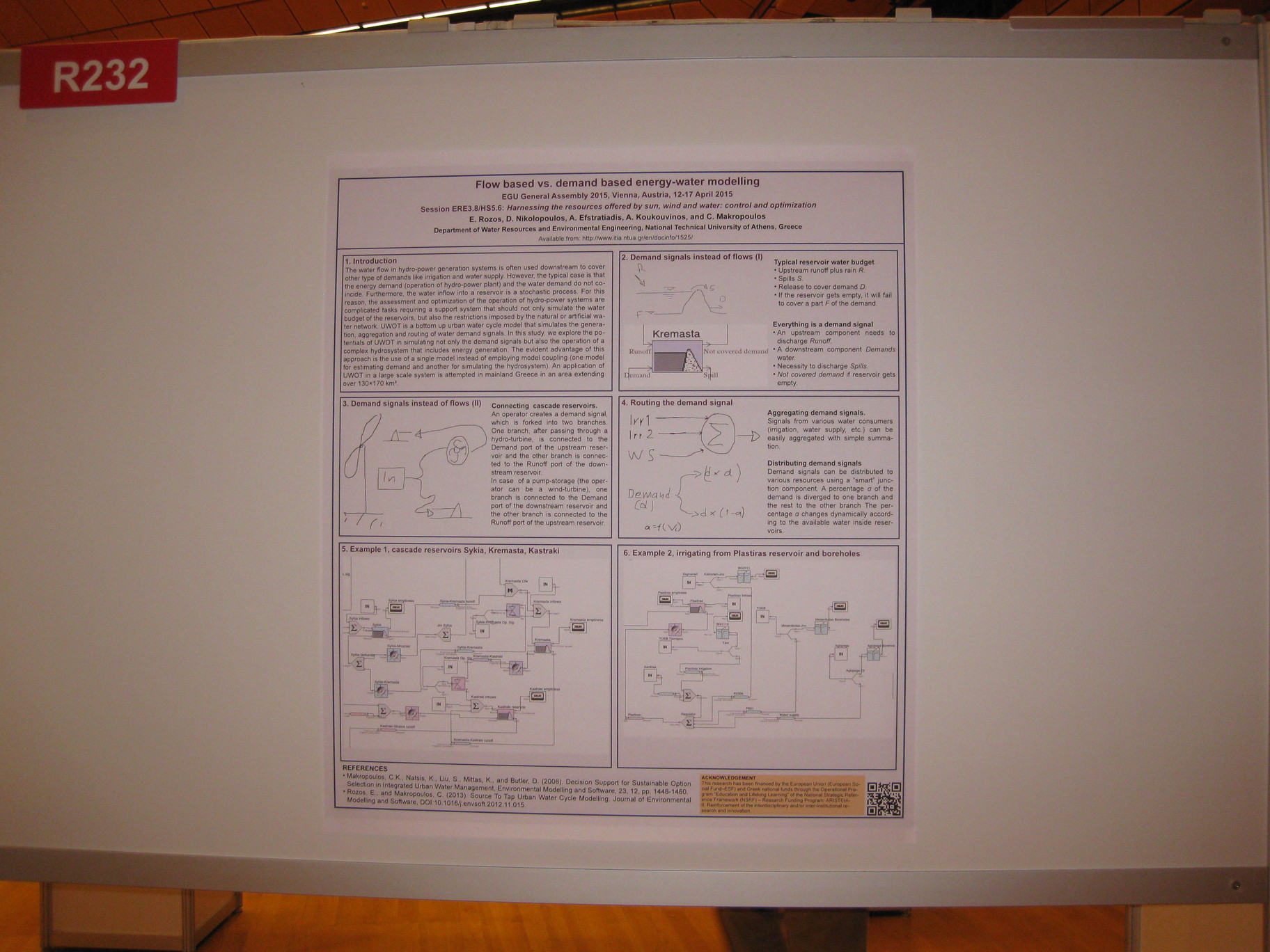
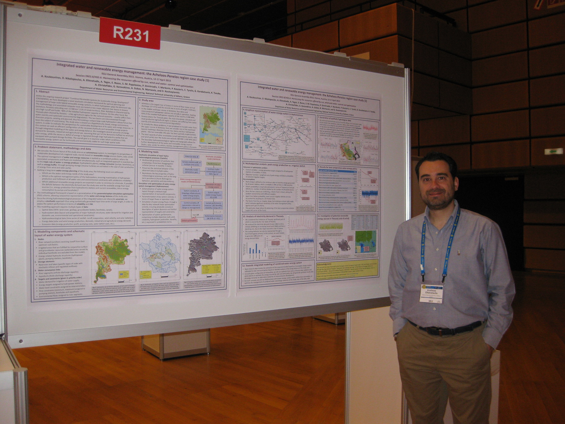
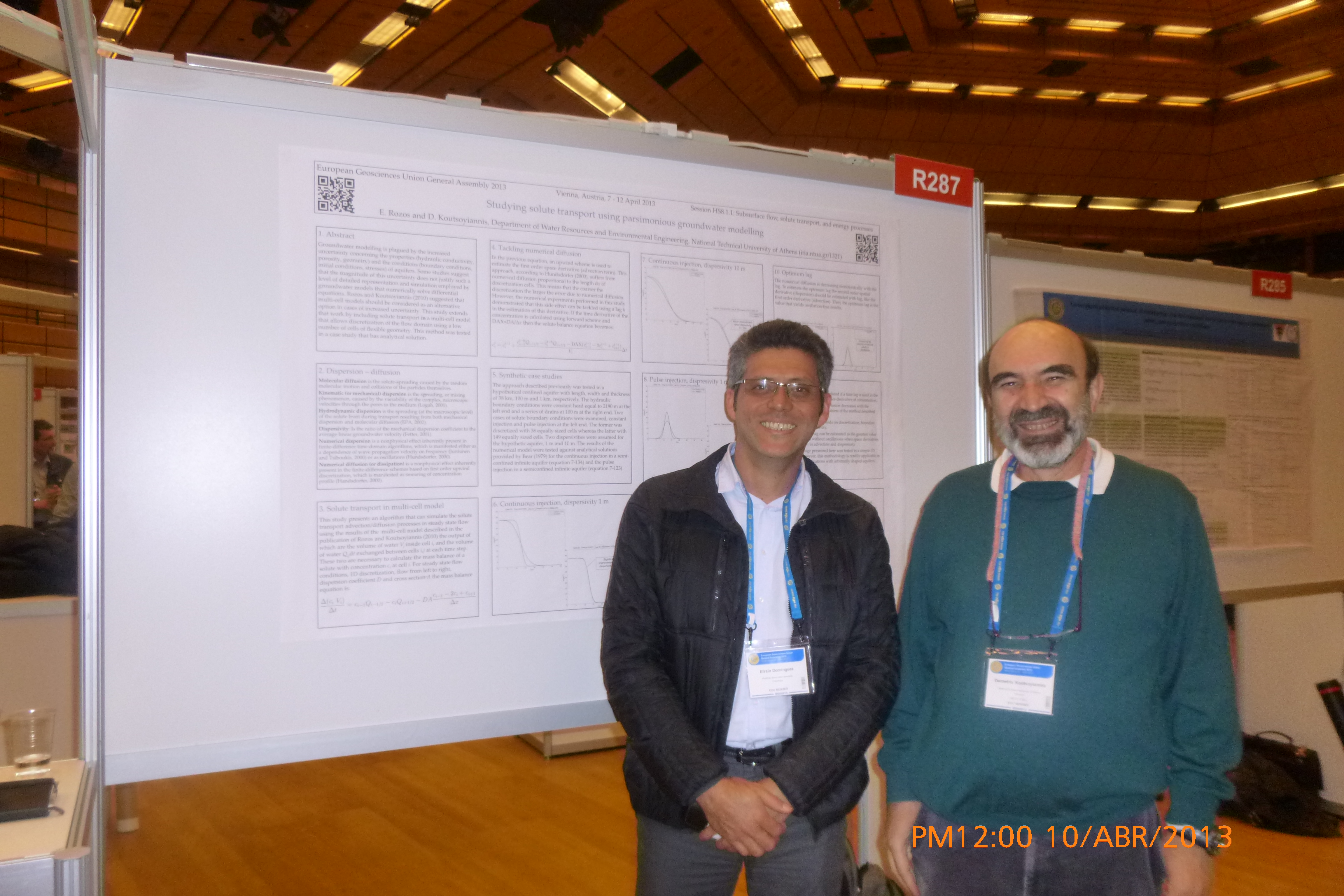