G.-Fivos Sargentis
Laboratory Teaching Staff, Civil Engineer, Dr. Engineer
G.-F.Sargentis@itia.ntua.gr
+30-2107722586
http://www.itia.ntua.gr/~fivos/
Participation in research projects
Participation as Researcher
- Maintenance, upgrading and extension of the Decision Support System for the management of the Athens water resource system
- Investigation of scenarios for the management and protection of the quality of the Plastiras Lake
Published work
Publications in scientific journals
- A. Efstratiadis, A. Zisos, A. Kolioukou, G.-F. Sargentis, P. Pagoulatou, E. Mandilaki, and N. Mamassis, Decarbonizing the Greek electricity system under the energy storage context: Between ambition and reality, Sustainability, 18 (15), 7588, doi:10.3390/su18157588, 2026.
- S. Sigourou, P. Dimitriadis, V. Pagana, A. Tsouni, T. Iliopoulou, G.-F. Sargentis, R. Ioannidis, D. Dimitrakopoulou, E. Chardavellas, N. Mamassis, D. Koutsoyiannis, and C. Kontoes, Developing an integrated methodology for flood-hazard assessment: application to the Pikrodafni River Basin (Attica, Greece), Frontiers in Built Environment, 12, 1768439, doi:10.3389/fbuil.2026.1768439, 2026.
- D. Koutsoyiannis, and G.-F. Sargentis, Trade-off between entropy and Gini Index in income distribution, Entropy, 28 (1), 35, doi:10.3390/e28010035, 2026.
- A. Tsouni, S. Sigourou, V. Pagana, M.-C. Tsoutsos, P. Dimitriadis, G.-F. Sargentis, T. Iliopoulou, R. Ioannidis, D. Dimitrakopoulou, E. Chardavellas, M.J. Alexopoulos, A. Koukouvinos, N. Mamassis, D. Koutsoyiannis, and C. Kontoes, Multiparameter flood risk assessment and management planning at high spatial resolution in the region of Attica, Greece, IEEE Journal of Selected Topics in Applied Earth Observations …, 18, 25966–25979, doi:10.1109/JSTARS.2025.3613569, 2025.
- G.-F. Sargentis, T. Iliopoulou, R. Ioannidis, M. Kougia, I. Benekos, P. Dimitriadis, A. Koukouvinos, D. Dimitrakopoulou, N. Mamassis, A. Tsouni, S. Sigourou, V. Pagana, C. Kontoes, and D. Koutsoyiannis, Technological Advances in Flood Risk Assessment and Related Operational Practices Since the 1970s: A Case Study in the Pikrodafni River of Attica, Water, 17(1) (112), doi:10.3390/w17010112, 2025.
- G.-F. Sargentis, N. Mamassis, and D. Koutsoyiannis, The multifaceted importance of mediterranean pine-tree forests to social cohesion. Energy, resin, grazing, and wildfire management in North Euboea, Greece, Natural Resources Conservation and Research, 7, 15 pages, 9962, doi:10.24294/nrcr9962, 2024.
- G.-F. Sargentis, R. Ioannidis, P. Dimitriadis, N. Malamos, O. Lyra, O. Kitsou, M. Kougia, N. Mamassis, and D. Koutsoyiannis, Energy Self-Sufficiency in Rural Areas; Case Study: North Euboea, Greece, Advances in Environmental and Engineering Research, 5 (4), 20 pages, doi:10.21926/aeer.2404025, 2024.
- G.-F. Sargentis, R. Ioannidis, N. Mamassis, V. Zoukos, and D. Koutsoyiannis, A review of the energy policy in Greece in the last 50 years and its implications for prosperity, Clean Energy and Sustainability, 2 (4), 10021, doi:10.70322/ces.2024.10021, 2024.
- G.-F. Sargentis, K. Moraiti, I. Benekos, R. Ioannidis, and N. Mamassis, Fast-Track Documentation of the Alterations on the Landscape, before and after a Natural Hazard—Case Study: North Euboea Greece before and after Storms Daniel and Elias, Rural and Regional Development, 2, 10016, doi:10.70322/rrd.2024.10016, 2024.
- K. Moraiti, S. Sigourou, P. Dimitriadis, R. Ioannidis, I. Benekos, T. Iliopoulou, O. Kitsou, N. Mamassis, D. Koutsoyiannis, and G.-F. Sargentis, Documenting the changing floodplain of Nileas Basin in North Euboea (Greece) before and after Storms Daniel and Elias, Rural and Regional Development, 2 (3), 10013, doi:10.35534/rrd.2024.10013, 2024.
- G.-F. Sargentis, N. Mamassis, O. Kitsou, and D. Koutsoyiannis, The role of technology in the water–energy–food nexus. A case study: Kerinthos, North Euboea, Greece, Frontiers in Water, 6, 1343344, doi:10.3389/frwa.2024.1343344, 2024.
- N. Wang, F. Sun, D. Koutsoyiannis, T. Iliopoulou, T. Wang, H. Wang, W. Liu, G.-F. Sargentis, and P. Dimitriadis, How can changes in the human-flood distance mitigate flood fatalities and displacements?, Geophysical Research Letters, 50 (20), e2023GL105064, doi:10.1029/2023GL105064, 2023.
- G.-F. Sargentis, and D. Koutsoyiannis, The function of money in water–energy–food and land nexus, Land, 12 (3), 669, doi:10.3390/land12030669, 2023.
- G.-F. Sargentis, R. Ioannidis, I. Bairaktaris, E. Frangedaki, P. Dimitriadis, T. Iliopoulou, D. Koutsoyiannis, and N. D. Lagaros, Wildfires vs. sustainable forest partitioning, Conservation, 2 (1), 195–218, doi:10.3390/conservation2010013, 2022.
- D. Markantonis, G.-F. Sargentis, P. Dimitriadis, T. Iliopoulou, A. Siganou, K. Moraiti, M. Nikolinakou, I. Meletopoulos, N. Mamassis, and D. Koutsoyiannis, Stochastic Evaluation of the Investment Risk by the Scale of Water Infrastructures-Case Study: The Municipality of West Mani (Greece), World, 4 (1), 1–20, doi:10.3390/world4010001, 2022.
- G.-F. Sargentis, D. Koutsoyiannis, A. N. Angelakis, J. Christy, and A.A. Tsonis, Environmental determinism vs. social dynamics: Prehistorical and historical examples, World, 3 (2), 357–388, doi:10.3390/world3020020, 2022.
- T. Iliopoulou, P. Dimitriadis, A. Siganou, D. Markantonis, K. Moraiti, M. Nikolinakou, I. Meletopoulos, N. Mamassis, D. Koutsoyiannis, and G.-F. Sargentis, Modern use of traditional rainwater harvesting practices: An assessment of cisterns’ water supply potential in West Mani, Greece, Heritage, 5 (4), 2944–2954, doi:10.3390/heritage5040152, 2022.
- G.-F. Sargentis, N. D. Lagaros, G.L. Cascella, and D. Koutsoyiannis, Threats in Water–Energy–Food–Land Nexus by the 2022 Military and Economic Conflict, Land, doi:10.3390/land11091569, 2022.
- R. Ioannidis, G.-F. Sargentis, and D. Koutsoyiannis, Landscape design in infrastructure projects - is it an extravagance? A cost-benefit investigation of practices in dams, Landscape Research, doi:10.1080/01426397.2022.2039109, 2022.
- G.-F. Sargentis, E. Frangedaki, M. Chiotinis, D. Koutsoyiannis, S. Camarinopoulos, A. Camarinopoulos, and N. D. Lagaros, 3D scanning/printing: a technological stride in sculpture, Technologies, doi:10.3390/technologies10010009, 2022.
- D. Koutsoyiannis, and G.-F. Sargentis, Entropy and wealth, Entropy, 23 (10), 1356, doi:10.3390/e23101356, 2021.
- P. Dimitriadis, T. Iliopoulou, G.-F. Sargentis, and D. Koutsoyiannis, Spatial Hurst–Kolmogorov Clustering, Encyclopedia, 1 (4), 1010–1025, doi:10.3390/encyclopedia1040077, 2021.
- G.-F. Sargentis, P. Siamparina, G.-K. Sakki, A. Efstratiadis, M. Chiotinis, and D. Koutsoyiannis, Agricultural land or photovoltaic parks? The water–energy–food nexus and land development perspectives in the Thessaly plain, Greece, Sustainability, 13 (16), 8935, doi:10.3390/su13168935, 2021.
- G.-F. Sargentis, T. Iliopoulou, P. Dimitriadis, N. Mamassis, and D. Koutsoyiannis, Stratification: An entropic view of society's structure, World, 2, 153–174, doi:10.3390/world2020011, 2021.
- G.-F. Sargentis, P. Dimitriadis, T. Iliopoulou, and D. Koutsoyiannis, A stochastic view of varying styles in art paintings, Heritage, 4, 21, doi:10.3390/heritage4010021, 2021.
- G.-F. Sargentis, R. Ioannidis, T. Iliopoulou, P. Dimitriadis, and D. Koutsoyiannis, Landscape planning of infrastructure through focus points’ clustering analysis. Case study: Plastiras artificial lake (Greece), Infrastructures, 6 (1), 12, doi:10.3390/infrastructures6010012, 2021.
- G.-F. Sargentis, T. Iliopoulou, S. Sigourou, P. Dimitriadis, and D. Koutsoyiannis, Evolution of clustering quantified by a stochastic method — Case studies on natural and human social structures, Sustainability, 12 (19), 7972, doi:10.3390/su12197972, 2020.
- G.-F. Sargentis, P. Dimitriadis, R. Ioannidis, T. Iliopoulou, E. Frangedaki, and D. Koutsoyiannis, Optimal utilization of water resources for local communities in mainland Greece (case study of Karyes, Peloponnese), Procedia Manufacturing, 44, 253–260, doi:10.1016/j.promfg.2020.02.229, 2020.
- G.-F. Sargentis, P. Dimitriadis, and D. Koutsoyiannis, Aesthetical issues of Leonardo Da Vinci’s and Pablo Picasso’s paintings with stochastic evaluation, Heritage, 3 (2), 283–305, doi:10.3390/heritage3020017, 2020.
- G.-F. Sargentis, P. Dimitriadis, R. Ioannidis, T. Iliopoulou, and D. Koutsoyiannis, Stochastic evaluation of landscapes transformed by renewable energy installations and civil works, Energies, 12 (4), 2817, doi:10.3390/en12142817, 2019.
- G.-F. Sargentis, R. Ioannidis, G. Karakatsanis, S. Sigourou, N. D. Lagaros, and D. Koutsoyiannis, The development of the Athens water supply system and inferences for optimizing the scale of water infrastructures, Sustainability, 11 (9), 2657, doi:10.3390/su11092657, 2019.
- K. Hadjibiros, A. Katsiri, A. Andreadakis, D. Koutsoyiannis, A. Stamou, A. Christofides, A. Efstratiadis, and G.-F. Sargentis, Multi-criteria reservoir water management, Global Network for Environmental Science and Technology, 7 (3), 386–394, doi:10.30955/gnj.000394, 2005.
- A. Christofides, A. Efstratiadis, D. Koutsoyiannis, G.-F. Sargentis, and K. Hadjibiros, Resolving conflicting objectives in the management of the Plastiras Lake: can we quantify beauty?, Hydrology and Earth System Sciences, 9 (5), 507–515, doi:10.5194/hess-9-507-2005, 2005.
Book chapters and fully evaluated conference publications
- G.-F. Sargentis, E. Frangedaki, T. Iliopoulou, P. Dimitriadis, and N. D. Lagaros, The Use of 3D Printed Models of the Landscape in Hydraulic Studies, Proceedings of the International Conferences on Digital Technology Driven Engineering 2024, Irbid - Jordan, 13 pages, Springer Nature, Jordan, 2025.
- G.-F. Sargentis, E. Frangedaki, T. Iliopoulou, P. Dimitriadis, and N. D. Lagaros, Fast-Track Modeling of the Landscape for Hydraulic Studies, Using Drones and Photogrammetry in Field Research, Proceedings of the International Conferences on Digital Technology Driven Engineering 2024, Irbid - Jordan, 16 pages, Springer Nature, Jordan, 2025.
- G.-F. Sargentis, R. Ioannidis, M. Kougia, I. Benekos, T. Iliopoulou, P. Dimitriadis, A. Koukouvinos, D. Dimitrakopoulou, N. Mamassis, A. Tsouni, S. Sigourou, V. Pagana, E. Frangedaki, N. D. Lagaros, C. Kontoes, and D. Koutsoyiannis, The technological evolution in flood risk estimation, Proceedings of the International Conferences on Digital Technology Driven Engineering 2024, Irbid - Jordan, 225–235, Springer Nature, 2025.
- G.-F. Sargentis, R. Ioannidis, M. Kougia, I. Benekos, T. Iliopoulou, P. Dimitriadis, A. Koukouvinos, D. Dimitrakopoulou, N. Mamassis, A. Tsouni, S. Sigourou, V. Pagana, E. Frangedaki, N. D. Lagaros, C. Kontoes, and D. Koutsoyiannis, Do floods attack cities or cities invade flood plains?, Proceedings of the International Conferences on Digital Technology Driven Engineering 2024, Irbid - Jordan, 216–224, Springer Nature, 2025.
- G.-F. Sargentis, M. Kougia, and N. D. Lagaros, Bridging Traditional Sculpture Methods with 3D Scanning/Printing, Proceedings of the International Conferences on Digital Technology Driven Engineering 2024, Irbid - Jordan, 18 pages, Springer Nature, Jordan, 2025.
- A. Tsouni, S. Sigourou, V. Pagana, M.-C. Tsoutsos, P. Dimitriadis, G.-F. Sargentis, T. Iliopoulou, R. Ioannidis, D. Dimitrakopoulou, E. Chardavellas, M.J. Alexopoulos, A. Koukouvinos, N. Mamassis, D. Koutsoyiannis, and C. Kontoes, Multi-parameter flood risk assessment and management planning at high spatial resolution in the region of Attica, Greece, IGARSS 2024 - 2024 IEEE International Geoscience and Remote Sensing Symposium, Athens, Greece, doi:10.1109/IGARSS53475.2024.10642600, IEEE, 2024.
- A. Christofides, T. Iliopoulou, P. Dimitriadis, D. Koutsoyiannis, A. Koukouvinos, V. Soulis, G.-F. Sargentis, C. Myriounis, and A. Christoforou, Enhydris: Software for the geographic - hydrological - hydraulic visualization and data management for hydrosystems: Application on the water supply system of Athens, Proceedings of 4th Hellenic Conference on Dams and Reservoirs, War Museum Athens, 323–331, Hellenic Commission on Large Dams, Athens, 2024.
- R. Ioannidis, G.-F. Sargentis, A. Efstratiadis, N. Mamassis, and D. Koutsoyiannis, The challenge of integrating civil infrastructure acrosss landscapes and the importance of the architectural design of dams, Proceedings of 4th Hellenic Conference on Dams and Reservoirs, War Museum Athens, 127–137, Hellenic Commission on Large Dams, Athens, 2024.
- D. Koutsoyiannis, and G.-F. Sargentis, Market empire dead end, Reflections Without Custody – In Memory of Themistocles Xanthopoulos, NTUA Rector 1997-2003, edited by D. Koutsoyiannis, N. D. Lagaros, and A.G. Boudouvis, 99–123, National Technical University of Athens Press – National Technical University of Athens, Athens, 2024.
- G.-F. Sargentis, R. Ioannidis, M. Chiotinis, P. Dimitriadis, and D. Koutsoyiannis, Aesthetical issues with stochastic evaluation, Data Analytics for Cultural Heritage, edited by A. Belhi, A. Bouras, A.K. Al-Ali, and A.H. Sadka, doi:10.1007/978-3-030-66777-1_8, Springer, 2021.
- G.-F. Sargentis, K. Hadjibiros, and A. Christofides, Plastiras lake: the impact of water level on the aesthetic value of landscape, Proceedings of the 9th International Conference on Environmental Science and Technology (9CEST), Rhodes, B, 817–824, Department of Environmental Studies, University of the Aegean, 2005.
- K. Hadjibiros, A. Katsiri, A. Andreadakis, D. Koutsoyiannis, A. Stamou, A. Christofides, A. Efstratiadis, and G.-F. Sargentis, Multi-criteria reservoir water management, Proceedings of the 9th International Conference on Environmental Science and Technology (9CEST), Rhodes, A, 535–543, Department of Environmental Studies, University of the Aegean, 2005.
- K. Hadjibiros, D. Koutsoyiannis, A. Katsiri, A. Stamou, A. Andreadakis, G.-F. Sargentis, A. Christofides, A. Efstratiadis, and A. Valassopoulos, Management of water quality of the Plastiras reservoir, 4th International Conference on Reservoir Limnology and Water Quality, Ceske Budejovice, Czech Republic, doi:10.13140/RG.2.1.4872.4723, 2002.
- G.-F. Sargentis, Detecting universal archetypes of "culture heroes" Dayu and Hercules, 5th International Seminar on Water Culture Water and Human Ingenuity: Enduring inspirations of Dayu, 18 pages, China, November 2025.
Conference publications and presentations with evaluation of abstract
- St Kopelia, N. Tepetidis, J N Tzortzi, G.-F. Sargentis, and R. Ioannidis, Integrating participatory perception-mapping data and stochastic image analysis for urban landscape assessment, European Geosciences Union General Assembly 2026, Vienna, Austria & Online, 4 pages, European Geosciences Union, Vienna, 2026.
- N Papadodimas, G D Laoutaris, N. Mamassis, and G.-F. Sargentis, Reverse Engineering for the Chronology of Medieval Aqueducts: A Case Study of the Holy Monastery of Dochiariou, Mount Athos, European Geosciences Union General Assembly 2026, Vienna, Austria & Online, 20 pages, doi:https://doi.org/10.5194/egusphere-egu26-14910, European Geosciences Union, Vienna, 2026.
- M Maravelakis, T. Iliopoulou, and G.-F. Sargentis, The Water-Energy-Food Nexus in Naxos Island: Enhancing Self-Sufficiency Through Traditional Techniques, European Geosciences Union General Assembly 2026, Vienna, Austria & Online, 23 pages, doi:https://doi.org/10.5194/egusphere-egu26-12878, European Geosciences Union, Vienna, 2026.
- P. Pagoulatou, E. Mandilaki, T. Iliopoulou, G.-F. Sargentis, and R. Ioannidis, Stochastic Investigation of Solar and Wind Processes for Renewable Energy Storage in Greece, European Geosciences Union General Assembly 2026, Vienna, Austria & Online, 23 pages, doi:https://doi.org/10.5194/egusphere-egu26-9942, European Geosciences Union, Vienna, 2026.
- M A Angelidis, I. Arvanitidis, R. Ioannidis, and G.-F. Sargentis, Spatial Analysis of Desalination Energy Demand in Greece: Feasibility Zones from the coastline for Water-Energy Planning, European Geosciences Union General Assembly 2026, Vienna, Austria & Online, 21 pages, doi:https://doi.org/10.5194/egusphere-egu26-8222, 2026, European Geosciences Union, Vienna, 2026.
- I. Arvanitidis, and G.-F. Sargentis, Spatial Indicators of Dynamic Self-Sufficiency and Resilience in the Water–Energy–Food Nexus Case study: Small Rural Village in North Euboea, Greece, European Geosciences Union General Assembly 2026, Vienna, Austria & Online, 19 pages, doi:https://doi.org/10.5194/egusphere-egu26-14761, 2026, European Geosciences Union, Vienna, 2026.
- I F Bozanas, G.-F. Sargentis, and T. Iliopoulou, European snow dynamics and changing patterns under climate variability, European Geosciences Union General Assembly 2026, Vienna, Austria & Online, 22 pages, doi:https://doi.org/10.5194/egusphere-egu26-10737, European Geosciences Union, Vienna, 2026.
- K Maravitsas, P Makris, T Bousoula, G.-F. Sargentis, and T. Iliopoulou, Comparison of temporal changes in aridity in European and African regions, European Geosciences Union General Assembly 2026, Vienna, Austria & Online, 20 pages, doi:https://doi.org/10.5194/egusphere-egu26-9974, European Geosciences Union, Vienna, 2026.
- D. Saperopoulou, V. Kouzelis, G.-F. Sargentis, A. Efstratiadis, and N. Tepetidis, Social prosperity and natural resource management: Stochastic evaluation of two operational paradigms of pumped-storage hydropower in North Euboea under renewable energy integration and energy market dynamics, European Geosciences Union General Assembly 2026, Vienna, Austria & Online, EGU26-8099, doi:10.5194/egusphere-egu26-8099, European Geosciences Union, 2026.
- D. Dimitrakopoulou, P. Dimitriadis, R. Ioannidis, G.-F. Sargentis, E. Chardavellas, M.J. Alexopoulos, S. Sigourou, V. Pagana, A. Tsouni, N. Mamassis, D. Koutsoyiannis, and C. Kontoes, The importance of citizens’ engagement in the implementation of civil works for the mitigation of natural disasters with focus on flood risk in Attica Prefecture (Greece), European Geosciences Union General Assembly 2024, Vienna, Austria & Online, 14 pages, EGU24-12686, doi:10.5194/egusphere-egu24-12686, European Geosciences Union, Vienna, 2024.
- M. Kougia, S. Sigourou, P. Dimitriadis, R. Ioannidis, A. Tsouni, G.-F. Sargentis, D. Dimitrakopoulou, E. Chardavellas, N. Mamassis, D. Koutsoyiannis, and C. Kontoes, Modern vs traditional mapping methods for flood risk estimation: A case study for the river Pikrodafni, Athens, Greece, European Geosciences Union General Assembly 2024, Vienna, Austria & Online, 16 pages, EGU24-6459, doi:10.5194/egusphere-egu24-6459, European Geosciences Union, Vienna, 2024.
- P. Dimitriadis, D. Koutsoyiannis, T. Iliopoulou, and G.-F. Sargentis, Precipitation changes in Greece over the past century; what type of stochastic description should we use?, European Geosciences Union General Assembly 2024, Vienna, Austria & Online, 9 pages, EGU24-18860, doi:10.5194/egusphere-egu24-18860, European Geosciences Union, Vienna, 2024.
- A. Tsouni, S. Sigourou, P. Dimitriadis, V. Pagana, T. Iliopoulou, G.-F. Sargentis, R. Ioannidis, E. Chardavellas, D. Dimitrakopoulou, N. Mamassis, D. Koutsoyiannis, and C. Kontoes, Multi-parameter flood risk assessment towards efficient flood management in highly dense urban river basins in the Region of Attica, Greece, European Geosciences Union General Assembly 2023, Vienna, Austria & Online, EGU23-12624, doi:10.5194/egusphere-egu23-12624, 2023.
- G. Kirkmalis, G.-F. Sargentis, R. Ioannidis, D. Markantonis, T. Iliopoulou, P. Dimitriadis, N. Mamassis, and D. Koutsoyiannis, Fertilizers as batteries and regulators in the global Water-Energy-Food equilibrium, European Geosciences Union General Assembly 2023, Vienna, Austria & Online, EGU23-11915, doi:10.5194/egusphere-egu23-11915, 2023.
- S. Sigourou, A. Tsouni, V. Pagana, G.-F. Sargentis, P. Dimitriadis, R. Ioannidis, E. Chardavellas, D. Dimitrakopoulou, N. Mamassis, D. Koutsoyiannis, and C. Kontoes, An advanced methodology for field visits towards efficient flood management on building block level, European Geosciences Union General Assembly 2023, Vienna, Austria & Online, EGU23-16168, doi:10.5194/egusphere-egu23-16168, 2023.
- D. Dimitrakopoulou, R. Ioannidis, P. Dimitriadis, T. Iliopoulou, G.-F. Sargentis, E. Chardavellas, N. Mamassis, and D. Koutsoyiannis, Public involvement in the design and implementation of infrastructure projects, European Geosciences Union General Assembly 2023, Vienna, Austria & Online, EGU23-16478, doi:10.5194/egusphere-egu23-16478, 2023.
- D. Markantonis, P. Dimitriadis, G.-F. Sargentis, T. Iliopoulou, N. Mamassis, and D. Koutsoyiannis, Estimating the risk of large investments using Hurst-Kolmogorov dynamics in interest rates, European Geosciences Union General Assembly 2023, Vienna, Austria & Online, EGU23-14416, doi:10.5194/egusphere-egu23-14416, 2023.
- P. Dimitriadis, M. Kougia, G.-F. Sargentis, T. Iliopoulou, N. Mamassis, and D. Koutsoyiannis, Violent land terrain alterations and their impacts on water management; Case study: North Euboea, European Geosciences Union General Assembly 2023, Vienna, Austria & Online, EGU23-13318, doi:10.5194/egusphere-egu23-13318, 2023.
- D. Dimitrakopoulou, R. Ioannidis, G.-F. Sargentis, P. Dimitriadis, T. Iliopoulou, E. Chardavellas, S. Vavoulogiannis, N. Mamassis, and D. Koutsoyiannis, Social uncertainty in flood risk: field research, citizens’ engagement, institutions' collaboration, IAHS 100th Anniversary – 11th IAHS-AISH Scientific Assembly 2022, Montpellier, France, IAHS2022-351, International Association of Hydrological Sciences, 2022.
- G.-F. Sargentis, I. Meletopoulos, T. Iliopoulou, P. Dimitriadis, E. Chardavellas, D. Dimitrakopoulou, A. Siganou, D. Markantonis, K. Moraiti, K. Kouros, M. Nikolinakou, and D. Koutsoyiannis, Modelling water needs; from past to present. Case study: The Municipality of Western Mani, IAHS 100th Anniversary – 11th IAHS-AISH Scientific Assembly 2022, Montpellier, France, IAHS2022-400, International Association of Hydrological Sciences, 2022.
- P. Dimitriadis, T. Iliopoulou, G.-F. Sargentis, and D. Koutsoyiannis, Spatial and temporal long-range dependence in the scale domain, EGU General Assembly 2022, Vienna, Austria & Online, EGU22-13051, doi:10.5194/egusphere-egu22-13051, European Geosciences Union, 2022.
- D. Markantonis, A. Siganou, K. Moraiti, M. Nikolinakou, G.-F. Sargentis, P. Dimitriadis, M. Chiotinis, T. Iliopoulou, N. Mamassis, and D. Koutsoyiannis, Determining optimal scale of water infrastructure considering economical aspects with stochastic evaluation – Case study at the Municipality of Western Mani, EGU General Assembly 2022, Vienna, Austria & Online, EGU22-3039, doi:10.5194/egusphere-egu22-3039, European Geosciences Union, 2022.
- K. Moraiti, D. Markantonis, M. Nikolinakou, A. Siganou, G.-F. Sargentis, T. Iliopoulou, P. Dimitriadis, I. Meletopoulos, N. Mamassis, and D. Koutsoyiannis, Optimizing water infrastructure solutions for small-scale distributed settlements – Case study at the Municipality of Western Mani., EGU General Assembly 2022, Vienna, Austria & Online, EGU22-3055, doi:10.5194/egusphere-egu22-3055, European Geosciences Union, 2022.
- M. Nikolinakou, K. Moraiti, A. Siganou, D. Markantonis, G.-F. Sargentis, T. Iliopoulou, P. Dimitriadis, I. Meletopoulos, N. Mamassis, and D. Koutsoyiannis, Investigating the water supply potential of traditional rainwater harvesting techniques used – A case study for the Municipality of Western Mani, EGU General Assembly 2022, Vienna, Austria & Online, European Geosciences Union, 2022.
- A. Siganou, M. Nikolinakou, D. Markantonis, K. Moraiti, G.-F. Sargentis, T. Iliopoulou, P. Dimitriadis, M. Chiotinis, N. Mamassis, and D. Koutsoyiannis, Stochastic simulation of hydrological timeseries for data scarce regions - Case study at the Municipality of Western Mani, EGU General Assembly 2022, Vienna, Austria & Online, EGU22-3086, doi:10.5194/egusphere-egu22-3086, European Geosciences Union, 2022.
- I. Arvanitidis, Μ. Diamanta, G.-F. Sargentis, T. Iliopoulou, P. Dimitriadis, and D. Koutsoyiannis, Identifying links between hydroclimatic variability and economical components using stochastic methods, EGU General Assembly 2022, Vienna, Austria & Online, EGU22-5944, doi:10.5194/egusphere-egu22-5944, European Geosciences Union, 2022.
- S. Vrettou, A. Trompouki, T. Iliopoulou, G.-F. Sargentis, P. Dimitriadis, and D. Koutsoyiannis, Investigation of stochastic similarities between wind and waves and their impact on offshore structures, EGU General Assembly 2022, Vienna, Austria & Online, EGU22-3082, doi:10.5194/egusphere-egu22-3082, European Geosciences Union, 2022.
- A. Trompouki, S. Vrettou, G.-F. Sargentis, P. Dimitriadis, T. Iliopoulou, and D. Koutsoyiannis, Investigation of the spatial correlation structure of 2-D wave fields at the Aegean Sea, EGU General Assembly 2022, Vienna, Austria & Online, EGU22-3083, doi:10.5194/egusphere-egu22-3083, European Geosciences Union, 2022.
- E. Manta, R. Ioannidis, G.-F. Sargentis, and A. Efstratiadis, Aesthetic evaluation of wind turbines in stochastic setting: Case study of Tinos island, Greece, European Geosciences Union General Assembly 2020, Geophysical Research Abstracts, Vol. 22, Vienna, EGU2020-5484, doi:10.5194/egusphere-egu2020-5484, 2020.
- E. Frangedaki, and G.-F. Sargentis, Optimizing engineering aspects of earth constructions.The earth as "common" material., European Geosciences Union General Assembly 2019, Geophysical Research Abstracts, Vol. 21, Vienna, EGU2019-11412-1, European Geosciences Union, 2019.
- G.-F. Sargentis, E. Frangedaki, P. Dimitriadis, and D. Koutsoyiannis, Development of a web platform of knowledge exchange for optimal selection of building materials based on ecological criteria, European Geosciences Union General Assembly 2019, Geophysical Research Abstracts, Vol. 21, Vienna, EGU2019-10395, European Geosciences Union, 2019.
- Μ. Sako, E. Tsoli, R. Ioannidis, E. Frangedaki, G.-F. Sargentis, and D. Koutsoyiannis, Optimizing the size of Hilarion dam with technical, economical and environmental parameters, European Geosciences Union General Assembly 2019, Geophysical Research Abstracts, Vol. 21, Vienna, EGU2019-15297, European Geosciences Union, 2019.
- R. Ioannidis, P. Dimitriadis, G.-F. Sargentis, E. Frangedaki, T. Iliopoulou, and D. Koutsoyiannis, Stochastic similarities between hydrometeorogical and art processes for optimizing architecture and landscape aesthetic parameters, European Geosciences Union General Assembly 2019, Geophysical Research Abstracts, Vol. 21, Vienna, EGU2019-11403, European Geosciences Union, 2019.
- G.-F. Sargentis, R. Ioannidis, G. Karakatsanis, and D. Koutsoyiannis, The scale of infrastructures as a social decision. Case study: dams in Greece, European Geosciences Union General Assembly 2018, Geophysical Research Abstracts, Vol. 20, Vienna, EGU2018-17082, European Geosciences Union, 2018.
- G.-F. Sargentis, P. Dimitriadis, T. Iliopoulou, R. Ioannidis, and D. Koutsoyiannis, Stochastic investigation of the Hurst-Kolmogorov behaviour in arts, European Geosciences Union General Assembly 2018, Geophysical Research Abstracts, Vol. 20, Vienna, EGU2018-17740-1, European Geosciences Union, 2018.
- A. Efstratiadis, D. Koutsoyiannis, K. Hadjibiros, A. Andreadakis, A. Stamou, A. Katsiri, G.-F. Sargentis, and A. Christofides, A multicriteria approach for the sustainable management of the Plastiras reservoir, Greece, EGS-AGU-EUG Joint Assembly, Geophysical Research Abstracts, Vol. 5, Nice, doi:10.13140/RG.2.2.23631.48801, European Geophysical Society, 2003.
- S. Sigourou, V. Pagana, P. Dimitriadis, A. Tsouni, T. Iliopoulou, G.-F. Sargentis, R. Ioannidis, E. Chardavellas, D. Dimitrakopoulou, N. Mamassis, C. Kontoes, and D. Koutsoyiannis, Flood risk assessment in the region of Attica, 9th International Conference on Civil Protection & New Technologies - Safe Thessaloniki 2022, Thessaloniki, Greece, September 2022.
- S. Sigourou, V. Pagana, P. Dimitriadis, A. Tsouni, T. Iliopoulou, G.-F. Sargentis, R. Ioannidis, E. Chardavellas, D. Dimitrakopoulou, N. Mamassis, C. Kontoes, and D. Koutsoyiannis, Proposed methodology for urban flood-risk assessment at river-basin level: the case study of the Pikrodafni river basin in Athens, Greece, Global Flood Partnership 2022 Annual Meeting, Leeds, UK, September 2022.
Presentations and publications in workshops
- D. Koutsoyiannis, T. Iliopoulou, and G.-F. Sargentis, K-moments and their application to ombrian modelling, Invited lecture, Università di Bologna, Bologna, 2026.
- N. Mamassis, G.-F. Sargentis, and D. Koutsoyiannis, Temporal evolution of the electric energy mix in Greece: From development to dependence, 11th Conference: "Theories, research and actions for the regeneration of mountainous and isolated areas", Metsovo, 19 pages, Metsovo, September 2025.
- G.-F. Sargentis, P. Defteraios, N. D. Lagaros, and N. Mamassis, Values and costs in history, Stuff we don't mention in the normal course of studies, Rovies, National Technical University of Athens (NTUA), 2023.
- G.-F. Sargentis, R. Ioannidis, E. Frangedaki, P. Dimitriadis, T. Iliopoulou, D. Koutsoyiannis, and N. D. Lagaros, Wildfires, Stuff we don't mention in the normal course of studies, Rovies, National Technical University of Athens (NTUA), 2023.
- D. Koutsoyiannis, and G.-F. Sargentis, Entropy and Wealth_1, Stuff we don't mention in the normal course of studies, Rovies, National Technical University of Athens (NTUA), 2023.
- N. Mamassis, and G.-F. Sargentis, [No English title available], Stuff we don't mention in the normal course of studies, Rovies, National Technical University of Athens (NTUA), 2023.
- G.-F. Sargentis, Τhe feasibility of energy projects, Stuff we don't mention in the normal course of studies, Rovies, National Technical University of Athens (NTUA), 2023.
- G.-F. Sargentis, Wildfires. Case study: The fire in Euboea 2021, Stuff we don't mention in the normal course of studies, Rovies, National Technical University of Athens (NTUA), 2023.
- G.-F. Sargentis, Feasibility of the RE infrastructures: The role of beauty, Stuff we don't mention in the normal course of studies, Rovies, National Technical University of Athens (NTUA), 2023.
- G.-F. Sargentis, [No English title available], Stuff we don't mention in the normal course of studies, Rovies, National Technical University of Athens (NTUA), 2023.
- G.-F. Sargentis, [No English title available], Stuff we don't mention in the normal course of studies, Rovies, National Technical University of Athens (NTUA), 2023.
- A. Tsouni, S. Sigourou, V. Pagana, D. Koutsoyiannis, N. Mamassis, A. Koukouvinos, P. Dimitriadis, T. Iliopoulou, G.-F. Sargentis, R. Ioannidis, D. Dimitrakopoulou, E. Chardavellas, S. Vavoulogiannis, and V. Kyriakouli, Flood risk assessment in the Pikrodafni basin, Presentation of results for the 1st Phase of the Program Agreement between Attica Regional Authority and NOA, Athens, National Observatory of Athens, 2022.
Various publications
- G.-F. Sargentis, The dynamics of rainwater in Naxos, 15 pages, National Technical University of Athens, Naxos, October 2025.
- D. Koutsoyiannis, G.-F. Sargentis, N. Mamassis, and T. Iliopoulou, The importance of water in the historical development of science, Presentation for the Nishan Forum on Water Culture, doi:10.13140/RG.2.2.28165.67047, Qufu, China, July 2025.
- G.-F. Sargentis, Does the water go to the city or the city to the water?, 43 pages, Athens, 2025.
- G.-F. Sargentis, National Technical University of Athens, Infrastructure Evolution (up to 2010), 34 pages, National Technical University of Athens, Athens, 2025.
- G.-F. Sargentis, Prometheus Pyrphorοs, 12 pages, National Technical University of Athens, Athens, 2025.
- G.-F. Sargentis, Hercules of Farneze, 13 pages, National Technical University of Athens, Athens, 2025.
- G.-F. Sargentis, The Averof building, 40 pages, National Technical University of Athens, Athens, 2025.
- G.-F. Sargentis, 700-bed hostels Zografou University Campus, 33 pages, National Technical University of Athens, Athens, 2025.
- G.-F. Sargentis, and R. Ioannidis, The effect of wind turbines in the landscape, Department of Water Resources and Environmental Engineering – National Technical University of Athens, 2023.
- G.-F. Sargentis, The feasibility of Renewable Energy projects, Department of Water Resources and Environmental Engineering – National Technical University of Athens, 2023.
- N. Mamassis, and G.-F. Sargentis, Instructions for the presentation in laboratory of humanitarian studies (section history), Department of Water Resources and Environmental Engineering – National Technical University of Athens, 2023.
- G.-F. Sargentis, The role of money in water-energy and food nexus, Department of Water Resources and Environmental Engineering – National Technical University of Athens, 2023.
- N. Mamassis, and G.-F. Sargentis, The subjectivity of money, Department of Water Resources and Environmental Engineering – National Technical University of Athens, 2023.
- N. Mamassis, and G.-F. Sargentis, Money in history, Department of Water Resources and Environmental Engineering – National Technical University of Athens, 2023.
- N. Mamassis, and G.-F. Sargentis, The role of food in prosperity, Department of Water Resources and Environmental Engineering – National Technical University of Athens, 2023.
- N. Mamassis, and G.-F. Sargentis, The role of energy in prosperity, Department of Water Resources and Environmental Engineering – National Technical University of Athens, 2023.
- N. Mamassis, and G.-F. Sargentis, The role of water in prosperity, Department of Water Resources and Environmental Engineering – National Technical University of Athens, 2023.
- G.-F. Sargentis, The role of water-energy-food nexus in prosperity, Department of Water Resources and Environmental Engineering – National Technical University of Athens, 2023.
- N. Mamassis, and G.-F. Sargentis, Overpopulation and environmental determinism, Department of Water Resources and Environmental Engineering – National Technical University of Athens, 2023.
- N. Mamassis, and G.-F. Sargentis, The time as experience, 2023.
- G.-F. Sargentis, Which are the sources of our research and why are important?, Department of Water Resources and Environmental Engineering – National Technical University of Athens, 2023.
- G.-F. Sargentis, The civil engineer. Technology for prosperity, Ionios School, Athens, 2023.
- G.-F. Sargentis, and N. Mamassis, Water collection in houses and complexes– Guidelines for the design in small scales, 75–80, 2021.
- G.-F. Sargentis, The role of technology in the water, energy and food grid, Department of Water Resources and Environmental Engineering – National Technical University of Athens.
Books
- D. Koutsoyiannis, D. Liatis, L. Lazaridis, K. Lymperis, S. Kavounidis, S. Sthathopoulos, S. Lampropoulos, N. Moutafis, J. Stefanakos, C. Memos, P. Marinos, D. Ioakeim, C.P. Kostopanayiotis, A. Mizara, and G.-F. Sargentis, 130 Years School of Civil Engineering NTUA: Alma Mater of Greek Technology, Kleidarithmos, Athens, 2018.
Educational notes
- G.-F. Sargentis, and T. Iliopoulou, Water-Energy and Food nexus. Methodology of research, questions and databases, 14 pages, Athens, September 2025.
- G.-F. Sargentis, Technical projects and changes in the landscape, 82 pages, Athens, October 2024.
- D. Koutsoyiannis, M. Pantazidou, N. Mamassis, G.-F. Sargentis, P. Thanopoulos, S. Lampropoulos, D Vamvatsikos, and K. Hadjibiros, Lecture Notes for the Laboratory on Humanities, School of Civil Engineering – National Technical University of Athens, Athens, 2020.
- G.-F. Sargentis, Lecture notes on Environmental Impacts: The aesthetic element at dams, 28 pages, Department of Water Resources and Environmental Engineering – National Technical University of Athens, October 2019.
- A. Efstratiadis, G.-F. Sargentis, and N. Mamassis, Lecture notes on Environmental Impacts: Analysis of environmental impacts from large hydraulic structures, 37 pages, Department of Water Resources and Environmental Engineering – National Technical University of Athens, October 2019.
- A. Christofides, A. Efstratiadis, and G.-F. Sargentis, Presentation of the research project "Investigation of scenarios for the management and protection of the quality of the Plastiras Lake", 79 pages, 1 April 2003.
Academic works
- G.-F. Sargentis, Issues of Prosperity: Stochastic evaluation of data related to environment, infrastructures, economy and society, PhD thesis, Department of Water Resources and Environmental Engineering – National Technical University of Athens, June 2022.
- G.-F. Sargentis, The esthetic element in water, hydraulic works and dams, Diploma thesis, Department of Water Resources, Hydraulic and Maritime Engineering – National Technical University of Athens, Athens, 1998.
Research reports
- K. Hadjibiros, D. Koutsoyiannis, A. Andreadakis, A. Katsiri, A. Stamou, A. Valassopoulos, A. Efstratiadis, I. Katsiris, M. Kapetanaki, A. Koukouvinos, N. Mamassis, K. Noutsopoulos, G.-F. Sargentis, and A. Christofides, Overview report, Investigation of scenarios for the management and protection of the quality of the Plastiras Lake, Report 1, 23 pages, Department of Water Resources, Hydraulic and Maritime Engineering – National Technical University of Athens, Athens, March 2002.
- G.-F. Sargentis, and A. Christofides, The landscape, Investigation of scenarios for the management and protection of the quality of the Plastiras Lake, Report 4, 73 pages, Department of Water Resources, Hydraulic and Maritime Engineering – National Technical University of Athens, Athens, March 2002.
Miscellaneous works
- G.-F. Sargentis, Art and Infrastructures, 84 pages, National Technical University of Athens, Athens, December 2025.
- G.-F. Sargentis, The synergies of the water-energy and food nexus, Agrenda, 1033, August 2025.
Details on research projects
Participation as Researcher
-
Maintenance, upgrading and extension of the Decision Support System for the management of the Athens water resource system
Duration: October 2008–November 2011
Budget: €72 000
Project director: N. Mamassis
Principal investigator: D. Koutsoyiannis
This research project includes the maintenance, upgrading and extension of the Decision Support System that developed by NTUA for EYDAP in the framework of the research project “Updating of the supervision and management of the water resources’ system for the water supply of the Athens’ metropolitan area”. The project is consisted of the following parts: (a) Upgrading of the Data Base, (b)Upgrading and extension of hydrometeorological network, (c) upgrading of the hydrometeorological data process software, (d) upgrading and extension of the Hydronomeas software, (e) hydrological data analysis and (f) support to the preparation of the annual master plans
-
Investigation of scenarios for the management and protection of the quality of the Plastiras Lake
Duration: May 2001–January 2002
Commissioned by:
- Prefectural Government of Karditsa
- Municipality of Karditsa
Contractor: Department of Water Resources, Hydraulic and Maritime Engineering
Project director: K. Hadjibiros
Principal investigator: D. Koutsoyiannis
To protect the Plastiras Lake, a high quality of the natural landscape and a satisfactory water quality must be ensured, the conflicting water uses and demands must be arranged and effective water management practices must be established. To this aim, the hydrology of the catchment is investigated, the geographical, meteorological and water power data are collected and processed, the water balance is studied and a stochastic model is constructed to support the study of alternative management scenarios. In addition, an analysis of the natural landscape is performed and the negative influences (e.g. dead tries) are determined and quantified using GIS. Furthermore, the water quality parameters are evaluated, the water quality state is assessed, the quantitative targets are determined, the pollution sources are identified and measures for the reduction of pollution are studied using a hydrodynamic model with emphasis on the nutrient status. Based on the results of these analyses, scenarios of safe water release are suggested.
Published work in detail
Publications in scientific journals
-
A. Efstratiadis, A. Zisos, A. Kolioukou, G.-F. Sargentis, P. Pagoulatou, E. Mandilaki, and N. Mamassis, Decarbonizing the Greek electricity system under the energy storage context: Between ambition and reality, Sustainability, 18 (15), 7588, doi:10.3390/su18157588, 2026.
Decarbonization has been set as the ultimate target of the European energy policy, and, under this frame, Greece has substantially reformed its electricity mix over the last two decades. Yet, the rapid transition of the country’s electricity production system towards a model that strongly relies on non-controllable renewables, without improving its energy storage means, has caused several adverse impacts that reasonably raise serious concerns about its sustainability. Further questions arise when accounting for the projections and underlying assumptions reported in the National Energy and Climate Plan. In this vein, key policy, societal, technical, sustainability and science issues are discussed, involving the challenges, perspectives and potential drawbacks of Greece’s long-term energy planning . To reveal the critical role of storage, a toy simulation-optimization model is applied at the national scale to evaluate several scenarios of wind and solar P/V development under the premise of a theoretically fully decarbonized mix. This allows the exploration of trade-offs between energy storage and power capacity needs against key performance metrics (frequency and quantity of deficits and percentage of rejected renewable energy). Preliminary feasibility issues are also highlighted by considering alternative configurations of pumped hydropower storage units and associating their approximative investment costs with scale and geometry.
Full text: http://www.itia.ntua.gr/en/getfile/2632/1/documents/sustainability-4444768_R1.pdf (1353 KB)
-
S. Sigourou, P. Dimitriadis, V. Pagana, A. Tsouni, T. Iliopoulou, G.-F. Sargentis, R. Ioannidis, D. Dimitrakopoulou, E. Chardavellas, N. Mamassis, D. Koutsoyiannis, and C. Kontoes, Developing an integrated methodology for flood-hazard assessment: application to the Pikrodafni River Basin (Attica, Greece), Frontiers in Built Environment, 12, 1768439, doi:10.3389/fbuil.2026.1768439, 2026.
Flood hazard assessment—together with vulnerability and risk analysis—is closely linked to flood resilience and has been extensively studied in densely populated areas, where the most catastrophic floods tend to occur. The need for a holistic and transferable methodology is critical considering that, different simulation approaches are often used, while key methodological phases are sometimes omitted. Within the framework of the Programming Agreement of the Prefecture of Attica, the BEYOND Centre (IAASARS/NOA), in cooperation with the NTUA research group have developed the methodology presented in this work. The methodology was implemented at high spatial resolution in five flood-affected river basins in Attica, with the Pikrodafni River basin being presented in detail in this study. Data acquisition constituted a core component of the methodology and involved targeted spatial datasets, Earth-observation imagery, time-series data, historical flood records, and relevant prior studies obtained from the competent authorities. Field visits were conducted to characterize site conditions and verify the collected datasets, identifying high-risk critical points, and measuring the dimensions of hydraulic structures (bridges, culverts) and channel properties. Regarding modeling, design-flood scenarios with typical return periods were analyzed in accordance with the Directive 2007/60/EC. HEC-HMS was used to generate hydrographs for each sub-basin, which were then imported into the quasi-2D LISFLOOD-FP model as a means to prepare and calibrate the HEC-RAS model, where a rain-on-grid methodology integrated the hydrologic and hydraulic flood processes at the area of interest. High spatial resolution was maintained throughout, with particular emphasis on uncertainty analysis and on the detailed representation of infrastructure and urban areas, given their strong influence on flood dynamics. Results indicate that overflow typically occurs in buried streams, along adjacent roads in the downstream reach of the river, at stream confluences, and at the upstream inlet where natural streams enter the drainage pipe network. Up to 200 critical points were identified, of which up to 35% were classified as first-priority sites for intervention.
Full text: http://www.itia.ntua.gr/en/getfile/2602/1/documents/fbuil-12-1768439.pdf (5947 KB)
-
D. Koutsoyiannis, and G.-F. Sargentis, Trade-off between entropy and Gini Index in income distribution, Entropy, 28 (1), 35, doi:10.3390/e28010035, 2026.
We investigate the fundamental trade-off between entropy and the Gini index within income distributions, employing a stochastic framework to expose deficiencies in conventional inequality metrics. Anchored in the principle of maximum entropy (ME), we position entropy as a key marker of societal robustness, while the Gini index, identical to the (second-order) K-spread coefficient, captures spread but neglects dynamics in distribution tails. We recommend supplanting Lorenz profiles with simpler graphs such as the odds and probability density functions, and a core set of numerical indicators (K-spread K₂/μ, standardized entropy Φμ, and upper and lower tail indices, ξ, ζ) for deeper diagnostics. This approach fuses ME into disparity evaluation, highlighting a path to harmonize fairness with structural endurance. Drawing from percentile records in the World Income Inequality Database from 1947 to 2023, we fit flexible models (Pareto–Burr–Feller, Dagum) and extract K-moments and tail indices. The results unveil a concave frontier: moderate Gini reductions have little effect on entropy, but aggressive equalization incurs steep stability costs. Country-level analyses (Argentina, Brazil, South Africa, Bulgaria) link entropy declines to political ruptures, positioning low entropy as a precursor to instability. On the other hand, analyses based on the core set of indicators for present-day geopolitical powers show that they are positioned in a high stability area.
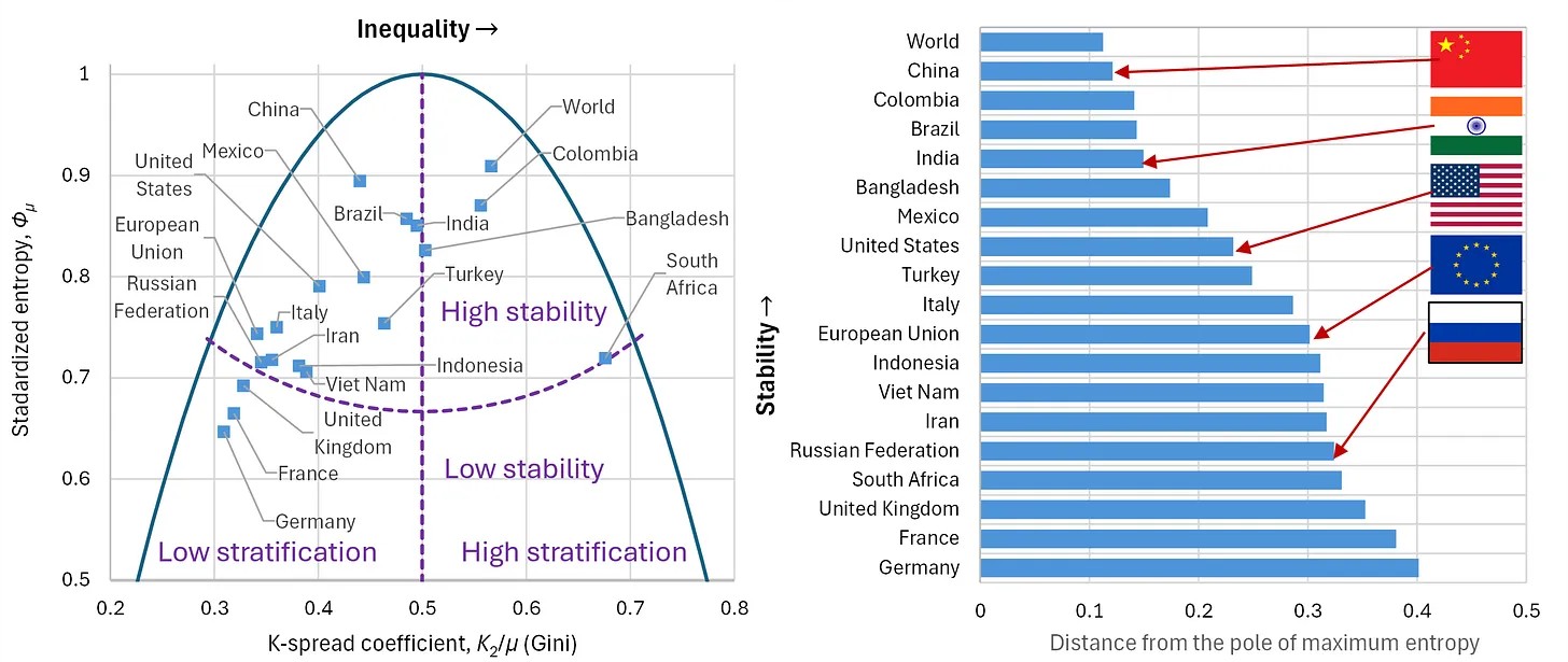
Full text: http://www.itia.ntua.gr/en/getfile/2583/1/documents/entropy-28-00035-v2.pdf (8215 KB)
Additional material:
- http://www.itia.ntua.gr/en/getfile/2583/2/documents/Fig13.jpg: Figure 13 (186 KB)
-
A. Tsouni, S. Sigourou, V. Pagana, M.-C. Tsoutsos, P. Dimitriadis, G.-F. Sargentis, T. Iliopoulou, R. Ioannidis, D. Dimitrakopoulou, E. Chardavellas, M.J. Alexopoulos, A. Koukouvinos, N. Mamassis, D. Koutsoyiannis, and C. Kontoes, Multiparameter flood risk assessment and management planning at high spatial resolution in the region of Attica, Greece, IEEE Journal of Selected Topics in Applied Earth Observations …, 18, 25966–25979, doi:10.1109/JSTARS.2025.3613569, 2025.
Floods are disastrous events as they induce fatalities, damages to the environment, properties, and infrastructure, at a global level. The Region of Attica, which hosts Athens (capital of Greece), has suffered various floods, including the severe flood in Mandra (2017) with 24 fatalities. In 2021, a Programming Agreement was signed between the Prefecture of Attica and the National Observatory of Athens to conduct the research study “Earthquake, fire and flood risk assessment in the Region of Attica” (Part A) in selected and most vulnerable areas. In the framework of this research and technical work, state-of-the-art methodologies were developed and implemented that support multiparameter flood risk assessment and management planning at high spatial resolution (building block level). This work integrates different data sources, including remote sensing, in-situ measurements, field visits, and simulations, and is characterized by considerable added value, as it supports the civil protection authorities as well as all the other relevant stakeholders in the decision-making, first response, and management of floods. Furthermore, this innovative approach is transferable, adaptable, and scalable, and it is now being implemented in the Garyllis river basin in Cyprus, in the framework of the “EXCELSIOR” H2020 Widespread Teaming project.
Full text: http://www.itia.ntua.gr/en/getfile/2568/1/documents/Multiparameter_Flood_Risk_Assessment.pdf (4874 KB)
-
G.-F. Sargentis, T. Iliopoulou, R. Ioannidis, M. Kougia, I. Benekos, P. Dimitriadis, A. Koukouvinos, D. Dimitrakopoulou, N. Mamassis, A. Tsouni, S. Sigourou, V. Pagana, C. Kontoes, and D. Koutsoyiannis, Technological Advances in Flood Risk Assessment and Related Operational Practices Since the 1970s: A Case Study in the Pikrodafni River of Attica, Water, 17(1) (112), doi:10.3390/w17010112, 2025.
As cities have expanded into floodplains, the need for their protection has become crucial, prompting the evolution of flood studies. Here, we describe the operational tools, methods and processes used in flood risk engineering studies in the 1970s, and we evaluate the technological progress up to the present day. To this aim, we reference relevant regulations and legislation and the recorded experiences of engineers who performed hydrological, surveying and hydraulic studies in the 1970s. These are compared with the operational framework of a contemporary flood risk assessment study conducted in the Pikrodafni basin in the Attica region. We conclude that, without the technologically advanced tools available today, achieving the level of detail and accuracy in flood mapping that is now possible would have been unfeasible, even with significant human resources. However, ongoing urban development and growth continue to encroach upon flood plains that have existed for centuries, contributing to increased flood risk.
Full text: http://www.itia.ntua.gr/en/getfile/2520/1/documents/water-17-00112.pdf (9652 KB)
-
G.-F. Sargentis, N. Mamassis, and D. Koutsoyiannis, The multifaceted importance of mediterranean pine-tree forests to social cohesion. Energy, resin, grazing, and wildfire management in North Euboea, Greece, Natural Resources Conservation and Research, 7, 15 pages, 9962, doi:10.24294/nrcr9962, 2024.
Forests are essential not only for their ecological roles but also as invaluable natural resources supporting biodiversity, climate regulation, and human livelihoods. In Mediterranean regions, pine-tree forests are particularly susceptible to intense wildfires, which pose significant challenges to containment and long-term forest health. This study focuses on the pine-tree forests of North Euboea, examining their embedded energy, natural regenerative capacity, and sustainable management approaches. Key aspects investigated include the forest’s contributions to biomass and resin productivity, the social and economic impacts of wildfire events, and the role of managed grazing as a proactive tool in fire prevention and forest stewardship. Our analysis highlights the potential benefits of grazing as a strategic measure to manage forest biomass levels, thereby reducing the fuel load and lowering the intensity of possible future fires. Grazing is also shown to support broader access across the forest landscape, allowing firefighting forces to respond more effectively in case of a fire outbreak. By utilizing grazing to maintain forest ecosystems beyond just the periphery, this approach can enhance both ecological resilience and community cohesion in regions vulnerable to forest fires. The study underscores the need for integrated management practices that balance forest use with conservation, leveraging grazing as a means to sustain the health and accessibility of Mediterranean pine-tree forests.
Full text: http://www.itia.ntua.gr/en/getfile/2515/1/documents/Sci_The_multifaceted_importance_of_mediterranean_pine-tree_forests_to_soci...hesion.pdf (3248 KB)
-
G.-F. Sargentis, R. Ioannidis, P. Dimitriadis, N. Malamos, O. Lyra, O. Kitsou, M. Kougia, N. Mamassis, and D. Koutsoyiannis, Energy Self-Sufficiency in Rural Areas; Case Study: North Euboea, Greece, Advances in Environmental and Engineering Research, 5 (4), 20 pages, doi:10.21926/aeer.2404025, 2024.
The modern globalized civilization is sustained by interactions, trade, the transportation of goods, and energy. Energy self-sufficiency is crucial in rural and disaster-prone areas like North Euboea because dependence on external energy supplies can leave regions vulnerable to supply chain disruptions, price volatility, and geopolitical risks. In such isolated regions, energy independence ensures resilience in natural disasters and economic instability. The alternative to self-sufficiency often involves reliance on centralized energy systems, fossil fuels, or external imports, which may not always be reliable or sustainable. Therefore, in this study, we explore the possibility of an area having energy self-sufficiency. As a case study, we chose North Euboea in Greece, explicitly focusing on the Municipality of Mantoudi-Limni-Agia Anna. The analysis combines local land use patterns, energy needs for inhabitants, agriculture and water requirements. It is followed by exploring various renewable energy sources, including hydropower, biomass, solar, and wind. We considered the stochastic nature of renewable energy production and the challenges associated with energy storage. The findings suggest that while wind turbines and solar panels could be installed in the area and contribute significantly to energy needs, achieving complete self-sufficiency requires careful planning, particularly regarding energy storage and the social acceptance of these installations. The results highlight the need for a holistic approach that integrates environmental, landscape, societal, and technical considerations in designing and implementing renewable energy systems. Additionally, it is highlighted that the available renewable energy from forest biomass (before the 2021 megafire event) could reliably and adequately meet the area's energy needs without requiring investments in photovoltaic parks and wind turbines and without competing with the use of agricultural land.
Full text: http://www.itia.ntua.gr/en/getfile/2514/1/documents/aeer.2404025.pdf (2020 KB)
-
G.-F. Sargentis, R. Ioannidis, N. Mamassis, V. Zoukos, and D. Koutsoyiannis, A review of the energy policy in Greece in the last 50 years and its implications for prosperity, Clean Energy and Sustainability, 2 (4), 10021, doi:10.70322/ces.2024.10021, 2024.
This paper elucidates the development of electricity production and distribution in Greece from the 1950s to date, in correlation with national and European energy policy. During this period, Greece experienced a multifaceted energy transition, including both the transition of ownership of energy generation companies from public to private and a transition from an energy mix in which coal (lignite) served as a major and inexpensive resource to a mix in which wind power, solar power and natural gas gained a primary role, but with high costs for energy generation. The correlation between electrical energy consumption and economic growth is explored in this context, revealing an increase in consumption before the 2009 recession and a decline thereafter. The study investigates the correlation between escalating electricity prices and legislative dependencies that mandated the purchase of wind- and solar-generated electricity at exorbitant rates, the closure of cost-effective lignite units, and the reliance on natural gas—a commodity susceptible to geopolitical shifts. It also shows that, given the structure of the Greek energy mix, the increase in the share of wind and solar energy in the mix is directly related to the increase in the price of electricity. Highlighting the importance of energy costs for prosperity, this paper underscores, through the detailed review of the Greek energy “landscape”, that the major determinants of electricity prices are both the accessibility to natural resources but also their proper and judicious management.
Full text: http://www.itia.ntua.gr/en/getfile/2509/1/documents/2024EnergyPolicyGreece2.pdf (1228 KB)
Additional material:
- http://www.itia.ntua.gr/en/getfile/2509/2/documents/EnergyPolicyInGreecePrehistory.pdf: Prehistory of rejections (135 KB)
-
G.-F. Sargentis, K. Moraiti, I. Benekos, R. Ioannidis, and N. Mamassis, Fast-Track Documentation of the Alterations on the Landscape, before and after a Natural Hazard—Case Study: North Euboea Greece before and after Storms Daniel and Elias, Rural and Regional Development, 2, 10016, doi:10.70322/rrd.2024.10016, 2024.
Full text: http://www.itia.ntua.gr/en/getfile/2496/1/documents/d3865795af92e6d596c82e5855e927bb_1.pdf (1298 KB)
-
K. Moraiti, S. Sigourou, P. Dimitriadis, R. Ioannidis, I. Benekos, T. Iliopoulou, O. Kitsou, N. Mamassis, D. Koutsoyiannis, and G.-F. Sargentis, Documenting the changing floodplain of Nileas Basin in North Euboea (Greece) before and after Storms Daniel and Elias, Rural and Regional Development, 2 (3), 10013, doi:10.35534/rrd.2024.10013, 2024.
The area of north Euboea is characterized by its intense relief, dense hydrographic network, and rich flora and fauna. In the mid-2010s, the region was struck by a plane tree disease that withered the large population of plane trees in the area, while in 2021, a large wildfire completely burned the forest. These unfortunate events depleted the landscape’s natural ability to manage and mitigate flood phenomena. Observing the landscape’s vulnerability to floods, in April 2023, we conduct on-site field inspections in the rivers of the area. In September 2023, a major flood hit the area, causing in dramatic changes to the landscape. Therefore, in November 2023, we conducted follow-up on-site field inspections in the area, in order to trace the differences, present the damages the phenomenon left behind. These inspections allowed to document the landscape changes from the combination of all previous events and identify any associated pathologies. Site visits and comparisons before and after the Daniel/Elias storm revealed dramatic changes in the riverbed width at lower altitudes, significant sediment accumulation in the Voudouros River delta, alterations in the natural landscape along the river and its floodplain, destruction of the arable land, and road collapses in several locations.
Full text: http://www.itia.ntua.gr/en/getfile/2465/1/documents/df859480db58f57a93db8ae1fd1e29cf.pdf (1896 KB)
Additional material:
- http://www.itia.ntua.gr/en/getfile/2465/2/documents/7ef95898bc097b7e57a3160ccb2d70c1.pdf: Supplementary material (9317 KB)
-
G.-F. Sargentis, N. Mamassis, O. Kitsou, and D. Koutsoyiannis, The role of technology in the water–energy–food nexus. A case study: Kerinthos, North Euboea, Greece, Frontiers in Water, 6, 1343344, doi:10.3389/frwa.2024.1343344, 2024.
The water–energy–food (WEF) nexus is a basic element of prosperity, yet it is not equally distributed on the land. Human progress has optimized the function of the WEF nexus to bridge the inequality gap. In order to understand this progress, this study compares the preindustrial and modern agricultural practices in an area in Greece. Interviews were conducted with an elderly man who lived in the 1950s, and the process was quantified in units of WEF. The same procedure was also carried out with modern farmers for modern agricultural practices. In comparing the past and present agricultural processes, it is observed that today, a farmer can feed approximately 100 times more people. This feat has been achieved as modern practices push the land with energy sources in multiple ways (fuels and fertilizers). However, energy indices such as energy ratio, net energy gain, specific energy, and energy productivity do not seem to be improved. Furthermore, farmers prefer to pump underground water for irrigation, instead of utilizing the nearby river, as was done in the past when the river provided both energy to the watermill and an abundance of water for irrigation. In addition, as the price of wheat is dependent on the stock market, even in 2023, there are risks to food security, the cultivation of wheat was not economically efficient for farmers in this area in 2023.
Full text: http://www.itia.ntua.gr/en/getfile/2442/1/documents/frwa-06-1343344.pdf (4149 KB)
-
N. Wang, F. Sun, D. Koutsoyiannis, T. Iliopoulou, T. Wang, H. Wang, W. Liu, G.-F. Sargentis, and P. Dimitriadis, How can changes in the human-flood distance mitigate flood fatalities and displacements?, Geophysical Research Letters, 50 (20), e2023GL105064, doi:10.1029/2023GL105064, 2023.
Comprehending the correlation between alterations in human-flood distance and flood fatalities (as well as displacements) is pivotal for formulating effective human adaptive strategies in response to floods. However, this relationship remains inadequately explored in existing global analyses. To address this gap, we examine 910 flood events occurring from 2000 to 2018, resulting in significant numbers of fatalities and displacements. We find that in 53% of countries, humans tend to distance from floods, particularly in the Middle East. Such distancing greatly mitigates flood fatalities and displacements. Simultaneously, in areas with increased flood protection level (FPL), humans are less likely to move away from floods. Furthermore, FPL and human-flood distance have decreased in regions affected by ice jam- and hurricane-induced floods from 2000 to 2018. Notably, regions with human-flood distance slightly below the average for a given flood type experience more severe flood fatalities.
Full text: http://www.itia.ntua.gr/en/getfile/2348/1/documents/2023GRL-Wang-ChangesInHumanFloodDistance.pdf (2069 KB)
-
G.-F. Sargentis, and D. Koutsoyiannis, The function of money in water–energy–food and land nexus, Land, 12 (3), 669, doi:10.3390/land12030669, 2023.
The water–energy–food (WEF) and land nexus is a basic element of prosperity. However, the elements of WEF are not equally distributed, and the dynamics of trading drives the distribution of goods. Money controls the trading, but money is just a convention and not a stable measure. Therefore, we have used the data of gross domestic product (GDP) and the price of electricity of each country in order to convert money to stable energy units. To evaluate the role of money in the WEF nexus, we also convert all the elements of the nexus, in energy units. In addition, we observe that land is the base of WEF and is positively correlated with all of its elements. However, we find that even the richest countries are facing critical deficits in WEF. Adding the money (GDP in energy units) to the WEF nexus, the balance becomes positive and we conclude that trading is necessary for both survival and prosperity. This may be obvious, but at present, global geopolitical conflicts which use economic sanctions as a tool transform the global balance of the WEF nexus, putting the global prosperity in jeopardy.
Full text: http://www.itia.ntua.gr/en/getfile/2274/1/documents/land-12-00669-v2.pdf (3780 KB)
-
G.-F. Sargentis, R. Ioannidis, I. Bairaktaris, E. Frangedaki, P. Dimitriadis, T. Iliopoulou, D. Koutsoyiannis, and N. D. Lagaros, Wildfires vs. sustainable forest partitioning, Conservation, 2 (1), 195–218, doi:10.3390/conservation2010013, 2022.
There is a widespread perception that every year wildfires are intensifying on a global scale, something that is often used as an indicator of the adverse impacts of global warming. However, from the analysis of wildfires that have occurred in the US, Canada, and Mediterranean countries, a trend that justifies this perception could not be identified. Arguably, instead of blaming climate change, research on the mitigation of wildfires should be re-directed to forest management policy and practices. Forests are admirable and complex natural ecosystems, and fires, albeit devastating, can be attributed to both human activity and to natural processes that contribute to their rebirth, with the latter constituting an intrinsic and perpetual process of the forest ecosystem. Other than their important ecological value, forests are, in the 21st century, also a capital resource, for many people’s livelihoods depend on them. In this study, we proposed a method for taking mitigation measures against wildfires based on the partitioning of forests, considering both the protection of the ecosystem and the inhabitants and aiming to utilize their co-dependent nature for the general protection and preservation of forests. As a case study, we analyzed the current devastating fire in Euboea (occurred in August 2021), initially in terms of the spatio-temporal progression of the actual wildfire that lasted several days and then by examining how an implementation of the proposed method in the study area could contribute to both the recovery of the ecosystem and the enhancement of the quality of life of the inhabitants as well as their long-term protection.
Full text: http://www.itia.ntua.gr/en/getfile/2281/1/documents/conservation-02-00013-v2.pdf (13186 KB)
-
D. Markantonis, G.-F. Sargentis, P. Dimitriadis, T. Iliopoulou, A. Siganou, K. Moraiti, M. Nikolinakou, I. Meletopoulos, N. Mamassis, and D. Koutsoyiannis, Stochastic Evaluation of the Investment Risk by the Scale of Water Infrastructures-Case Study: The Municipality of West Mani (Greece), World, 4 (1), 1–20, doi:10.3390/world4010001, 2022.
Social structure is based on the availability of the Water-Energy-Food Nexus. To cover these needs of society, several solutions of different scales of infrastructures coexist. The construction of infrastructure is capital-intensive; therefore, investment risk is always a consideration. In this paper, we try to evaluate the investment risk by interest rates (IR). We show that IR is a key indicator, which includes multiple parameters of prosperity expressing the political and economic status quo of the society. The selection of a particular scale influences the required capital and is thus one of the most critical decisions. Water supply infrastructure is one of the foundations of society, and the selection of the optimal scale of such infrastructure is often a great challenge in civil engineering. As a case study, we analyse three different scales of water supply infrastructures for the area of West Mani (Greece), i.e., dam, water ponds, and seawater desalination. We evaluate each case by the capital intensity by performing stochastic simulations of interest rates and identify the optimal solution as the one with the smallest median unit cost, in this case, the water ponds. In order to assess the impact of the development level of a country on the resulting unit cost stochastic properties we apply the optimal solution to various countries with different development levels and IR. We show that IR in the least developed countries, being generally higher and more variable, increases the unit cost, including its variability, which ultimately indicates higher investment risk.
Full text: http://www.itia.ntua.gr/en/getfile/2265/1/documents/world-04-00001-v2.pdf (4536 KB)
-
G.-F. Sargentis, D. Koutsoyiannis, A. N. Angelakis, J. Christy, and A.A. Tsonis, Environmental determinism vs. social dynamics: Prehistorical and historical examples, World, 3 (2), 357–388, doi:10.3390/world3020020, 2022.
Environmental determinism is often used to explain past social collapses and to predict the future of modern human societies. We assess the availability of natural resources and the resulting carrying capacity (a basic concept of environmental determinism) through a toy model based on Hurst–Kolmogorov dynamics. We also highlight the role of social cohesion, and we evaluate it from an entropic viewpoint. Furthermore, we make the case that, when it comes to the demise of civilizations, while environmental influences may be in the mix, social dynamics is the main driver behind their decline and eventual collapse. We examine several prehistorical and historical cases of civilization collapse, the most characteristic being that of the Minoan civilization, whose disappearance c. 1100 BC has fostered several causative hypotheses. In general, we note that these hypotheses are based on catastrophic environmental causes, which nevertheless occurred a few hundred years before the collapse of Minoans. Specifically, around 1500 BC, Minoans managed to overpass many environmental adversities. As we have not found justified reasons based on the environmental determinism for when the collapse occurred (around 1100 BC), we hypothesize a possible transformation of the Minoans’ social structure as the cause of the collapse.
Full text: http://www.itia.ntua.gr/en/getfile/2247/1/documents/world-03-00020.pdf (10291 KB)
-
T. Iliopoulou, P. Dimitriadis, A. Siganou, D. Markantonis, K. Moraiti, M. Nikolinakou, I. Meletopoulos, N. Mamassis, D. Koutsoyiannis, and G.-F. Sargentis, Modern use of traditional rainwater harvesting practices: An assessment of cisterns’ water supply potential in West Mani, Greece, Heritage, 5 (4), 2944–2954, doi:10.3390/heritage5040152, 2022.
Water has always been a driver of human civilization. The first human civilizations thrived in places with an abundance of water, typically nearby large rivers as the Tigris–Euphrates, Yang Che and Nile. The invention and construction of hydraulic infrastructure came only later, in prehistoric times, triggered by the expansion of humanity in water-scarce areas. The ancient Greeks invented impressive hydraulic works and small-scale structures, some of which, such as cisterns, were still fully operational until the 20th century. We present a model that explains the use of cisterns in the water-scarce area of West Mani, which allows us to assess the potential of this traditional rainfall harvesting practice to support the modern water supply needs. To assess the system’s reliability, we employ a long-term simulation of a typical cistern system, using synthetic rainfall series from a stochastic model, and assuming variable water demand on a monthly scale. We show that a proper restoration of the cisterns could be sustainable as a complementary water supply source, decreasing the area’s drinking water cost and increasing the locals’ resilience against water shortages. In addition, we highlight the links between the area’s hydroclimate and its history and discuss the cultural merits of reviving and preserving this ancient, long practice.
Full text: http://www.itia.ntua.gr/en/getfile/2243/1/documents/heritage-05-00152-v3.pdf (4196 KB)
-
G.-F. Sargentis, N. D. Lagaros, G.L. Cascella, and D. Koutsoyiannis, Threats in Water–Energy–Food–Land Nexus by the 2022 Military and Economic Conflict, Land, doi:10.3390/land11091569, 2022.
The formation of societies is based on the dynamics of spatial clustering, which optimizes economies of scale in the management of the water–energy–food (WEF) nexus. Energy and food are determinant measures of prosperity. Using the WEF nexus as an indicator, we evaluate the social impacts of the current (2022) conflict and in particular the economic sanctions on Russia. As Russia and Ukraine are major global suppliers of energy sources, food, and fertilizers, new threats arise by their limitations and the rally of prices. By analyzing related data, we show the dramatic effects on society, and we note that cities, which depend on a wider area for energy and food supplies, are extremely vulnerable. This problem was substantially worsened due to the large-scale urbanization in recent decades, which increased the distance from food sources. We conjecture that the Western elites’ decision to sanction Russia dramatically transformed the global WEF equilibrium, which could probably lead to the collapse of social cohesion.
Full text: http://www.itia.ntua.gr/en/getfile/2239/1/documents/land-11-01569-v2.pdf (4700 KB)
-
R. Ioannidis, G.-F. Sargentis, and D. Koutsoyiannis, Landscape design in infrastructure projects - is it an extravagance? A cost-benefit investigation of practices in dams, Landscape Research, doi:10.1080/01426397.2022.2039109, 2022.
Landscape design of major civil infrastructure works has often been undermined as a policy requirement or been neglected in practice. We investigate whether this is justified by technical challenges, high costs or proven lack of utility of landscape design of infrastructure, focussing on dam-design practice. Initially, we investigate global practice and identify 56 cases of dams in which landscape or architectural treatment has been applied. We then create a typology of utilised design techniques and investigate their contribution to improving landscape quality perception through literature review and through the analysis of photograph upload densities in geotagged photography databases. Finally, we investigate costs of landscape works, analysing three dam projects in detail. The results demonstrate that landscape design of civil infrastructure (a) improves landscape quality perception of infrastructures’ landscapes and (b) that its implementation can be both economically and technically feasible, especially if existing knowledge from best practices is utilised.
Additional material:
- http://www.itia.ntua.gr/en/getfile/2181/2/documents/IoannidisEtal2022.pdf: Preprint (1194 KB)
- http://www.itia.ntua.gr/en/getfile/2181/3/documents/clar_a_2039109_sm1612.zip: Supplementary Information (277 KB)
-
G.-F. Sargentis, E. Frangedaki, M. Chiotinis, D. Koutsoyiannis, S. Camarinopoulos, A. Camarinopoulos, and N. D. Lagaros, 3D scanning/printing: a technological stride in sculpture, Technologies, doi:10.3390/technologies10010009, 2022.
The creation of innovative tools, objects and artifacts that introduce abstract ideas in the real world is a necessary step for the evolution process and characterize the creative capacity of civilization. Sculpture is based on the available technology for its creation process and is strongly related to the level of technological sophistication of each era. This paper analyzes the evolution of basic sculpture techniques (carving, lost-wax casting and 3D scanning/printing), and their importance as a culture footprint. It also presents and evaluates the added creative capacities of each technological step and the different methods of 3D scanning/printing concerning sculpture. It is also an attempt to define the term “material poetics”, which is connected to sculpture artifacts. We conclude that 3D scanning/printing is an important sign of civilization, although artifacts lose a part of material poetics with additive manufacturing. Subsequently, there are various causes of the destruction of sculptures, leaving a hole in the history of art. Finally, this paper showcases the importance of 3D scanning/printing in salvaging cultural heritage, as it has radically altered the way we “backup” objects.
Full text: http://www.itia.ntua.gr/en/getfile/2175/1/documents/technologies-10-00009-v3.pdf (13152 KB)
-
D. Koutsoyiannis, and G.-F. Sargentis, Entropy and wealth, Entropy, 23 (10), 1356, doi:10.3390/e23101356, 2021.
While entropy was introduced in the second half of the 19th century in the international vocabulary as a scientific term, in the 20th century it became common in colloquial use. Popular imagination has loaded “entropy” with almost every negative quality in the universe, in life and in society, with a dominant meaning of disorder and disorganization. Exploring the history of the term and many different approaches to it, we show that entropy has a universal stochastic definition, which is not disorder. Hence, we contend that entropy should be used as a mathematical (stochastic) concept as rigorously as possible, free of metaphoric meanings. The accompanying principle of maximum entropy, which lies behind the Second Law, gives explanatory and inferential power to the concept, and promotes entropy as the mother of creativity and evolution. As the social sciences are often contaminated by subjectivity and ideological influences, we try to explore whether maximum entropy, applied to the distribution of a wealth-related variable, namely annual income, can give an objective description. Using publicly available income data, we show that income distribution is consistent with the principle of maximum entropy. The increase in entropy is associated to increases in society’s wealth, yet a standardized form of entropy can be used to quantify inequality. Historically, technology has played a major role in the development of and increase in the entropy of income. Such findings are contrary to the theory of ecological economics and other theories that use the term entropy in a Malthusian perspective.
Remarks:
The extended summary is also posted in https://clintel.org/entropy-and-wealth/
Full text: http://www.itia.ntua.gr/en/getfile/2150/1/documents/entropy-23-01356-v3.pdf (7617 KB)
Additional material:
- http://www.itia.ntua.gr/en/getfile/2150/3/documents/EntropyAndWealthPlain.pdf: Extended summary (in plain language) [doi: 10.13140/RG.2.2.21605.52960] (500 KB)
- http://www.itia.ntua.gr/en/getfile/2150/6/documents/Entropy_and_Wealth_20211109.pdf: Presentation (7018 KB)
-
P. Dimitriadis, T. Iliopoulou, G.-F. Sargentis, and D. Koutsoyiannis, Spatial Hurst–Kolmogorov Clustering, Encyclopedia, 1 (4), 1010–1025, doi:10.3390/encyclopedia1040077, 2021.
The stochastic analysis in the scale domain (instead of the traditional lag or frequency domains) is introduced as a robust means to identify, model and simulate the Hurst–Kolmogorov (HK) dynamics, ranging from small (fractal) to large scales exhibiting the clustering behavior (else known as the Hurst phenomenon or long-range dependence). The HK clustering is an attribute of a multidimensional (1D, 2D, etc.) spatio-temporal stationary stochastic process with an arbitrary marginal distribution function, and a fractal behavior on small spatio-temporal scales of the dependence structure and a power-type on large scales, yielding a high probability of low- or high-magnitude events to group together in space and time. This behavior is preferably analyzed through the second-order statistics, and in the scale domain, by the stochastic metric of the climacogram, i.e., the variance of the averaged spatio-temporal process vs. spatio-temporal scale.
-
G.-F. Sargentis, P. Siamparina, G.-K. Sakki, A. Efstratiadis, M. Chiotinis, and D. Koutsoyiannis, Agricultural land or photovoltaic parks? The water–energy–food nexus and land development perspectives in the Thessaly plain, Greece, Sustainability, 13 (16), 8935, doi:10.3390/su13168935, 2021.
Water, energy, land, and food are vital elements with multiple interactions. In this context, the concept of a water–energy–food (WEF) nexus was manifested as a natural resource management approach, aiming at promoting sustainable development at the international, national, or local level and eliminating the negative effects that result from the use of each of the four resources against the other three. At the same time, the transition to green energy through the application of renewable energy technologies is changing and perplexing the relationships between the constituent elements of the nexus, introducing new conflicts, particularly related to land use for energy production vs. food. Specifically, one of the most widespread “green” technologies is photovoltaic (PV) solar energy, now being the third foremost renewable energy source in terms of global installed capacity. However, the growing development of PV systems results in ever expanding occupation of agricultural lands, which are most advantageous for siting PV parks. Using as study area the Thessaly Plain, the largest agricultural area in Greece, we investigate the relationship between photovoltaic power plant development and food production in an attempt to reveal both their conflicts and their synergies.
Full text: http://www.itia.ntua.gr/en/getfile/2136/1/documents/sustainability-13-08935.pdf (2709 KB)
See also: https://www.mdpi.com/2071-1050/13/16/8935
Other works that reference this work (this list might be obsolete):
1. Abouaiana, A., and A. Battisti, Multifunction land use to promote energy communities in Mediterranean region: Cases of Egypt and Italy, Land, 11(5), 673, doi:10.3390/land11050673, 2022. 2. Reasoner, M., and A. Ghosh, Agrivoltaic engineering and layout optimization approaches in the transition to renewable energy technologies: a review, Challenges, 13(2), 43, doi:10.3390/challe13020043, 2022. 3. Bhambare, P. S., and S. C. Vishweshwara, Design aspects of a fixed focus type Scheffler concentrator and its receiver for its utilization in thermal processing units, Energy Nexus, 7, 100103, doi:10.1016/j.nexus.2022.100103, 2022. 4. Padilla, J., C. Toledo, and J. Abad, Enovoltaics: Symbiotic integration of photovoltaics in vineyards, Frontiers in Energy Research, 10, 1007383, doi:10.3389/fenrg.2022.1007383, 2022. 5. Garcia, J. A., and A. Alamanos, Integrated modelling approaches for sustainable agri-economic growth and environmental improvement: Examples from Greece, Canada and Ireland, Land, 11(9), 1548, doi:10.3390/land11091548, 2022. 6. Dias, I. Y. P., L. L. B. Lazaro, and V. G. Barros, Water–energy–food security nexus—estimating future water demand scenarios based on nexus thinking: The watershed as a territory, Sustainability, 15(9), 7050, doi:10.3390/su15097050, 2023. 7. Goldberg, G. A., Solar energy development on farmland: Three prevalent perspectives of conflict, synergy and compromise in the United States, Energy Research & Social Science, 101, 103145, doi:10.1016/j.erss.2023.103145, 2023. 8. Lucca, E., J. El Jeitany, G. Castelli, T. Pacetti, E. Bresci, F. Nardi, and E. Caporali, A review of water-energy-food-ecosystems nexus research in the Mediterranean: Evolution, gaps and applications, Environmental Research Letters, 18, 083001, doi:10.1088/1748-9326/ace375, 2023. 9. Zavahir, S., T. Elmakki, M. Gulied, H. K. Shon, H. Park, K. K. Kakosimos, and D. S. Han, Integrated photoelectrochemical (PEC)-forward osmosis (FO) system for hydrogen production and fertigation application, Journal of Environmental Chemical Engineering, 11(5), 110525, doi:10.1016/j.jece.2023.110525, 2023. 10. Karasmanaki, E., S. Galatsidas, K. Ioannou, and G. Tsantopoulos, Investigating willingness to invest in renewable energy to achieve energy targets and lower carbon emissions, Atmosphere, 14(10), 1471, doi:10.3390/atmos14101471, 2023. 11. Zhou, Z., H. Liao, H. Li, X. Gu, and M. M. Ageli, The trilemma of food production, clean energy, and water: COP27 perspective of global economy, Land Degradation and Development, 35(4), 1425-1436, doi:10.1002/ldr.4996, 2024. 12. Kock, S., R. Piastrellini, and A. P. Arena, Assessment of the water-energy-food nexus in the life cycle of energy products, Heliyon, doi:10.1016/j.heliyon.2024.e31961, 2024. 13. Sargentis, G. F., and M. Kougkia, Vulnerabilities of water-energy and food nexus in cities of digital era, Insight - Civil Engineering, 7(1), 608, doi:10.18282/ice.v7i1.608, 2024. 14. Chang, H., B. Zhang, J. Han, Y. Zhao, Y. Cao, J. Yao, and L. Shi, Evaluation of the coupling coordination and sustainable development of water–energy–land–food system on a 40-year scale: A case study of Hebei, China, Land, 13(7), 1089, doi:10.3390/land13071089, 2024. 15. Rosley, M. S. F., N. Z. Harun, J. N. Yusof, and S. R. Abdul Rahman, Empowering public participation in assessing the indicators of aesthetic value for historical landscape: a case study on Melaka, Malaysia, Cogent Arts & Humanities, 11(1), doi:10.1080/23311983.2024.2380114, 2024. 16. Wang, J., X. Cui, M. Zhao, T. Zheng, C. Tu, and Y. Zhang, Research on the synergy of the water–energy–food composite system in the Beijing–Tianjin–Hebei region, Water Policy, 26(9), 875-894, doi:10.2166/wp.2024.065, 2024. 17. Uzoechina, B. I., J. O. Ezekwike, G. A. Ekwoh, E. A. Eze, P. C. Imoagwu, and J. N. Edeh, Impact of energy consumption on life expectancy in lower-middle-income West African countries, Global Health Economics and Sustainability, 3518, doi:10.36922/ghes.3518, 2024. 18. Dias, I. Y. P., L. L. B. Lazaro, M. P. B. de Castro, R. N. Dagios, and V. G. Barros, Watersheds governance optimizing water-energy-food nexus approach across water users and watershed scales, Water Resources Management, doi:10.1007/s11269-024-03984-9, 2024. 19. Neto, A. B., A. G. Rocha, and B. G. de Oliveira, Reconciling photovoltaic energy production and agribusiness: Challenges for sustainable energy growth and land use for agricultural production, Estudios Rurales, 14(30), doi:10.48160/22504001er30.540, 2024. 20. #García-Vila, M., m. G. Rivera Ferre, T. Chfadi, A. El Kenawy, C. Branquinho, J. Lorenzo-Lacruz, E. Menichetti, S. Mohammed, and A. Sanz-Cobena, Drivers of change and their impacts on the WEFE nexus in the Mediterranean region. In: Interlinking Climate Change with the Water-Energy-Food-Ecosystems (WEFE) Nexus in the Mediterranean Basin, Drobinski, P., Rivera Ferre, M.G., Abdel Monem, M., Driouech, F., Cramer, W., Guiot, J., Gattacceca, J.C., Marini, K. (eds.), MedECC Reports, MedECC Secretariat, Marseille, France, 57-139, doi:10.5281/zenodo.13378622, 2024. 21. Lucca, E., D. Kofinas, T. Avellán, J. Kleemann, C. E. Mooren, M. Blicharska, C. Teutschbein, A. Sperotto, J. Sušnik, S. Milliken, M. Fader, D. Đorđević, T. Dašić, V. Vasilić, B. Taiwo, A. Baubekova, R. Pineda-Martos, A. Spyropoulou, G. F. M. Baganz, J. el Jeitany, H. V. Oral, M. Merheb, G. Castelli, A. Pagano, B. Sambo, M. Suškevičs, M. Arnold, T. Rađenović, A. Psomas, S. Masia, I. La Jeunesse, H. Amorocho-Daza, S. S. Das, E. Bresci, S. Munaretto, F. Brouwer, and C. Laspidou, Integrating “nature” in the water-energy-food Nexus: Current perspectives and future directions, Science of The Total Environment, 966, 178600, doi:10.1016/j.scitotenv.2025.178600, 2025. 22. Mentzafou A., E. Dimitriou, I. Karaouzas, and S. Zogaris, Impact assessment of floating photovoltaic systems on the water quality of Kremasta Lake, Greece, Hydrology, 12(4), 92, doi:10.3390/hydrology12040092, 2025. 23. Migkos, S. P., P. Karountzos, N. T. Giannakopoulos, D. P. Sakas, A. Katarachia, and P. Μ. Farmaki, Energy and environmental impacts of greece’s agricultural sector: A diachronic study with regional insights from Western Macedonia, Journal of Environmental & Earth Sciences, 7(5), 332–59, doi:10.30564/jees.v7i5.8363, 2025. 24. Lagarias, A., Climate change as spatial change: repercussions of the disastrous Daniel flood in Thessaly Region on its territorial future, GeoJournal, 90, 154, doi:10.1007/s10708-025-11407-4, 2025. 25. #Yfanti, S., M. Nikologiannis, G. Viskadouros, M. Markaki, S. Iltsidis, and E. Karapidakis, Greek Energy Communities: Maintaining a project’s sustainability within the context of energy exchange, E3S Web of Conferences, 638, 02012, doi:10.1051/e3sconf/202563802012, 2025. 26. Faraslis, I., V. Margaritopoulou, C. Christakis, and E. Providas, Evaluating landscape fragmentation and consequent environmental impact of solar parks installation in Natura 2000 protected areas: The case of the Thessaly region, Central Greece, Sustainability, 17(15), 7158, doi:10.3390/su17157158, 2025. 27. Zhang, C., J. Shi, X. Zhao, and E. Pei, Driving factors of spatial–temporal differences in agricultural energy consumption evolution in the Yellow River Basin: A perspective of water–energy–food–land–population nexus, Water, 17(20), 2971, doi:10.3390/w17202971, 2025. 28. Drobinski, P., M. G., Rivera Ferre, M. A. Monem, A. A. Hatab, M. Behnassi, T. Chfadi, W. Cramer, M. Debolini, F. Driouech, A. El-Kenawy, M. García-Vila, J. Guiot, E. Lamonaca, F. López-i-Gelats, Ž. Malek, M. P. Papadopoulou, and F. G. Santeramo, Nexus approach to enhance water-energy-food security and ecosystems resilience under climate change in the Mediterranean, npj Climate Action, 4, 115, doi:10.1038/s44168-025-00308-4, 2025. 29. Rizkiawan, M. A., T. Aisyah, and H. Ramza, Pendekatan Profesionalisme dalam Proyek Keinsinyuran: Studi Kasus Smart Greenhouse Bertenaga Surya, Jurnal Profesi Insinyur Universitas Lampung, 6(2), 355-362, doi:10.23960/jpi.v6n2.259, 2025. 30. Mehta, K., and F. Betz, Agri-photovoltaics in India: Geospatial suitability for sustainable water–energy–food nexus solutions, Energy for Sustainable Development, 91, 101915, doi:10.1016/j.esd.2025.101915, 2026. 31. Aydin, T. K., Optimum location selection for photovoltaic power plants based on Best-Worst Method: Example of Karatay district Konya, Türkiye, Environmental Progress & Sustainable Energy, doi:10.1002/ep.70301, 2026. 32. Koutsou, S., G. Kountios, and A. Ragkos, Energy transition and disruption of rural communities in Northern Greece: The role of territorial intelligence, Sustainability, 18(4), 1992, doi:10.3390/su18041992, 2026. 33. Petrovic, D., F. Schrade, S. Bosch, and H. Kunstmann, Too little space for renewables? Modeling carbon-neutral energy futures in southern Germany, Applied Geography, 190, 103977, doi:10.1016/j.apgeog.2026.103977, 2026. 34. Avista, Z., M. A. Rizkiawan, and Y. Witanto, Smart hydroponic greenhouse with solar energy for urban agriculture, Telecommunication Computing Electronics and Control, 24(2), 727-736, doi:10.12928/TELKOMNIKA.v24i2.27630, 2026. 35. Petrovic, D., F. Schrade, S. Bosch, and H. Kunstmann, Too little space for renewables? Modeling carbon-neutral energy futures in southern Germany, Applied Geography, 190, 103977, doi:10.1016/j.apgeog.2026.103977, 2026.
-
G.-F. Sargentis, T. Iliopoulou, P. Dimitriadis, N. Mamassis, and D. Koutsoyiannis, Stratification: An entropic view of society's structure, World, 2, 153–174, doi:10.3390/world2020011, 2021.
In human societies, we observe a wide range of types of stratification, i.e., in terms of financial class, political power, level of education, sanctity, and military force. In financial, political, and social sciences, stratification is one of the most important issues and tools as the Lorenz Curve and the Gini Coefficient have been developed to describe some of its aspects. Stratification is greatly dependent on the access of people to wealth. By “wealth”, we mean the quantified prosperity which increases the life expectancy of people. Prosperity is also connected to the water‐food‐energy nexus which is necessary for human survival. Analyzing proxies of the water‐food‐energy nexus, we suggest that the best proxy for prosperity is energy, which is closely related to Gross Domestic Product (GDP) per capita and life expectancy. In order to describe the dynamics of social stratification, we formulate an entropic view of wealth in human societies. An entropic approach to income distribution, approximated as available energy in prehistoric societies, till present‐day economies, shows that stratification can be viewed as a stochastic process subject to the principle of maximum entropy and occurring when limits to the wealth of society are set, either by the political and economic system and/or by the limits of available technology.
Full text: http://www.itia.ntua.gr/en/getfile/2107/1/documents/world-02-00011-v3.pdf (10384 KB)
Works that cite this document: View on Google Scholar or ResearchGate
-
G.-F. Sargentis, P. Dimitriadis, T. Iliopoulou, and D. Koutsoyiannis, A stochastic view of varying styles in art paintings, Heritage, 4, 21, doi:10.3390/heritage4010021, 2021.
A physical process is characterized as complex when it is difficult to analyze and explain in a simple way, and even more difficult to predict. The complexity within an art painting is expected to be high, possibly comparable to that of nature. Herein, we apply a 2D stochastic methodology to images of both portrait photography and artistic portraits, the latter belonging to different genres of art, with the aim to better understand their variability in quantitative terms. To quantify the dependence structure and variability, we estimate the Hurst parameter, which is a common dependence metric for hydrometeorological processes. We also seek connections between the identified stochastic patterns and the desideratum that each art movement aimed to express. Results show remarkable stochastic similarities between portrait paintings, linked to philosophical, cultural and theological characteristics of each period.
Full text: http://www.itia.ntua.gr/en/getfile/2086/1/documents/heritage-04-00021.pdf (3242 KB)
Works that cite this document: View on Google Scholar or ResearchGate
-
G.-F. Sargentis, R. Ioannidis, T. Iliopoulou, P. Dimitriadis, and D. Koutsoyiannis, Landscape planning of infrastructure through focus points’ clustering analysis. Case study: Plastiras artificial lake (Greece), Infrastructures, 6 (1), 12, doi:10.3390/infrastructures6010012, 2021.
Even though landscape quality is largely a subjective issue, the integration of infrastructure into landscapes has been identified as a key element of sustainability. In a spatial planning context, the landscape impacts that are generated by infrastructures are commonly quantified through visibility analysis. In this study, we develop a new method of visibility analysis and apply it in a case study of a reservoir (Plastiras dam in Greece). The methodology combines common visibility analysis with a stochastic tool for visual-impacts evaluation; points that generate high visual contrasts in landscapes are considered Focus Points (FPs) and their clustering in landscapes is analyzed trying to answer two questions: (1) How does the clustering of Focus Points (FPs) impact the aesthetic value of the landscape? (2) How can the visual impacts of these FPs be evaluated? Visual clustering is calculated utilizing a stochastic analysis of generated Zones of Theoretical Visibility. Based on the results, we argue that if the visual effect of groups of FPs is positive, then the optimal sitting of FPs should be in the direction of faint clustering, whereas if the effect is negative, the optimal sitting of FPs should be directed to intense clustering. In order to optimize the landscape integration of infrastructure, this method could be a useful analytical tool for environmental impact assessment or a monitoring tool for a project’s managing authorities. This is demonstrated through the case study of Plastiras’ reservoir, where the clustering of positively perceived FPs is found to be an overlooked attribute of its perception as a highly sustainable infrastructure project.
Full text: http://www.itia.ntua.gr/en/getfile/2083/1/documents/infrastructures-06-00012-v2.pdf (5634 KB)
Works that cite this document: View on Google Scholar or ResearchGate
-
G.-F. Sargentis, T. Iliopoulou, S. Sigourou, P. Dimitriadis, and D. Koutsoyiannis, Evolution of clustering quantified by a stochastic method — Case studies on natural and human social structures, Sustainability, 12 (19), 7972, doi:10.3390/su12197972, 2020.
Clustering structures appearing from small to large scales are ubiquitous in the physical world. Interestingly, clustering structures are omnipresent in human history too, ranging from the mere organization of life in societies (e.g., urbanization) to the development of large-scale infrastructure and policies for meeting organizational needs. Indeed, in its struggle for survival and progress, mankind has perpetually sought the benefits of unions. At the same time, it is acknowledged that as the scale of the projects grows, the cost of the delivered products is reduced while their quantities are maximized. Thus, large-scale infrastructures and policies are considered advantageous and are constantly being pursued at even great scales. This work develops a general method to quantify the temporal evolution of clustering, using a stochastic computational tool called 2D-C, which is applicable for the study of both natural and human social spatial structures. As case studies, the evolution of the structure of the universe, of ecosystems and of human clustering structures such as urbanization, are investigated using novel sources of spatial information. Results suggest the clear existence both of periods of clustering and declustering in the natural world and in the human social structures; yet clustering is the general trend. In view of the ongoing COVID-19 pandemic, societal challenges arising from large-scale clustering structures are discussed.
Full text: http://www.itia.ntua.gr/en/getfile/2066/1/documents/sustainability-12-07972.pdf (8123 KB)
See also: https://www.mdpi.com/2071-1050/12/19/7972/htm
Works that cite this document: View on Google Scholar or ResearchGate
-
G.-F. Sargentis, P. Dimitriadis, R. Ioannidis, T. Iliopoulou, E. Frangedaki, and D. Koutsoyiannis, Optimal utilization of water resources for local communities in mainland Greece (case study of Karyes, Peloponnese), Procedia Manufacturing, 44, 253–260, doi:10.1016/j.promfg.2020.02.229, 2020.
Water is the basis of our civilization and the development of society is intertwined with the exploitation of water resources in various scales, from a well dug to irrigate a garden, to a large dam providing water and energy for a large area. However, for remote mountainous areas, intermittent natural water resources and high seasonal demand the above tasks become challenging. Here we discuss various alternative management options and appropriate solutions on how to exploit water resources meeting the above restrictions under limited infrastructure budgets. As a case study we examine the area of Karyes in Peloponnese that meets the above criteria, exploring various solutions to satisfy the water demand.
Full text: http://www.itia.ntua.gr/en/getfile/2047/1/documents/1-s2.0-S2351978920308167-main.pdf (1660 KB)
Works that cite this document: View on Google Scholar or ResearchGate
-
G.-F. Sargentis, P. Dimitriadis, and D. Koutsoyiannis, Aesthetical issues of Leonardo Da Vinci’s and Pablo Picasso’s paintings with stochastic evaluation, Heritage, 3 (2), 283–305, doi:10.3390/heritage3020017, 2020.
A physical process is characterized as complex when it is difficult to analyze or explain in a simple way. The complexity within an art painting is expected to be high, possibly comparable to that of nature. Therefore, constructions of artists (e.g., paintings, music, literature, etc.) are expected to be also of high complexity since they are produced by numerous human (e.g., logic, instinct, emotions, etc.) and non-human (e.g., quality of paints, paper, tools, etc.) processes interacting with each other in a complex manner. The result of the interaction among various processes is not a white-noise behavior, but one where clusters of high or low values of quantified attributes appear in a non-predictive manner, thus highly increasing the uncertainty and the variability. In this work, we analyze stochastic patterns in terms of the dependence structure of art paintings of Da Vinci and Picasso with a stochastic 2D tool and investigate the similarities or differences among the artworks.
Full text: http://www.itia.ntua.gr/en/getfile/2043/1/documents/heritage-03-00017.pdf (9130 KB)
Works that cite this document: View on Google Scholar or ResearchGate
-
G.-F. Sargentis, P. Dimitriadis, R. Ioannidis, T. Iliopoulou, and D. Koutsoyiannis, Stochastic evaluation of landscapes transformed by renewable energy installations and civil works, Energies, 12 (4), 2817, doi:10.3390/en12142817, 2019.
Renewable energy (RE) installations and civil works are beneficial in terms of sustainability, but a considerable amount of space in the landscape is required in order to harness this energy. In contemporary environmental theory the landscape is considered an environmental parameter and the transformation of the landscape by RE works has received increasing attention by the scientific community and affected societies. This research develops a novel computational stochastic tool the 2D Climacogram (2D-C) that allows the analysis and comparison of images of landscapes, both original and transformed by RE works. This is achieved by a variability characterization of the grayscale intensity of 2D images. A benchmark analysis is performed for art paintings in order to evaluate the properties of the 2D-C for image analysis, and the change in variability among images. Extensive applications are performed for landscapes transformed by RE works. Results show that the 2D-C is able to quantify the changes in variability of the image features, which may prove useful in the landscape impact assessment of large-scale engineering works.
Full text: http://www.itia.ntua.gr/en/getfile/1984/1/documents/energies-12-02817.pdf (2772 KB)
Additional material:
- http://www.itia.ntua.gr/en/getfile/1984/2/documents/energies-12-02817-s001-1.pdf: Supplementary material (1975 KB)
Works that cite this document: View on Google Scholar or ResearchGate
Other works that reference this work (this list might be obsolete):
1. Ding, L., Q. Li, J. Tang, J. Wang, and X. Chen, Linking land use metrics measured in aquatic-terrestrial interfaces to water quality of reservoir-based water sources in Eastern China, Sustainability, 11(18), 4860, doi:10.3390/su11184860, 2019.
-
G.-F. Sargentis, R. Ioannidis, G. Karakatsanis, S. Sigourou, N. D. Lagaros, and D. Koutsoyiannis, The development of the Athens water supply system and inferences for optimizing the scale of water infrastructures, Sustainability, 11 (9), 2657, doi:10.3390/su11092657, 2019.
Modern organized societies require robust infrastructures, among which hydraulic projects, such as water supply and drainage systems, are most important, particularly in water-scarce areas. Athens is a unique example because it is a big city (population 3.7 million) located in a very dry area. In order to support the development of the city, large hydraulic projects had to be constructed during its history and, as a result, Athens currently has one of the largest water supply systems in the world. Could Athenians choose smaller scale infrastructures instead? Analyzing social, technical and economical historical data, we can see that large capital investments were required. In order to evaluate these investments this paper presents a technical summary of the development. An economic analysis displays historical values of these investments in present monetary values. The cost of existing infrastructure is compared to the cost of constructing smaller reservoirs and a model is created to correlate the price of water and the cost of water storage with the size of reservoirs. In particular, if more and smaller reservoirs were built instead of the large existing ones, the cost of the water would significantly increase, as illustrated by modelling the cost using local data.
Full text: http://www.itia.ntua.gr/en/getfile/1970/1/documents/sustainability-11-02657-v3.pdf (6450 KB)
See also: https://www.mdpi.com/2071-1050/11/9/2657
Works that cite this document: View on Google Scholar or ResearchGate
-
K. Hadjibiros, A. Katsiri, A. Andreadakis, D. Koutsoyiannis, A. Stamou, A. Christofides, A. Efstratiadis, and G.-F. Sargentis, Multi-criteria reservoir water management, Global Network for Environmental Science and Technology, 7 (3), 386–394, doi:10.30955/gnj.000394, 2005.
The Plastiras dam was constructed in the late 1950s mainly for electric power production, but it has also partially covered irrigation needs and water supply of the plain of Thessaly. Later, the site has been designated as an environment conservation zone because of ecological and landscape values, while tourist activities have been developed around the reservoir. Irrigation of agricultural land, hydroelectric production, drinking water supply, tourism, ecosystem water quality and scenery conservation have evidently been conflicting targets for many years. Good management would require a multi-criteria decision making. Historical data show that the irregular water release has resulted in a great annual fluctuation of the reservoir water level. This situation could be improved by a rational management of abstractions. Apparently, higher release leads simultaneously to more power production and to irrigation of a larger agricultural land. Moreover, demands for electricity and for irrigation are partially competing to each other, due to different optimal time schedules of releases. On the other hand, higher water release leads to lower water level in the reservoir and, therefore, it decreases the beauty of the scenery and deteriorates the trophic state of the lake. Such degradation affects the tourist potential as well as the quality of drinking water supplied by the reservoir. A multi-criteria approach uses different scenarios for the minimum permissible water level of the reservoir, if a constant annual release is applied. The minimum level concept is a simple and functional tool, because it is understood by people, easily certified and incorporated into regulations. The quantity of water that would be yearly available is a function of the minimum level allowed. The water quality depends upon the trophic state of the lake, mainly the concentration of chlorophyll-a, which determines the state of eutrophication and is estimated by water quality simulation models, taking into account pollutant loads such as nitrogen and phosphorus. The value of the landscape is much depending on the water level of the lake, because for lower levels a dead-zone appears between the surface of the water and the surrounding vegetation. When this dead zone is large, it seems lifeless and the lake appears partially empty. Quantification of this visual effect is not easy, but it is possible to establish a correspondence between the aesthetic assessment of the scenery and the minimum allowed reservoir level. Using results from hydrological analysis, water quality models and landscape evaluation, it seems possible to construct a multi-criteria table with different criteria described against alternatives and with a plot of three relative indices against the minimum level allowed. However, decision making has to take into account the fact that comparison or merging of indices corresponding to different criteria analysis encompasses a degree of arbitrariness. More objective decisions would be possible if different benefits and costs were measured in a common unit. Moreover, management will be sensitive to different social pressures.
Related works:
- [33] Publication focused on the logic of multicriteria decisions.
Full text: http://www.itia.ntua.gr/en/getfile/704/1/documents/2006GnestPlastiras.pdf (114 KB)
Additional material:
See also: http://www.gnest.org/Journal/Vol7_No3.htm
Works that cite this document: View on Google Scholar or ResearchGate
Other works that reference this work (this list might be obsolete):
1. #Sarkar, A., & M. Chakrabarti, Feasibility of corridor between Singhalilla National Park and Senchal Wild Life Sanctuary: a study of five villages between Poobong and 14th Mile Village, Parks, Peace and Partnerships Conf., Waterton, Canada, 2007 2. Chakrabarti, M., and S. K. Datta, Evolving an effective management information system to monitor co-management of forests, Economic and Political Weekly, 44(18), 53-60, 2009. 3. Vassoney, E., A. M. Mochet, and C. Comoglio, Use of multicriteria analysis (MCA) for sustainable hydropower planning and management, Journal of Environmental Management, 196, 48–55, doi:10.1016/j.jenvman.2017.02.067, 2017. 4. Duc, D. X., L. D. Hai, and D. H. Tuan, Self-cleaning ability of pollutants containing nitrogen and phosphorus transformed into NH4+, NO2-, NO3-, PO43-, of SonLa hydropower reservoir, VNU Journal of Science: Earth and Environmental Sciences, 36(3), 12-24, doi:10.25073/2588-1094/vnuees.4510, 2020. 5. Tran Thien, C., D. Do Xuan, T. Do Huu, T. Nguyen An, H. Van Dao, and M. Tran, Temporal and spatial variation in water quality in the Son La hydropower Reservoir, Northwestern Vietnam, Vietnam Journal of Earth Sciences, 46(3), 411-431, doi:10.15625/2615-9783/20925, 2024. 6. #Sarkar, A., and M. Chakrabarti, Feasibility of a corridor between Singhalila National Park and Senchal wildlife sanctuary: A study of five villages between Poobong and 14th Mile Village, Parks, Peace, and Partnership – Global Initiatives in Transboundary Conservation, M. Quinn, L. Borberg, and W. Freimund (editors), Chapter 17, University of Calgary Press, 2025.
-
A. Christofides, A. Efstratiadis, D. Koutsoyiannis, G.-F. Sargentis, and K. Hadjibiros, Resolving conflicting objectives in the management of the Plastiras Lake: can we quantify beauty?, Hydrology and Earth System Sciences, 9 (5), 507–515, doi:10.5194/hess-9-507-2005, 2005.
The possible water management of the Plastiras Lake, an artificial reservoir in central Greece, is examined. The lake and surrounding landscape are aesthetically degraded when the water level drops, and the requirement of maintaining a high quality of the scenery constitutes one of the several conflicting water uses, the other ones being irrigation, water supply, and power production. This environmental water use, and, to a lesser extent, the requirement for adequate water quality, results in constraining the annual release. Thus, the allowed fluctuation of reservoir stage is not defined by the physical and technical characteristics of the reservoir, but by a multi-criteria decision, the three criteria being maximising water release, ensuring adequate water quality, and maintaining a high quality of the natural landscape. Each of these criteria is analyzed separately. The results are then put together in a multicriterion tableau, which helps understand the implications of the possible alternative decisions. Several conflict resolution methods are overviewed, namely willingness to pay, hedonic prices, and multi-criteria decision analysis. All these methods attempt to quantify non-quantifiable qualities, and it is concluded that they don't necessarily offer any advantage over merely making a choice based on understanding.
Remarks:
Permission is granted to reproduce and modify this paper under the terms of the Creative Commons NonCommercial ShareAlike 2.5 license.
Full text: http://www.itia.ntua.gr/en/getfile/683/1/documents/2005HESSPlastiras.pdf (404 KB)
Additional material:
- http://www.itia.ntua.gr/en/getfile/683/2/documents/2005HESSPlastirasDiscussion.pdf: Prepublished discussion paper (587 KB)
- http://www.itia.ntua.gr/en/getfile/683/3/documents/2005HESSPlastirasDiscussionGreen.pdf: Interactive comment by Colin Green (39 KB)
See also: http://dx.doi.org/10.5194/hess-9-507-2005
Works that cite this document: View on Google Scholar or ResearchGate
Other works that reference this work (this list might be obsolete):
1. Chung, E. S., and K. S. Lee, A social-economic-engineering combined framework for decision making in water resources planning, Hydrology and Earth System Sciences, 13, 675-686, 2009. 2. Parisopoulos, G. A., M. Malakou, and M. Giamouri, Evaluation of lake level control using objective indicators: The case of Micro Prespa, Journal of Hydrology, 367(1-2), 86-92, 2009. 3. #Romanescu, G., C. Stoleriu, and A. Lupascu, Morphology of the lake basin and the nature of sediments in the area of Red Lake (Romania), Annals of the University of Oradea – Geography Series, XX(1), 44-57, 2010. 4. #Sargentis G. F., V. Symeonidis, and N. Symeonidis, Rules and methods for the development of a prototype landscape (Almyro) in north Evia by the creation of a thematic park, Proceedings of the 12th International Conference on Environmental Science and Technology (CEST2011), Rhodes, Greece, 2011. 5. Shamsudin, S., A. A. Rahman and Z. B. Haron, Water level evaluation at Southern Malaysia reservoir using fuzzy composite programming, International Journal of Engineering and Advanced Technology, 2(4), 127-132, 2013. 6. #Romanescu, G., C. C. Stoleriu, and A. Enea, Water management, Limnology of the Red Lake, Romania, Springer, 2013. 7. Zhang, T., W. H. Zeng, S. R. Wang, and Z. K. Ni, Temporal and spatial changes of water quality and management strategies of Dianchi Lake in southwest China, Hydrology and Earth System Sciences, 18, 1493-1502, doi:10.5194/hess-18-1493-2014, 2014. 8. Zhang, T., W. H. Zeng, and F. L. Yang, Applying a BP neural network approach to the evolution stage classification of China Rift Lakes, International Journal of Modeling and Optimization, 4(6), 450-454, doi:10.7763/IJMO.2014.V4.416, 2014. 9. Tegos, M., I. Nalbantis, and A. Tegos, Environmental flow assessment through integrated approaches, European Water, 60, 167-173, 2017. 10. Yates, T. M., and A. A. Khan, Hydroelectric power generation from reservoirs in Savannah river basin, American Journal of Engineering and Applied Sciences, 17(2), 56-60, doi:10.3844/ajeassp.2024.56.60, 2024. 11. Angelakis, A. N., A. Baba, M. Valipour, J. Dietrich, E. Fallah-Mehdipour, J. Krasilnikoff, E. Bilgic, C. Passchier, V. A. Tzanakakis, R. Kumar, Z. Min, N. Dercas, and A. T. Ahmed, Water dams: From ancient to present times and into the future, Water, 16(13), 1889, doi:10.3390/w16131889, 2024.
Book chapters and fully evaluated conference publications
-
G.-F. Sargentis, E. Frangedaki, T. Iliopoulou, P. Dimitriadis, and N. D. Lagaros, The Use of 3D Printed Models of the Landscape in Hydraulic Studies, Proceedings of the International Conferences on Digital Technology Driven Engineering 2024, Irbid - Jordan, 13 pages, Springer Nature, Jordan, 2025.
Hydraulic infrastructures for flood management are typically designed to operate under a wide range of conditions with multiple roles. In this research, we present the capabilities of water flow modeling with physical maquettes created with photogrammetry using successive photos by drone. Digital terrain model can be 3D printed to acquire the maquette of the terrain, and to simulate how a rainfall event transforms into runoff on the maquette. Thus, we can acquire the experimental simulation of how water inundates along the river channel and the flood plain areas. This provides physical characteristics to the study of water flow and the necessary inputs for the designing process. By capturing water movement and physically observing the simulation of the model, it is easier to identify potential errors that may arise during the creation of the digital model, and which may not be easily detected otherwise.
Additional material:
-
G.-F. Sargentis, E. Frangedaki, T. Iliopoulou, P. Dimitriadis, and N. D. Lagaros, Fast-Track Modeling of the Landscape for Hydraulic Studies, Using Drones and Photogrammetry in Field Research, Proceedings of the International Conferences on Digital Technology Driven Engineering 2024, Irbid - Jordan, 16 pages, Springer Nature, Jordan, 2025.
Hydraulic studies involve assumptions and uncertainties due to the complexity of physical systems. Variations in the soil and its properties, which affect the flow of water, contribute to these uncertainties. Techniques such as soil modeling by field research are used to constrain this parameter. Digital terrain models play a critical role in representing the surface, recording elevations and slope, which determines both the path and speed of water. An effective method to minimize uncertainty is to take successive images of the landscape by unmanned aerial vehicles, which with appropriate photogrammetric processing, can produce the3D terrain model in detail, with the materials and texture of the soil. These models offer a more accurate understanding of the area compared than field research and digital terrain models. By incorporating critical parameters such as terrain and channel roughness, engineers can calibrate the simulation of water movement on the ground. Consequently, the combination of digital soil models, water flow parameters and advanced simulation techniques optimizes the accuracy of hydraulic models
Additional material:
-
G.-F. Sargentis, R. Ioannidis, M. Kougia, I. Benekos, T. Iliopoulou, P. Dimitriadis, A. Koukouvinos, D. Dimitrakopoulou, N. Mamassis, A. Tsouni, S. Sigourou, V. Pagana, E. Frangedaki, N. D. Lagaros, C. Kontoes, and D. Koutsoyiannis, The technological evolution in flood risk estimation, Proceedings of the International Conferences on Digital Technology Driven Engineering 2024, Irbid - Jordan, 225–235, Springer Nature, 2025.
The advancement of technology has transformed flood risk estimation from rudimentary manual calculations to sophisticated computer-based models. This research traces the evolution of flood risk assessment methods, comparing the analog approaches of the 1970s with modern digital tools. In the past, engineers relied on basic hydrological formulas, manual data collection, and physical models to estimate flood risks, often resulting in limited accuracy. Today, modern and even freely available software like HEC-RAS, digital elevation models, telemetric hydrometeorological stations, and satellite imagery have revolutionized the field, providing highly detailed and precise flood hazard maps. In this research, we have used Pikrodafni river in the Attica region as a case study to showcase the impact of technological advancements on flood risk management, emphasizing how digital tools enable better mitigation strategies and contribute to urban resilience against flood hazards.
Additional material:
-
G.-F. Sargentis, R. Ioannidis, M. Kougia, I. Benekos, T. Iliopoulou, P. Dimitriadis, A. Koukouvinos, D. Dimitrakopoulou, N. Mamassis, A. Tsouni, S. Sigourou, V. Pagana, E. Frangedaki, N. D. Lagaros, C. Kontoes, and D. Koutsoyiannis, Do floods attack cities or cities invade flood plains?, Proceedings of the International Conferences on Digital Technology Driven Engineering 2024, Irbid - Jordan, 216–224, Springer Nature, 2025.
During the last century, the increase of global population forced societies to rapid urbanization. However, in most cases, the growth of cities had ignored the collective knowledge that brought the “spirit of the place” (Latin: genius loci). Among other contributions, this knowledge prevented people from building infrastructures within riverbeds and floodplains, as it contained the experience from historical (and sometimes mythical) flood-events and disasters. Exploring the historical evolution of urban sprawl in flood- prone areas, we focus on the case study of Athens in Attica, Greece. Through the assessment of urbanization trends, it is evident that cities have expanded aggressively into floodplains, which were historically avoided due to collective local knowledge about flood risks. As cities continue to grow within these areas, the frequency and severity of flooding events increase, highlighting the fact that urban expansion may be proven a more significant contributor to flood risk than natural flood events.
Additional material:
-
G.-F. Sargentis, M. Kougia, and N. D. Lagaros, Bridging Traditional Sculpture Methods with 3D Scanning/Printing, Proceedings of the International Conferences on Digital Technology Driven Engineering 2024, Irbid - Jordan, 18 pages, Springer Nature, Jordan, 2025.
This project explores the dynamic intersection of traditional sculpture techniques and state-of-the-art 3D scanning and 3D printing technology. Two intricate clay sculptures were crafted by G.-Fivos Sargentis, serving as the initial embodiment of the creative vision. Following this traditional sculpting phase, each model underwent a transformative process, marking a synthesis of classical artistry and modern innovation. To bridge the analogue and digital realms, the clay sculptures were 3D scanned using mobile apps for smartphones, capturing the fine details and nuances of the original handcrafted forms. This digital replication paved the way for further digital sculpture processing and the utilization of 3D printing technology, as the scanned models were recreated in tangible, three dimensional form. The printed sculptures became a canvas for the artist’s continued exploration, fostering a unique dialogue between the physical and the virtual. The final models were printed in various materials, including plastic, resin (for casting) and wax (for casting). Some were then cast in bronze using the lost-wax casting method.
Additional material:
-
A. Tsouni, S. Sigourou, V. Pagana, M.-C. Tsoutsos, P. Dimitriadis, G.-F. Sargentis, T. Iliopoulou, R. Ioannidis, D. Dimitrakopoulou, E. Chardavellas, M.J. Alexopoulos, A. Koukouvinos, N. Mamassis, D. Koutsoyiannis, and C. Kontoes, Multi-parameter flood risk assessment and management planning at high spatial resolution in the region of Attica, Greece, IGARSS 2024 - 2024 IEEE International Geoscience and Remote Sensing Symposium, Athens, Greece, doi:10.1109/IGARSS53475.2024.10642600, IEEE, 2024.
Floods are disastrous events as they induce fatalities, damages to the environment, properties and infrastructure, at a global level. The Region of Attica, that hosts Athens (capital of Greece), has suffered various floods, including the severe flood in Mandra (2017) with 24 fatalities. In 2021, a Programming Agreement was signed between the Prefecture of Attica and the National Observatory of Athens to conduct the research study «Earthquake, fire and flood risk assessment in the Region of Attica» (Part A) in selected and most vulnerable areas. In the framework of this research and technical work, state-of-the-art methodologies were developed and implemented that support multi-parameter flood risk assessment and management planning at high spatial resolution (building block level). This work integrates different data sources, including remote sensing, in-situ measurements, field visits, and simulations, and is characterized by considerable added value, as it supports public actors and stakeholders in decision-making and management of disastrous events.
Additional material:
-
A. Christofides, T. Iliopoulou, P. Dimitriadis, D. Koutsoyiannis, A. Koukouvinos, V. Soulis, G.-F. Sargentis, C. Myriounis, and A. Christoforou, Enhydris: Software for the geographic - hydrological - hydraulic visualization and data management for hydrosystems: Application on the water supply system of Athens, Proceedings of 4th Hellenic Conference on Dams and Reservoirs, War Museum Athens, 323–331, Hellenic Commission on Large Dams, Athens, 2024.
Enhydris is software that allows the storage and management of hydrological, hydraulic and meteorological data in such a way that it's possible to get an overview of the stations and their geographical relationship, the hydrological management of available water, and the investigation of the characteristics of the flow. In this work we present a historical overview of Enhydris (1991 to today) and of previous software on which it was based. It was recently used for the water supply system of Athens, which is complicated, since it comprises four main reservoirs, about 500 km of aqueduct, small hydroelectric plants, and more. Therefore it is necessary to combine a macrosopic and a detailed scale of supervision.
Full text: http://www.itia.ntua.gr/en/getfile/2486/3/documents/EnhydrisDams.pdf (1549 KB)
Additional material:
- http://www.itia.ntua.gr/en/getfile/2486/1/documents/2024_%CE%A3%CF%85%CE%BD%CE%AD%CE%B4%CF%81%CE%B9%CE%BF_%CE%9C%CE%B5%CE%B3%CE%AC%CE%BB%CF%89%CE%BD_%CE%A6%CF%81%CE%B1%CE%B3%CE%BC%CE%AC%CF%84%CF%89%CE%BD_-_%CE%95%CF%81%CE%B3%CE%B1%CF%83%CE%AF%CE%B1.pdf: Preprint (1290 KB)
- http://www.itia.ntua.gr/en/getfile/2486/2/documents/2024_%CE%A3%CF%85%CE%BD%CE%AD%CE%B4%CF%81%CE%B9%CE%BF_%CE%9C%CE%B5%CE%B3%CE%AC%CE%BB%CF%89%CE%BD_%CE%A6%CF%81%CE%B1%CE%B3%CE%BC%CE%AC%CF%84%CF%89%CE%BD_-_%CE%94%CE%B9%CE%B1%CF%86%CE%AC%CE%BD%CE%B5%CE%B9%CE%B5%CF%82_%CF%80%CE%B1%CF%81%CE%BF%CF%85%CF%83%CE%AF%CE%B1%CF%83%CE%B7%CF%82_2ucVbZw.pdf: Presentation slides (1615 KB)
-
R. Ioannidis, G.-F. Sargentis, A. Efstratiadis, N. Mamassis, and D. Koutsoyiannis, The challenge of integrating civil infrastructure acrosss landscapes and the importance of the architectural design of dams, Proceedings of 4th Hellenic Conference on Dams and Reservoirs, War Museum Athens, 127–137, Hellenic Commission on Large Dams, Athens, 2024.
Remarks:
Complete proceedings of the conference: http://entyposi.no-ip.info/4synedriofragmaton/
Full text: http://www.itia.ntua.gr/en/getfile/2478/3/documents/LandscapeDams.pdf (463 KB)
Additional material:
- http://www.itia.ntua.gr/en/getfile/2478/1/documents/EEMF2024_IoannidisEtal.pdf: Preprint (447 KB)
- http://www.itia.ntua.gr/en/getfile/2478/2/documents/EEMF2024_IoannidisPres.pdf: Presentation (4583 KB)
-
D. Koutsoyiannis, and G.-F. Sargentis, Market empire dead end, Reflections Without Custody – In Memory of Themistocles Xanthopoulos, NTUA Rector 1997-2003, edited by D. Koutsoyiannis, N. D. Lagaros, and A.G. Boudouvis, 99–123, National Technical University of Athens Press – National Technical University of Athens, Athens, 2024.
Full text: http://www.itia.ntua.gr/en/getfile/2459/1/documents/AdiexodaAutocratoriasAgoras.pdf (1150 KB)
-
G.-F. Sargentis, R. Ioannidis, M. Chiotinis, P. Dimitriadis, and D. Koutsoyiannis, Aesthetical issues with stochastic evaluation, Data Analytics for Cultural Heritage, edited by A. Belhi, A. Bouras, A.K. Al-Ali, and A.H. Sadka, doi:10.1007/978-3-030-66777-1_8, Springer, 2021.
Throughout human history, the quantification of aesthetics has intrigued philosophers, artists, and mathematicians alike. In this chapter, a methodology based on stochastic mathematics is applied for the quantification of aesthetic attributes of paintings and landscapes. The paintings analyzed include Da Vinci, Pablo Picasso, and various other celebrated paintings from 1250 AD to modern times. In regard to landscapes, the analysis focuses on the aesthetic transformations imposed to landscapes from wind energy projects. The methodology used is called stochastic 2D-C analysis and is based on a stochastic computational tool that analyzes brightness fluctuation in images. The 2D-C tool is used to measure the degree of variability and in particular the change in variability vs. scale. The application of the tool provides (a) input on the qualitative efficiency of mainstream methods used in landscape-impact analysis, (b) insights into the expression forms of the examined artists and historical periods, and finally (c) evidence that can be used in the search of the originality of an artwork of disputed authorship.
-
G.-F. Sargentis, K. Hadjibiros, and A. Christofides, Plastiras lake: the impact of water level on the aesthetic value of landscape, Proceedings of the 9th International Conference on Environmental Science and Technology (9CEST), Rhodes, B, 817–824, Department of Environmental Studies, University of the Aegean, 2005.
The Plastiras Lake is an artificial reservoir created in 1959 for hydroelectric production. Following different changes in the social, economic and physical context of the area, the water of the lake has been used mainly for irrigation and drinking water supply. Recently, the beautiful scenery of the lake has been considered attractive by visitors and therefore the area has seen a significant touristic development. However, because of the water release mainly for agricultural, but also for hydroelectric purposes, the surface level of the lake varies significantly in the range between the lowest level of 776 m and the overflow level of 792 m. The result is a considerably negative impact on the landscape. The aesthetic value of the scenery has been assessed by a research team through field visits, landscape visual examination, photographic recording, digital image processing, as well as with a survey among visitors. It has been noticed that the most important impact from the level variation is the development of a dead-zone around the lake shore. This zone has different characteristics in the northern and in the southern part. The analysis of the form and size of the dead-zone may provide a concrete assessment of the aesthetic impact, although a quantified approach remains difficult. Moreover, information from the survey gives a significant, yet subjective, estimation of the aesthetic impact. The inhabitants, the regular and the occasional visitors are partially in agreement that the scenery is significantly more valuable when the water level is around 786 m or higher, as compared to when it is around 782 m or lower. If the conservation of the environment and the touristic development of the area are priority objectives, the management of water release through the establishment of a lower limit for the surface level appears to be mandatory.
Full text: http://www.itia.ntua.gr/en/getfile/1005/1/documents/srcosmos.pdf (1136 KB)
Other works that reference this work (this list might be obsolete):
1. Stamou, A. I., K. Hadjibiros, A. Andreadakis and A. Katsiri, Establishing minimum water level for Plastiras reservoir (Greece) combining water quality modelling with landscape aesthetics, Environmental Modeling and Assessment, 12(3), 157-170, 2007. 2. #Sargentis G. F., V. Symeonidis, and N. Symeonidis, Rules and methods for the development of a prototype landscape (Almyro) in north Evia by the creation of a thematic park, Proceedings of the 12th International Conference on Environmental Science and Technology (CEST2011), Rhodes, Greece, 2011.
-
K. Hadjibiros, A. Katsiri, A. Andreadakis, D. Koutsoyiannis, A. Stamou, A. Christofides, A. Efstratiadis, and G.-F. Sargentis, Multi-criteria reservoir water management, Proceedings of the 9th International Conference on Environmental Science and Technology (9CEST), Rhodes, A, 535–543, Department of Environmental Studies, University of the Aegean, 2005.
The Plastiras dam was constructed in the late 1950s mainly for electric power production, but it has also partially covered irrigation needs and water supply of the plain of Thessaly. Later, the site has been designated as an environment conservation zone because of ecological and landscape values, while tourist activities have been developed around the reservoir. Irrigation of agricultural land, hydroelectric production, drinkable water supply, tourism, lake water quality and scenery conservation have evidently been conflicting targets for many years. Good management would require a multi-criteria decision making. Historical data show that the irregular water release has resulted in a great annual fluctuation of the reservoir water level. This situation could be improved by a rational management of abstractions. Apparently, higher release leads simultaneously to more power production and to irrigation of a larger agricultural land. Moreover, demands for electricity and for irrigation are partially competing to each other, due to different optimal time schedules of releases. On the other hand, higher water release leads to lower water level in the reservoir and, therefore, it decreases the beauty of the scenery and deteriorates the trophic state of the lake. Such degradation affects the tourist potential as well as the quality of drinking water supplied by the reservoir. A multi-criteria approach uses different scenarios for the minimum permissible water level of the reservoir, if a constant annual release is applied. The minimum level concept is a simple and functional tool, because it is easily understood by people, certified and incorporated into regulations. The quantity of water that would be yearly available is a function of the minimum level allowed. The water quality depends upon the trophic state of the lake, mainly the concentration of chlorophyll-a, which determines the state of eutrophication and is estimated by water quality simulation models, taking into account pollutant loads such as nitrogen and phosphorus. The value of the landscape is much depending on the water level of the lake, because for lower levels a dead-zone appears between the surface of the water and the surrounding vegetation. When this dead zone is large, it seems lifeless and the lake appears partially empty. Quantification of this visual effect is not easy, but it is possible to establish a correspondence between the aesthetic assessment of the scenery and the minimum allowed reservoir level. Using results from hydrological analysis, water quality models and landscape evaluation, it seems possible to construct a multi-criterion table with different criteria described against alternatives and with a plot of three relative indices against the minimum level allowed. However, decision making has to take into account the fact that comparison or merging of indices corresponding to different criteria analysis encompasses a degree of arbitrariness. More objective decisions would be possible if different benefits and costs were measured in a common unit. Moreover, management will be sensitive to different social pressures.
Related works:
- [32] Posterior more complete version.
Full text: http://www.itia.ntua.gr/en/getfile/682/1/documents/2005CestRhodesPlastiras.pdf (141 KB)
Other works that reference this work (this list might be obsolete):
1. Stamou, A.I., K. Hadjibiros, A. Andreadakis and A. Katsiri, Establishing minimum water level for Plastiras reservoir (Greece) combining water quality modelling with landscape aesthetics, Environmental Modeling and Assessment, 12(3), 157-170, 2007. 2. #Sargentis G. F., V. Symeonidis, and N. Symeonidis, Rules and methods for the development of a prototype landscape (Almyro) in north Evia by the creation of a thematic park, Proceedings of the 12th International Conference on Environmental Science and Technology (CEST2011), Rhodes, Greece, 2011.
-
K. Hadjibiros, D. Koutsoyiannis, A. Katsiri, A. Stamou, A. Andreadakis, G.-F. Sargentis, A. Christofides, A. Efstratiadis, and A. Valassopoulos, Management of water quality of the Plastiras reservoir, 4th International Conference on Reservoir Limnology and Water Quality, Ceske Budejovice, Czech Republic, doi:10.13140/RG.2.1.4872.4723, 2002.
The problems associated with establishing a "safe" minimum level for a reservoir serving multiple and conflicting purposes (hydroelectric power generation, water supply, irrigation and recreation) are discussed. A comprehensive approach of the problem considers three different criteria. The first criterion is water quantity. Available long-term reservoir inflow data are analyzed to establish 'sustainable" water inputs in relation to demands that have to be satisfied. The second criterion is ecology and landscape and considers how fluctuations of the reservoir level affect the lake banks vegetation. It discusses the implications to aesthetic, touristic and beneficial uses. The third criterion is water quality and considers how the fluctuations in lake volume affect the chemical and biological status of the lake. For this purpose a one-dimensional eutrophication model was used. The minimum water level is established from the synthesis of the above, using a multi-criteria analysis.
Full text: http://www.itia.ntua.gr/en/getfile/546/1/documents/2002TsehiaPlastiras.pdf (241 KB)
See also: http://dx.doi.org/10.13140/RG.2.1.4872.4723
Other works that reference this work (this list might be obsolete):
1. #Spanoudaki, K., and A. Stamou, The prospects of developing integrated ecological models for the needs of the WFD 2000/60, Proceedings of the International Conference for the Restoration and Protection of the Environment V, Mykonos, 2004. 2. #Stamou, A. I., K. Nanou-Giannarou, and K. Spanoudaki, Best modeling practices in the application of the Directive 2000/60 in Greece, Proc. 3rd IASME/WSEAS Int. Conf. on Energy, Environment, Ecosystems and Sustainable Development, 388-397, 2007. 3. Stamou, A.I., K. Hadjibiros, A. Andreadakis, and A. Katsiri, Establishing minimum water level for Plastiras reservoir (Greece) combining water quality modelling with landscape aesthetics, Environmental Modeling and Assessment, 12(3), 157-170, 2007. 4. Katsoulis, K., and A. Papadopoulou, Case study: Nutrients distribution and assessment of the current trophic status of Plastiras lake in Thessaly (central Greece) after tropical storm Daniel, GSC Advanced Research and Reviews, 20(01), 477–483, doi:10.30574/gscarr.2024.20.1.0288, 2024.
-
G.-F. Sargentis, Detecting universal archetypes of "culture heroes" Dayu and Hercules, 5th International Seminar on Water Culture Water and Human Ingenuity: Enduring inspirations of Dayu, 18 pages, China, November 2025.
Full text: http://www.itia.ntua.gr/en/getfile/2575/1/documents/Detecting_universal_archetypes_of_culture_heroes_Dayu_and_Hercules.pdf (3258 KB)
Conference publications and presentations with evaluation of abstract
-
St Kopelia, N. Tepetidis, J N Tzortzi, G.-F. Sargentis, and R. Ioannidis, Integrating participatory perception-mapping data and stochastic image analysis for urban landscape assessment, European Geosciences Union General Assembly 2026, Vienna, Austria & Online, 4 pages, European Geosciences Union, Vienna, 2026.
Modern digital technologies and geoinformatics have experienced rapid growth, offering powerful tools to bridge the gap between scientific communities and society in landscape assessment and mapping. This research details the application of a crowdsourcing scheme that utilizes a dedicated mobile application to facilitate direct public participation in quantifying perceptions of urban landscapes and architecture. Initially developed as an educational tool, the methodology has been tested by university students across Italy, Greece, and France, providing a foundational phase for assessing landscape quality and urban typologies. Building upon these educational pilot studies, the work explores the evolution of this methodology into a broader, multicultural citizen science initiative designed to improve the quality and quantity of available landscape perception data.
A significant technical advancement in this research involves the integration of automated image analysis to process the novel data generated by participants from any location. The photographic material was examined using stochastic image analysis based on climacograms, in which images are treated as two-dimensional grayscale intensity fields and analyzed across multiple spatial scales. The method enables the comparison of image patterns based on the visual complexity of the uploaded photographs. A primary challenge addressed was the algorithm's performance when processing real-world, non-curated smartphone images. The analysis began an assessment on how the methodology handles environmental noise, such as sky, trees, and unconventional capture angles, which are inherent to bottom-up crowdsourcing schemes.
The early results indicate that the method can reveal group-level tendencies associated with differing architectural characteristics, particularly in relation to visual complexity, while not supporting reliable classification at the level of individual image. In detail, the findings indicate a trend towards two categorizations: firstly, between modernist-type movements, characterized by minimal elements, and secondly between eclectic or decorative movements, which exhibited higher measured complexity; however, this this behaviour was not observed universally on all analyzed movements The stochastic analysis also indicated theoretical overlaps between certain movements, such as Postmodernism and Eclecticism, based on shared decorative patterns. While the results highlight that environmental factors can influence the analysis of individual photographs, the method utilized presents potential for distinguishing movement trends with logical consistency even from unfiltered data.
Scientifically, this yield of quantitative data sets the groundwork for improved research in the humanities and culture, showing a strong correlation with established landscape quality indices. Socially, the project provides a scalable model for participatory mapping that fosters critical thinking about urban quality, creating new conditions for communication between universities and the broader public. Overall, the presented work reports on the early-stage results of this methodological exploration and aims to evaluate the combined use of participatory mobile data collection and exploratory image-based analysis for landscape and architectural studies, while identifying key challenges related to data quality, interpretation, and future methodological refinement.
Full text: http://www.itia.ntua.gr/en/getfile/2619/1/documents/EGU26-13270_supplement.pdf (673 KB)
-
N Papadodimas, G D Laoutaris, N. Mamassis, and G.-F. Sargentis, Reverse Engineering for the Chronology of Medieval Aqueducts: A Case Study of the Holy Monastery of Dochiariou, Mount Athos, European Geosciences Union General Assembly 2026, Vienna, Austria & Online, 20 pages, doi:https://doi.org/10.5194/egusphere-egu26-14910, European Geosciences Union, Vienna, 2026.
Although extensive information exists on the chronological evolution of the fortified monastic complexes on Mount Athos, data regarding the construction dates of their hydraulic infrastructure remain comparatively limited. Since water constitutes a fundamental prerequisite for sustained settlement and construction, the development of a monastery presupposes access to reliable and sufficient natural resources essential for its establishment and long-term survival. This study applies a quantitative reverse-engineering approach to estimate the water demands associated with the construction of Dochiariou Monastery's principal fortified elements, namely the katholikon, the tower , and the perimeter walls. By approximating the number of monks, draught animals , and construction workforce, as well as the volumes of building materials (brick, stone , and lime mortar), we quantify minimum water requirements for mortar production, brick making, human and animal consumption, and material transport along the steep kalderimi (stone-paved path) from the Αrsanas (dock). Order-of-magnitude calculations indicate that the annual water yield of local springs provides only a marginal surplus, insufficient to sustain intensive, multi-year construction phases in the absence of engineered storage or supplementary water sources. The central aqueduct—terminating directly into the tower—exhibits a high potential discharge capacity and a strategically integrated layout, suggesting that it may have predated the major building campaigns. This analysis indicates that the aqueduct and associated hydraulic works were likely among the earliest infrastructural interventions, enabling subsequent expansion in an isolated, topographically constrained environment. The findings demonstrate the value of reverse engineering as a methodological tool for inferring the relative chronology and functional role of medieval hydraulic systems, particularly where direct archaeological or archival evidence is scarce. These insights further underscore adaptive water-management strategies that underpin long-term settlement resilience in resource-limited environments.
Full text: http://www.itia.ntua.gr/en/getfile/2617/1/documents/Reverse_Engineering_for_the_Chronology_of_Medieval_Aqueducts.pdf (2386 KB)
-
M Maravelakis, T. Iliopoulou, and G.-F. Sargentis, The Water-Energy-Food Nexus in Naxos Island: Enhancing Self-Sufficiency Through Traditional Techniques, European Geosciences Union General Assembly 2026, Vienna, Austria & Online, 23 pages, doi:https://doi.org/10.5194/egusphere-egu26-12878, European Geosciences Union, Vienna, 2026.
The Water-Energy-Food (WEF) Nexus represents a critical framework for sustainable resource management, particularly in water-scarce Mediterranean islands like Naxos, Greece. This research examines the interdependence of water, energy, and food systems on Naxos, a Cycladic island facing challenges from climate variability, tourism pressures, and agricultural demands. We assess the island's natural resources and evaluate current needs for residents and primary production sectors, highlighting inefficiencies in existing infrastructure such as desalination units and energy mixes reliant on fossil fuels. Using geospatial analysis via QGIS, the island was divided into 28 grid cells to quantify rainwater harvesting potential from rooftops, courtyards, and road networks. Annual precipitation data were integrated with land use patterns to estimate harvestable volumes, ranging from 5,800 m³/yr in coastal cells to over 200,000 m³/yr in mountainous areas. Prioritization of water needs focuses on domestic supply for permanent residents and irrigation for crops like potatoes, olives, and vineyards, while incorporating animal manure as a nutrient source to reduce fertilizer dependency and embedded energy costs. Traditional techniques, such as cisterns for rooftop collection and roadside swales/bioretention systems for runoff management, are proposed as low-energy, resilient solutions. Results indicate that optimized harvesting could cover a significant part of irrigation needs and alleviate desalination reliance, enhancing self-sufficiency.
Full text: http://www.itia.ntua.gr/en/getfile/2615/1/documents/The_Water-Energy-Food_Nexus_in_Naxos_Island_Enhancing_Self-Sufficiency_.pdf (2325 KB)
-
P. Pagoulatou, E. Mandilaki, T. Iliopoulou, G.-F. Sargentis, and R. Ioannidis, Stochastic Investigation of Solar and Wind Processes for Renewable Energy Storage in Greece, European Geosciences Union General Assembly 2026, Vienna, Austria & Online, 23 pages, doi:https://doi.org/10.5194/egusphere-egu26-9942, European Geosciences Union, Vienna, 2026.
Periods of low Renewable Energy Sources (RES) production are critical for power system reliability. This study investigates the stochastic dynamics linking solar radiation, wind conditions, and renewable energy production in Greece. Emphasis is placed on characterizing energy droughts by analyzing temporal variability and persistence features of the relevant climatic variables using the Hurst–Kolmogorov framework. Based on historical datasets, we identify prolonged deficit periods and quantify the probability of critical concurrent low-wind and low-solar events. Finally, synthetic future scenarios are generated to estimate energy storage requirements, in order to support resilient infrastructure design under the inherent stochastic variability of climatic processes.
Full text: http://www.itia.ntua.gr/en/getfile/2614/1/documents/StochasticInvestigationofSolarandWindProcessesforRenewableEnergyStorageinGreece.pdf (3045 KB)
-
M A Angelidis, I. Arvanitidis, R. Ioannidis, and G.-F. Sargentis, Spatial Analysis of Desalination Energy Demand in Greece: Feasibility Zones from the coastline for Water-Energy Planning, European Geosciences Union General Assembly 2026, Vienna, Austria & Online, 21 pages, doi:https://doi.org/10.5194/egusphere-egu26-8222, 2026, European Geosciences Union, Vienna, 2026.
Greece, as a predominantly coastal country, faces increasing pressure on freshwater resources due to climate variability, population distribution, tourism, and agricultural demands. Desalination represents a viable adaptation strategy, yet its energy intensity—particularly for reverse osmosis and water conveyance—varies significantly with distance from the coastline. This study employs a GIS-based feasibility zone analysis around the Greek coastline at incremental distances (10 m, 50 m, 100 m, 1 km, 10 km, 50 km, and 100 km) to spatially quantify the daily energy requirements for desalination and conveyance, aggregated by population and land use zones. Calculations are based on representative specific energy consumption values for desalination (typically 3–5 kWh/m³) and conveyance (increasing with elevation and distance), combined with population distribution data. Results reveal a strong concentration of energy demand near the coast: within 10 km, approximately 60.21% of total national desalination energy demand is covered, corresponding to 66.25% of the population (≈7.24 million people). By 50 km, this rises to 89.50% of energy demand and 93.00% of the population. Beyond 100 km, only 1.27% of the total energy requirement remains, yet with disproportionately higher per-cubic-meter costs due to conveyance challenges. To contextualize feasibility, daily household and services electricity consumption is allocated proportionally to population per zone. Desalination energy as a percentage of zonal electricity demand remains moderate near the coast but increases inland, highlighting the trade-offs for full national coverage. These findings support that desalination is energetically and technically most viable within 50 km of the coastline, covering the vast majority of the population with relatively low conveyance losses. Inland regions would benefit more from alternative strategies (e.g., rainwater harvesting, wastewater reuse, or inter-basin transfers). The approach provides a first-order metric for prioritizing desalination infrastructure and informs integrated water-energy nexus planning in Mediterranean coastal countries
Full text: http://www.itia.ntua.gr/en/getfile/2613/1/documents/SpatialAnalysisofDesalinationEnergyDemandinGreeceFeasibilityZones.pdf (2455 KB)
-
I. Arvanitidis, and G.-F. Sargentis, Spatial Indicators of Dynamic Self-Sufficiency and Resilience in the Water–Energy–Food Nexus Case study: Small Rural Village in North Euboea, Greece, European Geosciences Union General Assembly 2026, Vienna, Austria & Online, 19 pages, doi:https://doi.org/10.5194/egusphere-egu26-14761, 2026, European Geosciences Union, Vienna, 2026.
The Water–Energy–Food (WEF) Nexus constitutes the foundational framework for human well-being, as access to these interconnected resources underpins societal prosperity and resilience. In an era of increasing resource pressures driven by population dynamics and geopolitical tensions, assessing the degree of local self-sufficiency within the WEF Nexus becomes essential for sustainable planning and vulnerability reduction. This study introduces a novel methodology for the quantitative and spatial evaluation of WEF self-sufficiency. We develop composite indicators that integrate key elements of the nexus—local availability and management of water resources, renewable energy potential, agricultural productivity, and land use patterns. Beginning from one capita, these indicators are normalized on a scale from 0 (complete dependence on external, distant resources) to 1 (full local self-sufficiency), providing a clear, comparable metric for dynamic assessment at different scales. As a proof-of-concept case study, the methodology is applied to a small rural village in North Euboea, Greece, a region characterized by post-wildfire recovery challenges, traditional agriculture (e.g., olive groves), limited infrastructure, and strong reliance on local hydrological and biomass resources. Spatial analysis, incorporating GIS-derived data on precipitation, soil fertility, solar/wind potential, crop yields, and energy consumption patterns, reveals the village's current self-sufficiency levels across the nexus components. Results highlight strengths in local food production and renewable energy opportunities, while identifying vulnerabilities in water storage and seasonal energy needs. The proposed indicators offer a practical tool for policymakers, enabling targeted interventions to enhance resilience and promote circular practices in order to safeguard prosperity in unrest periods. Future extensions aim to scale the indicators to urban systems and larger regions, exposing structural weaknesses in modern, highly interconnected settlements.
Full text: http://www.itia.ntua.gr/en/getfile/2612/1/documents/Spatial_Indicators_of_Dynamic_Self-Sufficiency_and_Resilience_in_the_Water_Ene_6Xiniwh.pdf (1713 KB)
-
I F Bozanas, G.-F. Sargentis, and T. Iliopoulou, European snow dynamics and changing patterns under climate variability, European Geosciences Union General Assembly 2026, Vienna, Austria & Online, 22 pages, doi:https://doi.org/10.5194/egusphere-egu26-10737, European Geosciences Union, Vienna, 2026.
Snow plays a crucial role in Europe’s hydrological cycle, influencing water availability, river runoff, and seasonal storage in mountain and northern regions that support both national and transboundary water systems. This study examines key snow-related processes including snowfall, snow cover fraction, and snow water equivalent across Europe. Stochastic approaches are applied to quantify long-term persistence characteristics in snow and hydrological processes. Synthetic scenarios are further generated to assess potential responses of snow under regional warming. The results are expected to provide insights into European snow dynamics and their role in shaping seasonal streamflow and water availability. This study offers a Europe- wide stochastic perspective on cryosphere–hydrosphere interactions under climate variability, where changes in snow storage and melt dynamics can affect hydropower production, agricultural water demand, and drinking water supply.
Full text: http://www.itia.ntua.gr/en/getfile/2611/1/documents/European_snow_dynamics_and_changing_patterns_under_climate_variability.pdf (1361 KB)
-
K Maravitsas, P Makris, T Bousoula, G.-F. Sargentis, and T. Iliopoulou, Comparison of temporal changes in aridity in European and African regions, European Geosciences Union General Assembly 2026, Vienna, Austria & Online, 20 pages, doi:https://doi.org/10.5194/egusphere-egu26-9974, European Geosciences Union, Vienna, 2026.
Recurring droughts under climate variability pose increasing challenges for drinking-water supply and irrigation. This study compares the temporal dynamics of aridity in selected European and African regions. Although these areas lie within similar latitude bands according to the IPCC SREX classification, they differ substantially in climate regimes and adaptive capacity. Aridity dynamics are assessed using key hydroclimatic variables—precipitation, temperature, evaporation and potential evapotranspiration—together with established aridity indices. Temporal changes are analyzed, and the stochastic structure of climatic variability is evaluated within the Hurst–Kolmogorov framework. The results are interpreted in relation to regional water infrastructure and its role in shaping the capacity to cope with evolving aridity conditions.
Full text: http://www.itia.ntua.gr/en/getfile/2609/1/documents/Comparison_of_temporal_changes_in_aridity_in_European_and_African_regions.pdf (1429 KB)
-
D. Saperopoulou, V. Kouzelis, G.-F. Sargentis, A. Efstratiadis, and N. Tepetidis, Social prosperity and natural resource management: Stochastic evaluation of two operational paradigms of pumped-storage hydropower in North Euboea under renewable energy integration and energy market dynamics, European Geosciences Union General Assembly 2026, Vienna, Austria & Online, EGU26-8099, doi:10.5194/egusphere-egu26-8099, European Geosciences Union, 2026.
Social prosperity fundamentally relies on the sustainable management of natural resources. In the contemporary world, however, this perspective has been distorted, as economic optimization increasingly dominates resource allocation decisions, often prioritizing short-term financial gains over long-term societal and environmental benefits. To highlight this distortion, we evaluate a planned pumped-storage hydropower (PSH) project in Northern Euboea, Greece, using two contrasting operational frameworks:
- Resource- and needs-oriented approach (socio-environmental perspective): The PSH system is coupled with renewable energy sources (RES) and operated to optimize water and energy resource use, ensuring stable and reliable energy supply aligned with actual societal demand, irrespective of short-term market fluctuations;
- Market-driven approach (economic optimization perspective): The system exploits price volatility in the energy exchange market by pumping (storing energy) when electricity prices are low and generating (turbine operation) when prices are high, aiming to maximize economic profitability.
We analyze the stochastic properties and dynamics of relevant time series — including RES production, electricity market prices, and demand patterns — to quantify and compare system behavior under each paradigm. Key metrics include resource efficiency, supply reliability, economic returns, and alignment with broader sustainability goals. The results reveal fundamental tensions between the two approaches: the market-driven strategy yields higher short-term revenues. In contrast, the needs-oriented operation better supports long-term social prosperity and resource conservation, though at the potential cost of lower immediate financial performance. This comparative analysis underscores how the dominance of market mechanisms can distort natural resource management and advocates for a reorientation of decision-making criteria toward long-term societal well-being and environmental sustainability in energy infrastructure planning.
Full text:
- http://www.itia.ntua.gr/en/getfile/2605/1/documents/EGU26-8099-print.pdf: Abstract (276 KB)
- http://www.itia.ntua.gr/en/getfile/2605/2/documents/EGU26-8099_supplement.pdf: Presentation (2937 KB)
See also: https://meetingorganizer.copernicus.org/EGU26/EGU26-8099.html
-
D. Dimitrakopoulou, P. Dimitriadis, R. Ioannidis, G.-F. Sargentis, E. Chardavellas, M.J. Alexopoulos, S. Sigourou, V. Pagana, A. Tsouni, N. Mamassis, D. Koutsoyiannis, and C. Kontoes, The importance of citizens’ engagement in the implementation of civil works for the mitigation of natural disasters with focus on flood risk in Attica Prefecture (Greece), European Geosciences Union General Assembly 2024, Vienna, Austria & Online, 14 pages, EGU24-12686, doi:10.5194/egusphere-egu24-12686, European Geosciences Union, Vienna, 2024.
Ιn the framework of the Programming Agreement between the Prefecture of Attica and the Operational Unit BEYOND Centre of EO Research and Satellite Remote Sensing of the Institute of Astronomy, Astrophysics, Space Applications Remote Sensing (IAASARS) of the National Observatory of Athens (NOA), in cooperation with the Research Group ITIA of the Department of Water Resources and Environmental Engineering of the School of Civil Engineering of the National Technical University of Athens (NTUA), a rather innovative approach is applied for the purpose of flood risk assessment, regarding the contribution of citizens to the identification of the areas which are vulnerable to flood. It is highlighted how the experience of residents can lead to the identification of areas prone to flood, which could not be easily located otherwise, especially through large-scale flood risk maps. Moreover, it is demonstrated how the knowledge of residents can be used as a validation tool for the flood risk assessment results. Consequently, it is argued that the residents must play an active role in the conception, design and implementation of flood protection works in any infrastructure project within their area of interest. Such implementations of any mitigation measures should have as a prerequisite their acceptance by the residents. Their understanding is also important, on the one hand, to deal with possible reactions, appeals, and conflicts throughout the execution of the project, and, on the other hand, to ensure that residents are properly informed about the utility of such works and projects
Full text: http://www.itia.ntua.gr/en/getfile/2519/1/documents/EGU24-12686_presentation.pdf (659 KB)
-
M. Kougia, S. Sigourou, P. Dimitriadis, R. Ioannidis, A. Tsouni, G.-F. Sargentis, D. Dimitrakopoulou, E. Chardavellas, N. Mamassis, D. Koutsoyiannis, and C. Kontoes, Modern vs traditional mapping methods for flood risk estimation: A case study for the river Pikrodafni, Athens, Greece, European Geosciences Union General Assembly 2024, Vienna, Austria & Online, 16 pages, EGU24-6459, doi:10.5194/egusphere-egu24-6459, European Geosciences Union, Vienna, 2024.
The assessment of human progress often relies on factors such as the availability of energy and resources, the improvement of life expectancy, education, equality, democracy, justice, civilization, and other crucial elements. A significant concern within this evaluation revolves around the inclusivity and accessibility of technological advancements. However, human progress is more than that, since it can also manifest itself in the scientific and technical advances in treating natural hazards presenting a diachronic issue to societies’ resilience. In this study, the progress of engineering in analyzing and managing flood risk between the 1970s and present times is evaluated. To this aim, we utilize the experience of engineers who completed surveying, hydrological, and hydraulic studies for flood risk assessment in the 1970s, to carry out comparisons with recent methodologies applied in the framework of the Programming Agreement between the Prefecture of Attica and the Operational Unit BEYOND Centre of EO Research and Satellite Remote Sensing of the Institute of Astronomy, Astrophysics, Space Applications & Remote Sensing (IAASARS) of the National Observatory of Athens (NOA), in cooperation with the Research GroupITIA of the Department of Water Resources and Environmental Engineering of the School of Civil Engineering of the National Technical University of Athens (NTUA) to the Pikrodafni stream, in Attica, Greece. Specifically, we quantify the progress made and differences between the two periods, in terms of human resources, computational cost, and accuracy of practices and methodologies
Full text: http://www.itia.ntua.gr/en/getfile/2518/1/documents/EGU24-6459_presentation-h819461.pdf (2792 KB)
-
P. Dimitriadis, D. Koutsoyiannis, T. Iliopoulou, and G.-F. Sargentis, Precipitation changes in Greece over the past century; what type of stochastic description should we use?, European Geosciences Union General Assembly 2024, Vienna, Austria & Online, 9 pages, EGU24-18860, doi:10.5194/egusphere-egu24-18860, European Geosciences Union, Vienna, 2024.
In the presence of long-range dependence, several difficulties emerge in stochastic methods, especially in intermittent and highly-skewed processes, such as precipitation, which cannot be fully supported by the established models in the literature. Here, we analyze a large set of rainfall data in Greece comprising ground records as well as non-conventional data from reanalyses and satellite, and we identify cluster periods of droughts and wet-years in both extreme tails, raising the challenge for their stochastic description. In this light, and after statistical analysis of the whole dataset, we apply the latest version of a genuine stochastic method (i.e., direct use of the process of interest without any transformation, and with a focus on the long-range dependence under various stochastic behaviours; Koutsoyiannis and Dimitriadis, 2021), and we discuss on the implications of the results for future hydrological design scenarios.
Full text: http://www.itia.ntua.gr/en/getfile/2513/1/documents/EGU24-18860_presentation.pdf (1586 KB)
-
A. Tsouni, S. Sigourou, P. Dimitriadis, V. Pagana, T. Iliopoulou, G.-F. Sargentis, R. Ioannidis, E. Chardavellas, D. Dimitrakopoulou, N. Mamassis, D. Koutsoyiannis, and C. Kontoes, Multi-parameter flood risk assessment towards efficient flood management in highly dense urban river basins in the Region of Attica, Greece, European Geosciences Union General Assembly 2023, Vienna, Austria & Online, EGU23-12624, doi:10.5194/egusphere-egu23-12624, 2023.
Flood risk assessment in vulnerable areas is crucial for efficient flood risk management, including the analysis and design of civil protection measures and the implementation of studies with proper interventions towards mitigating flood risk. This is even more crucial in highly dense urban river basins such as the ones in the region of Attica, which is hosting Athens, the capital of Greece, as well as critical infrastructures and important social economic activities. In the framework of the Programming Agreement with the Prefecture of Attica, the Operational Unit BEYOND Centre of EO Research and Satellite Remote Sensing of the Institute of Astronomy, Astrophysics, Space Applications & Remote Sensing (IAASARS) of the National Observatory of Athens (NOA), in cooperation with the Research Group ITIA of the Department of Water Resources and Environmental Engineering of the School of Civil Engineering of the National Technical University of Athens (NTUA), study five flood-stricken river basins in the region of Attica, which affect 23 Municipalities. The research teams collect all available data, conduct detailed field visits, run hydrological and hydraulic models, and assess flood hazard, flood vulnerability and eventually flood risk in every area of interest. Furthermore, high-risk critical points are identified, and mitigation measures are proposed, both structural and non-structural, in order to achieve effective crisis management for the protection of the population, the properties and the infrastructures. In addition, the BEYOND Centre has developed a web GIS platform where all the collected and produced data, the flood hazard, vulnerability and risk maps, as well as the identified critical points, the refuge areas and escape routes are stored and made available. All the relevant stakeholders and the competent authorities, who are directly or indirectly involved in civil protection, participate in dedicated workshops designed for their needs, and moreover, the studies’ general outcomes are disseminated to the wider public for raising awareness purposes. The response of the end users is very positive, and their feedback very constructive. The methodology and the outputs of the project are in line with the requirements for the implementation of the EU Floods Directive 2007/60/EC, the Sendai Framework for Disaster Risk Reduction, the UN SDGs, as well as the GEO’s Societal Benefit Areas.
Full text: http://www.itia.ntua.gr/en/getfile/2303/1/documents/EGU23-12624-print.pdf (290 KB)
See also: https://meetingorganizer.copernicus.org/EGU23/EGU23-12624.html
-
G. Kirkmalis, G.-F. Sargentis, R. Ioannidis, D. Markantonis, T. Iliopoulou, P. Dimitriadis, N. Mamassis, and D. Koutsoyiannis, Fertilizers as batteries and regulators in the global Water-Energy-Food equilibrium, European Geosciences Union General Assembly 2023, Vienna, Austria & Online, EGU23-11915, doi:10.5194/egusphere-egu23-11915, 2023.
Fertilizers and especially Nutrient Nitrogen, are high consumers of energy. At present, the energy crisis has a serious effect in the production of fertilizers. As the world is seeking to smooth the curves of energy production, especially by renewable energy installations, the use of potential energy surplus in fertilizers’ production could be an alternative practice. Fertilizers can be utilized for the cultivation of energy crops or food (which also has an energy equivalent). In this work, we attempt to evaluate the potential of the integration of fertilizers in the energy production both for energy recovery and for the avoidance of possible failures by the deficit of fertilizers in the global Water-Energy-Food equilibrium.
Full text:
- http://www.itia.ntua.gr/en/getfile/2302/1/documents/EGU23-11915-print.pdf: Abstract (287 KB)
- http://www.itia.ntua.gr/en/getfile/2302/2/documents/EGU23-11915_presentation_1.pdf: Presentation (1288 KB)
See also: https://meetingorganizer.copernicus.org/EGU23/EGU23-11915.html
-
S. Sigourou, A. Tsouni, V. Pagana, G.-F. Sargentis, P. Dimitriadis, R. Ioannidis, E. Chardavellas, D. Dimitrakopoulou, N. Mamassis, D. Koutsoyiannis, and C. Kontoes, An advanced methodology for field visits towards efficient flood management on building block level, European Geosciences Union General Assembly 2023, Vienna, Austria & Online, EGU23-16168, doi:10.5194/egusphere-egu23-16168, 2023.
Flood risk assessment for vulnerable areas serves the needs of the stakeholders for flood management. Therefore, it’s essential for the applied methodology to be detailed and use advanced techniques depending on the characteristics of each study area. In the Programming Agreement with the Prefecture of Attica, the Operational Unit “BEYOND Centre of EO Research & Satellite Remote Sensing” of the Institute of Astronomy, Astrophysics, Space Applications & Remote Sensing (IAASARS) of the National Observatory of Athens (NOA), in cooperation with the Research Group ITIA of the Department of Water Resources and Environmental Engineering of the School of Civil Engineering of the National Technical University of Athens (NTUA) study five flood-stricken river basins in the region of Attica, which affect 23 Municipalities. It’s the first time that such a holistic approach for flood risk assessment is implemented on building block level in Greece. Hence, taking into consideration the regional scale and the high spatial resolution in hydrologic and hydraulic models and flood hazards maps, detailed field visits are conducted following a specific methodology. Specifically, cross section measurements of pipes, culvers, bridges are gathered from the field and used for the terrain modification of Digital Elevation Model. Additionally, many high-risk points are identified in residential areas, road network and other critical infrastructures, which are classified based on their risk level and accompanied by a detailed technical report. The importance of field visits lies on the need of updated and high resolution input data, the understanding and the functionality of a constantly changing river basin including the anthropogenic and environmental stressors. As a result, enhanced models are created using both earth observation and field data and the reduction of the uncertainty is achieved comparing with past studies.
Full text: http://www.itia.ntua.gr/en/getfile/2301/1/documents/EGU23-16168-print.pdf (289 KB)
See also: https://meetingorganizer.copernicus.org/EGU23/EGU23-16168.html
-
D. Dimitrakopoulou, R. Ioannidis, P. Dimitriadis, T. Iliopoulou, G.-F. Sargentis, E. Chardavellas, N. Mamassis, and D. Koutsoyiannis, Public involvement in the design and implementation of infrastructure projects, European Geosciences Union General Assembly 2023, Vienna, Austria & Online, EGU23-16478, doi:10.5194/egusphere-egu23-16478, 2023.
Infrastructure projects, although associated with public health and well-being, are often faced with opposition movements during their design and implementation. In this work, public involvement is investigated as means for comprehending the reasons behind any public opposition during the implementation of civil infrastructure works. More specifically, three courses of actions are proposed in order to initiate public engagement in the design process of infrastructure projects, i.e., (i) the collaboration with municipalities, institutes and universities for collection of data and previous studies in the area, (ii) the indirect communication with the public through online questionnaires, and (iii) the direct communication with the public during field works and by loose-format interviews regarding their experiences. After statistically evaluating the information acquired by the input data, it is concluded that the combination of the above actions can enhance the engineers’ knowledge at the area of interest, and thus, may result in a more efficient design of civil works, but also, in the public engagement during and after their implementation.
Full text:
- http://www.itia.ntua.gr/en/getfile/2299/1/documents/EGU23-16478-print.pdf: Abstract (288 KB)
- http://www.itia.ntua.gr/en/getfile/2299/2/documents/5.DimitrakopoulouEtal2023.pdf: Poster (781 KB)
See also: https://meetingorganizer.copernicus.org/EGU23/EGU23-16478.html
-
D. Markantonis, P. Dimitriadis, G.-F. Sargentis, T. Iliopoulou, N. Mamassis, and D. Koutsoyiannis, Estimating the risk of large investments using Hurst-Kolmogorov dynamics in interest rates, European Geosciences Union General Assembly 2023, Vienna, Austria & Online, EGU23-14416, doi:10.5194/egusphere-egu23-14416, 2023.
Economies of scale, which minimize the cost of the unit, are vital for the prosperity of the society and the progress of civilizations. In order to achieve economies of scale, large investments have to be made. However, investments contain always a risk. An important evaluation of the investment’s risk could be done by interest rates. In this study, we update our recently presented methodology from utilizing Markov assumptions and instead for the timeseries generation algorithm, we employ a stochastic model following the Hurst-Kolmogorov dynamics . The updated methodology is applied for interest rates in various historical periods and compared with the Markov-based one.
Full text:
- http://www.itia.ntua.gr/en/getfile/2297/1/documents/EGU23-14416-print.pdf: Abstract (287 KB)
- http://www.itia.ntua.gr/en/getfile/2297/2/documents/EGU23-14416_presentation.pdf: Presentation (625 KB)
See also: https://meetingorganizer.copernicus.org/EGU23/EGU23-14416.html
-
P. Dimitriadis, M. Kougia, G.-F. Sargentis, T. Iliopoulou, N. Mamassis, and D. Koutsoyiannis, Violent land terrain alterations and their impacts on water management; Case study: North Euboea, European Geosciences Union General Assembly 2023, Vienna, Austria & Online, EGU23-13318, doi:10.5194/egusphere-egu23-13318, 2023.
North Euboea is a place with high topographic relief, covered mostly by wild forests, with a lot of small rivers receiving high amounts of rainfall. After 2017 a severe disease started to eliminate plane trees (Platanus orientalis), which were growing on the riverbanks stabilizing the flow of water. One more dramatic event which severely impacted North Euboea was the wildfire that occurred in August 2021 and burnt 52,900 ha. Both events drastically changed the land terrain, causing various impacts on the area’s watersheds. In this vein, we try to investigate the changes in the water flow and inspect the combined effects of these landscape alterations on water management.
Full text:
- http://www.itia.ntua.gr/en/getfile/2294/1/documents/EGU23-13318-print.pdf: Abstract (287 KB)
- http://www.itia.ntua.gr/en/getfile/2294/2/documents/FloodsTreesDiseaseFire_s2SaFxF.pdf: Presentation (1670 KB)
See also: https://meetingorganizer.copernicus.org/EGU23/EGU23-13318.html
-
D. Dimitrakopoulou, R. Ioannidis, G.-F. Sargentis, P. Dimitriadis, T. Iliopoulou, E. Chardavellas, S. Vavoulogiannis, N. Mamassis, and D. Koutsoyiannis, Social uncertainty in flood risk: field research, citizens’ engagement, institutions' collaboration, IAHS 100th Anniversary – 11th IAHS-AISH Scientific Assembly 2022, Montpellier, France, IAHS2022-351, International Association of Hydrological Sciences, 2022.
The well-presented results and the high efficiency of new tools in the evaluation of flood risk leads us to forget the fundamental tool for analysis which is field research, citizens’ engagement and institutions collaboration. Having in mind that field-research must be connected with modern tools, this paper shows that only engineers are appropriate for flood-study field-research. In addition, a training protocol is necessary. This protocol describes the method of the field-research, the organization of the team, legal distractions in field research, proper software needed for field research, characteristic points of interest, code name and proper depiction of the points. In addition, describes an efficient formula of the reports in order to be used in GIS and evaluated in DEM and risk analysis. In addition, the cooperation of research and governmental institutions is crucial for the quantification of risks associated with natural hazards. Research institutions, local-government authorities and environmental agencies are all necessary, in order to combine both theoretical and practical knowledge for the generation of optimized risk-assessment results. Thus, a targeted methodology was formed including a process of successive cycles of communications relevant those agencies and institutions, aiming to utilize both their qualitative and quantitative knowledge and overall, to set a solid data-based foundation for the later stages of the flood-risk analysis. Last but not least, in the process of investigating for locations with increased flood risk, citizens’ engagement should be sought. During the research field or through an online form, the citizens should be asked to fill in a relative questionnaire with brief, multiple choice questions, regarding their residence, their years of residence, the frequency of floods that they can recall and their location and other relates topics. The permanent residents' experience can lead to the location of areas prone to flood that cannot be located otherwise, in terms of designs. Consequently, it is argued that the residents must play an active role in the conception, design and implementation of flood protection projects and infrastructure projects, overall.
Full text:
- http://www.itia.ntua.gr/en/getfile/2215/1/documents/IAHS2022-351-print.pdf: Abstract (98 KB)
- http://www.itia.ntua.gr/en/getfile/2215/2/documents/6.DimitrakopoulouEtal2022.pdf: Poster (768 KB)
See also: https://meetingorganizer.copernicus.org/IAHS2022/IAHS2022-351.html
-
G.-F. Sargentis, I. Meletopoulos, T. Iliopoulou, P. Dimitriadis, E. Chardavellas, D. Dimitrakopoulou, A. Siganou, D. Markantonis, K. Moraiti, K. Kouros, M. Nikolinakou, and D. Koutsoyiannis, Modelling water needs; from past to present. Case study: The Municipality of Western Mani, IAHS 100th Anniversary – 11th IAHS-AISH Scientific Assembly 2022, Montpellier, France, IAHS2022-400, International Association of Hydrological Sciences, 2022.
In traditional and isolated societies human needs were limited and the resources were sufficient. For example, 70 years ago, water needs per capita in Greece were about 7,2 m3/year. But the basic perception of development is the abundance of water resources. For example, tourist development changes the culture of water consumption as modern way of living needs 150 m3/year per capita. In the same time one visitor would prefer accommodation with pools demanding even more fresh water.
Fortunately, there are many technological solutions to cover this gap of consumption. Unfortunately, some of them are not efficient or sustainable and other have big cost of energy.
This research examines the case study of the Municipality of Western Mani in South Greece, an area with high touristic development, detects the transformation of needs and potential technical solutions which are evaluated with criteria: needs coverage; sustainability; preservation of the landscape.
Stochastic models for the simulation of the function of water infrastructures in different scales (from traditional to modern) are applied.
Full text: http://www.itia.ntua.gr/en/getfile/2214/1/documents/IAHS_Sargentis.pdf (1662 KB)
Additional material:
See also: https://meetingorganizer.copernicus.org/IAHS2022/IAHS2022-400.html
-
P. Dimitriadis, T. Iliopoulou, G.-F. Sargentis, and D. Koutsoyiannis, Spatial and temporal long-range dependence in the scale domain, EGU General Assembly 2022, Vienna, Austria & Online, EGU22-13051, doi:10.5194/egusphere-egu22-13051, European Geosciences Union, 2022.
Long-range dependence (LRD) estimators are traditionally applied in the lag domain (e.g., through the autocovariance or variogram) or in the frequency domain (e.g., through the power-spectrum), but not as often in the scale domain (e.g., through variance vs. scale). It has been contended that the latter case introduces large estimation bias and thus, corresponds to "bad estimators" of the LRD. However, this reflects a misrepresentation or misuse of the concept of variance vs. scale. Specifically, it is shown that if the LRD estimator of variance vs. scale is properly defined and assessed (see literature studies for the so-called climacogram estimator), then the stochastic analysis of variance in the scale domain can be proven to be a robust means to identify and model any LRD process ranging from small scales (fractal behavior) to large scales (LRD, else known as the Hurst-Kolmogorov dynamics) for any marginal distribution. Here, we show how the above definitions can be applied both in spatial and temporal scales, with various applications in geophysical processes, key hydrological-cycle processes, and related natural hazards.
Full text: http://www.itia.ntua.gr/en/getfile/2207/1/documents/EGU22-13051_presentation-h884570.pdf (1261 KB)
Additional material:
- http://www.itia.ntua.gr/en/getfile/2207/2/documents/EGU22-13051-print.pdf: Abstract (289 KB)
-
D. Markantonis, A. Siganou, K. Moraiti, M. Nikolinakou, G.-F. Sargentis, P. Dimitriadis, M. Chiotinis, T. Iliopoulou, N. Mamassis, and D. Koutsoyiannis, Determining optimal scale of water infrastructure considering economical aspects with stochastic evaluation – Case study at the Municipality of Western Mani, EGU General Assembly 2022, Vienna, Austria & Online, EGU22-3039, doi:10.5194/egusphere-egu22-3039, European Geosciences Union, 2022.
Infrastructures for the supply of water are one of the most necessary facilities in modern life. The optimal design of such infrastructures (for example, dams or even small-size tanks) is often a great challenge in civil engineering, given the large number of factors required for their design (e.g., feasibility, reliability, cost effectiveness, resilience). One of the most critical decisions that may have a great impact on the optimization procedure is the determination of the scale of the proposed system.
During a study of such a design of a water supply infrastructure in the Municipality of Western Mani, it became clear that several solutions of different scales coexisted. Ultimately, the cost-benefit factors were the most heavily considered ones, provided that the required reliability was met. Stochastic methods have been proven to be appropriate tools for studying such highly complex and uncertain puzzles. The current study intends to approach this problem by considering solutions of different scales, and to establish the long-term cost effectiveness as the main criterion to evaluate the different solutions.
Full text: http://www.itia.ntua.gr/en/getfile/2206/1/documents/EGU22-3039_presentation-h8044131.pdf (1013 KB)
Additional material:
- http://www.itia.ntua.gr/en/getfile/2206/2/documents/EGU22-3039-print.pdf: Abstract (290 KB)
-
K. Moraiti, D. Markantonis, M. Nikolinakou, A. Siganou, G.-F. Sargentis, T. Iliopoulou, P. Dimitriadis, I. Meletopoulos, N. Mamassis, and D. Koutsoyiannis, Optimizing water infrastructure solutions for small-scale distributed settlements – Case study at the Municipality of Western Mani., EGU General Assembly 2022, Vienna, Austria & Online, EGU22-3055, doi:10.5194/egusphere-egu22-3055, European Geosciences Union, 2022.
Water infrastructure is an indicator of human civilization and its evolution. The sustainable water management and distribution to local communities remains a critical engineering priority so that the most efficient usage is achieved. In this analysis the design of water-infrastructure establishments is studied for the community of the Municipality of Western Mani (western Peloponnese, Greece).
One of the main issues that arise is the presence of karstic-limestone geological structure at the study area with no permanent watercourses. Furthermore, the lack of data about the current quantity of surface water makes it difficult to formulate trustworthy conclusions on the availability of water resources. Additionally, the notable growth of the tourist sector during the summer months in the past few years exacerbates this issue. Due to the above reasons, the available water is not enough to cover the needs of the Municipality, especially during the summer.
After examining all the possible options that have been proposed to increase the water availability (e.g., through dams, wells, desalination, water ponds etc.), we investigate an optimal solution that aims to achieve a more efficient water management and distribution to the communities of Western Mani. To this aim, we apply a multi-criteria decision-making approach by also considering local traditional water harvesting systems to increase water resilience.
Full text: http://www.itia.ntua.gr/en/getfile/2205/1/documents/EGU22-3055_presentation-h343475.pdf (1374 KB)
Additional material:
- http://www.itia.ntua.gr/en/getfile/2205/2/documents/EGU22-3055-print.pdf: Abstract (290 KB)
-
M. Nikolinakou, K. Moraiti, A. Siganou, D. Markantonis, G.-F. Sargentis, T. Iliopoulou, P. Dimitriadis, I. Meletopoulos, N. Mamassis, and D. Koutsoyiannis, Investigating the water supply potential of traditional rainwater harvesting techniques used – A case study for the Municipality of Western Mani, EGU General Assembly 2022, Vienna, Austria & Online, European Geosciences Union, 2022.
Water availability is a critical issue for growing local communities. For example, in the Municipality of Western Mani (western Peloponnese, Greece) tourist development has caused scarcity of water intensifying during the summer period. In this context, multiple solutions are being studied in order to assist the local communities of Western Mani to deal with this situation.
This study focuses on traditional water harvesting structures and more specifically cisterns. In the past, a cistern was present nearby or almost at every house, collecting rain water so as to cover the various needs of the inhabitants, including human consumption and irrigation. However, although cisterns today have fallen into disuse due to the developments of modern water supply systems, they remain an important part of cultural heritage and an architectural element of great interest.
In this work, we evaluate the potential of traditional water infrastructures to cover domestic needs employing the method of stochastic simulation based on hydrological data and by also taking into account traditional architecture.
Full text: http://www.itia.ntua.gr/en/getfile/2204/1/documents/EGU22-3063_presentation-h7595401.pdf (2420 KB)
Additional material:
- http://www.itia.ntua.gr/en/getfile/2204/2/documents/EGU22-3063-print.pdf: Abstract (290 KB)
-
A. Siganou, M. Nikolinakou, D. Markantonis, K. Moraiti, G.-F. Sargentis, T. Iliopoulou, P. Dimitriadis, M. Chiotinis, N. Mamassis, and D. Koutsoyiannis, Stochastic simulation of hydrological timeseries for data scarce regions - Case study at the Municipality of Western Mani, EGU General Assembly 2022, Vienna, Austria & Online, EGU22-3086, doi:10.5194/egusphere-egu22-3086, European Geosciences Union, 2022.
West Mani, an attractive place in western Peloponnese, Greece, faces water shortage. The problem lies not only in the quantity but also in the quality of the available water. Investigating the options for the sustainable management of water resources, utilizing surface water seems to be the optimal solution. However, the complex geomorphology and geology of the study area, and its particular its karstic structure, when combined with the scarcity of hydrological data, makes the estimation of surface water availability challenging. As a result, it is considered necessary to take hydrological uncertainty into account using stochastic analysis. To this aim, we generate synthetic rainfall and streamflow timeseries based on available meteorological data from basins near the area of interest. We then appropriately adjust them so that they represent the magnitude and the variability of the rainfall and streamflow of the study area. For the timeseries generation algorithm, we employ a stochastic model following the Hurst-Kolmogorov dynamics by reproducing marginal distribution, seasonality and persistence.
Full text: http://www.itia.ntua.gr/en/getfile/2203/1/documents/EGU22-3086_presentation-h6539501.pdf (1720 KB)
Additional material:
- http://www.itia.ntua.gr/en/getfile/2203/2/documents/EGU22-3086-print.pdf: Abstract (289 KB)
-
I. Arvanitidis, Μ. Diamanta, G.-F. Sargentis, T. Iliopoulou, P. Dimitriadis, and D. Koutsoyiannis, Identifying links between hydroclimatic variability and economical components using stochastic methods, EGU General Assembly 2022, Vienna, Austria & Online, EGU22-5944, doi:10.5194/egusphere-egu22-5944, European Geosciences Union, 2022.
Since ancient times water has been a substantial factor for driving economic growth, as abundance in water resources can be linked to the development of prosperous communities. This study examines the effect of water resources availability on different sectors of the economy, by identifying components of Gross Domestic Product which are most affected by key water cycle processes and water infrastructures. In this analysis, we investigate the correlation among the above processes, on both temporal and spatial scale with the implementation of stochastic methods, in order to assess the sensitivity of the economy to hydroclimatic variability. We also take into consideration the effect of hydroclimatic extremes such as droughts and the limitations they may impose on growth. Differences between climate zones are taken into consideration by the Köppen climate index.
Full text: http://www.itia.ntua.gr/en/getfile/2202/1/documents/EGU22-5944_presentation-h5736302.pdf (1494 KB)
Additional material:
- http://www.itia.ntua.gr/en/getfile/2202/2/documents/EGU22-5944-print.pdf: Abstract (289 KB)
-
S. Vrettou, A. Trompouki, T. Iliopoulou, G.-F. Sargentis, P. Dimitriadis, and D. Koutsoyiannis, Investigation of stochastic similarities between wind and waves and their impact on offshore structures, EGU General Assembly 2022, Vienna, Austria & Online, EGU22-3082, doi:10.5194/egusphere-egu22-3082, European Geosciences Union, 2022.
Offshore wind farms are increasingly gaining acceptance in the field of energy production. From an engineering point of view, such offshore structures are affected by various sources of uncertainty. The most severe one, is the impact that wave (height and period) and wind processes have, either at the fatigue, and in some cases failure of such structures, or at the efficiency of their energy production. In this work, we are focusing on the stochastic properties of the above processes and on their impacts on offshore structures. By extracting data from gauging stations at the Aegean Sea, we specifically examine the stochastic similarities among the marginal moments and the correlation function with focus on the extremes of the wind velocity and the wave height and period, and we discuss their impacts on open sea structures.
Full text: http://www.itia.ntua.gr/en/getfile/2201/1/documents/Presentation_O64qHGK.pdf (2641 KB)
Additional material:
- http://www.itia.ntua.gr/en/getfile/2201/2/documents/EGU22-3082-print.pdf: Abstract (289 KB)
-
A. Trompouki, S. Vrettou, G.-F. Sargentis, P. Dimitriadis, T. Iliopoulou, and D. Koutsoyiannis, Investigation of the spatial correlation structure of 2-D wave fields at the Aegean Sea, EGU General Assembly 2022, Vienna, Austria & Online, EGU22-3083, doi:10.5194/egusphere-egu22-3083, European Geosciences Union, 2022.
The great potential of oceanic energy resources adds a new challenge in the field of off-shore engineering, that of the efficient energy extraction from sophisticated structures in the open sea. An additional challenge that the engineers have to face is the intrinsic uncertainty of the oceanic processes. In this work, we investigate the uncertainty of the wave process through the estimation of the variability in two-dimensional wave height and direction data. These are retrieved from satellite images over the Aegean Sea for a 5-year period with a 3-hour resolution. Particularly, we estimate first-order moments, considering the double seasonality of the wave events, and also the correlation structure in terms of the climacogram (i.e., variance of the averaged process vs. spatial scale). Finally, we discuss on how the spatial dependence of the wave field is affected by various weather events.
Full text: http://www.itia.ntua.gr/en/getfile/2200/1/documents/EGU_presentation__Alexandra_Trompouki.pdf (1811 KB)
Additional material:
- http://www.itia.ntua.gr/en/getfile/2200/2/documents/EGU22-3083-print.pdf: Abstract (289 KB)
-
E. Manta, R. Ioannidis, G.-F. Sargentis, and A. Efstratiadis, Aesthetic evaluation of wind turbines in stochastic setting: Case study of Tinos island, Greece, European Geosciences Union General Assembly 2020, Geophysical Research Abstracts, Vol. 22, Vienna, EGU2020-5484, doi:10.5194/egusphere-egu2020-5484, 2020.
Wind turbines are large-scale engineering infrastructures that may cause significant social reactions, due to the anticipated aesthetic nuisance. On the other hand, aesthetics is a highly subjective issue, thus any attempt towards its quantification requires accounting for the uncertainty induced from subjectivity. In this work, taking as example the Aegean island of Tinos, Cyclades, Greece, we present a stochastic-based methodology for evaluating the feasibility of developing wind parks in terms of their aesthetic impacts. At first, a field analysis is been conducted along with photographic surveying, 3D representation and the opinion of the target population regarding the development of wind parks across the island. Subsequently, the landscape transformations that will be caused from the wind turbines are assessed according to the theory of aesthetics, which are depicted by using suitable spatial analysis tools in GIS environment. The 3D representation images along with the maps are finally assessed through stochastic analysis, in order to quantify the visual impacts to the landscape and the nuisance to local community.
Full text:
- http://www.itia.ntua.gr/en/getfile/2025/1/documents/EGU2020-18212-print.pdf: Abstract (291 KB)
- http://www.itia.ntua.gr/en/getfile/2025/2/documents/EGU2020-5484_presentation.pdf: Presentation (2213 KB)
See also: https://meetingorganizer.copernicus.org/EGU2020/EGU2020-5484.html
Other works that reference this work (this list might be obsolete):
1. Vlami, V., I. P. Kokkoris, S. Zogaris, G. Kehayias, and P. Dimopoulos, Cultural ecosystem services in the Natura 2000 network: Introducing proxy indicators and conflict risk in Greece, Land, 10(1), 4, doi:10.3390/land10010004, 2021.
-
E. Frangedaki, and G.-F. Sargentis, Optimizing engineering aspects of earth constructions.The earth as "common" material., European Geosciences Union General Assembly 2019, Geophysical Research Abstracts, Vol. 21, Vienna, EGU2019-11412-1, European Geosciences Union, 2019.
Earth is one of the most abundant, most locally available, cheapest and lowest impact materials it's possible to build with. Over 70% of landmass is either pure clay or laterite - clay (with some iron content). Earth is a 100% eco-friendly building material, neither it is manufactured nor transported in construction area. There are several empirical methods and many laboratory tests to determine the proportion of raw materials that we can use but the aim of this work is to present it as a common resource, free material for construction. In this work we present the appropriate laboratory tests in order to use the earth of an area for construction. Modern construction thinking and Low-Tech architecture (i.e. low cost construction by non-specialists) have updated techniques so that the earth can become a basic material for the optimization of ecological architecture.This work presents why these techniques is important to be as common heritage accessible by all members of a society especially in crisis periods.
Remarks:
This research has been supported by the OptArch project: "Optimization Driven Architectural Design of Structures" (No: 689983) belonging to the Marie Skłodowska-Curie Actions (MSCA) Research and Innovation Staff Exchange (RISE) H2020-MSCA-RISE-2015.
Full text:
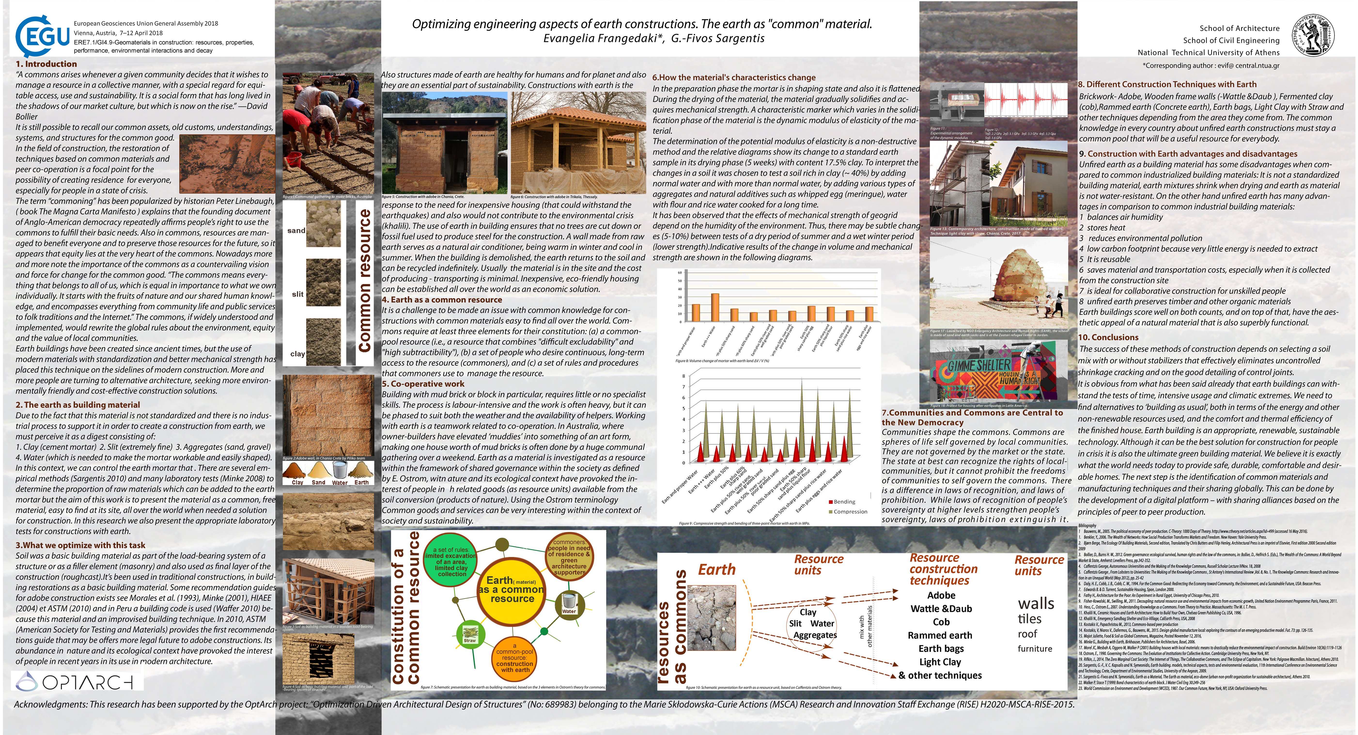
-
G.-F. Sargentis, E. Frangedaki, P. Dimitriadis, and D. Koutsoyiannis, Development of a web platform of knowledge exchange for optimal selection of building materials based on ecological criteria, European Geosciences Union General Assembly 2019, Geophysical Research Abstracts, Vol. 21, Vienna, EGU2019-10395, European Geosciences Union, 2019.
Decisions on technical issues must simultaneously satisfy several conflicting objectives. Several methods have been developed to help identify the "optimal" decision. Such decisions are made by politicians but experts, constructors and the society must have the ability to overview and influence these decisions. The interaction of the different groups can be implemented using a web platform. The criteria to optimize this platform and its architecture are analysed. The aim is to give to non-expert users a general view of the problem and the solutions suggested, and help them form an informed opinion on a technical problem. At the same time it would help politicians and experts to take into account the public opinions in decision making.
Remarks:
This research has been supported by the OptArch project: "Optimization Driven Architectural Design of Structures" (No: 689983) belonging to the Marie Skłodowska-Curie Actions (MSCA) Research and Innovation Staff Exchange (RISE) H2020-MSCA-RISE-2015.
Full text:
- http://www.itia.ntua.gr/en/getfile/1948/1/documents/EGU2019-10395.pdf: Abstract (32 KB)
- http://www.itia.ntua.gr/en/getfile/1948/2/documents/3_platform_20190320.pdf: Poster (3981 KB)
-
Μ. Sako, E. Tsoli, R. Ioannidis, E. Frangedaki, G.-F. Sargentis, and D. Koutsoyiannis, Optimizing the size of Hilarion dam with technical, economical and environmental parameters, European Geosciences Union General Assembly 2019, Geophysical Research Abstracts, Vol. 21, Vienna, EGU2019-15297, European Geosciences Union, 2019.
The construction and operation of large dams has been questioned in recent years as, despite their positive effect on the economy, they are regarded as negative to the environment. The size of a dam, in particular, is an important aspect of this debate as it is thought to increase its economic benefit but also its environmental impacts. We investigate the dam scale issue based on a case study for the Hilarion dam, located in Kozani, Greece. More specifically, in an effort to examine the problem of optimal project scale, we quantify selected technical, economic and environmental parameters of the Hilarion dam for different hypothetical scenarios of dam size including its original size. The various scenarios are compared on a cost-benefit basis to provide a first approximation of the exact relation between dam size and its technical, environmental and economic characteristics.
Remarks:
This research has been supported by the OptArch project: "Optimization Driven Architectural Design of Structures" (No: 689983) belonging to the Marie Skłodowska-Curie Actions (MSCA) Research and Innovation Staff Exchange (RISE) H2020-MSCA-RISE-2015.
Full text:
- http://www.itia.ntua.gr/en/getfile/1947/1/documents/EGU2019-15297.pdf: Abstract (32 KB)
- http://www.itia.ntua.gr/en/getfile/1947/2/documents/2_dam_20190403.pdf: Poster (4356 KB)
-
R. Ioannidis, P. Dimitriadis, G.-F. Sargentis, E. Frangedaki, T. Iliopoulou, and D. Koutsoyiannis, Stochastic similarities between hydrometeorogical and art processes for optimizing architecture and landscape aesthetic parameters, European Geosciences Union General Assembly 2019, Geophysical Research Abstracts, Vol. 21, Vienna, EGU2019-11403, European Geosciences Union, 2019.
Stochastics help develop a unified perception for natural phenomena and expel dichotomies like random vs. deterministic, as both randomness and predictability coexist and are intrinsic to natural systems which can be deterministic and random at the same time, depending on the prediction horizon and the time scale. The high complexity and uncertainty of natural processes has been long identified through observations as well as extended analyses of hydrometeorological processes such as temperature, humidity, surface wind, precipitation, atmospheric pressure, river discharges etc. All these processes seem to exhibit high unpredictability due to the clustering of events. Art is a mix of determinism (e.g., certain rules have to be followed) and stochasticity (e.g., creativity and inspiration). However, in this analysis we analyse each artistic work in a stochastic approach, and attempt to identify their degree of intrinsic uncertainty. The stochastic analysis includes the investigation of possible Hurst-Kolmogorov behaviour in the art of different periods (visual arts, music, poetry) and of relationships with natural processes. Based on the stochastic analysis of different artworks, we make an image analysis of architectural elements in the landscape in order to formulate an indicator that can be used in engineering.
Remarks:
This research has been supported by the OptArch project: "Optimization Driven Architectural Design of Structures" (No: 689983) belonging to the Marie Skłodowska-Curie Actions (MSCA) Research and Innovation Staff Exchange (RISE) H2020-MSCA-RISE-2015.
Full text:
- http://www.itia.ntua.gr/en/getfile/1946/1/documents/EGU2019-11403.pdf: Abstract (32 KB)
- http://www.itia.ntua.gr/en/getfile/1946/2/documents/1_landscape_20190402.pdf: Poster (5658 KB)
-
G.-F. Sargentis, R. Ioannidis, G. Karakatsanis, and D. Koutsoyiannis, The scale of infrastructures as a social decision. Case study: dams in Greece, European Geosciences Union General Assembly 2018, Geophysical Research Abstracts, Vol. 20, Vienna, EGU2018-17082, European Geosciences Union, 2018.
Organized societies require specific infrastructures, among which hydraulic projects are most important. Thus, for the functioning of a society, the water supply and drainage are prerequisites, while a new modern society also needs renewable energy in addition to, and in connection with, high quality water. Dams are key infrastructures in this process. Modern economic and social conditions do not define the limits of what we call "development". In this research we are mapping the limits of the development based on the capacity of the landscape, the water resources, the finances, the political aspects and the criteria of a city’s development.
Full text:
- http://www.itia.ntua.gr/en/getfile/1812/1/documents/EGU2018-17082.pdf: Abstract (30 KB)
- http://www.itia.ntua.gr/en/getfile/1812/2/documents/2018_EGU_Dams.pdf: Poster (1529 KB)
-
G.-F. Sargentis, P. Dimitriadis, T. Iliopoulou, R. Ioannidis, and D. Koutsoyiannis, Stochastic investigation of the Hurst-Kolmogorov behaviour in arts, European Geosciences Union General Assembly 2018, Geophysical Research Abstracts, Vol. 20, Vienna, EGU2018-17740-1, European Geosciences Union, 2018.
The Hurst-Kolmogorov (HK) behaviour (i.e. power-law decrease of the process variance vs. scale of averaging) has been already identified in numerous geophysical processes highlighting the large uncertainty of Nature in all time scales. In this study, we investigate through the climacogram whether or not some art works (such as paintings, music pieces and poems) also exhibit this behaviour and try to interpret the results in terms of (un)predictability in works of art.
Full text:
- http://www.itia.ntua.gr/en/getfile/1811/1/documents/EGU2018-17740-1.pdf: Abstract (30 KB)
- http://www.itia.ntua.gr/en/getfile/1811/2/documents/stochastic_art_.pdf: Poster (598 KB)
-
A. Efstratiadis, D. Koutsoyiannis, K. Hadjibiros, A. Andreadakis, A. Stamou, A. Katsiri, G.-F. Sargentis, and A. Christofides, A multicriteria approach for the sustainable management of the Plastiras reservoir, Greece, EGS-AGU-EUG Joint Assembly, Geophysical Research Abstracts, Vol. 5, Nice, doi:10.13140/RG.2.2.23631.48801, European Geophysical Society, 2003.
The Plastiras reservoir, sited in Western Thessaly, Greece, is a multipurpose project used for irrigation, water supply, hydropower, and recreation; the importance of the latter is continuously increasing as the reservoir landscape becomes attractive to tourists. These uses are competitive and result in a particularly complex problem of water management. Recently, a multidisciplinary analysis was attempted, aiming at determining a rational and sustainable management policy for the Plastiras Lake. This consists of establishing a minimum allowable water level for abstractions, in addition to a proper release policy. Until now, the reservoir level has had a 16 m fluctuation range, affecting negatively both the landscape, due to the exposure of the dead (no-vegetation) zone and the water quality. Three types of analyses were employed, to determine the variation of the corresponding criteria as a function of the allowable minimum level. The first one was the annual safe yield for various reliability levels, derived through a stochastic simulation model for the reservoir operation. The second criterion was the average summer concentration of chlorophyll-a (as indicator of the eutrophic regime of the lake), estimated through a one-dimensional eutrophication model. The final criterion was the aesthetics of the landscape; the relative study was focused on the effects of level variation and determined five fluctuation zones to characterise the quality of the landscape. After multiobjective analysis, and in cooperation with the local authorities and the public, a specific value of the minimum allowable level and a release policy were selected, which are currently on the way to be formally legislated.
Full text:
- http://www.itia.ntua.gr/en/getfile/568/1/documents/2003EGSPlastirasAbs.pdf: Abstract (11 KB)
- http://www.itia.ntua.gr/en/getfile/568/2/documents/2003EGSPlastiras.pdf: Poster (A0, in colour) (504 KB)
- http://www.itia.ntua.gr/en/getfile/568/3/documents/2003EGSPlastirasSM.pdf: Poster (reduced to A4, B/W) (269 KB)
See also: http://dx.doi.org/10.13140/RG.2.2.23631.48801
Other works that reference this work (this list might be obsolete):
1. Gounaridis, D., and G. N. Zaimes, GIS-based multicriteria decision analysis applied for environmental issues: the Greek experience, International Journal of Applied Environmental Sciences, 7(3), 307–321, 2012.
-
S. Sigourou, V. Pagana, P. Dimitriadis, A. Tsouni, T. Iliopoulou, G.-F. Sargentis, R. Ioannidis, E. Chardavellas, D. Dimitrakopoulou, N. Mamassis, C. Kontoes, and D. Koutsoyiannis, Flood risk assessment in the region of Attica, 9th International Conference on Civil Protection & New Technologies - Safe Thessaloniki 2022, Thessaloniki, Greece, September 2022.
Full text: http://www.itia.ntua.gr/en/getfile/2238/1/documents/2022-09-29-FLOOD_RISK_ASSESSMENT_IN_THE_REGION_OF_ATTICA-presentation.pdf (8756 KB)
-
S. Sigourou, V. Pagana, P. Dimitriadis, A. Tsouni, T. Iliopoulou, G.-F. Sargentis, R. Ioannidis, E. Chardavellas, D. Dimitrakopoulou, N. Mamassis, C. Kontoes, and D. Koutsoyiannis, Proposed methodology for urban flood-risk assessment at river-basin level: the case study of the Pikrodafni river basin in Athens, Greece, Global Flood Partnership 2022 Annual Meeting, Leeds, UK, September 2022.
The need for and the complexity of flood protection works require the development of advanced methodologies for flood risk assessment, especially considering that land cover changes, climate change and human interventions in the riverbed may severely affect the river flow. In the present study, a new methodology for urban flood risk assessment is introduced and implemented at the Pikrodafni river basin (Athens, Greece), by analyzing the vulnerability and the exposure of the river basin of Pikrodafni’s river to flood risk, in conjunction with the actual physical and socioeconomic parameters in order to propose mitigation measures. In March 2021, a Programming Agreement was signed between the Prefecture of Attica and the NOA – Part A – to conduct the study entitled ARIA «Earthquake, Fire and Flood risk assessment in the region of Attica» funded by the Prefecture of Attica. It’s the first time that such a holistic approach for flood risk assessment is implemented on building-block scale in Greece. The prototype knowledge created through the project supports the Prefecture of Attica in the optimum implementation of the National Civil Protection Plan. This serves the operational needs during crisis, as well as the preparedness and the strategic decision making towards disaster resilience. All the above-mentioned factors were also confirmed and positively evaluated according to the stakeholders’ feedback.
Full text: http://www.itia.ntua.gr/en/getfile/2237/1/documents/FINposter_Proposed_methodology_for_urban_flood-risk_assessment.pdf (5618 KB)
Presentations and publications in workshops
-
D. Koutsoyiannis, T. Iliopoulou, and G.-F. Sargentis, K-moments and their application to ombrian modelling, Invited lecture, Università di Bologna, Bologna, 2026.
K-moments, or knowable moments, provide a robust framework for high-order statistical characterization of stochastic variables. They are defined through expectations of order statistics (maxima or minima) that remain reliably estimable even from limited samples. Unlike conventional moments or L-moments, they effectively mitigate tail sensitivity, sampling variability, and the influence of long-range dependence. This presentation explores their theoretical foundations and practical advantages in ombrian modelling — the stochastic representation of rainfall intensity across multiple timescales through ombrian curves (previously and erroneously termed intensity-duration-frequency or IDF relationships). Applications demonstrate improved fitting of local and regional rainfall data, more accurate design storm estimation, and superior handling of extremes in hydrological practice.
Full text: http://www.itia.ntua.gr/en/getfile/2607/1/documents/2026BolognaKMoments5.pdf (2829 KB)
-
N. Mamassis, G.-F. Sargentis, and D. Koutsoyiannis, Temporal evolution of the electric energy mix in Greece: From development to dependence, 11th Conference: "Theories, research and actions for the regeneration of mountainous and isolated areas", Metsovo, 19 pages, Metsovo, September 2025.
The technology of electricity arrived in Greece in 1889, with power generation relying on lignite, hydroelectric projects, and oil. Until 1950, private units supplied cities without an extensive grid. In 1950, the Public Power Corporation (PPC) was established, absorbing private companies and building units and networks. Viewing electricity as a social good, PPC electrified remote areas at low prices, contributing to development. The EU's neoliberal policy brought privatizations, including in the energy market. In 1999, the energy market was liberalized, and PPC was privatized. Subsequently, private natural gas and wind energy units emerged, while in 2012-13, the share of photovoltaics in the energy mix surged. The energy exchange, that followed, caused distortions and losses for PPC. The year 2050 is the final year referenced in the National Energy and Climate Plan (Ministry of Environment and Energy, 2024). The plan outlines the evolution of the energy mix over the next 25 years. Studying this evolution reveals long-term policies aimed at turning a social good into a commodity. Today, the country's dependence on imported fuels and the commodification of energy have led to high prices that harm the population. Unfortunately, the future looks bleak, as the National Plan foreshadows policies that will make the situation even more unfavorable.
Full text: http://www.itia.ntua.gr/en/getfile/2564/1/documents/mamassis_et_al_fin.pdf (1008 KB)
Additional material:
- http://www.itia.ntua.gr/en/getfile/2564/2/documents/mets_9_25.pdf: Presentation (1994 KB)
-
G.-F. Sargentis, P. Defteraios, N. D. Lagaros, and N. Mamassis, Values and costs in history, Stuff we don't mention in the normal course of studies, Rovies, National Technical University of Athens (NTUA), 2023.
Full text: http://www.itia.ntua.gr/en/getfile/2332/1/documents/rovies-2023-sargentis-et-al-values.pdf (1798 KB)
-
G.-F. Sargentis, R. Ioannidis, E. Frangedaki, P. Dimitriadis, T. Iliopoulou, D. Koutsoyiannis, and N. D. Lagaros, Wildfires, Stuff we don't mention in the normal course of studies, Rovies, National Technical University of Athens (NTUA), 2023.
Full text: http://www.itia.ntua.gr/en/getfile/2331/1/documents/rovies-2023-sargentis-et-al-fires.pdf (2624 KB)
-
D. Koutsoyiannis, and G.-F. Sargentis, Entropy and Wealth_1, Stuff we don't mention in the normal course of studies, Rovies, National Technical University of Athens (NTUA), 2023.
Full text: http://www.itia.ntua.gr/en/getfile/2330/1/documents/rovies-2023-koutsoyiannis-sargentis-entropy.pdf (2509 KB)
-
N. Mamassis, and G.-F. Sargentis, [No English title available], Stuff we don't mention in the normal course of studies, Rovies, National Technical University of Athens (NTUA), 2023.
Full text: http://www.itia.ntua.gr/en/getfile/2329/1/documents/rovies-2023-mamassis-sargentis-wef.pdf (1861 KB)
-
G.-F. Sargentis, Τhe feasibility of energy projects, Stuff we don't mention in the normal course of studies, Rovies, National Technical University of Athens (NTUA), 2023.
Full text: http://www.itia.ntua.gr/en/getfile/2328/1/documents/rovies-2023-fivos-sargentis-energy-poster.pdf (1493 KB)
-
G.-F. Sargentis, Wildfires. Case study: The fire in Euboea 2021, Stuff we don't mention in the normal course of studies, Rovies, National Technical University of Athens (NTUA), 2023.
Full text: http://www.itia.ntua.gr/en/getfile/2320/1/documents/rovies-2023-fivos-sargentis-fire.pdf (1807 KB)
-
G.-F. Sargentis, Feasibility of the RE infrastructures: The role of beauty, Stuff we don't mention in the normal course of studies, Rovies, National Technical University of Athens (NTUA), 2023.
Full text: http://www.itia.ntua.gr/en/getfile/2319/1/documents/rovies-2023-fivos-sargentis-feasibility.pdf (3522 KB)
-
G.-F. Sargentis, [No English title available], Stuff we don't mention in the normal course of studies, Rovies, National Technical University of Athens (NTUA), 2023.
Full text: http://www.itia.ntua.gr/en/getfile/2318/1/documents/rovies-2023-fivos-sargentis-wef.pdf (4983 KB)
-
G.-F. Sargentis, [No English title available], Stuff we don't mention in the normal course of studies, Rovies, National Technical University of Athens (NTUA), 2023.
Full text: http://www.itia.ntua.gr/en/getfile/2317/1/documents/rovies-2023-fivos-sargentis-population.pdf (6149 KB)
-
A. Tsouni, S. Sigourou, V. Pagana, D. Koutsoyiannis, N. Mamassis, A. Koukouvinos, P. Dimitriadis, T. Iliopoulou, G.-F. Sargentis, R. Ioannidis, D. Dimitrakopoulou, E. Chardavellas, S. Vavoulogiannis, and V. Kyriakouli, Flood risk assessment in the Pikrodafni basin, Presentation of results for the 1st Phase of the Program Agreement between Attica Regional Authority and NOA, Athens, National Observatory of Athens, 2022.
Full text: http://www.itia.ntua.gr/en/getfile/2190/1/documents/20220516.pdf (13374 KB)
Various publications
-
G.-F. Sargentis, The dynamics of rainwater in Naxos, 15 pages, National Technical University of Athens, Naxos, October 2025.
Full text: http://www.itia.ntua.gr/en/getfile/2577/1/documents/20251018_Watersens_fivos.pdf (1496 KB)
-
D. Koutsoyiannis, G.-F. Sargentis, N. Mamassis, and T. Iliopoulou, The importance of water in the historical development of science, Presentation for the Nishan Forum on Water Culture, doi:10.13140/RG.2.2.28165.67047, Qufu, China, July 2025.
In ancient Greece, Thales of Miletus declared water the fundamental element of life. For the first time in history, he studied a geophysical behaviour in scientific terms. This was the “Nile paradox”—why the Nile floods in summer, unlike other Mediterranean rivers. In China, scholars like Zou Yan, through the Five Elements theory and yin-yang, saw water as part of an interconnected system, essential to balance and renewal. Both cultures placed water at the heart of existence, sparking traditions of inquiry and observation. By rejecting divine explanations and seeking natural causes, Thales sparked a tradition of inquiry that culminated the final solution of the “Nile paradox” by Aristotle: the Nile’s floods were driven by monsoon rains in Ethiopia. For confirmation of his theory, the first scientific expedition in history was organized. This emphasis on empirical evidence and questioning assumptions can still be inspiring in the modern world. Aristotle also described how water evaporates, condenses, and returns as rain—noting that “the sea will never dry up” because water cycles continuously. He even made experiments, noting that salt water becomes fresh when evaporated. Similarly, China’s Taoist principles and the I Ching celebrate water’s cyclical flow, symbolizing harmony with nature. Practical ingenuity also defines both water cultures. In Greece, aqueducts were built in the 6th century BC, some enduring to this day. In China, the Dujiangyan irrigation system, constructed more than 2 000 years ago, remains a marvel of engineering, balancing human needs with the environment. These examples show us how to build resilient infrastructures. Both cultures valued clear thinking and harmony. Greek philosophers like Socrates and Aristotle sought precise understanding, much like Confucian ideals emphasize order and mutual respect. This common ground strengthens our ability to collaborate globally, ensuring that efforts to address water problems are holistic and effective. The water cultures of ancient Greece and China teach us to question assumptions, observe nature, build with resilience, and communicate clearly. By embracing these lessons, we can innovate and unite to prevent water disasters, enhance the benefits of water and restore ecosystems.
Full text: http://www.itia.ntua.gr/en/getfile/2545/1/documents/HistoricalDevelopmentOfScience_.pdf (2705 KB)
Additional material:
- http://www.itia.ntua.gr/en/getfile/2545/2/documents/Speech2.pdf: Related summary speech (157 KB)
-
G.-F. Sargentis, Does the water go to the city or the city to the water?, 43 pages, Athens, 2025.
Full text: http://www.itia.ntua.gr/en/getfile/2530/1/documents/emdydas_20250123.pdf (7515 KB)
-
G.-F. Sargentis, National Technical University of Athens, Infrastructure Evolution (up to 2010), 34 pages, National Technical University of Athens, Athens, 2025.
Full text: http://www.itia.ntua.gr/en/getfile/2529/1/documents/EVOLUTION_NTUA.pdf (3781 KB)
-
G.-F. Sargentis, Prometheus Pyrphorοs, 12 pages, National Technical University of Athens, Athens, 2025.
Full text: http://www.itia.ntua.gr/en/getfile/2527/1/documents/pyrforos_2025_bzlBN1b.pdf (2278 KB)
-
G.-F. Sargentis, Hercules of Farneze, 13 pages, National Technical University of Athens, Athens, 2025.
Full text: http://www.itia.ntua.gr/en/getfile/2526/1/documents/Hercules.pdf (3264 KB)
-
G.-F. Sargentis, The Averof building, 40 pages, National Technical University of Athens, Athens, 2025.
Full text: http://www.itia.ntua.gr/en/getfile/2525/1/documents/averof_2025_2.pdf (8656 KB)
-
G.-F. Sargentis, 700-bed hostels Zografou University Campus, 33 pages, National Technical University of Athens, Athens, 2025.
Full text: http://www.itia.ntua.gr/en/getfile/2524/1/documents/700-bed_hostels_at_the_Zografou_University_Campus_experience_dty.pdf (9514 KB)
-
G.-F. Sargentis, and R. Ioannidis, The effect of wind turbines in the landscape, Department of Water Resources and Environmental Engineering – National Technical University of Athens, 2023.
Full text: http://www.itia.ntua.gr/en/getfile/2368/1/documents/13_RE_and_beauty.pdf (3708 KB)
-
G.-F. Sargentis, The feasibility of Renewable Energy projects, Department of Water Resources and Environmental Engineering – National Technical University of Athens, 2023.
Full text: http://www.itia.ntua.gr/en/getfile/2367/1/documents/12_RE_feasibility_r4taQXM.pdf (3040 KB)
-
N. Mamassis, and G.-F. Sargentis, Instructions for the presentation in laboratory of humanitarian studies (section history), Department of Water Resources and Environmental Engineering – National Technical University of Athens, 2023.
Full text: http://www.itia.ntua.gr/en/getfile/2366/1/documents/11_ergasies_ergastirio_anthropistikwn_spoudwn.pdf (1742 KB)
-
G.-F. Sargentis, The role of money in water-energy and food nexus, Department of Water Resources and Environmental Engineering – National Technical University of Athens, 2023.
Full text: http://www.itia.ntua.gr/en/getfile/2365/1/documents/10_money_energy.pdf (745 KB)
-
N. Mamassis, and G.-F. Sargentis, The subjectivity of money, Department of Water Resources and Environmental Engineering – National Technical University of Athens, 2023.
Full text: http://www.itia.ntua.gr/en/getfile/2364/1/documents/09_money_subjectivity.pdf (344 KB)
-
N. Mamassis, and G.-F. Sargentis, Money in history, Department of Water Resources and Environmental Engineering – National Technical University of Athens, 2023.
Full text: http://www.itia.ntua.gr/en/getfile/2363/1/documents/08_money_history.pdf (642 KB)
-
N. Mamassis, and G.-F. Sargentis, The role of food in prosperity, Department of Water Resources and Environmental Engineering – National Technical University of Athens, 2023.
Full text: http://www.itia.ntua.gr/en/getfile/2362/1/documents/07_wef_food.pdf (1088 KB)
-
N. Mamassis, and G.-F. Sargentis, The role of energy in prosperity, Department of Water Resources and Environmental Engineering – National Technical University of Athens, 2023.
Full text: http://www.itia.ntua.gr/en/getfile/2361/1/documents/06_wef_energy.pdf (1222 KB)
-
N. Mamassis, and G.-F. Sargentis, The role of water in prosperity, Department of Water Resources and Environmental Engineering – National Technical University of Athens, 2023.
Full text: http://www.itia.ntua.gr/en/getfile/2360/1/documents/05_wef_water.pdf (1083 KB)
-
G.-F. Sargentis, The role of water-energy-food nexus in prosperity, Department of Water Resources and Environmental Engineering – National Technical University of Athens, 2023.
Full text: http://www.itia.ntua.gr/en/getfile/2359/1/documents/04_wef_intro_20230512.pdf (340 KB)
-
N. Mamassis, and G.-F. Sargentis, Overpopulation and environmental determinism, Department of Water Resources and Environmental Engineering – National Technical University of Athens, 2023.
Full text: http://www.itia.ntua.gr/en/getfile/2358/1/documents/Environmental_Determinism.pdf (6310 KB)
-
N. Mamassis, and G.-F. Sargentis, The time as experience, 2023.
Full text: http://www.itia.ntua.gr/en/getfile/2357/1/documents/02_time_20230512.pdf (1538 KB)
-
G.-F. Sargentis, Which are the sources of our research and why are important?, Department of Water Resources and Environmental Engineering – National Technical University of Athens, 2023.
Full text: http://www.itia.ntua.gr/en/getfile/2356/1/documents/01_sources_20230512.pdf (2108 KB)
-
G.-F. Sargentis, The civil engineer. Technology for prosperity, Ionios School, Athens, 2023.
Full text: http://www.itia.ntua.gr/en/getfile/2277/1/documents/14_civil_engineer_2025.pdf (11747 KB)
-
G.-F. Sargentis, and N. Mamassis, Water collection in houses and complexes– Guidelines for the design in small scales, 75–80, 2021.
Full text: http://www.itia.ntua.gr/en/getfile/2131/1/documents/2021_ktirio_small_water.pdf (1076 KB)
-
G.-F. Sargentis, The role of technology in the water, energy and food grid, Department of Water Resources and Environmental Engineering – National Technical University of Athens.
Full text: http://www.itia.ntua.gr/en/getfile/2440/1/documents/15_WEF_Euboea.pdf (1022 KB)
Books
-
D. Koutsoyiannis, D. Liatis, L. Lazaridis, K. Lymperis, S. Kavounidis, S. Sthathopoulos, S. Lampropoulos, N. Moutafis, J. Stefanakos, C. Memos, P. Marinos, D. Ioakeim, C.P. Kostopanayiotis, A. Mizara, and G.-F. Sargentis, 130 Years School of Civil Engineering NTUA: Alma Mater of Greek Technology, Kleidarithmos, Athens, 2018.
Historical review of the infrastructure development of Greece, 1887-2017
Full text: http://www.itia.ntua.gr/en/getfile/2415/1/documents/EMP_Anniv_Book_Body.pdf (26007 KB)
Additional material:
- http://www.itia.ntua.gr/en/getfile/2415/2/documents/00_0_Cover.jpg: Cover (1759 KB)
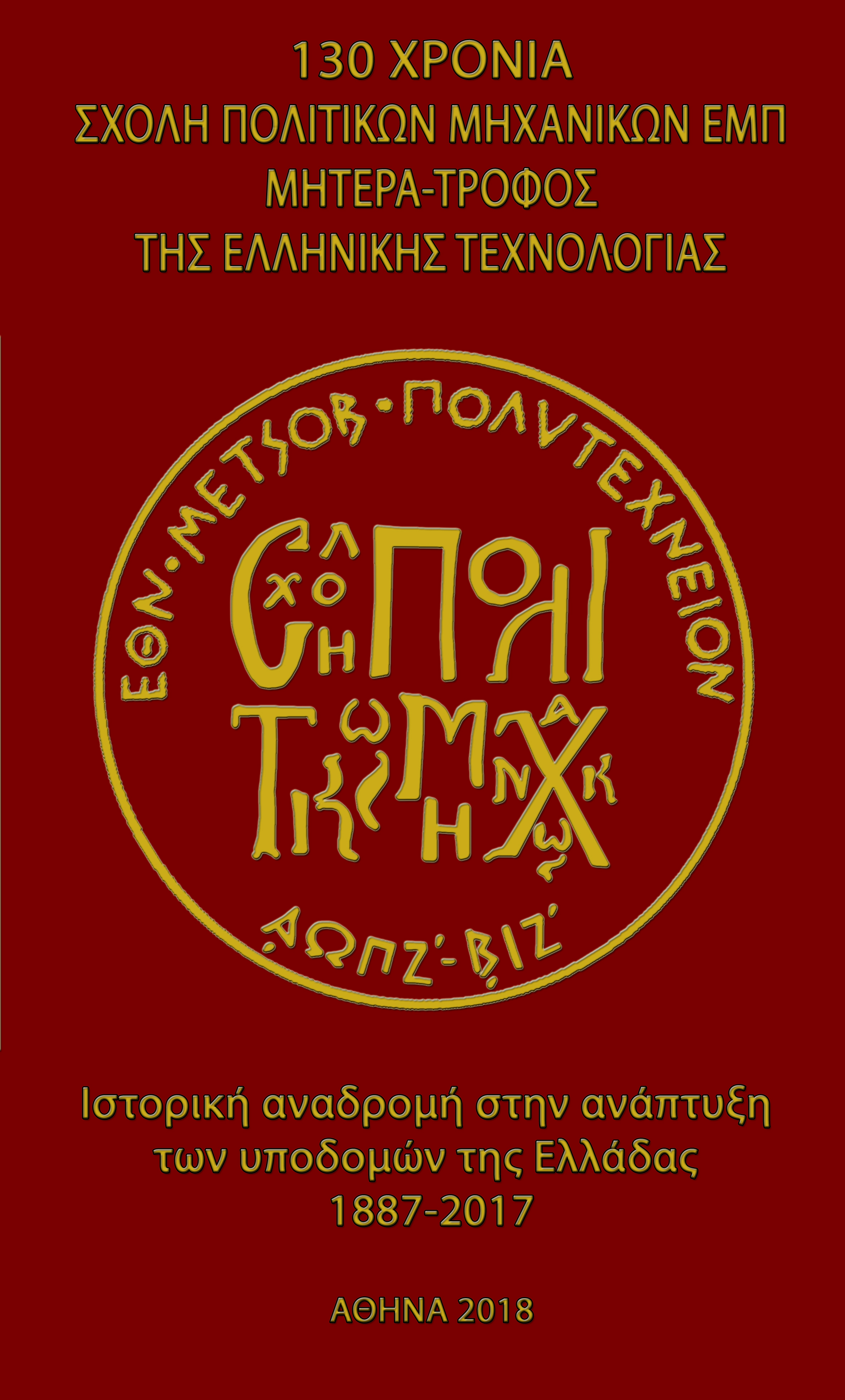
Educational notes
-
G.-F. Sargentis, and T. Iliopoulou, Water-Energy and Food nexus. Methodology of research, questions and databases, 14 pages, Athens, September 2025.
Full text: http://www.itia.ntua.gr/en/getfile/2566/1/documents/Water-Energy-Food_nexus.pdf (1240 KB)
-
G.-F. Sargentis, Technical projects and changes in the landscape, 82 pages, Athens, October 2024.
Full text: http://www.itia.ntua.gr/en/getfile/2495/1/documents/Technical_projects_and_changes_in_the_landscape.pdf (8496 KB)
-
D. Koutsoyiannis, M. Pantazidou, N. Mamassis, G.-F. Sargentis, P. Thanopoulos, S. Lampropoulos, D Vamvatsikos, and K. Hadjibiros, Lecture Notes for the Laboratory on Humanities, School of Civil Engineering – National Technical University of Athens, Athens, 2020.
Full text:
- http://www.itia.ntua.gr/en/getfile/2032/10/documents/ScientificMethod6.pdf: Historical and Philosophical Introduction to the Scientific Method (D. Koutsoyiannis) (3094 KB)
- http://www.itia.ntua.gr/en/getfile/2032/20/documents/2020-TexnikiGrafi-Meros1_.pdf: Technical writing: objectives, language, references (M. Pantazidou) (1432 KB)
- http://www.itia.ntua.gr/en/getfile/2032/30/documents/2020-TexnikiGrafi-Meros2_.pdf: Technical writing: Standard texts (M. Pantazidou) (512 KB)
- http://www.itia.ntua.gr/en/getfile/2032/40/documents/Presentation_History_20260405.pdf: The evolution of man in history. Technology and perceptions (N. Mamassis, G.-F. Sargentis) (37065 KB)
- http://www.itia.ntua.gr/en/getfile/2032/50/documents/PolitikhTexnologia_2020-2021.pdf: Politics and technology (P. Thanopoulos and S. Lampropoulos,) (3601 KB)
- http://www.itia.ntua.gr/en/getfile/2032/60/documents/HumanitiesLab_Part05_Ethics_GR-1.pdf: Engineering ethics (D. Vamvatsikos) (374 KB)
- http://www.itia.ntua.gr/en/getfile/2032/70/documents/Thomas_Hobbes3_20_2021.pdf: Natural and built environment (K. Hadjibiros) (1391 KB)
Additional material:
- http://www.itia.ntua.gr/en/getfile/2032/1/documents/FirstLessonQuestions2.pdf: Some introductory questions for the Humanities Laboratory (568 KB)
- http://www.itia.ntua.gr/en/getfile/2032/80/documents/Sources_of_research-3.pdf: Sources of research (2401 KB)
-
G.-F. Sargentis, Lecture notes on Environmental Impacts: The aesthetic element at dams, 28 pages, Department of Water Resources and Environmental Engineering – National Technical University of Athens, October 2019.
Full text: http://www.itia.ntua.gr/en/getfile/1995/1/documents/perivalon_aesthetics.pdf (3564 KB)
-
A. Efstratiadis, G.-F. Sargentis, and N. Mamassis, Lecture notes on Environmental Impacts: Analysis of environmental impacts from large hydraulic structures, 37 pages, Department of Water Resources and Environmental Engineering – National Technical University of Athens, October 2019.
Full text: http://www.itia.ntua.gr/en/getfile/1993/1/documents/EnvImpacts2019_HydroWorks.pdf (2930 KB)
-
A. Christofides, A. Efstratiadis, and G.-F. Sargentis, Presentation of the research project "Investigation of scenarios for the management and protection of the quality of the Plastiras Lake", 79 pages, 1 April 2003.
Remarks:
Slides from presentation in the postgraduate course "Environmental impacts of hydraulic works".
Full text:
- http://www.itia.ntua.gr/en/getfile/566/1/documents/2002PlastirasPres-1.pdf: Part 1: Introduction (68 KB)
- http://www.itia.ntua.gr/en/getfile/566/2/documents/2002PlastirasPres-2.pdf: Part 2: Hydrology and water quality (249 KB)
- http://www.itia.ntua.gr/en/getfile/566/3/documents/2002PlastirasPres-3.pdf: Part 3: Landscape quality (6442 KB)
- http://www.itia.ntua.gr/en/getfile/566/4/documents/2002PlastirasPres-4.pdf: Part 4: Conclusions (77 KB)
Academic works
-
G.-F. Sargentis, Issues of Prosperity: Stochastic evaluation of data related to environment, infrastructures, economy and society, PhD thesis, Department of Water Resources and Environmental Engineering – National Technical University of Athens, June 2022.
Full text: http://www.itia.ntua.gr/en/getfile/2259/1/documents/phd.pdf (13621 KB)
-
G.-F. Sargentis, The esthetic element in water, hydraulic works and dams, Diploma thesis, Department of Water Resources, Hydraulic and Maritime Engineering – National Technical University of Athens, Athens, 1998.
Full text: http://www.itia.ntua.gr/en/getfile/431/1/documents/1998sargentis.pdf (33830 KB)
Research reports
-
K. Hadjibiros, D. Koutsoyiannis, A. Andreadakis, A. Katsiri, A. Stamou, A. Valassopoulos, A. Efstratiadis, I. Katsiris, M. Kapetanaki, A. Koukouvinos, N. Mamassis, K. Noutsopoulos, G.-F. Sargentis, and A. Christofides, Overview report, Investigation of scenarios for the management and protection of the quality of the Plastiras Lake, Report 1, 23 pages, Department of Water Resources, Hydraulic and Maritime Engineering – National Technical University of Athens, Athens, March 2002.
The Plastiras Lake is a reservoir used for irrigation, water supply, hydropower, and tourism. These uses are competitive and result in an especially complex problem of water management. In this report the problem is presented and the main points of the three parts of the project are summarised; these three parts are the hydrological study, the quality study, and the landscape study. The conflicting demands are arranged, and water release scenarios are suggested.
Related project: Investigation of scenarios for the management and protection of the quality of the Plastiras Lake
Full text:
- http://www.itia.ntua.gr/en/getfile/490/1/documents/2002PlastirasFinal_h.pdf: Normal version (1164 KB)
- http://www.itia.ntua.gr/en/getfile/490/2/documents/2002PlastirasFinal_l.pdf: Compact version, with low quality in figures (490 KB)
Other works that reference this work (this list might be obsolete):
1. Andreadakis, A., K. Noutsopoulos, and E. Gavalaki, Assessment of the water quality of Lake Plastira through mathematical modelling for alternative management scenarios, Global Nest: the International Journal, 5(2), pp 99-105, 2003. 2. #Karalis, S. and A . Chioni, 1-D Hydrodynamic modeling of Greek lakes and reservoirs, Ch. 59 in Environmental Hydraulics, Proceedings of the 6th International Symposium on Environmental Hydraulics (ed. by A. I . Stamou), Athens, Greece, 397–401, 2010. 3. Kalavrouziotis, I. K., A. Τ. Filintas, P. H. Koukoulakis, and J. N. Hatzopoulos, Application of multicriteria analysis in the management and planning of treated municipal wastewater and sludge reuse in agriculture and land development: the case of Sparti’s wastewater treatment plant, Greece, Fresenius Environmental Bulletin, 20(2), 287-295, 2011.
-
G.-F. Sargentis, and A. Christofides, The landscape, Investigation of scenarios for the management and protection of the quality of the Plastiras Lake, Report 4, 73 pages, Department of Water Resources, Hydraulic and Maritime Engineering – National Technical University of Athens, Athens, March 2002.
The level of Lake Plastira varies widely due to water release. Specifically, the level varies from 792 m, which is spill level, to 776 m, which is the lowest level. This variation affects the landscape to a high degree. In this report the aesthetics of the landscape of Lake Plastira is examined, focusing on the effects of level variation. The conclusion is that for levels around 786 m or greater, there are minimal effects on the landscape and virtually everyone finds it wonderful. For lower levels, down to about 782 m, the landscape is significantly affected, mostly due to the dead zone revealed by the lowering of the level; most first or second-time visitors find it beautiful, but many inhabitants of the area and people who visit it regularly anticipate problems. For even lower levels, only visitors who do not come regularly may find the landscape satisfactory, and only in a few observation points. Apart from level variation, other problems of the landscape are discussed, namely those resulting from development. Such problems concern roads, boats, buildings, signs, and light pollution, and it is concluded that the area must be protected. In addition, some preliminary suggestions are made concerning the creation of tourist attractions and infrastructure which should fit the character of the area.
Related project: Investigation of scenarios for the management and protection of the quality of the Plastiras Lake
Full text:
- http://www.itia.ntua.gr/en/getfile/489/1/documents/2002PlastirasLandscape_h.pdf: Normal version (13670 KB)
- http://www.itia.ntua.gr/en/getfile/489/2/documents/2002PlastirasLandscape_l.pdf: Compact version, with low quality in figures (1638 KB)
Miscellaneous works
-
G.-F. Sargentis, Art and Infrastructures, 84 pages, National Technical University of Athens, Athens, December 2025.
Full text: http://www.itia.ntua.gr/en/getfile/2580/1/documents/20251208_RE_and_beauty_erasmus_1.pdf (9657 KB)
-
G.-F. Sargentis, The synergies of the water-energy and food nexus, Agrenda, 1033, August 2025.
Full text: http://www.itia.ntua.gr/en/getfile/2563/1/documents/Water_Energy_Food_nexus.pdf (201 KB)