Nikos Mamassis
Professor, Surveying Engineer, Dr. Engineer
N.Mamassis@itia.ntua.gr
+30-2107722843
http://www.itia.ntua.gr/nikos/
Participation in research projects
Participation as Project Director
- Open Hydrosystem Information Network (OpenHi.net)
- Exploration of Hadrian aqueduct of Athens and recording of current state of specific underground parts
- Maintenance, upgrading and extension of the Decision Support System for the management of the Athens water resource system
- Development of Database and software applications in a web platform for the "National Databank for Hydrological and Meteorological Information"
- Development of a Geographical Information System and an Internet application for the supervision of Kephisos protected areas
Participation as Principal Investigator
- Development of computational infrastructure for the hydrodynamic simulation of the hydrosystem downstream of Asomata Dam
- Combined REnewable Systems for Sustainable ENergy DevelOpment (CRESSENDO)
- DEUCALION – Assessment of flood flows in Greece under conditions of hydroclimatic variability: Development of physically-established conceptual-probabilistic framework and computational tools
- Investigation of management scenarios for the Smokovo reservoir
Participation as Researcher
- Cost of raw water of the water supply of Athens
- EU COST Action C22: Urban Flood Management
- Integrated Management of Hydrosystems in Conjunction with an Advanced Information System (ODYSSEUS)
- Modernisation of the supervision and management of the water resource system of Athens
- Classification of quantitative and qualitative parameters of the water resources of Greece - Phases 1 and 2
- Investigation of scenarios for the management and protection of the quality of the Plastiras Lake
- Assessment of sediment generation in Thriasio
- Appraisal of river sediment deposits in reservoirs of hydropower dams
- National databank for hydrological and meteorological information - Hydroscope 2000
- Evaluation of Management of the Water Resources of Sterea Hellas - Phase 3
- Evaluation of Management of the Water Resources of Sterea Hellas - Phases 1, 2, 3
- Systematisation of the raw data archive of surface and subsurface waters of the Ministry of Agriculture in Thessalia
- Classification of quantitative and qualitative parameters of the water resources of Greece using geographical information systems
- Hydroscope II - Creation of a National Databank for Hydrological and Meteorological Information
- Integrated management of the riparian ecosystem of the Sperhios river
- AFORISM: A comprehensive forecasting system for flood risk mitigation and control
- Hydroscope: Creation of a National Databank for Hydrological and Meteorological Information
- A pilot study for the water resources management of the Epirus water district
- Evaluation of Management of the Water Resources of Sterea Hellas - Phase 1
- A pilot study for the management of the Louros and Arachthos watersheds
- Appraisal of existing potential for improving the water supply of greater Athens - Phase 2
- Appraisal of existing potential for improving the water supply of greater Athens - Phase 1
- Hydrological investigation of the Thessalia water basin
Participation in engineering studies
- Σχέδιο Διαχείρισης Κινδύνων Πλημμύρας των Λεκανών Απορροής Ποταμών του Υδατικού Διαμερίσματος Κρήτης (GR13)
- Παροχή Συμβουλευτικών Υπηρεσιών για την Κατάρτιση του 2ου Σχεδίου Διαχείρισης Λεκάνης Απορροής Ποταμού της Κύπρου για την Εφαρμογή της Οδηγίας 2000/60/ΕΚ και για την Κατάρτιση του Σχεδίου Διαχείρισης Κινδύνων Πλημμύρας για την Εφαρμογή της Οδηγίας 2007/60
- Σχέδιο Διαχείρισης Κινδύνων Πλημμύρας των Λεκανών Απορροής Ποταμών του Υδατικού Διαμερίσματος Δυτικής Πελοποννήσου (GR01)
- Σχέδιο Διαχείρισης Κινδύνων Πλημμύρας των Λεκανών Απορροής Ποταμών του Υδατικού Διαμερίσματος Ανατολικής Πελοποννήσου (GR03)
- Σχέδιο Διαχείρισης Κινδύνων Πλημμύρας των Λεκανών Απορροής Ποταμών του Υδατικού Διαμερίσματος Βόρειας Πελοποννήσου (GR02)
- Investigation of the hydrographic network development in Mavro Vouno, Grammatiko, Attica, Greece
- Water supply works from Gadouras dam - Phase B
- Study of the management of Kephisos
- Delineation of the Arachthos River bed in the town of Arta
- Specific Technical Study for the Ecological Flow from the Dam of Stratos
- Μελέτες Διερεύνησης Προβλημάτων Άρδευσης και Δυνατότητας Κατασκευής Ταμιευτήρων Νομού Βοιωτίας
- Water resource management of the Integrated Tourist Development Area in Messenia
- Technical consulting for the floods of Lower Acheloos and Edesseos
- Diversion of the Soulou Stream for the Development of Lignite Exploitations of the Public Power Corporation in the Mine of Southern Field of Region Kozani-Ptolemais
- Hydrological and hydraulic study for the flood protection of the new railway in the region of Sperhios river
- Engineering consultant for the project "Water supply of Heracleio and Agios Nicolaos from the Aposelemis dam"
- Consultative service for the spring "Kephalovriso" in Kaloskope
- Complementary study of environmental impacts from the diversion of Acheloos to Thessaly
- Estimation of losses from DXX canal in the irrigation network of Lower Acheloos
- Concerted actions for the sector of environment in Santorine and Therasia islands
- Engineering study of the hydraulic project of old and new river bed of Peneios in Larisa
- Water resources management of the Evinos river basin and hydrogeological study of the Evinos karstic system
- Integrated study of the environmental impacts from Acheloos diversion
- Engineering study for improving the water supply of Athens with the construction of a dam at the Evinos River
Published work
Publications in scientific journals
- S. Sigourou, P. Dimitriadis, V. Pagana, A. Tsouni, T. Iliopoulou, G.-F. Sargentis, R. Ioannidis, D. Dimitrakopoulou, E. Chardavellas, N. Mamassis, D. Koutsoyiannis, and C. Kontoes, Developing an integrated methodology for flood-hazard assessment: application to the Pikrodafni River Basin (Attica, Greece), Frontiers in Built Environment, 12, 1768439, doi:10.3389/fbuil.2026.1768439, 2026.
- A. Tsouni, S. Sigourou, V. Pagana, M.-C. Tsoutsos, P. Dimitriadis, G.-F. Sargentis, T. Iliopoulou, R. Ioannidis, D. Dimitrakopoulou, E. Chardavellas, M.J. Alexopoulos, A. Koukouvinos, N. Mamassis, D. Koutsoyiannis, and C. Kontoes, Multiparameter flood risk assessment and management planning at high spatial resolution in the region of Attica, Greece, IEEE Journal of Selected Topics in Applied Earth Observations …, 18, 25966–25979, doi:10.1109/JSTARS.2025.3613569, 2025.
- G.-F. Sargentis, T. Iliopoulou, R. Ioannidis, M. Kougia, I. Benekos, P. Dimitriadis, A. Koukouvinos, D. Dimitrakopoulou, N. Mamassis, A. Tsouni, S. Sigourou, V. Pagana, C. Kontoes, and D. Koutsoyiannis, Technological Advances in Flood Risk Assessment and Related Operational Practices Since the 1970s: A Case Study in the Pikrodafni River of Attica, Water, 17(1) (112), doi:10.3390/w17010112, 2025.
- P. Dimas, G.-K. Sakki, P. Kossieris, I. Tsoukalas, A. Efstratiadis, C. Makropoulos, N. Mamassis, and K. Pipili, Establishing a strategic blueprint for the design and evaluation of flood control infrastructure in extensive watersheds, Water Resources Management, 39, 2673–2700, doi:10.1007/s11269-024-04084-4, 2025.
- G.-F. Sargentis, N. Mamassis, and D. Koutsoyiannis, The multifaceted importance of mediterranean pine-tree forests to social cohesion. Energy, resin, grazing, and wildfire management in North Euboea, Greece, Natural Resources Conservation and Research, 7, 15 pages, 9962, doi:10.24294/nrcr9962, 2024.
- G.-F. Sargentis, R. Ioannidis, P. Dimitriadis, N. Malamos, O. Lyra, O. Kitsou, M. Kougia, N. Mamassis, and D. Koutsoyiannis, Energy Self-Sufficiency in Rural Areas; Case Study: North Euboea, Greece, Advances in Environmental and Engineering Research, 5 (4), 20 pages, doi:10.21926/aeer.2404025, 2024.
- G.-F. Sargentis, R. Ioannidis, N. Mamassis, V. Zoukos, and D. Koutsoyiannis, A review of the energy policy in Greece in the last 50 years and its implications for prosperity, Clean Energy and Sustainability, 2 (4), 10021, doi:10.70322/ces.2024.10021, 2024.
- G.-F. Sargentis, K. Moraiti, I. Benekos, R. Ioannidis, and N. Mamassis, Fast-Track Documentation of the Alterations on the Landscape, before and after a Natural Hazard—Case Study: North Euboea Greece before and after Storms Daniel and Elias, Rural and Regional Development, 2, 10016, doi:10.70322/rrd.2024.10016, 2024.
- K. Moraiti, S. Sigourou, P. Dimitriadis, R. Ioannidis, I. Benekos, T. Iliopoulou, O. Kitsou, N. Mamassis, D. Koutsoyiannis, and G.-F. Sargentis, Documenting the changing floodplain of Nileas Basin in North Euboea (Greece) before and after Storms Daniel and Elias, Rural and Regional Development, 2 (3), 10013, doi:10.35534/rrd.2024.10013, 2024.
- T. Iliopoulou, D. Koutsoyiannis, N. Malamos, A. Koukouvinos, P. Dimitriadis, N. Mamassis, N. Tepetidis, and D. Markantonis, A stochastic framework for rainfall intensity–time scale–return period relationships. Part ΙΙ: point modelling and regionalization over Greece, Hydrological Sciences Journal, 69 (8), 1092–1112, doi:10.1080/02626667.2024.2345814, 2024.
- E. Dimitriou, A. Efstratiadis, I. Zotou, A. Papadopoulos, T. Iliopoulou, G.-K. Sakki, K. Mazi, E. Rozos, A. Koukouvinos, A. D. Koussis, N. Mamassis, and D. Koutsoyiannis, Post-analysis of Daniel extreme flood event in Thessaly, Central Greece: Practical lessons and the value of state-of-the-art water monitoring networks, Water, 16 (7), 980, doi:10.3390/w16070980, 2024.
- G.-F. Sargentis, N. Mamassis, O. Kitsou, and D. Koutsoyiannis, The role of technology in the water–energy–food nexus. A case study: Kerinthos, North Euboea, Greece, Frontiers in Water, 6, 1343344, doi:10.3389/frwa.2024.1343344, 2024.
- D. Koutsoyiannis, T. Iliopoulou, A. Koukouvinos, N. Malamos, N. Mamassis, P. Dimitriadis, N. Tepetidis, and D. Markantonis, In search of climate crisis in Greece using hydrological data: 404 Not Found, Water, 15 (9), 1711, doi:10.3390/w15091711, 2023.
- D. Markantonis, G.-F. Sargentis, P. Dimitriadis, T. Iliopoulou, A. Siganou, K. Moraiti, M. Nikolinakou, I. Meletopoulos, N. Mamassis, and D. Koutsoyiannis, Stochastic Evaluation of the Investment Risk by the Scale of Water Infrastructures-Case Study: The Municipality of West Mani (Greece), World, 4 (1), 1–20, doi:10.3390/world4010001, 2022.
- T. Iliopoulou, P. Dimitriadis, A. Siganou, D. Markantonis, K. Moraiti, M. Nikolinakou, I. Meletopoulos, N. Mamassis, D. Koutsoyiannis, and G.-F. Sargentis, Modern use of traditional rainwater harvesting practices: An assessment of cisterns’ water supply potential in West Mani, Greece, Heritage, 5 (4), 2944–2954, doi:10.3390/heritage5040152, 2022.
- A. Koskinas, E. Zacharopoulou, G. Pouliasis, I. Deligiannis, P. Dimitriadis, T. Iliopoulou, N. Mamassis, and D. Koutsoyiannis, Estimating the Statistical Significance of Cross–Correlations between Hydroclimatic Processes in the Presence of Long–Range Dependence, Earth, 3 (3), 1027-1041, doi:10.3390/earth3030059, 2022.
- N. Mamassis, S. Chrisoulaki, Aim. Bedenmaxer-Gerousis, T. Evangelou , P. Koutis, G. Peppas, P. Defteraios, N. Zarkadoulas, D. Koutsoyiannis, and E. Griva, Representing the operation and evolution of ancient Piraeus’ water supply system, Water History, doi:10.1007/s12685-022-00299-7, May 2022.
- R. Ioannidis, N. Mamassis, A. Efstratiadis, and D. Koutsoyiannis, Reversing visibility analysis: Towards an accelerated a priori assessment of landscape impacts of renewable energy projects, Renewable and Sustainable Energy Reviews, 161, 112389, doi:10.1016/j.rser.2022.112389, 2022.
- N. Mamassis, K. Mazi, E. Dimitriou, D. Kalogeras, N. Malamos, S. Lykoudis, A. Koukouvinos, I. L. Tsirogiannis, I. Papageorgaki, A. Papadopoulos, Y. Panagopoulos, D. Koutsoyiannis, A. Christofides, A. Efstratiadis, G. Vitantzakis, N. Kappos, D. Katsanos, B. Psiloglou, E. Rozos, T. Kopania, I. Koletsis, and A. D. Koussis, OpenHi.net: A synergistically built, national-scale infrastructure for monitoring the surface waters of Greece, Water, 13 (19), 2779, doi:10.3390/w13192779, 2021.
- G.-F. Sargentis, T. Iliopoulou, P. Dimitriadis, N. Mamassis, and D. Koutsoyiannis, Stratification: An entropic view of society's structure, World, 2, 153–174, doi:10.3390/world2020011, 2021.
- D. Koutsoyiannis, and N. Mamassis, From mythology to science: the development of scientific hydrological concepts in the Greek antiquity and its relevance to modern hydrology, Hydrology and Earth System Sciences, 25, 2419–2444, doi:10.5194/hess-25-2419-2021, 2021.
- R. Ioannidis, T. Iliopoulou, C. Iliopoulou, L. Katikas, A. Petsou, M.-E. Merakou, M.-E. Asimomiti, N. Pelekanos, G. Koudouris, P. Dimitriadis, C. Plati, E. Vlahogianni, K. Kepaptsoglou, N. Mamassis, and D. Koutsoyiannis, Solar-powered bus route: introducing renewable energy into a university campus transport system, Advances in Geosciences, 49, doi:10.5194/adgeo-49-215-2019, 2019.
- G. Papacharalampous, H. Tyralis, A. Langousis, A. W. Jayawardena, B. Sivakumar, N. Mamassis, A. Montanari, and D. Koutsoyiannis, Probabilistic hydrological post-processing at scale: Why and how to apply machine-learning quantile regression algorithms, Water, doi:10.3390/w11102126, 2019.
- G. Koudouris, P. Dimitriadis, T. Iliopoulou, N. Mamassis, and D. Koutsoyiannis, A stochastic model for the hourly solar radiation process for application in renewable resources management, Advances in Geosciences, 45, 139–145, doi:10.5194/adgeo-45-139-2018, 2018.
- E. Klousakou, M. Chalakatevaki, P. Dimitriadis, T. Iliopoulou, R. Ioannidis, G. Karakatsanis, A. Efstratiadis, N. Mamassis, R. Tomani, E. Chardavellas, and D. Koutsoyiannis, A preliminary stochastic analysis of the uncertainty of natural processes related to renewable energy resources, Advances in Geosciences, 45, 193–199, doi:10.5194/adgeo-45-193-2018, 2018.
- H. Tyralis, G. Karakatsanis, K. Tzouka, and N. Mamassis, Data and code for the exploratory data analysis of the electrical energy demand in the time domain in Greece, Data in Brief, 13 (700-702), doi:http://dx.doi.org/10.1016/j.energy.2017.06.074, 2017.
- G. Koudouris, P. Dimitriadis, T. Iliopoulou, N. Mamassis, and D. Koutsoyiannis, Investigation on the stochastic nature of the solar radiation process, Energy Procedia, 125, 398–404, 2017.
- M. Chalakatevaki, P. Stamou, S. Karali, V. Daniil, P. Dimitriadis, K. Tzouka, T. Iliopoulou, D. Koutsoyiannis, P. Papanicolaou, and N. Mamassis, Creating the electric energy mix in a non-connected island, Energy Procedia, 125, 425–434, doi:10.1016/j.egypro.2017.08.089, 2017.
- H. Tyralis, G. Karakatsanis, K. Tzouka, and N. Mamassis, Exploratory data analysis of the electrical energy demand in the time domain in Greece, Energy, 134 (902-918), 16 pages, doi:10.1016/j.energy.2017.06.074 0360-5442, 2017.
- H. Tyralis, A. Tegos, A. Delichatsiou, N. Mamassis, and D. Koutsoyiannis, A perpetually interrupted interbasin water transfer as a modern Greek drama: Assessing the Acheloos to Pinios interbasin water transfer in the context of integrated water resources management, Open Water Journal, 4 (1), 113–128, 12, 2017.
- H. Tyralis, N. Mamassis, and Y. Photis, Spatial analysis of the electrical energy demand in Greece, Energy Policy, 102 (340-352), doi:10.1016/j.enpol.2016.12.033, March 2017.
- H. Tyralis, N. Mamassis, and Y. Photis, Spatial Analysis of Electrical Energy Demand Patterns in Greece: Application of a GIS-based Methodological Framework, Energy Procedia, 97 (262-269), 8 pages, doi:10.1016/j.egypro.2016.10.071, November 2016.
- K. Kollyropoulos, F. Georma, F. Saranti, N. Mamassis, and I. Kalavrouziotis, Urban planning and water management in Ancient Aetolian Makyneia, Western Greece, Water Science and Technology: Water Supply, 16 (5), doi:DOI: 10.2166/ws.2016.145 , September 2016.
- P. Dimitriadis, A. Tegos, A. Oikonomou, V. Pagana, A. Koukouvinos, N. Mamassis, D. Koutsoyiannis, and A. Efstratiadis, Comparative evaluation of 1D and quasi-2D hydraulic models based on benchmark and real-world applications for uncertainty assessment in flood mapping, Journal of Hydrology, 534, 478–492, doi:10.1016/j.jhydrol.2016.01.020, 2016.
- A. Tegos, A. Efstratiadis, N. Malamos, N. Mamassis, and D. Koutsoyiannis, Evaluation of a parametric approach for estimating potential evapotranspiration across different climates, Agriculture and Agricultural Science Procedia, 4, 2–9, doi:10.1016/j.aaspro.2015.03.002, 2015.
- N. Mamassis, S. Moustakas, and N. Zarkadoulas, Representing the operation of ancient reclamation works at Lake Copais in Greece, Water History, doi:10.1007/s12685-015-0126-x, 2015.
- A. N. Angelakis, N. Mamassis, E. Dialynas, and P. Defteraios, Urban Water Supply, Wastewater, and Stormwater Considerations in Ancient Hellas: Lessons Learned, Environment and Natural Resources Research, 4 (3), doi:10.5539/enrr.v4n3p95, October 2014.
- N. Mamassis, D. Panagoulia, and A. Novcovic, Sensitivity analysis of Penman evaporation method, Global Network for Environmental Science and Technology, 16 (4), 628–639, 2014.
- K. Zotalis, E. Dialynas, N. Mamassis, and A. N. Angelakis, Desalination Technologies: Hellenic Experience, Water, 6 (5), 1134–1150, doi:10.3390/w6051134, 30 April 2014.
- A. Efstratiadis, A. D. Koussis, D. Koutsoyiannis, and N. Mamassis, Flood design recipes vs. reality: can predictions for ungauged basins be trusted?, Natural Hazards and Earth System Sciences, 14, 1417–1428, doi:10.5194/nhess-14-1417-2014, 2014.
- N. Efthimiou, S. Alexandris, C Karavitis, and N. Mamassis, Comparative analysis of reference evapotranspiration estimation between various methods and the FAO56 Penman - Monteith procedure, European Water, 42 (19-34), 2013.
- C. Papathanasiou, D. Serbis, and N. Mamassis, Flood mitigation at the downstream areas of a transboundary river, Water Utility Journal, 3, 33–42, 2013.
- E. Kountouri, N. Petrochilos, N. Liaros, V. Oikonomou, D. Koutsoyiannis, N. Mamassis, N. Zarkadoulas, A. Vött, H. Hadler, P. Henning, and T. Willershäuser, The Mycenaean drainage works of north Kopais, Greece: a new project incorporating surface surveys, geophysical research and excavation, Water Science and Technology: Water Supply, 13 (3), 710–718, doi:10.2166/ws.2013.110, 2013.
- N. Mamassis, A. Efstratiadis, and E. Apostolidou, Topography-adjusted solar radiation indices and their importance in hydrology, Hydrological Sciences Journal, 57 (4), 756–775, doi:10.1080/02626667.2012.670703, 2012.
- D. Koutsoyiannis, A. Christofides, A. Efstratiadis, G. G. Anagnostopoulos, and N. Mamassis, Scientific dialogue on climate: is it giving black eyes or opening closed eyes? Reply to “A black eye for the Hydrological Sciences Journal” by D. Huard, Hydrological Sciences Journal, 56 (7), 1334–1339, doi:10.1080/02626667.2011.610759, 2011.
- G. G. Anagnostopoulos, D. Koutsoyiannis, A. Christofides, A. Efstratiadis, and N. Mamassis, A comparison of local and aggregated climate model outputs with observed data, Hydrological Sciences Journal, 55 (7), 1094–1110, doi:10.1080/02626667.2010.513518, 2010.
- G. Papathopoulou, E. Georgiou, N. Mamassis, and M. Mimikou, Estimation of areal distribution of climatic and bioclimatic indices in Attica region using the METEONET Network data, Technica Chronica, I, Athens, January 2009.
- D. Koutsoyiannis, C. Makropoulos, A. Langousis, S. Baki, A. Efstratiadis, A. Christofides, G. Karavokiros, and N. Mamassis, Climate, hydrology, energy, water: recognizing uncertainty and seeking sustainability, Hydrology and Earth System Sciences, 13, 247–257, doi:10.5194/hess-13-247-2009, 2009.
- D. Koutsoyiannis, A. Efstratiadis, N. Mamassis, and A. Christofides, On the credibility of climate predictions, Hydrological Sciences Journal, 53 (4), 671–684, doi:10.1623/hysj.53.4.671, 2008.
- A. Tsouni, C. Kontoes, D. Koutsoyiannis, P. Elias, and N. Mamassis, Estimation of actual evapotranspiration by remote sensing: Application in Thessaly Plain, Greece, Sensors, 8 (6), 3586–3600, 2008.
- D. Koutsoyiannis, N. Mamassis, and A. Tegos, Logical and illogical exegeses of hydrometeorological phenomena in ancient Greece, Water Science and Technology: Water Supply, 7 (1), 13–22, 2007.
- K Mantoudi, N. Mamassis, and D. Koutsoyiannis, Water basin balance model using a geographical information system, Technica Chronica, 24 (1-3), 43–52, 2004.
- D. Koutsoyiannis, G. Karavokiros, A. Efstratiadis, N. Mamassis, A. Koukouvinos, and A. Christofides, A decision support system for the management of the water resource system of Athens, Physics and Chemistry of the Earth, 28 (14-15), 599–609, doi:10.1016/S1474-7065(03)00106-2, 2003.
- D. Koutsoyiannis, and N. Mamassis, On the representation of hyetograph characteristics by stochastic rainfall models, Journal of Hydrology, 251, 65–87, 2001.
- N. Mamassis, and D. Koutsoyiannis, Influence of atmospheric circulation types in space-time distribution of intense rainfall, Journal of Geophysical Research-Atmospheres, 101 (D21), 26267–26276, 1996.
Book chapters and fully evaluated conference publications
- A. Tsouni, C.F. Panagiotou, S. Sigourou, J. Kountouri, V. Pagana, P. Dimitriadis, N. Mamassis, D. Koutsoyiannis, E. Hadjimitsis, and C. Kontoes, A transferable multicriteria flood risk assessment methodology at high spatial resolution: two case studies in Greece and Cyprus, IEEE International Symposium on Geoscience and Remote Sensing (IGARSS), doi:10.1109/IGARSS55030.2025.11242478, IEEE, Brisbane, Australia, 2025.
- G.-F. Sargentis, R. Ioannidis, M. Kougia, I. Benekos, T. Iliopoulou, P. Dimitriadis, A. Koukouvinos, D. Dimitrakopoulou, N. Mamassis, A. Tsouni, S. Sigourou, V. Pagana, E. Frangedaki, N. D. Lagaros, C. Kontoes, and D. Koutsoyiannis, The technological evolution in flood risk estimation, Proceedings of the International Conferences on Digital Technology Driven Engineering 2024, Irbid - Jordan, 225–235, Springer Nature, 2025.
- G.-F. Sargentis, R. Ioannidis, M. Kougia, I. Benekos, T. Iliopoulou, P. Dimitriadis, A. Koukouvinos, D. Dimitrakopoulou, N. Mamassis, A. Tsouni, S. Sigourou, V. Pagana, E. Frangedaki, N. D. Lagaros, C. Kontoes, and D. Koutsoyiannis, Do floods attack cities or cities invade flood plains?, Proceedings of the International Conferences on Digital Technology Driven Engineering 2024, Irbid - Jordan, 216–224, Springer Nature, 2025.
- A. Tsouni, S. Sigourou, V. Pagana, M.-C. Tsoutsos, P. Dimitriadis, G.-F. Sargentis, T. Iliopoulou, R. Ioannidis, D. Dimitrakopoulou, E. Chardavellas, M.J. Alexopoulos, A. Koukouvinos, N. Mamassis, D. Koutsoyiannis, and C. Kontoes, Multi-parameter flood risk assessment and management planning at high spatial resolution in the region of Attica, Greece, IGARSS 2024 - 2024 IEEE International Geoscience and Remote Sensing Symposium, Athens, Greece, doi:10.1109/IGARSS53475.2024.10642600, IEEE, 2024.
- D. Koutsoyiannis, T. Iliopoulou, A. Koukouvinos, N. Malamos, N. Mamassis, P. Dimitriadis, N. Tepetidis, and D. Markantonis, Extreme rainfall modelling for the design of hydraulic works and dams: the new methodology and its application in Greece [Invited talk], Proceedings of 4th Hellenic Conference on Dams and Reservoirs, War Museum Athens, doi:10.13140/RG.2.2.24009.35689, Hellenic Commission on Large Dams, Athens, 2024.
- R. Ioannidis, G.-F. Sargentis, A. Efstratiadis, N. Mamassis, and D. Koutsoyiannis, The challenge of integrating civil infrastructure acrosss landscapes and the importance of the architectural design of dams, Proceedings of 4th Hellenic Conference on Dams and Reservoirs, War Museum Athens, 127–137, Hellenic Commission on Large Dams, Athens, 2024.
- P. Dimas, N. Mamassis, A. Lykou, E. Zacharopoulou, G.-K. Sakki, T. Karantoumanis, A. Efstratiadis, and I. Mavros, Evaluation of management policies for hydropower plants in the light of flood risk at the downstream areas: the case of Aliakmon River, Proceedings of 4th Hellenic Conference on Dams and Reservoirs, War Museum Athens, 310–321, Hellenic Commission on Large Dams, Athens, 2024.
- P. Dimas, G.-K. Sakki, P. Kossieris, I. Tsoukalas, A. Efstratiadis, C. Makropoulos, N. Mamassis, and K. Pipili, Outlining a master plan framework for the design and assessment of flood mitigation infrastructures across large-scale watersheds, 12th World Congress on Water Resources and Environment (EWRA 2023) “Managing Water-Energy-Land-Food under Climatic, Environmental and Social Instability”, 75–76, European Water Resources Association, Thessaloniki, 2023.
- A. Tsouni, S. Antoniadi, E. Ieronimidi, K. Karagiannopoulou, N. Mamassis, D. Koutsoyiannis, and C. Kontoes, Multiparameter analysis of the flood of November 15, 2017 in west Attica using satellite remote sensing, Geoinformatics for Geosciences, doi:10.1016/B978-0-323-98983-1.00019-3, Elsevier, Oxford, UK, 2023.
- R. Ioannidis, N. Mamassis, K. Moraitis, and D. Koutsoyiannis, Proposals of spatial planning and architectural design for the sustainable integration of renewable energy works in the Greek landscape, Proceedings of the 10th Conference of MIRC - NTUA “Research and actions for the regeneration of mountainous and isolated areas”, Metsovo, 332–343, National Technical University of Athens, Metsovion Interdisciplinary Research Center, 2022.
- N. Mamassis, A. Efstratiadis, P. Dimitriadis, T. Iliopoulou, R. Ioannidis, and D. Koutsoyiannis, Water and Energy, Handbook of Water Resources Management: Discourses, Concepts and Examples, edited by J.J. Bogardi, T. Tingsanchali, K.D.W. Nandalal, J. Gupta, L. Salamé, R.R.P. van Nooijen, A.G. Kolechkina, N. Kumar, and A. Bhaduri, Chapter 20, 617–655, doi:10.1007/978-3-030-60147-8_20, Springer Nature, Switzerland, 2021.
- D. Koutsoyiannis, and N. Mamassis, The water supply of Athens through the centuries, Schriften der Deutschen Wasserhistorischen Gesellschaft, edited by K. Wellbrock, 27 (1), Siegburg, 2018.
- C. Nasika, S. Michas, and N. Mamassis, Application of Building Information Modeling (BIM) technologies in dam engineering, Proceedings of 3rd Hellenic Conference on Dams and Reservoirs, Zappeion, Hellenic Commission on Large Dams, Athens, 2017.
- P. Dimitriadis, A. Tegos, A. Petsiou, V. Pagana, I. Apostolopoulos, E. Vassilopoulos, M. Gini, A. D. Koussis, N. Mamassis, D. Koutsoyiannis, and P. Papanicolaou, Flood Directive implementation in Greece: Experiences and future improvements, 10th World Congress on Water Resources and Environment "Panta Rhei", Athens, European Water Resources Association, 2017.
- D. Serbis, C. Papathanasiou, and N. Mamassis, Irrigation challenges in NW Greece-Perspectives and solutions for flood prone areas, 14th International Conference on Environmental Science and Technology (CEST2015), Global Network on Environmental Science and Technology, University of the Aegean, 2015.
- S. Michas, A. Efstratiadis, K. Nikolaou, and N. Mamassis, Drought and water scarcity management plan for the Peloponnese river basin districts, 12th International Conference “Protection & Restoration of the Environment”, Skiathos, Dept. of Civil Engineering and Dept. of Planning & Regional Development, Univ. Thessaly, Stevens Instute of Technology, 2014.
- N. Mamassis, and D. Koutsoyiannis, Views on ancient Hellenic science and technology, IWA Regional Symposium on Water, Wastewater & Environment: Traditions & Culture, Patras, Greece, doi:10.13140/RG.2.1.2702.6163, International Water Association, 2014.
- N. Mamassis, and D. Koutsoyiannis, Information technologies in hydrometeorological data management in Greece, Honorary Edition for for Professor Emeritus D. Tolikas, edited by K. L. Katsifarakis and M. Vafiadis, 27–37, doi:10.13140/RG.2.1.1165.5928, Aristotle University of Thessaloniki, Thessaloniki, 2013.
- A. Efstratiadis, A. D. Koussis, S. Lykoudis, A. Koukouvinos, A. Christofides, G. Karavokiros, N. Kappos, N. Mamassis, and D. Koutsoyiannis, Hydrometeorological network for flood monitoring and modeling, Proceedings of First International Conference on Remote Sensing and Geoinformation of Environment, Paphos, Cyprus, 8795, 10-1–10-10, doi:10.1117/12.2028621, Society of Photo-Optical Instrumentation Engineers (SPIE), 2013.
- S. Kozanis, A. Christofides, N. Mamassis, and D. Koutsoyiannis, openmeteo.org: a web service for the dissemination of free meteorological data, Advances in Meteorology, Climatology and Atmospheric Physics, edited by C.G. Helmis and P. Nastos, Athens, 203–208, doi:10.1007/978-3-642-29172-2_29, Springer, Athens, 2012.
- D. Koutsoyiannis, N. Zarkadoulas, N. Mamassis, A. N. Angelakis, and L.W. Mays, The evolution of water supply throughout the millennia: A short overview, Evolution of Water Supply Through the Millennia, edited by A. N. Angelakis, L.W. Mays, D. Koutsoyiannis, and N. Mamassis, 21, 553–560, doi:10.13140/RG.2.1.2541.8485, IWA Publishing, London, 2012.
- N. Zarkadoulas, D. Koutsoyiannis, N. Mamassis, and A. N. Angelakis, A brief history of urban water management in ancient Greece, Evolution of Water Supply Through the Millennia, edited by A. N. Angelakis, L.W. Mays, D. Koutsoyiannis, and N. Mamassis, 10, 259–270, doi:10.13140/RG.2.1.4114.7127, IWA Publishing, London, 2012.
- A. N. Angelakis, L.W. Mays, D. Koutsoyiannis, and N. Mamassis, Prolegomena: The evolution of water supply through the millennia, Evolution of Water Supply Through the Millennia, edited by A. N. Angelakis, L.W. Mays, D. Koutsoyiannis, and N. Mamassis, xxi–xxii, doi:10.13140/RG.2.1.1542.4245, IWA Publishing, 2012.
- E. Kountouri, N. Petrochilos, D. Koutsoyiannis, N. Mamassis, N. Zarkadoulas, A. Vött, H. Hadler, P. Henning, and T. Willershäuser, A new project of surface survey, geophysical and excavation research of the mycenaean drainage works of the North Kopais: the first study season, 3rd IWA Specialized Conference on Water & Wastewater Technologies in Ancient Civilizations, Istanbul, Turkey, 467–476, doi:10.13140/RG.2.1.2328.8563, International Water Association, 2012.
- D. Koutsoyiannis, N. Mamassis, A. Efstratiadis, N. Zarkadoulas, and Y. Markonis, Floods in Greece, Changes of Flood Risk in Europe, edited by Z. W. Kundzewicz, Chapter 12, 238–256, IAHS Press, Wallingford – International Association of Hydrological Sciences, 2012.
- N. Mamassis, and D. Koutsoyiannis, A web based information system for the inspection of the hydraulic works in Ancient Greece, Ancient Water Technologies, edited by L.W. Mays, 103–114, doi:10.1007/978-90-481-8632-7_6, Springer, Dordrecht, 2010.
- N. Evelpidou, N. Mamassis, A. Vassilopoulos, C. Makropoulos, and D. Koutsoyiannis, Flooding in Athens: The Kephisos River flood event of 21-22/10/1994, International Conference on Urban Flood Management, Paris, doi:10.13140/RG.2.1.4065.5601, UNESCO, 2009.
- D. Koutsoyiannis, and N. Mamassis, New approaches to estimation of extreme rainfall, 1st Hellenic Conference on Large Dams, Larisa, 2, 433–440, doi:10.13140/RG.2.1.1116.4400, Hellenic Commission on Large Dams, Technical Chamber of Greece, 2008.
- N. Mamassis, and D. Koutsoyiannis, Physical, social and technological aspects of drought - The Athens example, Natural and Technological Disasters in Europe and Greece, edited by K. Sapountzaki, 61–88, doi:10.13140/RG.2.1.1640.7289, Gutenberg, Athens, 2007.
- N. Mamassis, V. Kanellopoulos, and D. Koutsoyiannis, A web based information system for the inspection of the hydraulic works in Ancient Greece, 5th International Symposium on Environmental Hydraulics, Tempe, Arizona, doi:10.13140/RG.2.1.3475.7362, International Association of Hydraulic Research, 2007.
- D. Koutsoyiannis, N. Mamassis, and A. Tegos, Logical and illogical exegeses of hydrometeorological phenomena in ancient Greece, Proceedings of the 1st IWA International Symposium on Water and Wastewater Technologies in Ancient Civilizations, edited by A. N. Angelakis and D. Koutsoyiannis, Iraklio, 135–143, doi:10.13140/RG.2.1.4188.4408, International Water Association, 2006.
- A. Grammatikoyiannis, N. Mamassis, E. Baltas, and M. Mimikou, A meteorological telemetric network for monitoring of the Athens wider area (Meteonet). A real time approach from point to areal measurements, Proceedings of the 9th International Conference on Environmental Science and Technology (9CEST), Rhodes, Department of Environmental Studies, University of the Aegean, 2005.
- N. Mamassis, A. Christofides, and D. Koutsoyiannis, Hydrometeorological data acquisition, management and analysis for the Athens water supply system, BALWOIS Conference on Water Observation and Information System for Decision Support, Ochrid, FYROM, doi:10.13140/RG.2.1.1845.5284, Ministry of Environment and Physical Planning FYROM, Skopie, 2004.
- A. Tsouni, D. Koutsoyiannis, C. Kontoes, N. Mamassis, and P. Elias, Estimation of actual evapotranspiration by remote sensing: Application in Thessalia plain, Greece, Proceedings of the International Conference "Geographical Information Systems and Remote Sensing: Environmental Applications", Volos, doi:10.13140/RG.2.1.3025.1763, 2003.
- N. Mamassis, and D. Koutsoyiannis, A hydrometeorological telemetric network for the water resources monitoring of the Athens water resource system, Proceedings of the 5th International Conference of European Water Resources Association: "Water Resources Management in the Era of Transition", edited by G. Tsakiris, Athens, 157–163, doi:10.13140/RG.2.1.3954.9683, European Water Resources Association, 2002.
- D. Koutsoyiannis, N. Mamassis, and A. Christofides, Experience from the operation of the automatic telemetric meteorological station in the National Technical University, Proceedings of the 8th National Congress of the Greek Hydrotechnical Association, edited by G. Christodoulou, A. Stamou, and A. Nanou, Athens, 301–308, doi:10.13140/RG.2.1.4577.5603, Greek Hydrotechnical Association, 2000.
- N. Mamassis, et D. Koutsoyiannis, Structure stochastique de pluies intenses par type de temps, Publications de l'Association Internationale de Climatologie, 6eme Colloque International de Climatologie, edité par P. Maheras, Thessaloniki, 6, 301–313, doi:10.13140/RG.2.1.3643.6726, Association Internationale de Climatologie, Aix-en-Provence Cedex, France, 1993.
- I. Nalbantis, N. Mamassis, et D. Koutsoyiannis, Le phénomène recent de sécheresse persistante et l' alimentation en eau de la cité d' Athènes, Publications de l'Association Internationale de Climatologie, 6eme Colloque International de Climatologie, edité par P. Maheras, Thessaloniki, 6, 123–132, doi:10.13140/RG.2.1.4430.1041, Association Internationale de Climatologie, Aix-en-Provence Cedex, France, 1993.
- D. Koutsoyiannis, C. Tsolakidis, and N. Mamassis, HYDRA-PC, A data base system for regional hydrological data management, Proceedings of the 1st European Conference on Advances in Water Resources Technology, Athens, 551–557, doi:10.13140/RG.2.1.4954.3921, Balkema, Rotterdam, 1991.
- N. Mamassis, Hydropower wealth of mountainous areas. The nodal position of Metsovo, 9th Conference by NTUA and MIRC: Vision, design and policy for the holistic development of mountainous and remote areas, Metsovo, National Technical University of Athens, Metsovion Interdisciplinary Research Center, October 2019.
- P. Avgerinou , Ε. Chiotis , S. Chrisoulaki, P. Defteraios, T. Evangelou , M. Gigourtakis, G. Kakes, Y. Kourtzellis , P. Koutis, N. Mamassis, M. Pappa, G. Peppas, and A. Strataridaki, Updated Appraisal of Ancient Underground Aqueducts in Greece, Underground Aqueducts Handbook, edited by A. N. Angelakis, Ε. Chiotis , S. Eslamian , and H. Weingartner, doi:10.1201/9781315368566-5, 2016.
- D. Serbis, C. Papathanasiou, and N. Mamassis, Mitigating flooding in a typical urban area in North Western Attica in Greece, Conference on Changing Cities: Spatial Design, Landscape and Socio-economic Dimensions, Porto Heli, Peloponnese, Greece, June 2015.
- S. Michas, K. Nikolaou, A. Koukouvinos, and N. Mamassis, Estimation of sediment yield with MUSLE and monitoring. A case study for Tsiknias dam at Lesvos Island in Greece, IWA Balkan Young Water Professionals, Thessaloniki, 8 pages, 12 May 2015.
Conference publications and presentations with evaluation of abstract
- N Papadodimas, G D Laoutaris, N. Mamassis, and G.-F. Sargentis, Reverse Engineering for the Chronology of Medieval Aqueducts: A Case Study of the Holy Monastery of Dochiariou, Mount Athos, European Geosciences Union General Assembly 2026, Vienna, Austria & Online, 20 pages, doi:https://doi.org/10.5194/egusphere-egu26-14910, European Geosciences Union, Vienna, 2026.
- D. Dimitrakopoulou, P. Dimitriadis, R. Ioannidis, G.-F. Sargentis, E. Chardavellas, M.J. Alexopoulos, S. Sigourou, V. Pagana, A. Tsouni, N. Mamassis, D. Koutsoyiannis, and C. Kontoes, The importance of citizens’ engagement in the implementation of civil works for the mitigation of natural disasters with focus on flood risk in Attica Prefecture (Greece), European Geosciences Union General Assembly 2024, Vienna, Austria & Online, 14 pages, EGU24-12686, doi:10.5194/egusphere-egu24-12686, European Geosciences Union, Vienna, 2024.
- M. Kougia, S. Sigourou, P. Dimitriadis, R. Ioannidis, A. Tsouni, G.-F. Sargentis, D. Dimitrakopoulou, E. Chardavellas, N. Mamassis, D. Koutsoyiannis, and C. Kontoes, Modern vs traditional mapping methods for flood risk estimation: A case study for the river Pikrodafni, Athens, Greece, European Geosciences Union General Assembly 2024, Vienna, Austria & Online, 16 pages, EGU24-6459, doi:10.5194/egusphere-egu24-6459, European Geosciences Union, Vienna, 2024.
- T. Iliopoulou, D. Koutsoyiannis, N. Malamos, A. Koukouvinos, P. Dimitriadis, N. Mamassis, N. Tepetidis, and D. Markantonis, A stochastic framework for rainfall intensity-timescale-return period relationships regionalized over Greece, European Geosciences Union General Assembly 2024, Vienna, Austria & Online, EGU24-9043, doi:10.5194/egusphere-egu24-9043, European Geosciences Union, 2024.
- D. Chatzopoulos, A. Zisos, N. Mamassis, and A. Efstratiadis, The benefits of distributed grid production: An insight on the role of spatial scale on solar PV energy, European Geosciences Union General Assembly 2024, Vienna, Austria & Online, EGU24-3822, doi:10.5194/egusphere-egu24-3822, European Geosciences Union, 2024.
- R. Ioannidis, and N. Mamassis, The prospects of reverse GIS visibility analyses for the anticipation and mitigation of landscape impacts of renewable energy projects in large scales, 2023 Visual Resource Stewardship Conference: Exploring Multisensory Landscapes, Lemont, Argonne National Laboratory, 2023.
- A. Tsouni, S. Sigourou, P. Dimitriadis, V. Pagana, T. Iliopoulou, G.-F. Sargentis, R. Ioannidis, E. Chardavellas, D. Dimitrakopoulou, N. Mamassis, D. Koutsoyiannis, and C. Kontoes, Multi-parameter flood risk assessment towards efficient flood management in highly dense urban river basins in the Region of Attica, Greece, European Geosciences Union General Assembly 2023, Vienna, Austria & Online, EGU23-12624, doi:10.5194/egusphere-egu23-12624, 2023.
- G. Kirkmalis, G.-F. Sargentis, R. Ioannidis, D. Markantonis, T. Iliopoulou, P. Dimitriadis, N. Mamassis, and D. Koutsoyiannis, Fertilizers as batteries and regulators in the global Water-Energy-Food equilibrium, European Geosciences Union General Assembly 2023, Vienna, Austria & Online, EGU23-11915, doi:10.5194/egusphere-egu23-11915, 2023.
- S. Sigourou, A. Tsouni, V. Pagana, G.-F. Sargentis, P. Dimitriadis, R. Ioannidis, E. Chardavellas, D. Dimitrakopoulou, N. Mamassis, D. Koutsoyiannis, and C. Kontoes, An advanced methodology for field visits towards efficient flood management on building block level, European Geosciences Union General Assembly 2023, Vienna, Austria & Online, EGU23-16168, doi:10.5194/egusphere-egu23-16168, 2023.
- D. Dimitrakopoulou, R. Ioannidis, P. Dimitriadis, T. Iliopoulou, G.-F. Sargentis, E. Chardavellas, N. Mamassis, and D. Koutsoyiannis, Public involvement in the design and implementation of infrastructure projects, European Geosciences Union General Assembly 2023, Vienna, Austria & Online, EGU23-16478, doi:10.5194/egusphere-egu23-16478, 2023.
- D. Markantonis, P. Dimitriadis, G.-F. Sargentis, T. Iliopoulou, N. Mamassis, and D. Koutsoyiannis, Estimating the risk of large investments using Hurst-Kolmogorov dynamics in interest rates, European Geosciences Union General Assembly 2023, Vienna, Austria & Online, EGU23-14416, doi:10.5194/egusphere-egu23-14416, 2023.
- T. Iliopoulou, D. Koutsoyiannis, A. Koukouvinos, N. Malamos, N. Tepetidis, D. Markantonis, P. Dimitriadis, and N. Mamassis, Regionalized design rainfall curves for Greece, European Geosciences Union General Assembly 2023, Vienna, Austria & Online, EGU23-8740, doi:10.5194/egusphere-egu23-8740, 2023.
- P. Dimitriadis, M. Kougia, G.-F. Sargentis, T. Iliopoulou, N. Mamassis, and D. Koutsoyiannis, Violent land terrain alterations and their impacts on water management; Case study: North Euboea, European Geosciences Union General Assembly 2023, Vienna, Austria & Online, EGU23-13318, doi:10.5194/egusphere-egu23-13318, 2023.
- D. Dimitrakopoulou, R. Ioannidis, G.-F. Sargentis, P. Dimitriadis, T. Iliopoulou, E. Chardavellas, S. Vavoulogiannis, N. Mamassis, and D. Koutsoyiannis, Social uncertainty in flood risk: field research, citizens’ engagement, institutions' collaboration, IAHS 100th Anniversary – 11th IAHS-AISH Scientific Assembly 2022, Montpellier, France, IAHS2022-351, International Association of Hydrological Sciences, 2022.
- M. Chiotinis, P. Dimitriadis, T. Iliopoulou, N. Mamassis, and D. Koutsoyiannis, To act or not to act. Predictability of intervention and non-intervention in health and environment, EGU General Assembly 2022, Vienna, Austria & Online, EGU22-11747, doi:10.5194/egusphere-egu22-11747, European Geosciences Union, 2022.
- D. Markantonis, A. Siganou, K. Moraiti, M. Nikolinakou, G.-F. Sargentis, P. Dimitriadis, M. Chiotinis, T. Iliopoulou, N. Mamassis, and D. Koutsoyiannis, Determining optimal scale of water infrastructure considering economical aspects with stochastic evaluation – Case study at the Municipality of Western Mani, EGU General Assembly 2022, Vienna, Austria & Online, EGU22-3039, doi:10.5194/egusphere-egu22-3039, European Geosciences Union, 2022.
- K. Moraiti, D. Markantonis, M. Nikolinakou, A. Siganou, G.-F. Sargentis, T. Iliopoulou, P. Dimitriadis, I. Meletopoulos, N. Mamassis, and D. Koutsoyiannis, Optimizing water infrastructure solutions for small-scale distributed settlements – Case study at the Municipality of Western Mani., EGU General Assembly 2022, Vienna, Austria & Online, EGU22-3055, doi:10.5194/egusphere-egu22-3055, European Geosciences Union, 2022.
- M. Nikolinakou, K. Moraiti, A. Siganou, D. Markantonis, G.-F. Sargentis, T. Iliopoulou, P. Dimitriadis, I. Meletopoulos, N. Mamassis, and D. Koutsoyiannis, Investigating the water supply potential of traditional rainwater harvesting techniques used – A case study for the Municipality of Western Mani, EGU General Assembly 2022, Vienna, Austria & Online, European Geosciences Union, 2022.
- A. Siganou, M. Nikolinakou, D. Markantonis, K. Moraiti, G.-F. Sargentis, T. Iliopoulou, P. Dimitriadis, M. Chiotinis, N. Mamassis, and D. Koutsoyiannis, Stochastic simulation of hydrological timeseries for data scarce regions - Case study at the Municipality of Western Mani, EGU General Assembly 2022, Vienna, Austria & Online, EGU22-3086, doi:10.5194/egusphere-egu22-3086, European Geosciences Union, 2022.
- I. Papageorgaki, A. Koukouvinos, and N. Mamassis, OpenHiGis: A national geographic database for inland waters of Greece based on the INSPIRE Directive Hydrology Theme, EGU General Assembly 2021, online, doi:10.5194/egusphere-egu21-13465, European Geosciences Union, 2021.
- K. Risva, G.-K. Sakki, A. Efstratiadis, and N. Mamassis, Hydropower potential assessment made easy via the unit geo-hydro-energy index, EGU General Assembly 2021, online, EGU21-4462, doi:10.5194/egusphere-egu21-4462, European Geosciences Union, 2021.
- R. Ioannidis, C. Iliopoulou, T. Iliopoulou, L. Katikas, P. Dimitriadis, C. Plati, E. Vlahogianni, K. Kepaptsoglou, N. Mamassis, and D. Koutsoyiannis, Solar-electric buses for a university campus transport system, Transportation Research Board (TRB) 99th Annual Meeting, Washington D.C., 2020.
- A. G. Pettas, P. Mavritsakis, I. Tsoukalas, N. Mamassis, and A. Efstratiadis, Empirical metric for uncertainty assessment of wind forecasting models in terms of power production and economic efficiency, European Geosciences Union General Assembly 2020, Geophysical Research Abstracts, Vol. 22, Vienna, EGU2020-8018, doi:10.5194/egusphere-egu2020-8018, 2020.
- G.-K. Sakki, V. Papalamprou, I. Tsoukalas, N. Mamassis, and A. Efstratiadis, Stochastic modelling of hydropower generation from small hydropower plants under limited data availability: from post-assessment to forecasting, European Geosciences Union General Assembly 2020, Geophysical Research Abstracts, Vol. 22, Vienna, EGU2020-8129, doi:10.5194/egusphere-egu2020-8129, 2020.
- A. Efstratiadis, N. Mamassis, A. Koukouvinos, D. Koutsoyiannis, K. Mazi, A. D. Koussis, S. Lykoudis, E. Demetriou, N. Malamos, A. Christofides, and D. Kalogeras, Open Hydrosystem Information Network: Greece’s new research infrastructure for water, European Geosciences Union General Assembly 2020, Geophysical Research Abstracts, Vol. 22, Vienna, EGU2020-4164, doi:10.5194/egusphere-egu2020-4164, 2020.
- G. Karavokiros, D. Nikolopoulos, S. Manouri, A. Efstratiadis, C. Makropoulos, N. Mamassis, and D. Koutsoyiannis, Hydronomeas 2020: Open-source decision support system for water resources management, European Geosciences Union General Assembly 2020, Geophysical Research Abstracts, Vol. 22, Vienna, EGU2020-20022, doi:10.5194/egusphere-egu2020-20022, 2020.
- K. Kardakaris, M. Kalli, T. Agoris, P. Dimitriadis, N. Mamassis, and D. Koutsoyiannis, Investigation of the stochastic structure of wind waves for energy production, European Geosciences Union General Assembly 2019, Geophysical Research Abstracts, Vol. 21, Vienna, EGU2019-13188, European Geosciences Union, 2019.
- G. Papacharalampous, H. Tyralis, A. Langousis, A. W. Jayawardena, B. Sivakumar, N. Mamassis, A. Montanari, and D. Koutsoyiannis, Large-scale comparison of machine learning regression algorithms for probabilistic hydrological modelling via post-processing of point predictions, European Geosciences Union General Assembly 2019, Geophysical Research Abstracts, Vol. 21, Vienna, EGU2019-3576, European Geosciences Union, 2019.
- L. M. Tsiami, E. Zacharopoulou, D. Nikolopoulos, I. Tsoukalas, N. Mamassis, A. Kallioras, and A. Efstratiadis, The use of Artificial Neural Networks with different sources of spatiotemporal information for flash flood predictions, European Geosciences Union General Assembly 2019, Geophysical Research Abstracts, Vol. 21, Vienna, EGU2019-7315, European Geosciences Union, 2019.
- P. Mavritsakis, A. G. Pettas, I. Tsoukalas, G. Karakatsanis, N. Mamassis, and A. Efstratiadis, A stochastic simulation framework for representing water, energy and financial fluxes across a non-connected island, European Geosciences Union General Assembly 2019, Geophysical Research Abstracts, Vol. 21, Vienna, EGU2019-8758, European Geosciences Union, 2019.
- A. Efstratiadis, N. Mamassis, A. Koukouvinos, K. Mazi, E. Dimitriou, and D. Koutsoyiannis, Strategic plan for establishing a national-scale hydrometric network in Greece: challenges and perspectives, European Geosciences Union General Assembly 2019, Geophysical Research Abstracts, Vol. 21, Vienna, EGU2019-16714, European Geosciences Union, 2019.
- D. Koutsoyiannis, and N. Mamassis, Reconstructing the water supply conditions of the Ancient Piraeus, Biennial of Architectural and Urban Restoration (BRAU4), Pireaus, doi:10.13140/RG.2.2.18049.51044, 2018.
- G. Papacharalampous, H. Tyralis, and N. Mamassis, Conceptual hydrological modelling at daily scale: Aggregating results for 340 MOPEX catchments, European Geosciences Union General Assembly 2018, Geophysical Research Abstracts, Vol. 20, Vienna, EGU2018-3759, European Geosciences Union, 2018.
- D. Koutsoyiannis, and N. Mamassis, From mythology to science: the development of scientific hydrological concepts in the Greek antiquity (solicited), European Geosciences Union General Assembly 2018, Geophysical Research Abstracts, Vol. 20, Vienna, EGU2018-10143-1, European Geosciences Union, 2018.
- P. Dimitriadis, H. Tyralis, T. Iliopoulou, K. Tzouka, Y. Markonis, N. Mamassis, and D. Koutsoyiannis, A climacogram estimator adjusted for timeseries length; application to key hydrometeorological processes by the Köppen-Geiger classification, European Geosciences Union General Assembly 2018, Geophysical Research Abstracts, Vol. 20, Vienna, EGU2018-17832, European Geosciences Union, 2018.
- E. Klousakou, M. Chalakatevaki, R. Tomani, P. Dimitriadis, A. Efstratiadis, T. Iliopoulou, R. Ioannidis, N. Mamassis, and D. Koutsoyiannis, Stochastic investigation of the uncertainty of atmospheric processes related to renewable energy resources, European Geosciences Union General Assembly 2018, Geophysical Research Abstracts, Vol. 20, Vienna, EGU2018-16982-2, European Geosciences Union, 2018.
- I. Anyfanti, P. Dimitriadis, D. Koutsoyiannis, N. Mamassis, and A. Efstratiadis, Handling the computation effort of time-demanding water-energy simulation models through surrogate approaches, European Geosciences Union General Assembly 2018, Geophysical Research Abstracts, Vol. 20, Vienna, EGU2018-12110, European Geosciences Union, 2018.
- D. Nikolopoulos, A. Efstratiadis, G. Karavokiros, N. Mamassis, and C. Makropoulos, Stochastic simulation-optimization framework for energy cost assessment across the water supply system of Athens, European Geosciences Union General Assembly 2018, Geophysical Research Abstracts, Vol. 20, Vienna, EGU2018-12290, European Geosciences Union, 2018.
- V. Daniil, G. Pouliasis, E. Zacharopoulou, E. Demetriou, G. Manou, M. Chalakatevaki, I. Parara, C. Georganta, P. Stamou, S. Karali, E. Hadjimitsis, G. Koudouris, E. Moschos, D. Roussis, K. Papoulakos, A. Koskinas, G. Pollakis, N. Gournari, K. Sakellari, Y. Moustakis, N. Mamassis, A. Efstratiadis, H. Tyralis, P. Dimitriadis, T. Iliopoulou, G. Karakatsanis, K. Tzouka, I. Deligiannis, V. Tsoukala, P. Papanicolaou, and D. Koutsoyiannis, The uncertainty of atmospheric processes in planning a hybrid renewable energy system for a non-connected island, European Geosciences Union General Assembly 2017, Geophysical Research Abstracts, Vol. 19, Vienna, EGU2017-16781-4, doi:10.13140/RG.2.2.29610.62406, European Geosciences Union, 2017.
- P. Stamou, S. Karali, M. Chalakatevaki, V. Daniil, K. Tzouka, P. Dimitriadis, T. Iliopoulou, P. Papanicolaou, D. Koutsoyiannis, and N. Mamassis, Creating the electric energy mix of a non-connected Aegean island, European Geosciences Union General Assembly 2017, Geophysical Research Abstracts, Vol. 19, Vienna, EGU2017-10130-10, doi:10.13140/RG.2.2.36537.77927, European Geosciences Union, 2017.
- G. Koudouris, P. Dimitriadis, T. Iliopoulou, N. Mamassis, and D. Koutsoyiannis, Investigation of the stochastic nature of solar radiation for renewable resources management, European Geosciences Union General Assembly 2017, Geophysical Research Abstracts, Vol. 19, Vienna, EGU2017-10189-4, doi:10.13140/RG.2.2.16215.06564, European Geosciences Union, 2017.
- H. Tyralis, N. Mamassis, and Y. Photis, Spatial analysis of electricity demand patterns in Greece: Application of a GIS-based methodological framework, European Geosciences Union General Assembly 2016, Geophysical Research Abstracts, Vol. 18, Vienna, European Geosciences Union, 2016.
- D. Koutsoyiannis, and N. Mamassis, The water supply of Athens through the centuries, 16th conference Cura Aquarum, Athens, doi:10.13140/RG.2.2.24516.22400/1, German Water History Association, German Archaeological Institute in Athens, 2015.
- H. Tyralis, G. Karakatsanis, K. Tzouka, and N. Mamassis, Analysis of the electricity demand of Greece for optimal planning of a large-scale hybrid renewable energy system, European Geosciences Union General Assembly 2015, Geophysical Research Abstracts, Vol. 17, Vienna, EGU2015-5643, European Geosciences Union, 2015.
- A. Koukouvinos, D. Nikolopoulos, A. Efstratiadis, A. Tegos, E. Rozos, S.M. Papalexiou, P. Dimitriadis, Y. Markonis, P. Kossieris, H. Tyralis, G. Karakatsanis, K. Tzouka, A. Christofides, G. Karavokiros, A. Siskos, N. Mamassis, and D. Koutsoyiannis, Integrated water and renewable energy management: the Acheloos-Peneios region case study, European Geosciences Union General Assembly 2015, Geophysical Research Abstracts, Vol. 17, Vienna, EGU2015-4912, doi:10.13140/RG.2.2.17726.69440, European Geosciences Union, 2015.
- A. Efstratiadis, I. Tsoukalas, P. Kossieris, G. Karavokiros, A. Christofides, A. Siskos, N. Mamassis, and D. Koutsoyiannis, Computational issues in complex water-energy optimization problems: Time scales, parameterizations, objectives and algorithms, European Geosciences Union General Assembly 2015, Geophysical Research Abstracts, Vol. 17, Vienna, EGU2015-5121, doi:10.13140/RG.2.2.11015.80802, European Geosciences Union, 2015.
- A. Drosou, P. Dimitriadis, A. Lykou, P. Kossieris, I. Tsoukalas, A. Efstratiadis, and N. Mamassis, Assessing and optimising flood control options along the Arachthos river floodplain (Epirus, Greece), European Geosciences Union General Assembly 2015, Geophysical Research Abstracts, Vol. 17, Vienna, EGU2015-9148, European Geosciences Union, 2015.
- G. Karakatsanis, N. Mamassis, and D. Koutsoyiannis, Entropy, recycling and macroeconomics of water resources, European Geosciences Union General Assembly 2014, Geophysical Research Abstracts, Vol. 16, Vienna, European Geosciences Union, 2014.
- A. Tegos, A. Efstratiadis, N. Malamos, N. Mamassis, and D. Koutsoyiannis, Evaluation of a parametric approach for estimating potential evapotranspiration across different climates, IRLA2014 – The Effects of Irrigation and Drainage on Rural and Urban Landscapes, Patras, doi:10.13140/RG.2.2.14004.24966, 2014.
- G. Karakatsanis, N. Mamassis, D. Koutsoyiannis, and A. Efstratiadis, Entropy, pricing and macroeconomics of pumped-storage systems, European Geosciences Union General Assembly 2014, Geophysical Research Abstracts, Vol. 16, Vienna, EGU2014-15858-6, European Geosciences Union, 2014.
- T. Tsitseli, D. Koutsoyiannis, A. Koukouvinos, and N. Mamassis, Construction of ombrian curves using the Hydrognomon software system, Facets of Uncertainty: 5th EGU Leonardo Conference – Hydrofractals 2013 – STAHY 2013, Kos Island, Greece, doi:10.13140/RG.2.2.34517.01762, European Geosciences Union, International Association of Hydrological Sciences, International Union of Geodesy and Geophysics, 2013.
- E. C. Moschou, S. C. Batelis, Y. Dimakos, I. Fountoulakis, Y. Markonis, S.M. Papalexiou, N. Mamassis, and D. Koutsoyiannis, Spatial and temporal rainfall variability over Greece, Facets of Uncertainty: 5th EGU Leonardo Conference – Hydrofractals 2013 – STAHY 2013, Kos Island, Greece, doi:10.13140/RG.2.2.19102.95045, European Geosciences Union, International Association of Hydrological Sciences, International Union of Geodesy and Geophysics, 2013.
- N. Bountas, N. Boboti, E. Feloni, L. Zeikos, Y. Markonis, A. Tegos, N. Mamassis, and D. Koutsoyiannis, Temperature variability over Greece: Links between space and time, Facets of Uncertainty: 5th EGU Leonardo Conference – Hydrofractals 2013 – STAHY 2013, Kos Island, Greece, doi:10.13140/RG.2.2.17739.80164, European Geosciences Union, International Association of Hydrological Sciences, International Union of Geodesy and Geophysics, 2013.
- Y. Markonis, A. Efstratiadis, A. Koukouvinos, N. Mamassis, and D. Koutsoyiannis, Investigation of drought characteristics in different temporal and spatial scales: A case study in the Mediterranean region , Facets of Uncertainty: 5th EGU Leonardo Conference – Hydrofractals 2013 – STAHY 2013, Kos Island, Greece, European Geosciences Union, International Association of Hydrological Sciences, International Union of Geodesy and Geophysics, 2013.
- G. Karakatsanis, N. Mamassis, D. Koutsoyiannis, and A. Efstratiadis, Entropy and reliability of water use via a statistical approach of scarcity, Facets of Uncertainty: 5th EGU Leonardo Conference – Hydrofractals 2013 – STAHY 2013, Kos Island, Greece, doi:10.13140/RG.2.2.24450.68809, European Geosciences Union, International Association of Hydrological Sciences, International Union of Geodesy and Geophysics, 2013.
- A. Efstratiadis, A. Koukouvinos, P. Dimitriadis, A. Tegos, N. Mamassis, and D. Koutsoyiannis, A stochastic simulation framework for flood engineering, Facets of Uncertainty: 5th EGU Leonardo Conference – Hydrofractals 2013 – STAHY 2013, Kos Island, Greece, doi:10.13140/RG.2.2.16848.51201, European Geosciences Union, International Association of Hydrological Sciences, International Union of Geodesy and Geophysics, 2013.
- D. Panagoulia, N. Mamassis, and A. Gkiokas, Deciphering the floodplain inundation maps in Greece, 8th International Conference "Water Resources Management in an Interdisciplinary and Changing Context", Porto, Portugal, 8 pages, European Water Resources Association, 2013.
- D. Serbis, C. Papathanasiou, and N. Mamassis, Flood mitigation at the downstream areas of a transboundary river, 8th International Conference "Water Resources Management in an Interdisciplinary and Changing Context", Porto, Portugal, 10 pages, European Water Resources Association, 2013.
- V. Pagana, A. Tegos, P. Dimitriadis, A. Koukouvinos, P. Panagopoulos, and N. Mamassis, Alternative methods in floodplain hydraulic simulation - Experiences and perspectives, European Geosciences Union General Assembly 2013, Geophysical Research Abstracts, Vol. 15, Vienna, EGU2013-10283-2, European Geosciences Union, 2013.
- A. Oikonomou, P. Dimitriadis, A. Koukouvinos, A. Tegos, V. Pagana, P. Panagopoulos, N. Mamassis, and D. Koutsoyiannis, Floodplain mapping via 1D and quasi-2D numerical models in the valley of Thessaly, Greece, European Geosciences Union General Assembly 2013, Geophysical Research Abstracts, Vol. 15, Vienna, EGU2013-10366, doi:10.13140/RG.2.2.25165.03040, European Geosciences Union, 2013.
- A. Efstratiadis, A. D. Koussis, D. Koutsoyiannis, N. Mamassis, and S. Lykoudis, Flood design recipes vs. reality: Can predictions for ungauged basins be trusted? – A perspective from Greece, Advanced methods for flood estimation in a variable and changing environment, Volos, doi:10.13140/RG.2.2.19660.00644, University of Thessaly, 2012.
- M. Mathioudaki, A. Efstratiadis, and N. Mamassis, Investigation of hydrological design practices based on historical flood events in an experimental basin of Greece (Lykorema, Penteli), Advanced methods for flood estimation in a variable and changing environment, Volos, University of Thessaly, 2012.
- S. Kozanis, A. Christofides, A. Efstratiadis, A. Koukouvinos, G. Karavokiros, N. Mamassis, D. Koutsoyiannis, and D. Nikolopoulos, Using open source software for the supervision and management of the water resources system of Athens, European Geosciences Union General Assembly 2012, Geophysical Research Abstracts, Vol. 14, Vienna, 7158, doi:10.13140/RG.2.2.28468.04482, European Geosciences Union, 2012.
- E. Galiouna, A. Efstratiadis, N. Mamassis, and K. Aristeidou, Investigation of extreme flows in Cyprus: empirical formulas and regionalization approaches for peak flow estimation, European Geosciences Union General Assembly 2011, Geophysical Research Abstracts, Vol. 13, Vienna, 2077, European Geosciences Union, 2011.
- Y. Markonis, D. Koutsoyiannis, and N. Mamassis, Orbital climate theory and Hurst-Kolmogorov dynamics, 11th International Meeting on Statistical Climatology, Edinburgh, doi:10.13140/RG.2.2.31312.30724, International Meetings on Statistical Climatology, University of Edinburgh, 2010.
- A. Varveris, P. Panagopoulos, K. Triantafillou, A. Tegos, A. Efstratiadis, N. Mamassis, and D. Koutsoyiannis, Assessment of environmental flows of Acheloos Delta, European Geosciences Union General Assembly 2010, Geophysical Research Abstracts, Vol. 12, Vienna, 12046, doi:10.13140/RG.2.2.14849.66404, European Geosciences Union, 2010.
- S. Kozanis, A. Christofides, N. Mamassis, A. Efstratiadis, and D. Koutsoyiannis, Hydrognomon – open source software for the analysis of hydrological data, European Geosciences Union General Assembly 2010, Geophysical Research Abstracts, Vol. 12, Vienna, 12419, doi:10.13140/RG.2.2.21350.83527, European Geosciences Union, 2010.
- A. Tegos, N. Mamassis, and D. Koutsoyiannis, Estimation of potential evapotranspiration with minimal data dependence, European Geosciences Union General Assembly 2009, Geophysical Research Abstracts, Vol. 11, Vienna, 1937, doi:10.13140/RG.2.2.27222.86089, European Geosciences Union, 2009.
- G. G. Anagnostopoulos, D. Koutsoyiannis, A. Efstratiadis, A. Christofides, and N. Mamassis, Credibility of climate predictions revisited, European Geosciences Union General Assembly 2009, Geophysical Research Abstracts, Vol. 11, Vienna, 611, doi:10.13140/RG.2.2.15898.24009, European Geosciences Union, 2009.
- D. Koutsoyiannis, N. Mamassis, A. Christofides, A. Efstratiadis, and S.M. Papalexiou, Assessment of the reliability of climate predictions based on comparisons with historical time series, European Geosciences Union General Assembly 2008, Geophysical Research Abstracts, Vol. 10, Vienna, 09074, doi:10.13140/RG.2.2.16658.45768, European Geosciences Union, 2008.
- N. Zarkadoulas, D. Koutsoyiannis, N. Mamassis, and S.M. Papalexiou, Climate, water and health in ancient Greece, European Geosciences Union General Assembly 2008, Geophysical Research Abstracts, Vol. 10, Vienna, 12006, doi:10.13140/RG.2.2.31757.95207, European Geosciences Union, 2008.
- K. Hadjibiros, N. Mamassis, A. Koukouvinos, and E. Kyritsis, Data base for the Greek nature (FILOTIS), The NTUA in the lead of research and technology , Athens, 2007.
- N. Mamassis, C. Papathanasiou, and M. Mimikou, Hydrometeorological measurements network in Athens area (METEONET), The NTUA in the lead of research and technology , Athens, 2007, (in press).
- A. Efstratiadis, G. Karavokiros, S. Kozanis, A. Christofides, A. Koukouvinos, E. Rozos, N. Mamassis, I. Nalbantis, K. Noutsopoulos, E. Romas, L. Kaliakatsos, A. Andreadakis, and D. Koutsoyiannis, The ODYSSEUS project: Developing an advanced software system for the analysis and management of water resource systems, European Geosciences Union General Assembly 2006, Geophysical Research Abstracts, Vol. 8, Vienna, 03910, doi:10.13140/RG.2.2.24942.20805, European Geosciences Union, 2006.
- N. Mamassis, Calculation of potential solar radiation from geomorphologic information for snow melting estimation, 7th Plinius Conference on Mediterranean Storms, Rethymnon, Crete, European Geosciences Union, 2005.
- A. Efstratiadis, A. Tegos, I. Nalbantis, E. Rozos, A. Koukouvinos, N. Mamassis, S.M. Papalexiou, and D. Koutsoyiannis, Hydrogeios, an integrated model for simulating complex hydrographic networks - A case study to West Thessaly region, 7th Plinius Conference on Mediterranean Storms, Rethymnon, Crete, doi:10.13140/RG.2.2.25781.06881, European Geosciences Union, 2005.
- S. Kozanis, A. Christofides, N. Mamassis, A. Efstratiadis, and D. Koutsoyiannis, Hydrognomon - A hydrological data management and processing software tool, European Geosciences Union General Assembly 2005, Geophysical Research Abstracts, Vol. 7, Vienna, 04644, doi:10.13140/RG.2.2.34222.10561, European Geosciences Union, 2005.
- A. Tsouni, D. Koutsoyiannis, C. Kontoes, N. Mamassis, and P. Elias, Application of satellite-based methods for estimating evapotranspiration in Thessalia plain, Greece, EGS-AGU-EUG Joint Assembly, Geophysical Research Abstracts, Vol. 5, Nice, doi:10.13140/RG.2.1.3221.7840, European Geophysical Society, 2003.
- K Mantoudi, N. Mamassis, and D. Koutsoyiannis, A simple water balance model using a geographical information system, 26th General Assembly of the European Geophysical Society, Geophysical Research Abstracts, Vol. 3, Nice, doi:10.13140/RG.2.2.26357.78567, European Geophysical Society, 2001.
- D. Koutsoyiannis, and N. Mamassis, The scaling model of storm hyetograph versus typical stochastic rainfall event models, 24th General Assembly of the European Geophysical Society, Geophysical Research Abstracts, Vol. 1, The Hague, 769, doi:10.13140/RG.2.1.1192.2165, European Geophysical Society, 1999.
- D. Koutsoyiannis, and N. Mamassis, Metsovo: The hydrological heart of Greece, Proceedings of the 1st Inter-university Conference for Metsovo, edited by D. Rokos, Metsovo, 209–229, doi:10.13140/RG.2.1.2928.9205, National Technical University of Athens Press – National Technical University of Athens, Athens, 1998.
- N. Mamassis, and D. Koutsoyiannis, Weather types and geographical distribution of intense rainfall, Abstracts of the 5th International Conference on Precipitation, Elounda, Greece, 1.13, doi:10.13140/RG.2.1.1290.5208, 1995.
- N. Mamassis, D. Koutsoyiannis, and I. Nalbantis, Intense rainfall and flood event classification by weather type, 19th General Assembly of the European Geophysical Society, Annales Geophysicae, Vol. 12, Supplement II, Part II, Grenoble, 440, doi:10.13140/RG.2.1.4124.9520, European Geophysical Society, 1994.
- N. Mamassis, D. Koutsoyiannis, and E. Foufoula-Georgiou, Stochastic rainfall forecasting by conditional simulation using a scaling storm model, 19th General Assembly of the European Geophysical Society, Annales Geophysicae, Vol. 12, Supplement II, Part II, Grenoble, 324, 408, doi:10.13140/RG.2.1.1241.3682, European Geophysical Society, 1994.
- N. Mamassis, S. Roti, D. Koutsoyiannis, and Th. Xanthopoulos, Hydrological characteristics of the Mornos, Evinos and Yliki basins, Workshop for the perspectives of resolving the water supply problem of Athens, edited by D. Koutsoyiannis, 55–64, doi:10.13140/RG.2.1.2177.3043, G. Fountas, 1990.
- S. Sigourou, V. Pagana, P. Dimitriadis, A. Tsouni, T. Iliopoulou, G.-F. Sargentis, R. Ioannidis, E. Chardavellas, D. Dimitrakopoulou, N. Mamassis, C. Kontoes, and D. Koutsoyiannis, Flood risk assessment in the region of Attica, 9th International Conference on Civil Protection & New Technologies - Safe Thessaloniki 2022, Thessaloniki, Greece, September 2022.
- S. Sigourou, V. Pagana, P. Dimitriadis, A. Tsouni, T. Iliopoulou, G.-F. Sargentis, R. Ioannidis, E. Chardavellas, D. Dimitrakopoulou, N. Mamassis, C. Kontoes, and D. Koutsoyiannis, Proposed methodology for urban flood-risk assessment at river-basin level: the case study of the Pikrodafni river basin in Athens, Greece, Global Flood Partnership 2022 Annual Meeting, Leeds, UK, September 2022.
Presentations and publications in workshops
- N. Mamassis, G.-F. Sargentis, and D. Koutsoyiannis, Temporal evolution of the electric energy mix in Greece: From development to dependence, 11th Conference: "Theories, research and actions for the regeneration of mountainous and isolated areas", Metsovo, 19 pages, Metsovo, September 2025.
- G.-F. Sargentis, P. Defteraios, N. D. Lagaros, and N. Mamassis, Values and costs in history, Stuff we don't mention in the normal course of studies, Rovies, National Technical University of Athens (NTUA), 2023.
- N. Mamassis, and G.-F. Sargentis, [No English title available], Stuff we don't mention in the normal course of studies, Rovies, National Technical University of Athens (NTUA), 2023.
- N. Mamassis, Communicating "climate change", Stuff we don't mention in the normal course of studies, Rovies, National Technical University of Athens (NTUA), 2023.
- N. Mamassis, The influence of "climate change" on the energy mix, Stuff we don't mention in the normal course of studies, Rovies, National Technical University of Athens (NTUA), 2023.
- N. Mamassis, Climate and climate change: essentials, Stuff we don't mention in the normal course of studies, Rovies, National Technical University of Athens (NTUA), 2023.
- N. Mamassis, Introduction to the water-energy-food nexus, Stuff we don't mention in the normal course of studies, Rovies, National Technical University of Athens (NTUA), 2023.
- N. Mamassis, The influence of "climate change" to energy mix, Event/discussion: climate crisis or the crisis as a governance technique?, Athens, 2023.
- N. Mamassis, The communication of "climate change", Event/discussion: climate crisis or the crisis as a governance technique?, Athens, 2023.
- D. Koutsoyiannis, T. Iliopoulou, A. Koukouvinos, N. Malamos, N. Mamassis, P. Dimitriadis, N. Tepetidis, and D. Markantonis, Extreme rainfall modelling for engineering design: a new methodology and its application over the Greek territory (invited), Risk Management: Extremes of Flood and Drought, Europe/China, UNESCO, 2023.
- A. Tsouni, S. Sigourou, V. Pagana, D. Koutsoyiannis, N. Mamassis, A. Koukouvinos, P. Dimitriadis, T. Iliopoulou, G.-F. Sargentis, R. Ioannidis, D. Dimitrakopoulou, E. Chardavellas, S. Vavoulogiannis, and V. Kyriakouli, Flood risk assessment in the Pikrodafni basin, Presentation of results for the 1st Phase of the Program Agreement between Attica Regional Authority and NOA, Athens, National Observatory of Athens, 2022.
- A. Efstratiadis, N. Mamassis, A. Koukouvinos, T. Iliopoulou, S. Antoniadi, and D. Koutsoyiannis, Strategic plan for developing a National Hydrometric Network, Hellenic Integrated Marine and Inland water Observing, Forecasting and offshore Technology System (HIMIOFoTS) - Second meeting of project partners, Department of Water Resources and Environmental Engineering – National Technical University of Athens, 2019.
- N. Mamassis, A. Efstratiadis, A. Koukouvinos, and D. Koutsoyiannis, Open Hydrosystem Information Network (OpenHi.net): Evolution of works, challeneges and perspectives, Hellenic Integrated Marine and Inland water Observing, Forecasting and offshore Technology System (HIMIOFoTS) - Second meeting of project partners, Department of Water Resources and Environmental Engineering – National Technical University of Athens, 2019.
- D. Koutsoyiannis, N. Mamassis, and P. Defteraios, The evolution of water science and technology in ancient Athens, Hydrotechnologies in Ancient Greece, Chania, doi:10.13140/RG.2.2.31867.16167, Technical University of Crete, 2019.
- N. Mamassis, and D. Koutsoyiannis, The tragedy of hydropower in Greece of crisis, Workshop of the Association of Thessalian Studies, Athens, 2019.
- N. Mamassis, Flood protection works or land use regulation for the prevention and mitigation of floods?, Natural disasters management: Priorities, rights, responsibilities, Harokopio University, Athens, 2019.
- N. Mamassis, A. Efstratiadis, D. Koutsoyiannis, and A. Koukouvinos, Open Hydrosystem Information Network (OpenHi.net), Hellenic Integrated Marine and Inland water Observing, Forecasting and offshore Technology System (HIMIOFoTS) - First meeting of project partners, Anavyssos, Hellenic Centre for Marine Research, 2018.
- N. Mamassis, and D. Koutsoyiannis, Book presentation: Evolution of Water Supply Through the Millennia, Temporal evolution of water management technologies for antiquity to present, Patra, Patras, 2017.
- N. Mamassis, Use of Geographical Information Systems to hydrologic design, 5th Hellenic Conference of Surveying Enginners, Athens, Athens, 2017.
- A. Efstratiadis, A. Koukouvinos, N. Mamassis, and D. Koutsoyiannis, The quantitative dimension of WFD 2000/60, Water Framework Directive 2000/60 and Inland Water Protection: Research and Perspectives, Athens, Hellenic Centre for Marine Research, Specific Secreteriat of Water – Ministry of Environment, Energy and Climate Change, 2015.
- A. Tegos, A. Efstratiadis, A. Varveris, N. Mamassis, A. Koukouvinos, and D. Koutsoyiannis, Assesment and implementation of ecological flow constraints in large hydroelectric works: The case of Acheloos, Ecological flow of rivers and the importance of their true assesment, 2014.
- N. Mamassis, A. Efstratiadis, and D. Koutsoyiannis, Perspectives of combined management of water and energy in Thessaly region, Water Resources Management Agency: A necessary modernization initiative but also a necessary condition for preserving the ecological balance, Larissa, 21 pages, doi:10.13140/RG.2.2.15760.61442, Technical Chamber of Greece / Department of CW Thessaly, 2014.
- N. Mamassis, and D. Koutsoyiannis, Exploration of ancient Greek hydraulic tecnhology using web-based data, Hydrotechnologies in Ancient Greece, edited by E. G. Kolokytha, Thessaloniki, 21 pages, Aristotle University of Thessaloniki, Thessaloniki, 2013.
- A. D. Koussis, S. Lykoudis, A. Efstratiadis, A. Koukouvinos, N. Mamassis, D. Koutsoyiannis, A. Peppas, and A. Maheras, Estimating flood flows in ungauged Greek basins under hydroclimatic variability (Deukalion project) - Development of physically-established conceptual-probabilistic framework and computational tools, Climate and Environmental Change in the Mediterranean Region, Pylos, Navarino Environmental Observatory, 2012.
- N. Mamassis, and D. Koutsoyiannis, Climatic uncertainty and water resources management - from science to divination, 23th general assembly EDEYA, Larisa, Larisa, 2011.
- D. Koutsoyiannis, and N. Mamassis, Strategy for flood prevention: Modern technological framework, Integrated planning of flood protection: A challenge for the future, Athens, doi:10.13140/RG.2.2.27671.78242, Association of Civil Engineers of Greece, Athens, 2010.
- N. Mamassis, E. Tiligadas, D. Koutsoyiannis, M. Salahoris, G. Karavokiros, S. Michas, K. Noutsopoulos, A. Christofides, S. Kozanis, A. Efstratiadis, E. Rozos, and L. Bensasson, HYDROSCOPE: National Databank for Hydrological, Meteorological and Geographical Information, Towards a rational handling of current water resource problems: Utilizing Data and Informatics for Information, Hilton Hotel, Athens, 2010.
- D. Koutsoyiannis, N. Mamassis, and A. Tegos, Hydrometeorological issues in ancient Greek science and philosophy, The Eco-nomy of Water, edited by E Efthymiopoulos and M. Modinos, Hydra island, doi:10.13140/RG.2.2.25574.63040, Hellenica Grammata, 2009.
- A. Efstratiadis, D. Koutsoyiannis, and N. Mamassis, Optimization of the water supply network of Athens, Second International Congress: "Environment - Sustainable Water Resource Management", Athens, Association of Civil Engineers of Greece, European Council of Civil Engineers, 2007.
- D. Koutsoyiannis, A. Andreadakis, R. Mavrodimou, A. Koukouvinos, and N. Mamassis, The Master Plan for the water resource management of Greece (invited talk), International Conference: Integrated Management of Coastal Areas, Faliro, doi:10.13140/RG.2.2.30398.08005, CoPraNet, Mediterranean SOS, 2006.
- D. Koutsoyiannis, A. Andreadakis, and N. Mamassis, ODYSSEUS: Information system for the simulation and management of hydrosystems, 15th meeting of the Greek users of Geographical Information Systems (G.I.S.) ArcInfo - ArcView - ArcIMS, Athens, doi:10.13140/RG.2.2.14145.15203, Marathon Data Systems, 2005.
- N. Mamassis, and S Politaki, Evolution of water demand in the city of Athens, Water for the city: Strategic planning, demand management and network losses control, National Technical University of Athens, University of the Aegean, Water Supply and Sewerage Company of Athens, 2000.
- K Mantoudi, N. Mamassis, and D. Koutsoyiannis, Water balance model of a catchment using geographical information system, 10th meeting of the Greek users of ArcInfo - ArcView, Marathon Data Systems, 2000.
- D. Koutsoyiannis, N. Mamassis, and E. Arapaki, Water shortage in Ethiopia: A first approach, Solidarity for Ethiopia, doi:10.13140/RG.2.2.23556.12165, Hellas-Ethiopia, General Consulate of Ethiopia in Greece, 2000.
- N. Mamassis, and D. Koutsoyiannis, Study of the geographical distribution of hydrometeorological variables using geographical information system, 5th meeting of the Greek users of ArcInfo, Marathon Data Systems, 1995.
- D. Koutsoyiannis, G. Tsakalias, A. Christofides, A. Manetas, A. Sakellariou, R. Mavrodimou, N. Papakostas, N. Mamassis, I. Nalbantis, and Th. Xanthopoulos, HYDROSCOPE: Creation of a national data bank of hydrological and meteorological information, Research and Technology Days '95, National Technical University of Athens, 1995.
- D. Koutsoyiannis, N. Mamassis, and E. Foufoula-Georgiou, Rainfall modelling, Workshop for the presentation of the research project A comprehensive forecasting system for flood risk mitigation and control, Bologna, Italy, Università di Bologna, 1994.
- I. Nalbantis, N. Mamassis, D. Koutsoyiannis, E. Baltas, M. Aftias, M. Mimikou, and Th. Xanthopoulos, Hydrologic characteristics of the water shortage, The water supply problem of Athens, 13–28, Department of Water Resources, Hydraulic and Maritime Engineering – National Technical University of Athens, 1994.
- N. Mamassis, and D. Koutsoyiannis, Some results on rainfall modelling - Univariate versus multivariate stochastic modelling of rainfall, 5th Meeting of AFORISM, Cork, Ireland, University College Cork, 1993.
- N. Mamassis, and D. Koutsoyiannis, An attempt for stochastic forecasting of rainfall, 4th Meeting of AFORISM, Grenoble, Institut National Polytechnique de Grenoble, 1993.
- N. Mamassis, I. Nalbantis, and D. Koutsoyiannis, Investigation of hydrological characteristics of Mornos, Boeoticos Kephisos and Yliki basins, Water Supply of Athens, Association of Civil Engineers of Greece, Greek Union of Chemical Engineers, Association of the Greek Consulting Companies, 1992.
- D. Koutsoyiannis, I. Nalbantis, and N. Mamassis, Assessment of the risk for inadequacy of the water supply system of Athens in case of persistent drought, Likelihood of persistent drought and water supply of Athens, doi:10.13140/RG.2.2.13244.03207, Water Supply and Sewerage Company of Athens, 1992.
- I. Spyrakos, N. Mamassis, and D. Koutsoyiannis, Development of a geographical information system for hydrological data, 1st meeting of the Greek users of ArcInfo, Marathon Data Systems, 1991.
- N. Mamassis, Aspects of hydroelectric power, Special Permanent Committee on Environmental Protection, Subcommitee on Water Resources, Hellenic Parliament, May 2016.
- N. Mamassis, Hydrological approach of Acheloos-Thessaly hydrosystem, The developmental role of the Acheloos diversion works, Karditsa, 14 March 2010.
- N. Mamassis, The hydrological cycle, Conference dedicated to the Universal day of water, Agios Nikolaos, DEYA of Agios Nikolaos, 23 March 2009.
Various publications
- D. Koutsoyiannis, G.-F. Sargentis, N. Mamassis, and T. Iliopoulou, The importance of water in the historical development of science, Presentation for the Nishan Forum on Water Culture, doi:10.13140/RG.2.2.28165.67047, Qufu, China, July 2025.
- N. Mamassis, and G.-F. Sargentis, Instructions for the presentation in laboratory of humanitarian studies (section history), Department of Water Resources and Environmental Engineering – National Technical University of Athens, 2023.
- N. Mamassis, and G.-F. Sargentis, The subjectivity of money, Department of Water Resources and Environmental Engineering – National Technical University of Athens, 2023.
- N. Mamassis, and G.-F. Sargentis, Money in history, Department of Water Resources and Environmental Engineering – National Technical University of Athens, 2023.
- N. Mamassis, and G.-F. Sargentis, The role of food in prosperity, Department of Water Resources and Environmental Engineering – National Technical University of Athens, 2023.
- N. Mamassis, and G.-F. Sargentis, The role of energy in prosperity, Department of Water Resources and Environmental Engineering – National Technical University of Athens, 2023.
- N. Mamassis, and G.-F. Sargentis, The role of water in prosperity, Department of Water Resources and Environmental Engineering – National Technical University of Athens, 2023.
- N. Mamassis, and G.-F. Sargentis, Overpopulation and environmental determinism, Department of Water Resources and Environmental Engineering – National Technical University of Athens, 2023.
- N. Mamassis, and G.-F. Sargentis, The time as experience, 2023.
- G.-F. Sargentis, and N. Mamassis, Water collection in houses and complexes– Guidelines for the design in small scales, 75–80, 2021.
- S. Chrisoulaki, and N. Mamassis, Research on water supply of ancient Piraeus. Synthesis of approaches-Further research, 14 pages, 15 May 2015.
- N. Mamassis, P. Defteraios, N. Zarkadoulas, and D. Koutsoyiannis, Research on water supply of ancient Piraeus-Representation of ancient cisterns operation, 16 pages, doi:10.13140/RG.2.2.11392.64000, 15 May 2015.
Books
- A. N. Angelakis, L.W. Mays, D. Koutsoyiannis, and N. Mamassis, Evolution of Water Supply Through the Millennia, 560 pages, IWA Publishing, London, 2012.
Educational notes
- A. Efstratiadis, N. Mamassis, and P. Dimas, Lecture notes on Integrated Project in Hydraulic Engineering, 111 pages, Department of Water Resources and Environmental Engineering – National Technical University of Athens, December 2023.
- N. Mamassis, and A. Efstratiadis, Lecture notes on "Introduction to Energy Engineering", 286 pages, Department of Water Resources and Environmental Engineering – National Technical University of Athens, November 2023.
- D. Koutsoyiannis, and N. Mamassis, The development of science (with emphasis on hydrology) from the Greek antiquity to the early modern period, Saarland University Germany, 73 pages, 2021.
- A. Efstratiadis, N. Mamassis, and D. Koutsoyiannis, Lecture notes on Renewable Energy and Hydroelectric Works, Department of Water Resources and Environmental Engineering – National Technical University of Athens, 2020.
- D. Koutsoyiannis, M. Pantazidou, N. Mamassis, G.-F. Sargentis, P. Thanopoulos, S. Lampropoulos, D Vamvatsikos, and K. Hadjibiros, Lecture Notes for the Laboratory on Humanities, School of Civil Engineering – National Technical University of Athens, Athens, 2020.
- A. Efstratiadis, G.-F. Sargentis, and N. Mamassis, Lecture notes on Environmental Impacts: Analysis of environmental impacts from large hydraulic structures, 37 pages, Department of Water Resources and Environmental Engineering – National Technical University of Athens, October 2019.
- N. Mamassis, and A. Efstratiadis, Lecture notes on Energy Technology, 267 pages, Department of Water Resources and Environmental Engineering – National Technical University of Athens, Athens, October 2018.
- N. Mamassis, A. Efstratiadis, and D. Koutsoyiannis, Lecture notes on renewable Energy and Hydroelectric Works, 327 pages, Department of Water Resources and Environmental Engineering – National Technical University of Athens, 2018.
- N. Mamassis, A. Koukouvinos, and A. Efstratiadis, Lecture notes: Geographical Information Systems for Hydrology, School of Pedagogical & Technological Education (ASPAITE), 2017.
- N. Mamassis, Water control through history, August 2014.
- A. Efstratiadis, N. Mamassis, and D. Koutsoyiannis, Lecture notes on Water Resources Management - Part 2, 97 pages, Department of Water Resources, Hydraulic and Maritime Engineering – National Technical University of Athens, 2011.
- N. Mamassis, and D. Koutsoyiannis, Lecture notes on Hydrometeorology - Part 2, Edition 2, 176 pages, National Technical University of Athens, Athens, 2000.
- N. Mamassis, and D. Koutsoyiannis, Lecture notes on Advanced Hydrology - Part 2, 65 pages, National Technical University of Athens, Athens, 1999.
Academic works
- N. Mamassis, Rainfall analysis by weather type, PhD thesis, Department of Water Resources, Hydraulic and Maritime Engineering – National Technical University of Athens, Athens, 1997.
Research reports
- A. Efstratiadis, N. Mamassis, P. Dimas, A. Lykou, and G.-K. Sakki, Technical report, Development of computational infrastructure for the hydrodynamic simulation of the hydrosystem downstream of Asomata Dam, 82 pages, Department of Water Resources and Environmental Engineering – National Technical University of Athens, June 2024.
- A. Efstratiadis, N. Mamassis, P. Dimas, A. Lykou, and G.-K. Sakki, Presentation of preliminary assessment results, Development of computational infrastructure for the hydrodynamic simulation of the hydrosystem downstream of Asomata Dam, Department of Water Resources and Environmental Engineering – National Technical University of Athens, April 2024.
- D. Koutsoyiannis, T. Iliopoulou, A. Koukouvinos, N. Malamos, N. Mamassis, P. Dimitriadis, N. Tepetidis, and D. Markantonis, Technical Report, Production of maps with updated parameters of the ombrian curves at country level (implementation of the EU Directive 2007/60/EC in Greece), Department of Water Resources and Environmental Engineering – National Technical University of Athens, 2023.
- A. Efstratiadis, N. Mamassis, G.-K. Sakki, I. Tsoukalas, P. Kossieris, P. Dimas, and N. Pelekanos, Master plan of water supply system of Athens - Hydrological year 2021-22, Modernization of the management of the water supply system of Athens - Update, 141 pages, Department of Water Resources and Environmental Engineering – National Technical University of Athens, June 2022.
- N. Mamassis, D. Koutsoyiannis, A. Efstratiadis, A. Koukouvinos, and I. Papageorgaki, Dissemination actions (papers, conferences), Open Hydrosystem Information Network (OpenHi.net), Contractor: Department of Water Resources and Environmental Engineering – National Technical University of Athens, 84 pages, October 2021.
- N. Mamassis, and A. Koukouvinos, Diaries of internal meetings, Open Hydrosystem Information Network (OpenHi.net), Contractor: Department of Water Resources and Environmental Engineering – National Technical University of Athens, 30 pages, October 2021.
- N. Mamassis, A. Efstratiadis, A. Koukouvinos, and D. Koutsoyiannis, Technical report: Evaluation of the preliminary operation of OpenHi.net system, Open Hydrosystem Information Network (OpenHi.net), Contractor: Department of Water Resources and Environmental Engineering – National Technical University of Athens, 47 pages, October 2021.
- A. Efstratiadis, N. Mamassis, I. Tsoukalas, and S. Manouri, Special management study for the irrigation of the olive grove of Amfissa through the Mornos aqueduct, Modernization of the management of the water supply system of Athens - Update, Contractor: Department of Water Resources and Environmental Engineering – National Technical University of Athens, 35 pages, May 2021.
- A. Efstratiadis, I. Papakonstantis, P. Papanicolaou, N. Mamassis, D. Nikolopoulos, I. Tsoukalas, and P. Kossieris, First year synopsis, Modernization of the management of the water supply system of Athens - Update, Contractor: Department of Water Resources and Environmental Engineering – National Technical University of Athens, 55 pages, December 2020.
- A. Efstratiadis, N. Mamassis, and C. Makropoulos, Synoptic report on the estimation of the capacity of water supply system of Athens, Modernization of the management of the water supply system of Athens - Update, Contractor: Department of Water Resources and Environmental Engineering – National Technical University of Athens, 30 pages, October 2019.
- A. Efstratiadis, N. Mamassis, and I. Tsoukalas, Synoptic report on the evaluation of the flood risk for areas affected by the ongoing spilling of the Hylike-Paralimni system, Modernization of the management of the water supply system of Athens - Update, Contractor: Department of Water Resources and Environmental Engineering – National Technical University of Athens, 25 pages, March 2019.
- N. Mamassis, A. Efstratiadis, A. Koukouvinos, and D. Koutsoyiannis, Technical report: Development of a national monitoring system for surface water resources, Open Hydrosystem Information Network (OpenHi.net), Contractor: Department of Water Resources and Environmental Engineering – National Technical University of Athens, Τεύχος 2.1, June 2019.
- P. Defteraios, and N. Mamassis, Final report: analysis and site investigation of the Hadrian aquaduct of Athens, Exploration of Hadrian aqueduct of Athens and recording of current state of specific underground parts, Contractor: National Technical University of Athens (NTUA), February 2019.
- P. Defteraios, and N. Mamassis, Geographic and photographic data file, Exploration of Hadrian aqueduct of Athens and recording of current state of specific underground parts, Contractor: National Technical University of Athens (NTUA), 2019.
- P. Defteraios, and N. Mamassis, Technical report: analysis and site investigation of the Hadrian aqueduct of Athens, Exploration of Hadrian aqueduct of Athens and recording of current state of specific underground parts, Contractor: National Technical University of Athens (NTUA), February 2018.
- N. Mamassis, D. Koutsoyiannis, A. Efstratiadis, and A. Koukouvinos, Technical report: Specification analysis of OpenHi.net system, Open Hydrosystem Information Network (OpenHi.net), Contractor: Department of Water Resources and Environmental Engineering – National Technical University of Athens, 29 pages, Τεύχος 3.1, September 2018.
- D. Dermatas, N. Mamassis, I. Panagiotakis, and A. Efstratiadis, Evaluation of environmental impracts due to water flows through Mavrorachi landfill, Investigation of the qualitative adequacy of the bottom of cell A3 and of the transitional bonding with cell A1 as well as the environmental impacts from the operation of the landfill , Contractor: Department of Water Resources and Environmental Engineering – National Technical University of Athens, March 2017.
- A. Koukouvinos, A. Efstratiadis, D. Nikolopoulos, H. Tyralis, A. Tegos, N. Mamassis, and D. Koutsoyiannis, Case study in the Acheloos-Thessaly system, Combined REnewable Systems for Sustainable ENergy DevelOpment (CRESSENDO), 98 pages, Department of Water Resources and Environmental Engineering – National Technical University of Athens, October 2015.
- A. Efstratiadis, N. Mamassis, Y. Markonis, P. Kossieris, and H. Tyralis, Methodological framework for optimal planning and management of water and renewable energy resources, Combined REnewable Systems for Sustainable ENergy DevelOpment (CRESSENDO), 154 pages, Department of Water Resources and Environmental Engineering – National Technical University of Athens, April 2015.
- A. Efstratiadis, A. Koukouvinos, E. Michailidi, E. Galiouna, K. Tzouka, A. D. Koussis, N. Mamassis, and D. Koutsoyiannis, Description of regional approaches for the estimation of characteristic hydrological quantities, DEUCALION – Assessment of flood flows in Greece under conditions of hydroclimatic variability: Development of physically-established conceptual-probabilistic framework and computational tools, Contractors: ETME: Peppas & Collaborators, Grafeio Mahera, Department of Water Resources and Environmental Engineering – National Technical University of Athens, National Observatory of Athens, 146 pages, September 2014.
- N. Mamassis, K. Pipili, and D. Koutsoyiannis, [No English title available], , Contractor: Hellenic Centre for Marine Research, Athens, 2013.
- A. Efstratiadis, D. Koutsoyiannis, N. Mamassis, P. Dimitriadis, and A. Maheras, Litterature review of flood hydrology and related tools, DEUCALION – Assessment of flood flows in Greece under conditions of hydroclimatic variability: Development of physically-established conceptual-probabilistic framework and computational tools, Contractors: ETME: Peppas & Collaborators, Grafeio Mahera, Department of Water Resources and Environmental Engineering – National Technical University of Athens, National Observatory of Athens, 115 pages, October 2012.
- N. Mamassis, A. Efstratiadis, G. Karavokiros, S. Kozanis, and A. Koukouvinos, Final report, Maintenance, upgrading and extension of the Decision Support System for the management of the Athens water resource system, Contractors: , Report 2, 84 pages, Department of Water Resources and Environmental Engineering – National Technical University of Athens, November 2011.
- A. Efstratiadis, G. Karavokiros, and N. Mamassis, Master plan of the Athens water resource system - Year 2009, Maintenance, upgrading and extension of the Decision Support System for the management of the Athens water resource system, Contractors: , Report 1, 116 pages, Department of Water Resources and Environmental Engineering – National Technical University of Athens, Athens, April 2009.
- N. Mamassis, A. Koukouvinos, and S. Baki, Final report, Development of a Geographical Information System and an Internet application for the supervision of Kephisos protected areas, Contractor: Department of Water Resources and Environmental Engineering – National Technical University of Athens, Athens, November 2008.
- D. Koutsoyiannis, N. Mamassis, A. Koukouvinos, and A. Efstratiadis, Summary report, Athens, Investigation of management scenarios for the Smokovo reservoir, Contractor: Department of Water Resources, Hydraulic and Maritime Engineering – National Technical University of Athens, 37 pages, Department of Water Resources and Environmental Engineering – National Technical University of Athens, August 2008.
- D. Koutsoyiannis, N. Mamassis, A. Koukouvinos, and A. Efstratiadis, Final report, Investigation of management scenarios for the Smokovo reservoir, Contractor: Department of Water Resources, Hydraulic and Maritime Engineering – National Technical University of Athens, Report 4, 66 pages, Department of Water Resources and Environmental Engineering – National Technical University of Athens, Athens, July 2008.
- A. Efstratiadis, A. Koukouvinos, N. Mamassis, and D. Koutsoyiannis, Alternative scenarios for the management and optimal operation of the Smokovo reservoir and the related works, Investigation of management scenarios for the Smokovo reservoir, Contractor: Department of Water Resources, Hydraulic and Maritime Engineering – National Technical University of Athens, Report 3, 104 pages, Department of Water Resources and Environmental Engineering – National Technical University of Athens, July 2008.
- D. Koutsoyiannis, A. Andreadakis, R. Mavrodimou, A. Christofides, N. Mamassis, A. Efstratiadis, A. Koukouvinos, G. Karavokiros, S. Kozanis, D. Mamais, and K. Noutsopoulos, National Programme for the Management and Protection of Water Resources, Support on the compilation of the national programme for water resources management and preservation, 748 pages, doi:10.13140/RG.2.2.25384.62727, Department of Water Resources and Environmental Engineering – National Technical University of Athens, Athens, February 2008.
- N. Mamassis, R. Mavrodimou, A. Efstratiadis, M. Heidarlis, A. Tegos, A. Koukouvinos, P. Lazaridou, M. Magaliou, and D. Koutsoyiannis, Investigation of alternative organisations and operations of a Water Management Body for the Smokovo projects, Investigation of management scenarios for the Smokovo reservoir, Report 2, 73 pages, Department of Water Resources, Hydraulic and Maritime Engineering – National Technical University of Athens, Athens, March 2007.
- A. Koukouvinos, A. Efstratiadis, L. Lazaridis, and N. Mamassis, Data report, Investigation of management scenarios for the Smokovo reservoir, Report 1, 66 pages, Department of Water Resources, Hydraulic and Maritime Engineering – National Technical University of Athens, Athens, January 2006.
- G. Lourmas, and N. Mamassis, Network installation specifications for the measurement of hydrological parameters, Integrated Management of Hydrosystems in Conjunction with an Advanced Information System (ODYSSEUS), Contractor: NAMA, Report 10, 57 pages, Department of Water Resources, Hydraulic and Maritime Engineering – National Technical University of Athens, Athens, June 2005.
- I. Nalbantis, N. Mamassis, D. Koutsoyiannis, and A. Efstratiadis, Final report, Modernisation of the supervision and management of the water resource system of Athens, Report 25, 135 pages, Department of Water Resources, Hydraulic and Maritime Engineering – National Technical University of Athens, Athens, March 2004.
- A. Efstratiadis, and N. Mamassis, Hydrometeorological data processing, Modernisation of the supervision and management of the water resource system of Athens, Report 17, 72 pages, Department of Water Resources, Hydraulic and Maritime Engineering – National Technical University of Athens, Athens, January 2004.
- N. Mamassis, Monitoring system, Modernisation of the supervision and management of the water resource system of Athens, Report 16, 88 pages, Department of Water Resources, Hydraulic and Maritime Engineering – National Technical University of Athens, Athens, January 2004.
- D. Koutsoyiannis, I. Nalbantis, G. Karavokiros, A. Efstratiadis, N. Mamassis, A. Koukouvinos, A. Christofides, E. Rozos, A. Economou, and G. M. T. Tentes, Methodology and theoretical background, Modernisation of the supervision and management of the water resource system of Athens, Report 15, Department of Water Resources, Hydraulic and Maritime Engineering – National Technical University of Athens, Athens, January 2004.
- N. Mamassis, and et al., Appendix 1: Calculations of basic quantities, Completion of the classification of quantitative and qualitative parameters of water resources in water districts of Greece, Contractor: Department of Water Resources, Hydraulic and Maritime Engineering – National Technical University of Athens, Appendix 1, 58 pages, Athens, January 2003.
- Ministry of Development, NTUA, Institute of Geological and Mining Research, and Centre for Research and Planning, Master plan for water resource management of the country, Completion of the classification of quantitative and qualitative parameters of water resources in water districts of Greece, Contractor: Department of Water Resources, Hydraulic and Maritime Engineering – National Technical University of Athens, 549 pages, Ministry of Development, Athens, January 2003.
- D. Koutsoyiannis, A. Efstratiadis, G. Karavokiros, A. Koukouvinos, N. Mamassis, I. Nalbantis, E. Rozos, Ch. Karopoulos, A. Nassikas, E. Nestoridou, and D. Nikolopoulos, Master plan of the Athens water resource system — Year 2002–2003, Modernisation of the supervision and management of the water resource system of Athens, Report 14, 215 pages, Department of Water Resources, Hydraulic and Maritime Engineering – National Technical University of Athens, Athens, December 2002.
- A. Efstratiadis, A. Koukouvinos, D. Koutsoyiannis, and N. Mamassis, Hydrological Study, Investigation of scenarios for the management and protection of the quality of the Plastiras Lake, Report 2, 70 pages, Department of Water Resources, Hydraulic and Maritime Engineering – National Technical University of Athens, Athens, March 2002.
- K. Hadjibiros, D. Koutsoyiannis, A. Andreadakis, A. Katsiri, A. Stamou, A. Valassopoulos, A. Efstratiadis, I. Katsiris, M. Kapetanaki, A. Koukouvinos, N. Mamassis, K. Noutsopoulos, G.-F. Sargentis, and A. Christofides, Overview report, Investigation of scenarios for the management and protection of the quality of the Plastiras Lake, Report 1, 23 pages, Department of Water Resources, Hydraulic and Maritime Engineering – National Technical University of Athens, Athens, March 2002.
- D. Koutsoyiannis, and N. Mamassis, Hydrological investigation of intense rainfall and sediment yield in Thriasio, Assessment of sediment generation in Thriasio, 21 pages, School of Civil Engineering – National Technical University of Athens, Athens, 2001.
- D. Koutsoyiannis, A. Efstratiadis, G. Karavokiros, A. Koukouvinos, N. Mamassis, I. Nalbantis, D. Grintzia, N. Damianoglou, Ch. Karopoulos, S. Nalpantidou, A. Nassikas, D. Nikolopoulos, A. Xanthakis, and K. Ripis, Master plan of the Athens water resource system — Year 2001–2002, Modernisation of the supervision and management of the water resource system of Athens, Contractor: Department of Water Resources, Hydraulic and Maritime Engineering – National Technical University of Athens, Report 13, Athens, December 2001.
- D. Koutsoyiannis, and N. Mamassis, Final Report of Phase A, Modernisation of the supervision and management of the water resource system of Athens, Report 12, 63 pages, Department of Water Resources, Hydraulic and Maritime Engineering – National Technical University of Athens, Athens, December 2000.
- A. Efstratiadis, I. Nalbantis, and N. Mamassis, Hydrometeorological data processing, Modernisation of the supervision and management of the water resource system of Athens, Report 8, 129 pages, Department of Water Resources, Hydraulic and Maritime Engineering – National Technical University of Athens, Athens, December 2000.
- N. Mamassis, D. Constantinidis, and J. Gavriilidis, Technical features of the hydrometeorological stations and the telecommunications system, Modernisation of the supervision and management of the water resource system of Athens, Report 4, 34 pages, Department of Water Resources, Hydraulic and Maritime Engineering – National Technical University of Athens, Athens, December 2000.
- N. Mamassis, and J. Gavriilidis, Siting of hydrometeorological stations, Modernisation of the supervision and management of the water resource system of Athens, Report 3, 30 pages, Department of Water Resources, Hydraulic and Maritime Engineering – National Technical University of Athens, Athens, December 2000.
- G. Karavokiros, A. Efstratiadis, A. Koukouvinos, N. Mamassis, I. Nalbantis, N. Damianoglou, K. Constantinidou, S. Nalpantidou, A. Xanthakis, and S Politaki, Analysis of the system requirements, Modernisation of the supervision and management of the water resource system of Athens, Report 1, 74 pages, Department of Water Resources, Hydraulic and Maritime Engineering – National Technical University of Athens, Athens, January 2000.
- D. Koutsoyiannis, A. Efstratiadis, G. Karavokiros, A. Koukouvinos, N. Mamassis, I. Nalbantis, D. Grintzia, N. Damianoglou, A. Xanthakis, S Politaki, and V. Tsoukala, Master plan of the Athens water resource system - Year 2000-2001, Modernisation of the supervision and management of the water resource system of Athens, Contractor: Department of Water Resources, Hydraulic and Maritime Engineering – National Technical University of Athens, Report 5, 165 pages, Athens, December 2000.
- A. Koukouvinos, and N. Mamassis, Processing of geographical information, Upgrading and updating of hydrological information of Thessalia, Report 3, 39 pages, Department of Water Resources, Hydraulic and Maritime Engineering – National Technical University of Athens, Athens, March 1997.
- E. Xanthopoulou, N. Mamassis, P. Anastassopoulou, and K. Alexopoulou, Updating hydrometeorological data, Upgrading and updating of hydrological information of Thessalia, Report 1, 240 pages, Department of Water Resources, Hydraulic and Maritime Engineering – National Technical University of Athens, Athens, March 1997.
- Team of the YBET96 project, Master plan for the country's water resource management, Classification of quantitative and qualitative parameters of the water resources of Greece using geographical information systems, Contractor: Department of Water Resources, Hydraulic and Maritime Engineering – National Technical University of Athens, 339 pages, Ministry of Development, Athens, November 1996.
- N. Mamassis, and E. Xanthopoulou, Hydrometric data of secondary stations, Hydroscope II - Creation of a National Databank for Hydrological and Meteorological Information, Report Δ, 228 pages, Department of Water Resources, Hydraulic and Maritime Engineering – National Technical University of Athens, Athens, September 1996.
- N. Mamassis, and E. Xanthopoulou, Hydrometric data of primary stations, Hydroscope II - Creation of a National Databank for Hydrological and Meteorological Information, Report B, 118 pages, Department of Water Resources, Hydraulic and Maritime Engineering – National Technical University of Athens, Athens, September 1996.
- N. Mamassis, and E. Xanthopoulou, Daily rainfall data, Hydroscope II - Creation of a National Databank for Hydrological and Meteorological Information, Report A, 473 pages, Department of Water Resources, Hydraulic and Maritime Engineering – National Technical University of Athens, Athens, September 1996.
- N. Mamassis, and D. Koutsoyiannis, Hydroscope II - A preliminary application to the Thessaly water district - Final Report, Hydroscope II - Creation of a National Databank for Hydrological and Meteorological Information, 41 pages, Department of Water Resources, Hydraulic and Maritime Engineering – National Technical University of Athens, Athens, September 1996.
- D. Koutsoyiannis, G. Tsakalias, N. Mamassis, and A. Koukouvinos, Surface water resources, Integrated management of the riparian ecosystem of the Sperhios river, Contractor: Department of Water Resources, Hydraulic and Maritime Engineering – National Technical University of Athens, 16 pages, 1995.
- I. Stamataki, A. Koukouvinos, and N. Mamassis, Maps - Part A: Information of the surface hydrology, Evaluation of Management of the Water Resources of Sterea Hellas - Phase 2, Department of Water Resources, Hydraulic and Maritime Engineering – National Technical University of Athens, Athens, September 1995.
- I. Stamataki, A. Koukouvinos, and N. Mamassis, Development of a geographical information system- Section A: Surface hydrology information, Evaluation of Management of the Water Resources of Sterea Hellas - Phase 2, Report 22, 48 pages, Department of Water Resources, Hydraulic and Maritime Engineering – National Technical University of Athens, Athens, September 1995.
- N. Mamassis, and I. Nalbantis, Study of hydrological balances, Evaluation of Management of the Water Resources of Sterea Hellas - Phase 2, Report 20, 118 pages, Department of Water Resources, Hydraulic and Maritime Engineering – National Technical University of Athens, Athens, September 1995.
- A. Christofides, and N. Mamassis, Hydrometeorological data processing, Evaluation of Management of the Water Resources of Sterea Hellas - Phase 2, Report 18, 268 pages, Department of Water Resources, Hydraulic and Maritime Engineering – National Technical University of Athens, Athens, September 1995.
- NTUA Hydroscope Team, HYDROSCOPE, User manual for the database and applications for hydrology and meteorology, Hydroscope: Creation of a National Databank for Hydrological and Meteorological Information, Contractor: Department of Water Resources, Hydraulic and Maritime Engineering – National Technical University of Athens, 180 pages, National Technical University of Athens, Athens, December 1994.
- G. Kavvadias, S. Tzovaridis, I. Nalbantis, and N. Mamassis, Fitting the Stage-Discharge Curves, Hydroscope: Creation of a National Databank for Hydrological and Meteorological Information, Report 8/4, 25 pages, Department of Water Resources, Hydraulic and Maritime Engineering – National Technical University of Athens, Athens, December 1993.
- N. Mamassis, and P. Papanicolaou, Selection and calculation of secondary parameters in surface hydrology (More specifically STAGE-DISCHARGE and DISCHARGE-SEDIMENT LOAD relationships), Hydroscope: Creation of a National Databank for Hydrological and Meteorological Information, Report 1/4, 37 pages, Department of Water Resources, Hydraulic and Maritime Engineering – National Technical University of Athens, Athens, July 1993.
- J. Papageorgiou, G. Sakellaridis, Th. Charantonis, Ch. Pougialis, N. Mamassis, and M. Gini, Design of Codification of Stations, Hydroscope: Creation of a National Databank for Hydrological and Meteorological Information, Report 5/8, 61 pages, Department of Water Resources, Hydraulic and Maritime Engineering – National Technical University of Athens, Athens, March 1993.
- K. Alexopoulou, P. Anastassopoulou, and N. Mamassis, Case study of the data processing software on the Evinos river basin, Evaluation of Management of the Water Resources of Sterea Hellas - Phase 1, Report 6, 161 pages, Department of Water Resources, Hydraulic and Maritime Engineering – National Technical University of Athens, Athens, October 1992.
- N. Mamassis, K. Nikolaou, G. Tsakalias, and Ch. Anyfanti, Data base and data processing software for monthly hydrologic data, Evaluation of Management of the Water Resources of Sterea Hellas - Phase 1, Report 5, 96 pages, Department of Water Resources, Hydraulic and Maritime Engineering – National Technical University of Athens, Athens, October 1992.
- N. Stavridis, D Bokou, K. Alexopoulou, P. Anastassopoulou, and N. Mamassis, Rain gauge and hydrometric stations and data, Evaluation of Management of the Water Resources of Sterea Hellas - Phase 1, Report 2, 219 pages, Department of Water Resources, Hydraulic and Maritime Engineering – National Technical University of Athens, Athens, October 1992.
- Ch. Anyfanti, and N. Mamassis, Stage data of the Yliki and Paralimni Lakes, Appraisal of existing potential for improving the water supply of greater Athens - Phase 2, Report I, 123 pages, Department of Water Resources, Hydraulic and Maritime Engineering – National Technical University of Athens, Athens, March 1990.
- Ch. Anyfanti, and N. Mamassis, Stage and discharge data of the B. Kifisos basin, Appraisal of existing potential for improving the water supply of greater Athens - Phase 2, Report Θ, 167 pages, Department of Water Resources, Hydraulic and Maritime Engineering – National Technical University of Athens, Athens, March 1990.
- D. Koutsoyiannis, N. Mamassis, and I. Nalbantis, Stochastic simulation of hydrological variables, Appraisal of existing potential for improving the water supply of greater Athens - Phase 2, Report 13, 313 pages, Department of Water Resources, Hydraulic and Maritime Engineering – National Technical University of Athens, Athens, March 1990.
- M. Aftias, C. Tsolakidis, and N. Mamassis, Water consumption of the greater Athens area, Appraisal of existing potential for improving the water supply of greater Athens - Phase 2, Report 12, 39 pages, Department of Water Resources, Hydraulic and Maritime Engineering – National Technical University of Athens, Athens, June 1990.
- S. Roti, N. Mamassis, and C. Tsolakidis, Hydrometeorological data processing of the Yliki basin, Appraisal of existing potential for improving the water supply of greater Athens - Phase 2, Report 11, 167 pages, Department of Water Resources, Hydraulic and Maritime Engineering – National Technical University of Athens, Athens, March 1990.
- S. Roti, and N. Mamassis, Hydrometeorological stations of the Yliki greater area, Appraisal of existing potential for improving the water supply of greater Athens - Phase 2, Report 10, 22 pages, Department of Water Resources, Hydraulic and Maritime Engineering – National Technical University of Athens, Athens, March 1990.
- S. Roti, N. Mamassis, and D. Koutsoyiannis, Study of monthly hydrometeorological data, Appraisal of existing potential for improving the water supply of greater Athens - Phase 1, Report 6, 288 pages, Department of Water Resources, Hydraulic and Maritime Engineering – National Technical University of Athens, Athens, February 1989.
- J. Tzeranis, N. Mamassis, and S. Roti, Hydrometeorological Stations, Appraisal of existing potential for improving the water supply of greater Athens - Phase 1, Report 4, 55 pages, Department of Water Resources, Hydraulic and Maritime Engineering – National Technical University of Athens, Athens, February 1989.
- N. Mamassis, Stage and discharge data of Evinos basin, Appraisal of existing potential for improving the water supply of greater Athens - Phase 1, Report ΣΤ, 231 pages, Department of Water Resources, Hydraulic and Maritime Engineering – National Technical University of Athens, Athens, December 1988.
- N. Mamassis, Stage and discharge data of Mornos basin, Appraisal of existing potential for improving the water supply of greater Athens - Phase 1, Report E, 80 pages, Department of Water Resources, Hydraulic and Maritime Engineering – National Technical University of Athens, Athens, December 1988.
- N. Mamassis, and J. Tzeranis, Discharge measurements & stage-discharge curves of Mornos & Evinos basins, Appraisal of existing potential for improving the water supply of greater Athens - Phase 1, Report Δ, 113 pages, Department of Water Resources, Hydraulic and Maritime Engineering – National Technical University of Athens, Athens, September 1988.
- Ch. Anyfanti, and N. Mamassis, Raingage data of Evinos Basin, Appraisal of existing potential for improving the water supply of greater Athens - Phase 1, Report B, 237 pages, Department of Water Resources, Hydraulic and Maritime Engineering – National Technical University of Athens, Athens, December 1988.
- K. Kouridakis, and N. Mamassis, Raingage data of Mornos Basin, Appraisal of existing potential for improving the water supply of greater Athens - Phase 1, Report A, 262 pages, Department of Water Resources, Hydraulic and Maritime Engineering – National Technical University of Athens, Athens, December 1988.
Miscellaneous works
- N. Mamassis, and D. Koutsoyiannis, Water and energy in 21th century. Views on hydroelectric production, Conference of EYDAP employees union for the world water day, Athens, 21 March 2016.
- A. Christofides, and N. Mamassis, Comments on the proposal for a law on the renewable energy sources, 4 pages, 15 January 2010.
- A. Efstratiadis, and N. Mamassis, Evaluating models or evaluating modelling practices? - Interactive comment on HESS Opinions “Crash tests for a standardized evaluation of hydrological models”, Hydrology and Earth System Sciences Discussions, 6, C1404–C1409, 2009.
Engineering reports
- A. Efstratiadis, and N. Mamassis, Preliminary hydrological investigation of Livadi - Arachova watershed, 55 pages, Fokiki energeiaki S.A., Athens, July 2019.
- A. Efstratiadis, A. Koukouvinos, and N. Mamassis, Estimation of flood hydrographs at selected streams crossing Trans Adriatic Pipeline (TAP) – Section 1, Detailed design of TAP - Section 1, Commissioner: Asprofos Engineering, Contractors: , September 2016.
- N. Mamassis, A. Efstratiadis, S.M. Papalexiou, C. Andrikopoulos, E. Tsilimandos, and A. Radaios, [No English title available], , Commissioner: Specific Secreteriat of Water – Ministry of Environment, Energy and Climate Change, Contractor: ADT-OMEGA, 77 pages, April 2015.
- A. Efstratiadis, A. Koukouvinos, N. Mamassis, S. Baki, Y. Markonis, and D. Koutsoyiannis, [No English title available], , Commissioner: Ministry of Environment, Energy and Climate Change, Contractor: Exarhou Nikolopoulos Bensasson, 205 pages, February 2013.
- A. Koukouvinos, A. Efstratiadis, N. Mamassis, Y. Markonis, S. Baki, and D. Koutsoyiannis, [No English title available], , Commissioner: Ministry of Environment, Energy and Climate Change, Contractor: Exarhou Nikolopoulos Bensasson, 144 pages, February 2013.
- N. Mamassis, and A. Efstratiadis, Drought and water shortage study, , Commissioner: Ministry of Environment, Energy and Climate Change, Contractor: Ydroexigiantiki, 145 pages, June 2012.
- A. Stamou, D. Koutsoyiannis, and N. Mamassis, Technical Report, Investigation of the hydrographic network development in Mavro Vouno, Grammatiko, Attica, Greece, Commissioner: Perifereiako Tameio Anaptyxis Attikis, Contractors: A. Stamou, D. Koutsoyiannis, N. Mamassis, 40 pages, Athens, 2012.
- D. Koutsoyiannis, Y. Markonis, A. Koukouvinos, S.M. Papalexiou, N. Mamassis, and P. Dimitriadis, Hydrological study of severe rainfall in the Kephisos basin, Greece, Study of the management of Kephisos , Commissioner: General Secretariat of Public Works – Ministry of Environment, Planning and Public Works, Contractors: Exarhou Nikolopoulos Bensasson, Denco, G. Karavokiris, et al., 154 pages, Athens, 2010.
- D. Koutsoyiannis, Y. Markonis, A. Koukouvinos, and N. Mamassis, Hydrological study of Arachthos floods, Delineation of the Arachthos River bed in the town of Arta, Commissioner: Municipality of Arta, Contractors: ADK - Aronis Drettas Karlaftis Consulting Engineers, YDROTEK, V. Mouzos, 272 pages, 2010.
- D. Koutsoyiannis, N. Mamassis, and A. Efstratiadis, Essential works to ensure the established ecological flow, Specific Technical Study for the Ecological Flow from the Dam of Stratos, Commissioner: Public Power Corporation, Contractor: ECOS Consultants S.A., 22 pages, Athens, May 2009.
- D. Koutsoyiannis, N. Mamassis, and A. Efstratiadis, Investigation of ecological flow, Specific Technical Study for the Ecological Flow from the Dam of Stratos, Commissioner: Public Power Corporation, Contractor: ECOS Consultants S.A., 88 pages, Athens, May 2009.
- D. Koutsoyiannis, and N. Mamassis, Consultative report for the flood of the 12/2005-2/2006 in the region of Lower Acheloos in Aetoloacarnania, Technical consulting for the floods of Lower Acheloos and Edesseos, Commissioner: Public Power Corporation, Contractors: D. Koutsoyiannis, N. Mamassis, 29 pages, June 2008.
- N. Mamassis, A. Koukouvinos, and A. Efstratiadis, Hydrological study, , Commissioner: Ministry of Agricultural Development and Food, Contractor: ETME- Antoniou Peppas and Co., Athens, 2006.
- D. Argyropoulos, N. Mamassis, A. Efstratiadis, and E. Rozos, Water resource management of Xerias and Yannouzagas basins, Water resource management of the Integrated Tourist Development Area in Messenia, Commissioner: TEMES - Tourist Enterprises of Messinia, Contractor: D. Argyropoulos, 73 pages, Athens, 2005.
- D. Koutsoyiannis, and N. Mamassis, Consultative report for the flood of December 1996 in the region of Lower Acheloos in Aetoloacarnania, Technical consulting for the floods of Lower Acheloos and Edesseos, Commissioner: Public Power Corporation, Contractors: D. Koutsoyiannis, N. Mamassis, 18 pages, Athens, June 2005.
- D. Koutsoyiannis, and N. Mamassis, Consultative report for the flood of December 2002 in the region of Limne Nesiou, Technical consulting for the floods of Lower Acheloos and Edesseos, Commissioner: Public Power Corporation, Contractors: D. Koutsoyiannis, N. Mamassis, 13 pages, Athens, February 2005.
- D. Koutsoyiannis, and N. Mamassis, Consultative report for the flood of March 1999 in the region of Limne Nesiou, Technical consulting for the floods of Lower Acheloos and Edesseos, Commissioner: Public Power Corporation, Contractors: D. Koutsoyiannis, N. Mamassis, 12 pages, Athens, May 2005.
- D. Koutsoyiannis, and N. Mamassis, Hydrological investigation, Diversion of the Soulou Stream for the Development of Lignite Exploitations of the Public Power Corporation in the Mine of Southern Field of Region Kozani-Ptolemais, Commissioner: Public Power Corporation, Contractors: D. Koutsoyiannis, N. Mamassis, 18 pages, Public Power Corporation, Athens, 2004.
- N. Mamassis, A. Efstratiadis, M. Lasithiotakis, and D. Koutsoyiannis, First monitoring programme for the estimation of water resources in the Pylos-Romanos area for the water supply of the ITDA , Water resource management of the Integrated Tourist Development Area in Messenia, Commissioner: TEMES - Tourist Enterprises of Messinia, Contractor: D. Argyropoulos, 17 pages, Athens, 2003.
- D. Koutsoyiannis, N. Mamassis, and A. Efstratiadis, Hydrological study of the Sperheios basin, Hydrological and hydraulic study for the flood protection of the new railway in the region of Sperhios river, Commissioner: ERGA OSE, Contractor: D. Soteropoulos, Collaborators: D. Koutsoyiannis, 197 pages, Athens, January 2003.
- D. Koutsoyiannis, I. Nalbantis, N. Mamassis, A. Efstratiadis, L. Lazaridis, and A. Daniil, Flood study, Engineering consultant for the project "Water supply of Heracleio and Agios Nicolaos from the Aposelemis dam", Commissioner: Ministry of Environment, Planning and Public Works, Contractor: Aposelemis Joint Venture, Athens, October 2001.
- D. Koutsoyiannis, A. Efstratiadis, N. Mamassis, I. Nalbantis, and L. Lazaridis, Hydrological study of reservoir operation, Engineering consultant for the project "Water supply of Heracleio and Agios Nicolaos from the Aposelemis dam", Commissioner: Ministry of Environment, Planning and Public Works, Contractor: Aposelemis Joint Venture, Athens, October 2001.
- D. Koutsoyiannis, A. Efstratiadis, and N. Mamassis, Appraisal of the surface water potential and its exploitation in the Acheloos river basin and in Thessaly, Ch. 5 of Study of Hydrosystems, Complementary study of environmental impacts from the diversion of Acheloos to Thessaly, Commissioner: Ministry of Environment, Planning and Public Works, Contractor: Ydroexigiantiki, Collaborators: D. Koutsoyiannis, 2001.
- D. Koutsoyiannis, N. Mamassis, D. Zarris, J. Gavriilidis, T. Papathanasiadis, and I. Nalbantis, Flow measurements and estimation of losses from DXX irrigation canal of Lower Acheloos, Estimation of losses from DXX canal in the irrigation network of Lower Acheloos, Commissioner: Division of Land Reclamation Works – General Secretariat of Public Works – Ministry of Environment, Planning and Public Works, Contractor: NAMA, 20 pages, Division of Land Reclamation Works – General Secretariat of Public Works – Ministry of Environment, Planning and Public Works, 1999.
- I. Nalbantis, N. Mamassis, and D. Koutsoyiannis, Hydrological investigations of the Santorine watersheds, Concerted actions for the sector of environment in Santorine and Therasia islands, Commissioner: Cohesion Fund EU, Contractors: NAMA, SPEED, VLAR, 1998.
- I. Nalbantis, N. Mamassis, and D. Koutsoyiannis, Hydrological investigation - Part B: Investigation of flow duration characteristics, Engineering study of the hydraulic project of old and new river bed of Peneios in Larisa, Commissioner: Ministry of Environment, Planning and Public Works, Contractors: Th. Gofas and Partners, Petra Synergatiki, D. Koutsoudakis, Helliniki Meletitiki, G. Kafetzopoulos - D. Benakis - I. Printatko, 100 pages, 1997.
- I. Nalbantis, N. Mamassis, and D. Koutsoyiannis, Hydrological investigation - Part A, Engineering study of the hydraulic project of old and new river bed of Peneios in Larisa, Commissioner: Ministry of Environment, Planning and Public Works, Contractors: Th. Gofas and Partners, Petra Synergatiki, D. Koutsoudakis, Helliniki Meletitiki, G. Kafetzopoulos - D. Benakis - I. Printatko, 148 pages, 1997.
- P. Panagopoulos, A. Dakanalis, K. Triantafillou, D. Mertziotis, I. Nalbantis, N. Mamassis, G. Tsakalias, and D. Koutsoyiannis, Final Report, Water resources management of the Evinos river basin and hydrogeological study of the Evinos karstic system, Commissioner: Directorate of Water Supply and Sewage – General Secretariat of Public Works – Ministry of Environment, Planning and Public Works, Contractors: P. Panagopoulos, General Studies, Istria, Ecosystems Analysis, 1996.
- I. Nalbantis, N. Mamassis, and D. Koutsoyiannis, Hydrological study, Water resources management of the Evinos river basin and hydrogeological study of the Evinos karstic system, Commissioner: Directorate of Water Supply and Sewage – General Secretariat of Public Works – Ministry of Environment, Planning and Public Works, Contractors: P. Panagopoulos, General Studies, Istria, Ecosystems Analysis, Report number II, Athens, 1996.
- D. Koutsoyiannis, N. Mamassis, and I. Nalbantis, Appraisal of the surface water potential and its exploitation in the Acheloos river basin and in Thessaly, Ch. 5 of Study of Hydrosystems, Integrated study of the environmental impacts from Acheloos diversion, Contractor: Directorate for Acheloos Diversion Works – General Secretariat of Public Works – Ministry of Environment, Planning and Public Works, Collaborators: Ydroexigiantiki, 150 pages, 1995.
- D. Koutsoyiannis, I. Nalbantis, and N. Mamassis, Hydrological investigation - Annex, Engineering study for improving the water supply of Athens with the construction of a dam at the Evinos River, Commissioner: Directorate of Water Supply and Sewage – General Secretariat of Public Works – Ministry of Environment, Planning and Public Works, Contractors: OTME, Ydroilektriki, YDROTEK, D. Constantinidis, G. Karavokiris, Th. Gofas and Partners, 82 pages, 1991.
- D. Koutsoyiannis, I. Nalbantis, and N. Mamassis, Hydrological investigation - Appendices E-F, Engineering study for improving the water supply of Athens with the construction of a dam at the Evinos River, Commissioner: Directorate of Water Supply and Sewage – General Secretariat of Public Works – Ministry of Environment, Planning and Public Works, Contractors: OTME, Ydroilektriki, YDROTEK, D. Constantinidis, G. Karavokiris, Th. Gofas and Partners, 204 pages, 1991.
- D. Koutsoyiannis, I. Nalbantis, and N. Mamassis, Hydrological investigation - Appendices A-D, Engineering study for improving the water supply of Athens with the construction of a dam at the Evinos River, Commissioner: Directorate of Water Supply and Sewage – General Secretariat of Public Works – Ministry of Environment, Planning and Public Works, Contractors: OTME, Ydroilektriki, YDROTEK, D. Constantinidis, G. Karavokiris, Th. Gofas and Partners, 233 pages, 1991.
- D. Koutsoyiannis, I. Nalbantis, and N. Mamassis, Hydrological investigation - Report, Engineering study for improving the water supply of Athens with the construction of a dam at the Evinos River, Commissioner: Directorate of Water Supply and Sewage – General Secretariat of Public Works – Ministry of Environment, Planning and Public Works, Contractors: OTME, Ydroilektriki, YDROTEK, D. Constantinidis, G. Karavokiris, Th. Gofas and Partners, 192 pages, 1991.
Details on research projects
Participation as Project Director
-
Open Hydrosystem Information Network (OpenHi.net)
Duration: January 2018–December 2020
Budget: €320 000
Commissioned by: Special Secretary of ERDF & CF
Contractor: Department of Water Resources and Environmental Engineering
Collaborators:
- National Observatory of Athens
- Hellenic Centre for Marine Research
- Institute of Communication and Computer Systems
- Technological Educational Institute of Epirus
Project director: N. Mamassis
Principal investigator: A. Efstratiadis
OpenHi.net is sub-project of the national research infrastructure “Hellenic Integrated Marine and Inland Water Resources Observing, Forecasting and Offshore Technology Systems” (HIMIOFoTS). Its objective is the design of an integrated e-infrastructure for collection, management and dissemination of hydrological and environmental information for the surface water resources of Greece, and the coordination of sub-projects that are involved in the development and initial operation of the system. The sub-project comprises the recording and evaluation of the existing infrastructures of the country (monitoring networks, databases), the analysis of specifications and assessment of the information system, the organization and processing of geographical data with respect to surface water bodies and hydrosystems of Greece, and their implementation within OpenHi. The system design will foresee the incorporation of all related infrastructure of the country, in a forthcoming phase, in order to provide free access to all hydrological, environmental and geographical data of surface water resources of Greece.
Project web-page: https://openhi.net/
-
Exploration of Hadrian aqueduct of Athens and recording of current state of specific underground parts
Duration: September 2017–April 2019
Budget: €14 950
Commissioned by: Athens Water Supply and Sewerage Company (EYDAP)
Contractor: National Technical University of Athens (NTUA)
Project director: N. Mamassis
Principal investigator: N. Mamassis
-
Maintenance, upgrading and extension of the Decision Support System for the management of the Athens water resource system
Duration: October 2008–November 2011
Budget: €72 000
Project director: N. Mamassis
Principal investigator: D. Koutsoyiannis
This research project includes the maintenance, upgrading and extension of the Decision Support System that developed by NTUA for EYDAP in the framework of the research project “Updating of the supervision and management of the water resources’ system for the water supply of the Athens’ metropolitan area”. The project is consisted of the following parts: (a) Upgrading of the Data Base, (b)Upgrading and extension of hydrometeorological network, (c) upgrading of the hydrometeorological data process software, (d) upgrading and extension of the Hydronomeas software, (e) hydrological data analysis and (f) support to the preparation of the annual master plans
-
Development of Database and software applications in a web platform for the "National Databank for Hydrological and Meteorological Information"
Duration: December 2009–May 2011
Budget: €140 000
Commissioned by: Hydroscope Systems Consortium
Contractor: Department of Water Resources and Environmental Engineering
Project director: N. Mamassis
Principal investigator: N. Mamassis
The Ministry of Environment, Physical Planning & Public Works assigned to a consortium of consultancy companies the Project "Development of a new software platform for the management and operation of the National Databank for Hydrologic and Meteorological Information - 3rd Phase within a GIS environment and relevant dissemination actions". In the framework of the specific project a research team of NTUA undertakes a part as subcontractor. NTUA delivers methodologies for further development of the databases and applications of the Databank and their migration into a web platform (including the experimental node openmeteo.org for free data storage for the public). Specifically, using the knowhow that has been developed in the past by Research Teams from the Department of Water Resources of the School of Civil Engineering a database system and software applications (included hydrological models) are created fully adapted for operation over the Internet. NTUA's contribution is primarily on the design of the new system and the hydrological and geographical database the development of distibuted hydological models, the adaptation of the system to the WFD 2000/60/EC and on supporting dissemination activities. Finally NTUA will participate in the technical support and pilot operation of the project after its delivery from the consortium to the Ministry.
More information is available at http://www.hydroscope.gr/.
-
Development of a Geographical Information System and an Internet application for the supervision of Kephisos protected areas
Duration: April 2008–March 2009
Budget: €30 000
Contractor: Department of Water Resources and Environmental Engineering
Project director: N. Mamassis
Principal investigator: N. Mamassis
The main purpose of the system is the supervision of the protected areas in Kephisos river basin. Using the applications that will be developed, the staff of Kephisos Institution will achieve the real time recording of various activities that are built up inside the limits of protection belts. Specifically, three main applications will be developed: (a) A Geographical Information System (GIS) (b) An General Positioning System Application (GPS) (c) An Internet application
Participation as Principal Investigator
-
Development of computational infrastructure for the hydrodynamic simulation of the hydrosystem downstream of Asomata Dam
Duration: February 2024–May 2024
Budget: €29 500
Commissioned by: Hydroelectric Power Plants Operation Department
Contractor: Department of Water Resources and Environmental Engineering
Project director: A. Efstratiadis
Principal investigator: N. Mamassis
The project aims at the development of a suitable computational infrastructure for the hydrodynamic simulation of the hydrosystem downstream of Asomata Dam, in Aliakmonas River. This will be applied for various outflow scenarios through the hydroelectric plant and the dam spillway, which will be the upstream boundary of the study area, extending over about 2800 km2, of which approximately 2200 km2 are occupied by the catchment of the so-called Peripheral Trench (T66). The final product will be a computer system for one-dimensional analysis, in a HEC-RAS environment, and the associated data infrastructure, as backgrounds for the hydrodynamic simulation and, eventually, flood risk assessment across the vulnerable areas downstream of Asomata dam.
-
Combined REnewable Systems for Sustainable ENergy DevelOpment (CRESSENDO)
Duration: February 2014–July 2015
Budget: €315 000
Commissioned by: General Secretariat of Research and Technology
Contractor: Department of Water Resources and Environmental Engineering
Project director: D. Koutsoyiannis
Principal investigator: N. Mamassis
Programme: Αριστεία ΙΙ
The project's objective is to develop a holistic framework for optimal planning and management of large-scale hybrid renewable energy systems, in which hydropower plays the dominant role. The scale refers to both the size of energy units and their spatial extent, and is of major importance, as efficiency increases with scale, while uncertainty decreases. Outcomes of the research include a coherent stochastic-entropic theory for uncertainty assessment of the processes that are related to energy production (wind velocity, solar radiation, streamflow), and a parameterization-simulation-optimization scheme inspired from established system-based approaches for supporting optimal decision-making in complex water management problems. The whole framework is integrated within a decision support system (DSS), in which several software tools are integrated . The methodology and the DSS are tested at a large region that covers 12% of Greece, characterized by substantial hydropower potential. The study area is viewed as a closed and energy-autonomous system, in order to investigate the perspectives of sustainable development at a regional scale, using exclusively renewable energy sources. Following the principle of openness, we provide free accessibility to data, methods and tools, through a broad range of dissemination activities.
-
DEUCALION – Assessment of flood flows in Greece under conditions of hydroclimatic variability: Development of physically-established conceptual-probabilistic framework and computational tools
Duration: March 2011–March 2014
Budget: €145 000
Commissioned by: General Secretariat of Research and Technology
Contractors:
- ETME: Peppas & Collaborators
- Grafeio Mahera
- Department of Water Resources and Environmental Engineering
- National Observatory of Athens
Project director: D. Koutsoyiannis
Principal investigator: N. Mamassis
Programme: ΕΣΠΑ "Συνεργασία"
The project aims to develop a set of physically-based methodologies associated with modelling and forecasting of extreme rainfall events and the subsequent flood events, and adapted to the peculiarities of the hydroclimatic and geomorphological conditions of Greece. It includes the implementation of a set of research river basins that comprises a number of gauged basins in Greece and Cyprus with reliable measurements of adequate length, as well as three new experimental basins (with their sub-basins), which will be equipped with the necessary infrastructure. From the field data analysis (hydrological, meteorological, geographical) physically-established regional models will be devoloped for the estimation of characteristic hydrological design quantities, along with hydrological-hydraulic models, which will be integrated within an operational system for hydrometeorological forecasting. A framework of design criteria and methodologies (in a draft form for discussion) will be prepared for the elaboration of hydrological studies for flood-prevention works.
Project web-page: http://deucalionproject.itia.ntua.gr/
-
Investigation of management scenarios for the Smokovo reservoir
Duration: November 2005–December 2006
Budget: €60 000
Commissioned by: Special Directorate for the Management of Corporate Programs of Thessaly
Contractor: Department of Water Resources, Hydraulic and Maritime Engineering
Project director: D. Koutsoyiannis
Principal investigator: N. Mamassis
Programme: Επιχειρησιακά Σχέδια Διαχείρισης Δικτύων Σμοκόβου
Participation as Researcher
-
Cost of raw water of the water supply of Athens
Duration: June 2010–December 2010
Budget: €110 000
Commissioned by: Fixed Assets Company EYDAP
Contractor: Department of Water Resources and Environmental Engineering
Project director: C. Makropoulos
-
EU COST Action C22: Urban Flood Management
Duration: June 2005–December 2007
Project director: C. Zevenbergen
The primary objective is to increase knowledge required for prevention and mitigation of potential flood impacts to urban areas by exchanging experiences, developing integrated approaches, and by promoting the diffusion of best practices in Urban Flood Management. Secondary objectives are to develop holistic approaches in Urban Flood Management, to initiate R&D projects for the EU 7th Framework programme, to stimulate national R&D activities and to increase awareness of the importance of flood management. The action includes three phases: (1) inventory (state-of-the-art relevant aspects of UFM), (2) analysis and integration (best practices and knowledge gaps), and (3) dissimination and consolidation. The action involves four working groups: (1) models and tools to assess flood probability and measures to reduce probability, (2) models and tools to assess impact of flooding to decrease vulnerability, (3) flood recovery methods and methods of damage compensation, and (4) non-technical measures and techniques to decrease vulnerability.
-
Integrated Management of Hydrosystems in Conjunction with an Advanced Information System (ODYSSEUS)
Duration: July 2003–June 2006
Budget: €779 656
Commissioned by: General Secretariat of Research and Technology
Contractor: NAMA
Collaborators:
- Department of Water Resources, Hydraulic and Maritime Engineering
- Municipal Company of Water Supply and Sewerage of Karditsa
- Aeiforiki Dodekanisou
- Marathon Data Systems
Project director: D. Koutsoyiannis
Principal investigator: A. Andreadakis
Programme: ΕΠΑΝ, Φυσικό Περιβάλλον και Βιώσιμη Ανάπτυξη
The project aims at providing support to decision-making processes within the direction of integrated management of water resource systems at a variety of scales. Several methodologies and computing tools are developed, which are incorporated into an integrated information system. The main deliverable is an operational software package of general use, which is evaluated and tested on two pilot case studies, concerning hydrosystems in Greece with varying characteristics (Karditsa, Dodecanesus). The end-product of the project is a software system for simulation and optimisation of hydrosystem operation, as well as a series of separate software applications for solving specific problems, aiming at producing input data to the central system or post-processing of the results. The project includes eleven work packages, eight for basic research, two for industrial research and one for the pilot applications.
-
Modernisation of the supervision and management of the water resource system of Athens
Duration: March 1999–December 2003
Commissioned by: Water Supply and Sewerage Company of Athens
Contractor: Department of Water Resources, Hydraulic and Maritime Engineering
Project director: D. Koutsoyiannis
Principal investigator: D. Koutsoyiannis
Due to the dry climate of the surrounding region, Athens has suffered from frequent water shortages during its long history but now has acquired a reliable system for water supply. This extensive and complex water resource system extends over an area of around 4000 km2 and includes surface water and groundwater resources. It incorporates four reservoirs, 350 km of main aqueducts, 15 pumping stations and more than 100 boreholes. The water resource system also supplies secondary uses such as irrigation and water supply of nearby towns. The Athens Water Supply and Sewerage Company (EYDAP) that runs the system commissioned this project, which comprises: (a) development of a geographical information system for the representation and supervision of the external water supply system; (b) development of a measurement system for the water resources of Athens; (c) development of a system for the estimation and prediction of the water resource system of Athens utilising stochastic models; (d) development of a decision support system for the integrated management of water resource system of Athens using simulation-optimisation methodologies; and (e) cooperation and transfer of knowledge between NTUA and EYDAP.
Products: 17 reports; 14 publications
-
Classification of quantitative and qualitative parameters of the water resources of Greece - Phases 1 and 2
Duration: February 1996–April 2003
Budget: €216 000
Commissioned by: Directorate of Water and Natural Resources
Contractor: Department of Water Resources, Hydraulic and Maritime Engineering
Project director: D. Koutsoyiannis
Principal investigators: A. Andreadakis, D. Mamais
The scope of the project is the classification of the existing information related to water quantity and quality in the water districts of Greece, using geographical information systems. The project part related to water quantity aims at the development of a methodology for establishing a water balance between supply and demand and extracting the most important summary characteristics that are then entered into a geographical information system. The methodology is applied at a water district scale, using information based on existing studies. The project part related to water quality aims at the characterisation of the rivers, lakes and aquifers based on the water quality characteristics, and the water uses and requirements. The characterisation is based on the classification of critical quantity parameters that have been measured and includes the use of a geographical information system. The project was elaborated in two phases. The first phase was implemented in 1996, and its objective was the development of methodologies, the analysis of the 10 water districts and their relationships and the creation of maps. In collaboration with other authorities (Ministry of Development, Institute of Geology and Mineral Exploitation, Centre for Research and Planning), the institutional and administrative status, the international environment and the water policies, were investigated. Finally a first approach towards the integrated management of the water resources of the country was attempted. The second phase was implemented in 2002-2003, and aims at the completion of the study, by incorporating the 4 remaining water districts, a more analytical approach regarding the water management at a country scale and the update of results of the first phase.
-
Investigation of scenarios for the management and protection of the quality of the Plastiras Lake
Duration: May 2001–January 2002
Commissioned by:
- Prefectural Government of Karditsa
- Municipality of Karditsa
Contractor: Department of Water Resources, Hydraulic and Maritime Engineering
Project director: K. Hadjibiros
Principal investigator: D. Koutsoyiannis
To protect the Plastiras Lake, a high quality of the natural landscape and a satisfactory water quality must be ensured, the conflicting water uses and demands must be arranged and effective water management practices must be established. To this aim, the hydrology of the catchment is investigated, the geographical, meteorological and water power data are collected and processed, the water balance is studied and a stochastic model is constructed to support the study of alternative management scenarios. In addition, an analysis of the natural landscape is performed and the negative influences (e.g. dead tries) are determined and quantified using GIS. Furthermore, the water quality parameters are evaluated, the water quality state is assessed, the quantitative targets are determined, the pollution sources are identified and measures for the reduction of pollution are studied using a hydrodynamic model with emphasis on the nutrient status. Based on the results of these analyses, scenarios of safe water release are suggested.
-
Assessment of sediment generation in Thriasio
Duration: January 2001–December 2001
Contractor: School of Civil Engineering
Project director: P. Marinos
-
Appraisal of river sediment deposits in reservoirs of hydropower dams
Duration: February 1998–October 2001
Commissioned by:
- General Secretariat of Research and Technology
- Public Power Corporation
Contractor: Department of Water Resources, Hydraulic and Maritime Engineering
Project director: D. Koutsoyiannis
Principal investigator: D. Koutsoyiannis
The objective of this research project is the estimation of the sediment deposits in reservoirs of hydropower dams. Specifically, an estimation of the volume of deposits in one of the reservoirs of the Public Power Corporation (the Kremasta Reservoir) is done using hydrographic methods. The estimation is used as a basis to calibrate a mathematical model of sediment discharge, which accounts for the processes involved such as soil erosion, sediment transport and deposition.
-
National databank for hydrological and meteorological information - Hydroscope 2000
Duration: January 1997–December 2000
Commissioned by: Ministry of Environment, Planning and Public Works
Contractor: Department of Water Resources, Hydraulic and Maritime Engineering
Project director: M. Mimikou
Principal investigators: D. Koutsoyiannis, M. Mimikou
-
Evaluation of Management of the Water Resources of Sterea Hellas - Phase 3
Duration: November 1996–December 2000
Commissioned by: Directorate of Water Supply and Sewage
Contractor: Department of Water Resources, Hydraulic and Maritime Engineering
Project director: D. Koutsoyiannis
Principal investigator: D. Koutsoyiannis
The main objectives of the research project are the evaluation and management of the water resources, both surface and subsurface, of the Sterea Hellas region, and the systematic study of all parameters related to the rational development and management of the water resources of this region. Another objective of the project, considered as an infrastructure work, is the development of software for the hydrological, hydrogeological and operational simulation of the combined catchments of the study area. The development of the software and, at the same time, the development of methodologies suitable for the Greek conditions will assist in decision-making concerning the water resources management of Sterea Hellas and of other Greek regions. The project also aims at the improving of the cooperation between the National Technical University of Athens and the Ministry of Environment, Planning and Public Works. This is considered as a necessary condition for the continuous updating of the project results as well as for the rational analysis of the water resource problems of the Sterea Hellas region. The specific themes of Phase 3 are: (a) the completion of the information systems of the previous phases, which concerned hydrological and hydrogeological information, by including two additional levels of information related to the water uses and the water resources development works; (b) the development of methodologies for optimising the hydrosystems operation and the construction of integrated simulation and optimisation models for the two major hydrosystems of the study area (Western and Eastern Sterea Hellas); and (c) the integration of all computer systems (databases, geographical information systems, application models) into a unified system with collaborating components.
-
Evaluation of Management of the Water Resources of Sterea Hellas - Phases 1, 2, 3
Duration: December 1990–December 2000
Commissioned by: Directorate of Water Supply and Sewage
Contractor: Department of Water Resources, Hydraulic and Maritime Engineering
Project directors: D. Koutsoyiannis, Th. Xanthopoulos
Principal investigators: P. Marinos, I. Nalbantis
The main objectives of the research project are the evaluation and management of the water resources, both surface and subsurface, of the Sterea Hellas region, and the systematic study of all parameters related to the rational development and management of the water resources of this region. Another objective of the project, considered as an infrastructure work, is the development of software for the hydrological, hydrogeological and operational simulation of the combined catchments of the study area. The development of the software and, at the same time, the development of methodologies suitable for the Greek conditions will assist in decision-making concerning the water resources management of Sterea Hellas and of other Greek regions. The project also aims at the improving of the cooperation between the National Technical University of Athens and the Ministry of Environment, Planning and Public Works. This is considered as a necessary condition for the continuous updating of the project results as well as for the rational analysis of the water resource problems of the Sterea Hellas region. The whole project is implemented in three phases. The objective of Phase 1 (December 1990 - November 1992) is the collection and the organising of the surface water data and the development of hydrological simulation programs. The themes of Phase 2 (November 1993 - October 1995) are: (a) the conversion of the databases of the previous phase into the new computer environment based on Unix and Windows workstations; (b) the conversion of the computer programs for statistical processing of hydrologic data into the new computer environment; (c) the development of software for hydrologic data processing and the processing of the Sterea Hellas data; (d) the development of a geographical information system for hydrological and hydrogeological information; (e) the review of existing studies regarding water uses; (f) the collection, evaluation and organising of hydrogeological data; and (g) the hydrogeological study of selected watersheds. Finally, the themes of Phase 3 (November 1996 - December 2000) are: (a) the completion of the information systems of the previous phases, which concerned hydrological and hydrogeological information, by including two additional levels of information related to the water uses and the water resources development works; (b) the development of methodologies for optimising the hydrosystems operation and the construction of integrated simulation and optimisation models for the two major hydrosystems of the study area (Western and Eastern Sterea Hellas); and (c) the integration of all computer systems (databases, geographical information systems, application models) into a unified system with collaborating components.
-
Systematisation of the raw data archive of surface and subsurface waters of the Ministry of Agriculture in Thessalia
Duration: February 1997–January 1999
Commissioned by: Department of Hydrogeology, Boreholes and Mathematical Models
Contractor: Department of Water Resources, Hydraulic and Maritime Engineering
Project director: D. Koutsoyiannis
Principal investigator: I. Nalbantis
The project aims at the modernisation of the archive of surface and subsurface water related data of the Ministry of Agriculture in the Thessalia region (mainly data on quantities of the drafts from both surface waters and groundwater pumped from public or private boreholes). It also includes the data organisation into a geographical information system and the data evaluation and processing, from which the evapotranspiration of the area is estimated using semi-empirical methods.
-
Classification of quantitative and qualitative parameters of the water resources of Greece using geographical information systems
Duration: February 1996–September 1996
Commissioned by: Directorate of Water and Natural Resources
Contractor: Department of Water Resources, Hydraulic and Maritime Engineering
Collaborators:
- Directorate of Water and Natural Resources
- Institute of Geological and Mining Research
- Centre for Research and Planning
Project director: D. Koutsoyiannis
Principal investigator: A. Andreadakis
The project part related to water quantity aims at the development of a methodology for establishing a water balance between supply and demand and extracting the most important summary characteristics that are then entered into a geographical information system. The methodology is applied to characteristic areas (water districts) of Greece with adequacy of information (based on existing studies). The project part related to water quality aims at the characterisation of the rivers, lakes and aquifers based on the water quality characteristics, and the water uses and requirements. The characterisation is based on the classification of critical quantity parameters that have been measured and includes the use of a geographical information system.
-
Hydroscope II - Creation of a National Databank for Hydrological and Meteorological Information
Duration: April 1993–September 1995
Commissioned by:
- Ministry of Agriculture
- Ministry of the Industry
- Ministry of Environment, Planning and Public Works
- Water Supply and Sewerage Company of Athens
- Public Power Corporation
Contractor: Department of Water Resources, Hydraulic and Maritime Engineering
Project director: D. Koutsoyiannis
Principal investigator: D. Koutsoyiannis
This project is complementary to the major Hydroscope project. Its objectives are the purchase of computational infrastructure and the pilot data entry into the databank that is developed in the framework of the major project. The data entered provides a means for testing of the operation of the distributed database and the wide area network, and the operational use of the related infrastructure.
-
Integrated management of the riparian ecosystem of the Sperhios river
Duration: January 1995–May 1995
Commissioned by: European Union
Contractor: Department of Water Resources, Hydraulic and Maritime Engineering
Project director: M. Bonazountas
Programme: LIFE
-
AFORISM: A comprehensive forecasting system for flood risk mitigation and control
Duration: June 1991–May 1994
Budget: 17 300 000 DRS (about €83 900)
Commissioned by: DGXII / FP6-SUSTDEV-2005-3.II.1.2
Contractor: Università di Bologna
Collaborators:
- National Technical University of Athens
- Ente Regionale di Sciluppo Agricolo
- University College Cork
- University of Newcastle
- Ecole Polytechnique Federale de Lausanne
- Instituto Superior de Agronomia, Lisbon
- Institut National Polytechnique de Grenoble
Project director: Th. Xanthopoulos
Principal investigator: D. Koutsoyiannis
Programme: EPOCH
The aim of this project is the development of a comprehensive flood forecasting system and the study of alternative management policies intending to flood risk mitigation. The Greek research team contributes to AFORISM in the following tasks: (a) the analysis of intense rainfall events and their classification by weather type as well as the modelling of intense rainfall and the production of alternative hyetographs of temporal evolution of rainfall; (b) the comparison of the alternative rainfall-runoff models, using multiple time steps in modelling rainfall-runoff and applying it to Greek hydrological basins. The contribution of the other research teams deal with: (a) the forecasting of spatial-temporal evolution of rainfall using limited area models; (b) the development of optimisation models in order to mitigate flood risks; (c) the development of an expert system for flood management; (d) the development of a geographical information system for visualisation of the evaluation of flood and its consequences; and (e) the integration of the forecast and control system in the Reno basin (Italy).
-
Hydroscope: Creation of a National Databank for Hydrological and Meteorological Information
Duration: January 1992–December 1993
Budget: 394 238 400 DRS (about €1 600 000)
Commissioned by:
- General Secretariat of Research and Technology
- Ministry of the Industry
- Hellenic National Meteorological Service
- Ministry of Agriculture
- Ministry of Environment, Planning and Public Works
- National Observatory of Athens
- Water Supply and Sewerage Company of Athens
- National Centre for Scientific Research "Democritos"
- Ministry of National Education
Contractor: Department of Water Resources, Hydraulic and Maritime Engineering
Collaborators:
- Division of Hydraulics and Environmental Engineering
- Division of Applications Physics
- Energy Division
- Hellenic National Meteorological Service
- Department for the Development of Hydroelectric Works
- Directorate of Water and Natural Resources
- General Secretariat of Land Reclamation Works and Agricultural Structures
- General Secretariat of Public Works
- Institute of Meteorology and Physics of the Atmospheric Environment
- Centre for Renewable Energy Sources
- Water Supply and Sewerage Company of Athens
- National Centre for Scientific Research "Democritos"
- Greek Corporation of Regional Governent and Development
Project director: D. Koutsoyiannis
Principal investigators: M. Aftias, D. Koutsoyiannis
Programme: STRIDE
The main objective of HYDROSCOPE is the creation of a modern information infrastructure for the hydrological cycle in Greece. Specifically, it aims at organising and systematising the hydrological, hydrogeological and meteorological information using the capacities that are provided by the modern methods and techniques of computer science and telecommunications. The database, which will be built, will contribute to the reliable programming, planning and management of the water resources of the country, the mitigation of phenomena like flood and drought, the evaluation of hydroclimatic parameters and their effects to the natural and biological environment, the diagnosis of climatic changes as well as the prediction and the control of the air pollution and the groundwater and surface water pollution. The development of a unified synergistic network, the information exchange and the co-ordination of the activities of the participating organisations, which are involved with the components of the hydrological cycle (Universities, Research Centres, Ministries and Services) as well as the reorganisation and standardisation of the hydrometeorological networks' function are considered as indirect but essential benefits. The programme includes: (a) hardware equipment, to install a network with 13 major nodes (RISC Workstations with Unix operation system) in Athens and Thessaloniki, local networks of PCs in each node, private high speed wide area network using routers and leased telephone lines, (b) infrastructure software, and specifically, distributed relational data base and graphic environment for applications' development, and (c) application software, and specifically, a distributed database system and applications concerning the input, the supervision and the processing of data in a graphic environment. This distributed database system provides firstly, the autonomy of each participant in managing data and secondly, a transparent, relatively to the data position, access. In addition, the project includes the locating of the available hydrological, hydrogeological and meteorological data that is maintained by the participants and the determination of the volume, the form and the reliability of measurements. Finally, a significant part of HYDROSCOPE deals with the development and the standardisation of methodologies regarding the processing as well as the pilot data entry of a part of the hydrological, hydrogeological and meteorological information aiming at the testing of the methodologies and systems.
-
A pilot study for the water resources management of the Epirus water district
Duration: September 1991–September 1993
Commissioned by: Directorate of Water and Natural Resources
Contractor: Department of Water Resources, Hydraulic and Maritime Engineering
Collaborators:
- Directorate of Water and Natural Resources
- Delft Hydraulics
- Ecosystems Analysis
Project director: Th. Xanthopoulos
Principal investigator: I. Nalbantis
The main objective is to obtain an insight of the interrelation of the water balance components of the Epirus water district. The methodology is based on an earlier project regarding the water resources of the Louros and Arachthos watersheds. The role of the research team of the National Technical University of Athens is to supervise the project and evaluate its results at each stage of the project.
-
Evaluation of Management of the Water Resources of Sterea Hellas - Phase 1
Duration: December 1990–November 1992
Commissioned by: Directorate of Water Supply and Sewage
Contractor: Department of Water Resources, Hydraulic and Maritime Engineering
Project director: Th. Xanthopoulos
Principal investigator: D. Koutsoyiannis
The main objectives of the research project are the evaluation and management of the water resources, both surface and subsurface, of the Sterea Hellas region, and the systematic study of all parameters related to the rational development and management of the water resources of this region. Another objective of the project, considered as an infrastructure work, is the development of software for the hydrological, hydrogeological and operational simulation of the combined catchments of the study area. The development of the software and, at the same time, the development of methodologies suitable for the Greek conditions will assist in decision-making concerning the water resources management of Sterea Hellas and of other Greek regions. The project also aims at the improving of the cooperation between the National Technical University of Athens and the Ministry of Environment, Planning and Public Works. This is considered as a necessary condition for the continuous updating of the project results as well as for the rational analysis of the water resource problems of the Sterea Hellas region. The specific objective of Phase 1 is the collection and the organising of the surface water data and the development of hydrological simulation programs.
-
A pilot study for the management of the Louros and Arachthos watersheds
Duration: June 1989–April 1991
Commissioned by: Directorate of Water and Natural Resources
Contractor: Department of Water Resources, Hydraulic and Maritime Engineering
Collaborators:
- Directorate of Water and Natural Resources
- Delft Hydraulics
Project director: Th. Xanthopoulos
Principal investigator: D. Koutsoyiannis
The objective of the pilot study is the combined management of the surface and subsurface water resources of the Louros and Arachthos watersheds. The main target is to obtain an insight of the interrelation of the relevant quantities, to draw conclusions regarding the management of water resources of the two catchments, and to locate the issues that will require further research. An additional objective is the development of a methodology for water resources planning and management, which can be applied to other watersheds or water districts in Greece.
-
Appraisal of existing potential for improving the water supply of greater Athens - Phase 2
Duration: May 1989–June 1990
Commissioned by: Directorate of Water Supply and Sewage
Contractor: Department of Water Resources, Hydraulic and Maritime Engineering
Project director: Th. Xanthopoulos
Principal investigator: D. Koutsoyiannis
The project includes the following main components: (1) Processing and analysis of the available hydrometeorological data and estimation of the water potential of the Mornos, Evinos and Yliki watersheds. (2) Hydrologic design study of alternative reservoirs in the Evinos River basin combined with the operation of the Mornos reservoir. (3) Study for improving of the hydrometeorological measuring system at Mornos and Evinos watersheds. (4) Evaluation of the exploitable water potential of the Yliki Lake and the alternative rational ways of its management, both under the current conditions and future conditions, without or with the Evinos reservoir. (5) Development of methodologies and computer programs for the support of the rational scheduling of the water release from Yliki.
-
Appraisal of existing potential for improving the water supply of greater Athens - Phase 1
Duration: November 1987–February 1989
Commissioned by: Directorate of Water Supply and Sewage
Contractor: Department of Water Resources, Hydraulic and Maritime Engineering
Project director: Th. Xanthopoulos
Principal investigator: D. Koutsoyiannis
This project aims at organising the hydrological information in the Mornos and Evinos watersheds, and more specifically, the collection, the evaluation, the archiving and the processing of hydrometeorological data of these basins. The project also deals with the estimation of the actual release capacity of the Mornos reservoir and the appraisal of the alternatives for improving it by diverting water from the Evinos River.
-
Hydrological investigation of the Thessalia water basin
Duration: July 1986–October 1988
Commissioned by: Division of Acheloos Diversion Works
Contractor: Department of Water Resources, Hydraulic and Maritime Engineering
Project director: Th. Xanthopoulos
Principal investigator: D. Koutsoyiannis
The project aims at organising the hydrological information in the Thessalia water district, and more specifically, the collection, the evaluation, the archiving and the processing of hydrometeorological data of the district. The project also deals with the development of an appropriate hydrological infrastructure (criteria and hydrologic design parameters) to support the studies of the works for the development of the Thessalia Plain (irrigation projects, flood protection works and dams) also considering the planned diversion of the Acheloos River.
Details on engineering studies
-
Σχέδιο Διαχείρισης Κινδύνων Πλημμύρας των Λεκανών Απορροής Ποταμών του Υδατικού Διαμερίσματος Κρήτης (GR13)
Commissioned by: Specific Secreteriat of Water
Contractor: ADT-OMEGA
-
Παροχή Συμβουλευτικών Υπηρεσιών για την Κατάρτιση του 2ου Σχεδίου Διαχείρισης Λεκάνης Απορροής Ποταμού της Κύπρου για την Εφαρμογή της Οδηγίας 2000/60/ΕΚ και για την Κατάρτιση του Σχεδίου Διαχείρισης Κινδύνων Πλημμύρας για την Εφαρμογή της Οδηγίας 2007/60
Commissioned by: Depatment of Water Development of Cyprus
Contractor: LDK & ECOS
-
Σχέδιο Διαχείρισης Κινδύνων Πλημμύρας των Λεκανών Απορροής Ποταμών του Υδατικού Διαμερίσματος Δυτικής Πελοποννήσου (GR01)
Commissioned by: Specific Secreteriat of Water
Contractor: ADT-OMEGA
-
Σχέδιο Διαχείρισης Κινδύνων Πλημμύρας των Λεκανών Απορροής Ποταμών του Υδατικού Διαμερίσματος Ανατολικής Πελοποννήσου (GR03)
Commissioned by: Specific Secreteriat of Water
Contractor: ADT-OMEGA
-
Σχέδιο Διαχείρισης Κινδύνων Πλημμύρας των Λεκανών Απορροής Ποταμών του Υδατικού Διαμερίσματος Βόρειας Πελοποννήσου (GR02)
Commissioned by: Specific Secreteriat of Water
Contractor: ADT-OMEGA
-
Investigation of the hydrographic network development in Mavro Vouno, Grammatiko, Attica, Greece
Duration: May 2012–June 2012
Budget: €15 000
Commissioned by: Perifereiako Tameio Anaptyxis Attikis
Contractors:
- A. Stamou
- D. Koutsoyiannis
- N. Mamassis
-
Water supply works from Gadouras dam - Phase B
Duration: July 2009–July 2010
Commissioned by: Ministry of Environment, Planning and Public Works
Contractor: Ydroexigiantiki
-
Study of the management of Kephisos
Duration: June 2009–April 2010
Commissioned by: General Secretariat of Public Works
Contractors:
- Exarhou Nikolopoulos Bensasson
- Denco
- G. Karavokiris
- et al.
-
Delineation of the Arachthos River bed in the town of Arta
Duration: January 2009–February 2010
Commissioned by: Municipality of Arta
Contractors:
- ADK - Aronis Drettas Karlaftis Consulting Engineers
- YDROTEK
- V. Mouzos
-
Specific Technical Study for the Ecological Flow from the Dam of Stratos
Duration: January 2009–June 2009
Commissioned by: Public Power Corporation
Contractor: ECOS Consultants S.A.
-
Μελέτες Διερεύνησης Προβλημάτων Άρδευσης και Δυνατότητας Κατασκευής Ταμιευτήρων Νομού Βοιωτίας
Duration: January 2006–December 2006
Commissioned by: Ministry of Agricultural Development and Food
Contractor: ETME- Antoniou Peppas and Co.
-
Water resource management of the Integrated Tourist Development Area in Messenia
Duration: January 2003–December 2005
Commissioned by: TEMES - Tourist Enterprises of Messinia
Contractor: D. Argyropoulos
-
Technical consulting for the floods of Lower Acheloos and Edesseos
Duration: September 2004–June 2005
Budget: €21 000
Commissioned by: Public Power Corporation
Contractors:
- D. Koutsoyiannis
- N. Mamassis
-
Diversion of the Soulou Stream for the Development of Lignite Exploitations of the Public Power Corporation in the Mine of Southern Field of Region Kozani-Ptolemais
Duration: September 2004–October 2004
Budget: €3 000
Commissioned by: Public Power Corporation
Contractors:
- D. Koutsoyiannis
- N. Mamassis
-
Hydrological and hydraulic study for the flood protection of the new railway in the region of Sperhios river
Duration: October 2002–January 2003
Budget: €90 000
Commissioned by: ERGA OSE
Contractor: D. Soteropoulos
Collaborators: D. Koutsoyiannis
-
Engineering consultant for the project "Water supply of Heracleio and Agios Nicolaos from the Aposelemis dam"
Duration: October 2000–December 2002
Budget: €1 782 000
Commissioned by: Ministry of Environment, Planning and Public Works
Contractor: Aposelemis Joint Venture
-
Consultative service for the spring "Kephalovriso" in Kaloskope
Duration: May 2000–December 2001
Commissioned by: Association of Kaloskopi Parnassidas
-
Complementary study of environmental impacts from the diversion of Acheloos to Thessaly
Duration: December 2000–February 2001
Commissioned by: Ministry of Environment, Planning and Public Works
Contractor: Ydroexigiantiki
Collaborators: D. Koutsoyiannis
-
Estimation of losses from DXX canal in the irrigation network of Lower Acheloos
Duration: January 1999–December 1999
Commissioned by: Division of Land Reclamation Works
Contractor: NAMA
-
Concerted actions for the sector of environment in Santorine and Therasia islands
Duration: November 1998–December 1998
Commissioned by: Cohesion Fund EU
Contractors:
- NAMA
- SPEED
- VLAR
-
Engineering study of the hydraulic project of old and new river bed of Peneios in Larisa
Duration: January 1997–December 1997
Commissioned by: Ministry of Environment, Planning and Public Works
Contractors:
- Th. Gofas and Partners
- Petra Synergatiki
- D. Koutsoudakis
- Helliniki Meletitiki
- G. Kafetzopoulos - D. Benakis - I. Printatko
-
Water resources management of the Evinos river basin and hydrogeological study of the Evinos karstic system
Duration: January 1996–December 1996
Commissioned by: Directorate of Water Supply and Sewage
Contractors:
- P. Panagopoulos
- General Studies
- Istria
- Ecosystems Analysis
-
Integrated study of the environmental impacts from Acheloos diversion
Duration: September 1995–December 1995
Contractor: Directorate for Acheloos Diversion Works
Collaborators: Ydroexigiantiki
-
Engineering study for improving the water supply of Athens with the construction of a dam at the Evinos River
Duration: January 1991–December 1991
Commissioned by: Directorate of Water Supply and Sewage
Contractors:
- OTME
- Ydroilektriki
- YDROTEK
- D. Constantinidis
- G. Karavokiris
- Th. Gofas and Partners
Published work in detail
Publications in scientific journals
-
S. Sigourou, P. Dimitriadis, V. Pagana, A. Tsouni, T. Iliopoulou, G.-F. Sargentis, R. Ioannidis, D. Dimitrakopoulou, E. Chardavellas, N. Mamassis, D. Koutsoyiannis, and C. Kontoes, Developing an integrated methodology for flood-hazard assessment: application to the Pikrodafni River Basin (Attica, Greece), Frontiers in Built Environment, 12, 1768439, doi:10.3389/fbuil.2026.1768439, 2026.
Flood hazard assessment—together with vulnerability and risk analysis—is closely linked to flood resilience and has been extensively studied in densely populated areas, where the most catastrophic floods tend to occur. The need for a holistic and transferable methodology is critical considering that, different simulation approaches are often used, while key methodological phases are sometimes omitted. Within the framework of the Programming Agreement of the Prefecture of Attica, the BEYOND Centre (IAASARS/NOA), in cooperation with the NTUA research group have developed the methodology presented in this work. The methodology was implemented at high spatial resolution in five flood-affected river basins in Attica, with the Pikrodafni River basin being presented in detail in this study. Data acquisition constituted a core component of the methodology and involved targeted spatial datasets, Earth-observation imagery, time-series data, historical flood records, and relevant prior studies obtained from the competent authorities. Field visits were conducted to characterize site conditions and verify the collected datasets, identifying high-risk critical points, and measuring the dimensions of hydraulic structures (bridges, culverts) and channel properties. Regarding modeling, design-flood scenarios with typical return periods were analyzed in accordance with the Directive 2007/60/EC. HEC-HMS was used to generate hydrographs for each sub-basin, which were then imported into the quasi-2D LISFLOOD-FP model as a means to prepare and calibrate the HEC-RAS model, where a rain-on-grid methodology integrated the hydrologic and hydraulic flood processes at the area of interest. High spatial resolution was maintained throughout, with particular emphasis on uncertainty analysis and on the detailed representation of infrastructure and urban areas, given their strong influence on flood dynamics. Results indicate that overflow typically occurs in buried streams, along adjacent roads in the downstream reach of the river, at stream confluences, and at the upstream inlet where natural streams enter the drainage pipe network. Up to 200 critical points were identified, of which up to 35% were classified as first-priority sites for intervention.
Full text: http://www.itia.ntua.gr/en/getfile/2602/1/documents/fbuil-12-1768439.pdf (5947 KB)
-
A. Tsouni, S. Sigourou, V. Pagana, M.-C. Tsoutsos, P. Dimitriadis, G.-F. Sargentis, T. Iliopoulou, R. Ioannidis, D. Dimitrakopoulou, E. Chardavellas, M.J. Alexopoulos, A. Koukouvinos, N. Mamassis, D. Koutsoyiannis, and C. Kontoes, Multiparameter flood risk assessment and management planning at high spatial resolution in the region of Attica, Greece, IEEE Journal of Selected Topics in Applied Earth Observations …, 18, 25966–25979, doi:10.1109/JSTARS.2025.3613569, 2025.
Floods are disastrous events as they induce fatalities, damages to the environment, properties, and infrastructure, at a global level. The Region of Attica, which hosts Athens (capital of Greece), has suffered various floods, including the severe flood in Mandra (2017) with 24 fatalities. In 2021, a Programming Agreement was signed between the Prefecture of Attica and the National Observatory of Athens to conduct the research study “Earthquake, fire and flood risk assessment in the Region of Attica” (Part A) in selected and most vulnerable areas. In the framework of this research and technical work, state-of-the-art methodologies were developed and implemented that support multiparameter flood risk assessment and management planning at high spatial resolution (building block level). This work integrates different data sources, including remote sensing, in-situ measurements, field visits, and simulations, and is characterized by considerable added value, as it supports the civil protection authorities as well as all the other relevant stakeholders in the decision-making, first response, and management of floods. Furthermore, this innovative approach is transferable, adaptable, and scalable, and it is now being implemented in the Garyllis river basin in Cyprus, in the framework of the “EXCELSIOR” H2020 Widespread Teaming project.
Full text: http://www.itia.ntua.gr/en/getfile/2568/1/documents/Multiparameter_Flood_Risk_Assessment.pdf (4874 KB)
-
G.-F. Sargentis, T. Iliopoulou, R. Ioannidis, M. Kougia, I. Benekos, P. Dimitriadis, A. Koukouvinos, D. Dimitrakopoulou, N. Mamassis, A. Tsouni, S. Sigourou, V. Pagana, C. Kontoes, and D. Koutsoyiannis, Technological Advances in Flood Risk Assessment and Related Operational Practices Since the 1970s: A Case Study in the Pikrodafni River of Attica, Water, 17(1) (112), doi:10.3390/w17010112, 2025.
As cities have expanded into floodplains, the need for their protection has become crucial, prompting the evolution of flood studies. Here, we describe the operational tools, methods and processes used in flood risk engineering studies in the 1970s, and we evaluate the technological progress up to the present day. To this aim, we reference relevant regulations and legislation and the recorded experiences of engineers who performed hydrological, surveying and hydraulic studies in the 1970s. These are compared with the operational framework of a contemporary flood risk assessment study conducted in the Pikrodafni basin in the Attica region. We conclude that, without the technologically advanced tools available today, achieving the level of detail and accuracy in flood mapping that is now possible would have been unfeasible, even with significant human resources. However, ongoing urban development and growth continue to encroach upon flood plains that have existed for centuries, contributing to increased flood risk.
Full text: http://www.itia.ntua.gr/en/getfile/2520/1/documents/water-17-00112.pdf (9652 KB)
-
P. Dimas, G.-K. Sakki, P. Kossieris, I. Tsoukalas, A. Efstratiadis, C. Makropoulos, N. Mamassis, and K. Pipili, Establishing a strategic blueprint for the design and evaluation of flood control infrastructure in extensive watersheds, Water Resources Management, 39, 2673–2700, doi:10.1007/s11269-024-04084-4, 2025.
Triggered by the need for developing a comprehensive flood protection strategy (referred to as the Master Plan) for Western Thessaly in Central Greece, we demonstrate a strategic approach for large-scale hydrosystems, where the need for design accuracy is contrasted to extreme computational burden. The area of interest occupies approximately 6,400 km2, thus constituting a mega-scale hydrological, hydraulic and water management system, which poses multiple conceptual and computational challenges. The overall question is to provide a synthesis of flood protection solutions and prioritize them under a multipurpose prism. The core methodological framework comprises two axes: (i) a semi-distributed representation of the rainfall-runoff transformations and flood routing processes across the entire study area, and (ii) a coupled 1D/2D hydrodynamic simulation, targeted only over the flood prone riverine system and the highly complex network of main artificial channels. Key results show reductions in flood extents by up to 15% in high-risk areas and significant attenuation of peak flows (averaging to 56% across all dam sites). The final planning prioritizes the strengthening of flood protection through the combined influence of a set of large-scale projects, i.e., dikes, multi-purpose dams and retention basins of controlled inundation. The cornerstone objective is to sketch a framework for facing similar studies in a holistic manner, while maintaining a high level of computational efficiency and explainability.
Other works that reference this work (this list might be obsolete):
1. Pirone, D., A. D'Aniello, L. Cimorelli, and D. Pianese, How does the choice of the input hydrograph affect reservoir and dam design?, EGUsphere, doi:10.5194/egusphere-2025-5168, 2025. 2. Li, J., J. Liu, J., Z. Xia, and Y. Li, Quantitative estimation of the effects of parameter classification and optimization methods on flood simulations, Water Resources Management, 40, 90, doi:10.1007/s11269-025-04415-z, 2026. 3. Jolaosho, T. L., M. Marouani, and T. Boughanmi, Isolation, insularity and resilience: A review of the geophysical, socioeconomic, and environmental vulnerabilities of Gran Canaria and Lesvos islands for policy interventions to global change, Sustainable Development, doi:10.1002/sd.70712, 2026.
-
G.-F. Sargentis, N. Mamassis, and D. Koutsoyiannis, The multifaceted importance of mediterranean pine-tree forests to social cohesion. Energy, resin, grazing, and wildfire management in North Euboea, Greece, Natural Resources Conservation and Research, 7, 15 pages, 9962, doi:10.24294/nrcr9962, 2024.
Forests are essential not only for their ecological roles but also as invaluable natural resources supporting biodiversity, climate regulation, and human livelihoods. In Mediterranean regions, pine-tree forests are particularly susceptible to intense wildfires, which pose significant challenges to containment and long-term forest health. This study focuses on the pine-tree forests of North Euboea, examining their embedded energy, natural regenerative capacity, and sustainable management approaches. Key aspects investigated include the forest’s contributions to biomass and resin productivity, the social and economic impacts of wildfire events, and the role of managed grazing as a proactive tool in fire prevention and forest stewardship. Our analysis highlights the potential benefits of grazing as a strategic measure to manage forest biomass levels, thereby reducing the fuel load and lowering the intensity of possible future fires. Grazing is also shown to support broader access across the forest landscape, allowing firefighting forces to respond more effectively in case of a fire outbreak. By utilizing grazing to maintain forest ecosystems beyond just the periphery, this approach can enhance both ecological resilience and community cohesion in regions vulnerable to forest fires. The study underscores the need for integrated management practices that balance forest use with conservation, leveraging grazing as a means to sustain the health and accessibility of Mediterranean pine-tree forests.
Full text: http://www.itia.ntua.gr/en/getfile/2515/1/documents/Sci_The_multifaceted_importance_of_mediterranean_pine-tree_forests_to_soci...hesion.pdf (3248 KB)
-
G.-F. Sargentis, R. Ioannidis, P. Dimitriadis, N. Malamos, O. Lyra, O. Kitsou, M. Kougia, N. Mamassis, and D. Koutsoyiannis, Energy Self-Sufficiency in Rural Areas; Case Study: North Euboea, Greece, Advances in Environmental and Engineering Research, 5 (4), 20 pages, doi:10.21926/aeer.2404025, 2024.
The modern globalized civilization is sustained by interactions, trade, the transportation of goods, and energy. Energy self-sufficiency is crucial in rural and disaster-prone areas like North Euboea because dependence on external energy supplies can leave regions vulnerable to supply chain disruptions, price volatility, and geopolitical risks. In such isolated regions, energy independence ensures resilience in natural disasters and economic instability. The alternative to self-sufficiency often involves reliance on centralized energy systems, fossil fuels, or external imports, which may not always be reliable or sustainable. Therefore, in this study, we explore the possibility of an area having energy self-sufficiency. As a case study, we chose North Euboea in Greece, explicitly focusing on the Municipality of Mantoudi-Limni-Agia Anna. The analysis combines local land use patterns, energy needs for inhabitants, agriculture and water requirements. It is followed by exploring various renewable energy sources, including hydropower, biomass, solar, and wind. We considered the stochastic nature of renewable energy production and the challenges associated with energy storage. The findings suggest that while wind turbines and solar panels could be installed in the area and contribute significantly to energy needs, achieving complete self-sufficiency requires careful planning, particularly regarding energy storage and the social acceptance of these installations. The results highlight the need for a holistic approach that integrates environmental, landscape, societal, and technical considerations in designing and implementing renewable energy systems. Additionally, it is highlighted that the available renewable energy from forest biomass (before the 2021 megafire event) could reliably and adequately meet the area's energy needs without requiring investments in photovoltaic parks and wind turbines and without competing with the use of agricultural land.
Full text: http://www.itia.ntua.gr/en/getfile/2514/1/documents/aeer.2404025.pdf (2020 KB)
-
G.-F. Sargentis, R. Ioannidis, N. Mamassis, V. Zoukos, and D. Koutsoyiannis, A review of the energy policy in Greece in the last 50 years and its implications for prosperity, Clean Energy and Sustainability, 2 (4), 10021, doi:10.70322/ces.2024.10021, 2024.
This paper elucidates the development of electricity production and distribution in Greece from the 1950s to date, in correlation with national and European energy policy. During this period, Greece experienced a multifaceted energy transition, including both the transition of ownership of energy generation companies from public to private and a transition from an energy mix in which coal (lignite) served as a major and inexpensive resource to a mix in which wind power, solar power and natural gas gained a primary role, but with high costs for energy generation. The correlation between electrical energy consumption and economic growth is explored in this context, revealing an increase in consumption before the 2009 recession and a decline thereafter. The study investigates the correlation between escalating electricity prices and legislative dependencies that mandated the purchase of wind- and solar-generated electricity at exorbitant rates, the closure of cost-effective lignite units, and the reliance on natural gas—a commodity susceptible to geopolitical shifts. It also shows that, given the structure of the Greek energy mix, the increase in the share of wind and solar energy in the mix is directly related to the increase in the price of electricity. Highlighting the importance of energy costs for prosperity, this paper underscores, through the detailed review of the Greek energy “landscape”, that the major determinants of electricity prices are both the accessibility to natural resources but also their proper and judicious management.
Full text: http://www.itia.ntua.gr/en/getfile/2509/1/documents/2024EnergyPolicyGreece2.pdf (1228 KB)
Additional material:
- http://www.itia.ntua.gr/en/getfile/2509/2/documents/EnergyPolicyInGreecePrehistory.pdf: Prehistory of rejections (135 KB)
-
G.-F. Sargentis, K. Moraiti, I. Benekos, R. Ioannidis, and N. Mamassis, Fast-Track Documentation of the Alterations on the Landscape, before and after a Natural Hazard—Case Study: North Euboea Greece before and after Storms Daniel and Elias, Rural and Regional Development, 2, 10016, doi:10.70322/rrd.2024.10016, 2024.
Full text: http://www.itia.ntua.gr/en/getfile/2496/1/documents/d3865795af92e6d596c82e5855e927bb_1.pdf (1298 KB)
-
K. Moraiti, S. Sigourou, P. Dimitriadis, R. Ioannidis, I. Benekos, T. Iliopoulou, O. Kitsou, N. Mamassis, D. Koutsoyiannis, and G.-F. Sargentis, Documenting the changing floodplain of Nileas Basin in North Euboea (Greece) before and after Storms Daniel and Elias, Rural and Regional Development, 2 (3), 10013, doi:10.35534/rrd.2024.10013, 2024.
The area of north Euboea is characterized by its intense relief, dense hydrographic network, and rich flora and fauna. In the mid-2010s, the region was struck by a plane tree disease that withered the large population of plane trees in the area, while in 2021, a large wildfire completely burned the forest. These unfortunate events depleted the landscape’s natural ability to manage and mitigate flood phenomena. Observing the landscape’s vulnerability to floods, in April 2023, we conduct on-site field inspections in the rivers of the area. In September 2023, a major flood hit the area, causing in dramatic changes to the landscape. Therefore, in November 2023, we conducted follow-up on-site field inspections in the area, in order to trace the differences, present the damages the phenomenon left behind. These inspections allowed to document the landscape changes from the combination of all previous events and identify any associated pathologies. Site visits and comparisons before and after the Daniel/Elias storm revealed dramatic changes in the riverbed width at lower altitudes, significant sediment accumulation in the Voudouros River delta, alterations in the natural landscape along the river and its floodplain, destruction of the arable land, and road collapses in several locations.
Full text: http://www.itia.ntua.gr/en/getfile/2465/1/documents/df859480db58f57a93db8ae1fd1e29cf.pdf (1896 KB)
Additional material:
- http://www.itia.ntua.gr/en/getfile/2465/2/documents/7ef95898bc097b7e57a3160ccb2d70c1.pdf: Supplementary material (9317 KB)
-
T. Iliopoulou, D. Koutsoyiannis, N. Malamos, A. Koukouvinos, P. Dimitriadis, N. Mamassis, N. Tepetidis, and D. Markantonis, A stochastic framework for rainfall intensity–time scale–return period relationships. Part ΙΙ: point modelling and regionalization over Greece, Hydrological Sciences Journal, 69 (8), 1092–1112, doi:10.1080/02626667.2024.2345814, 2024.
In this work, we formulate a regionalization framework for rainfall intensity–time scale–return period relationships which is applied over the Greek territory. The methodology for single-site estimation is based on a stochastic framework for multi-scale modelling of rainfall intensity which is outlined in the companion paper. Five parameters are first fitted independently for each site and the resulting parameter variability is assessed. Following a systematic investigation of uncertainty and variability patterns, two parameters, i.e. the tail-index and a time scale parameter, are identified as constant in space and estimated using data pooling techniques. The other three parameters are regionalized over Greece by means of spatial interpolation and smoothing techniques that are assessed through cross-validation in a multi-model framework. The regionalization scheme is implemented in a sequential order that allows exploiting rainfall information both from rainfall stations with sub-daily resolution and from the more reliable network of daily raingauges.
Additional material:
- http://www.itia.ntua.gr/en/getfile/2464/2/documents/2024HSJ_OnbrianPart2_pp.pdf: Preprint (2697 KB)
See also: https://www.tandfonline.com/eprint/4TB9ZKAU4ARWKADERNXD/full?target=10.1080/02626667.2024.2345814
-
E. Dimitriou, A. Efstratiadis, I. Zotou, A. Papadopoulos, T. Iliopoulou, G.-K. Sakki, K. Mazi, E. Rozos, A. Koukouvinos, A. D. Koussis, N. Mamassis, and D. Koutsoyiannis, Post-analysis of Daniel extreme flood event in Thessaly, Central Greece: Practical lessons and the value of state-of-the-art water monitoring networks, Water, 16 (7), 980, doi:10.3390/w16070980, 2024.
Storm Daniel initiated on 3 September 2023, over the Northeastern Aegean Sea, causing extreme rainfall levels for the following four days, reaching an average of about 360 mm over the Peneus basin, in Thessaly, Central Greece. This event led to extensive floods, with 17 human lives lost and devastating environmental and economic impacts. The automatic water-monitoring network of the HIMIOFoTS National Research Infrastructure captured the evolution of the phenomenon and the relevant hydrometeorological (rainfall, water stage, and discharge) measurements were used to analyse the event’s characteristics. The results indicate that the average rainfall’s return period was up to 150 years, the peak flow close to the river mouth reached approximately 1950 m3/s, and the outflow volume of water to the sea was 1670 hm3. The analysis of the observed hydrographs across Peneus also provided useful lessons from the flood-engineering perspective regarding key modelling assumptions and the role of upstream retentions. Therefore, extending and supporting the operation of the HIMIOFoTS infrastructure is crucial to assist responsible authorities and local communities in reducing potential damages and increasing the socioeconomic resilience to natural disasters, as well as to improve the existing knowledge with respect to extreme flood-simulation approaches.
Full text: http://www.itia.ntua.gr/en/getfile/2451/1/documents/water-16-00980.pdf (9512 KB)
See also: https://www.mdpi.com/2073-4441/16/7/980
Other works that reference this work (this list might be obsolete):
1. Leivadiotis, E., S. Kohnová, and A. Psilovikos, Evaluating flood events caused by Medicane "Daniel" in the Thessaly District (Central Greece) using remote sensing data and techniques, Acta Hydrologica Slovaca, 25(1), 115-126, doi:10.31577/ahs-2024-0025.01.0013, 2024. 2. Mavroulis, S., M. Mavrouli, E. Lekkas, and A. Tsakris, Impact of the September 2023 storm Daniel and subsequent flooding in Thessaly (Greece) on the natural and built environment and on infectious disease emergence, Environments, 11(8), 163, doi:10.3390/environments11080163, 2024. 3. Papadopoulou, E. E., and A. Papakonstantinou, Combining drone LiDAR and virtual reality geovisualizations towards a cartographic approach to visualize flooding scenarios, Drones, 8(8), 398, doi:10.3390/drones8080398, 2024. 4. Stamos, I., and M. Diakakis, Mapping flood impacts on mortality at European territories of the Mediterranean region within the Sustainable Development Goals (SDGs) framework, Water, 16(17), 2470, doi:10.3390/w16172470, 2024. 5. #Flaounas, E., S. Dafis, S. Davolio, D. Faranda, C. Ferrarin, K. Hartmuth, A. Hochman, A. Koutroulis, S. Khodayar, M. M. Miglietta, F. Pantillon, P. Patlakas, M. Sprenger, and I. Thurnherr, Dynamics, predictability, impacts, and climate change considerations of the catastrophic Mediterranean Storm Daniel (2023), EGUsphere, doi:10.5194/egusphere-2024-2809, 2024. 6. Kolios, S., and N. Papavasileiou, Daily rainfall patterns during storm “Daniel” based on different satellite data, Atmosphere, 15(11), 1277, doi:10.3390/atmos15111277, 2024. 7. Katsanos, D., A. Retalis, J. Kalogiros, B. E. Psiloglou, N. Roukounakis, and M. Anagnostou, Performance evaluation of satellite precipitation products during extreme events — The case of the Medicane Daniel in Thessaly, Greece, Remote Sensing, 16(22), 4216, doi:10.3390/rs16224216, 2024. 8. Tupas, M. E., F. Roth, B. Bauer-Marschallinger, and W. Wagner, Assessment of time-series-derived no-flood references for sar-based Bayesian flood mapping, GIScience & Remote Sensing, 61(1), 1-23, doi:10.1080/15481603.2024.2427304, 2024. 9. Antoniadis, K., I. Z. Gitas, N. Georgopoulos, D. Stavrakoudis, and D. Hadjimitsis, Investigating the potential of ICEYE-SAR data in storm damage detection in a coniferous forest with rugged terrain, International Journal of Remote Sensing, doi:10.1080/01431161.2024.2433761, 2024. 10. Argüeso, D., M. Marcos, and A. Amores, Storm Daniel fueled by anomalously high sea surface temperatures in the Mediterranean, npj Climate and Atmosphere Science, 7, 307, doi:10.1038/s41612-024-00872-2, 2024. 11. #Tziolas, T., E. Papageorgiou, K. Papageorgiou, G. Zardas, A. Lekidis, and P. Panagiotis, Applying LSTM for river's water level forecasting as potential flood indication: A case study in Greece, 15th International Conference on Information, Intelligence, Systems & Applications (IISA), 1-5, Chania Crete, Greece, doi:10.1109/IISA62523.2024.10786618, 2024. 12. Piry, M., S. Petan, F. Ulaga, M. Šupek, M. Koprivšek, and M. Sušnik, Floods in 2023, Ujma, 38, 106-123, 2024. 13. Valavani, E., V. Bellos, F. Apostolidou-Kiouti, A. Benos, and E. Kondilis, All-cause excess mortality following Storm Daniel flood event in Greece, Journal of Public Health, fdaf015, doi:10.1093/pubmed/fdaf015, 2025. 14. Copăcean, L., E. T. Man, L. L. Cojocariu, C. A. Popescu, C.-B. Vîlceanu, R. Beilicci, A. Creţan, M. V. Herbei, O. Ş. Cuzic, and S. Herban, GIS-based flood assessment using hydraulic modeling and open source data: An example of application, Applied Sciences, 15(5), 2520, doi:10.3390/app15052520, 2025. 15. Tsinidis, G., and L. Koutas, Geotechnical and structural damage to the built environment of Thessaly Region, Greece, caused by the 2023 storm Daniel, Geotechnics, 5(1), 16, doi:10.3390/geotechnics5010016, 2025. 16. Khattab, M. I., M. E. Fadl, H. A. Megahed, A. M. Saleem, O. El-Saadawy, M. Drosos, A. Scopa A, and M. K. Selim, Evaluation of the Soil Conservation Service Curve Number (SCS-CN) method for flash flood runoff estimation in arid regions: A case study of Central Eastern Desert, Egypt, Hydrology, 12(3), 54, doi:10.3390/hydrology12030054, 2025. 17. Diakakis, M., A. Sarantopoulou, M. Gogou, C. Filis, P. Nastos, I. Kapris, E. Vassilakis, A. Konsolaki, and E. Lekkas, Cascade effects induced by extreme storms and floods: The case of storm Daniel (2023) in Greece, Water, 17(7), 912, doi:10.3390/w17070912, 2025. 18. Collischonn, W., F. M. Fan, I. Possantti, F. Dornelles, R. Paiva, M. S. Medeiros, G. P. Michel, F. J. C. M. Filho, S. R. Moraes, F. F. N. Marcuzzo, R. D. L. Michel, T. L. C. Beskow, S. Beskow, E. H. L. Fernandes, L. L. dos Santos, A. Ruhoff, M. Kobiyama, G. L. Collares, F. Buffon, E. Duarte, S. Lima, F. S. C. Meirelles, and D. G. A. Piccilli, The exceptional hydrological disaster of April-May 2024 in southern Brazil, Brazilian Journal of Water Resources, 30, e1, doi:10.1590/2318-0331.302520240119, 2025. 19. Antoniadis, N., and C. Loupasakis, A historical review of the land subsidence phenomena interaction with flooding, land use changes, and storms at the east Thessaly basin—Insights from InSAR data, Land, 14(4), 827, doi:10.3390/land14040827, 2025. 20. Κονδύλης, H., E. Βαλαβάνη, B. Μπέλλος, και Α. Μπένος, Πλημμύρες και Δημόσια Υγεία: Οι επιπτώσεις της κακοκαιρίας Daniel στην υγεία του πληθυσμού σε Θεσσαλία και Στερεά Ελλάδα, Policy Report 2025.1, Θεσσαλονίκη: ΚΕΠΥ – Κέντρο Έρευνας και Εκπαίδευσης στη Δημόσια Υγεία, την Πολιτική Υγείας και την Πρωτοβάθμια Φροντίδα Υγείας, 2025. 21. Kazantzi, A. K., K. Bakalis, and S.-A. Mitoulis, Flood fragility assessment of bridges – Unified framework, Reliability Engineering & System Safety, 111196, doi:10.1016/j.ress.2025.111196, 2025. 22. #Sotiriou, I., Experiencing uncertainty: The Introduction of liminality and latency in speculative mapping of Lake Karla, Data as Experiential Knowledge and Embodied Processes, Karyda, M., Çay, D., Bakk, Á. K., Dezső, R., Hemmings, J. (eds.), Budapest, Hungary, doi:10.21606/eksig2025.124, 2025. 23. Zhang, J., Y. Yang, L. Zhang, X. Zhang, and Y. Wang, Regional flood risk assessment and prediction based on environmental attributes and pipe operational characteristics, Water, 17(10), 1477, doi:10.3390/w17101477, 2025. 24. Falaras, T., A. Dosiou, S. Tounta, M. Diakakis, E. Lekkas, and I. Parcharidis, Mapping of flood impacts caused by the September 2023 storm Daniel in Thessaly’s plain (Greece) with the use of remote sensing satellite data, Remote Sensing, 17(10), 1750, doi:10.3390/rs17101750, 2025. 25. Goulioti, E. G., T. M. Nikou, V. T. Kontargyri, and C. A. Christodoulou, Smart-grid technologies and climate change: How to use smart sensors and data processing to enhance grid resilience in high-impact high-frequency events, Energies, 18(11), 2793, doi:10.3390/en18112793, 2025. 26. Lagarias, A., Climate change as spatial change: repercussions of the disastrous Daniel flood in Thessaly Region on its territorial future, GeoJournal, 90, 154, doi:10.1007/s10708-025-11407-4, 2025. 27. Plata-Rocha, W., E. Avila-Aceves, S. A. Monjardin-Armenta, L. Y. Pérez-Aguilar, J. G. Rangel-Peraza, and Y. G. Zambrano-Medina, Urban flood modeling using hydrograph and Rain-on-Grid approaches with HEC-HMS and HEC-RAS: A case study of the Culiacán River, Journal of South American Earth Sciences, 165, doi:10.1016/j.jsames.2025.105694, 2025. 28. Leivadiotis, E., and A. Psilovikos, A performance evaluation and statistical analysis of imerg precipitation products during Medicane Daniel (September 2023) in the Thessaly plain, Greece, Water, 17(16), 2401, doi:10.3390/w17162401, 2025. 29. Dercas, N., G. A. Tziatzios, P. Sidiropoulos, S. Sarchani, I. Faraslis, G. Belaud, K. Daudin, M. Spiliotopoulos, S. Sakellariou, N. Alpanakis, G. Bourazanis, and N. Dalezios, Monitoring satellite-based crop irrigation water requirements for maize, cotton and hay in distinct Mediterranean regions, Agricultural Water Management, 319, 109719, doi:10.1016/j.agwat.2025.109719, 2025. 30. Avgoustoglou, E., H. B. Muskatel, P. Khain, and Y. Levi, The performance of ICON (Icosahedral Non-Hydrostatic) regional model for storm Daniel with an emphasis on precipitation evaluation over Greece, Atmosphere, 16(9), 1043, doi:10.3390/atmos16091043, 2025. 31. Papadopoulou, C.-I., S. Kalogiannidis, D. Kalfas, G. Konteos, and I. Kapageridis, Civil protection in Greece’s cities and regions: Multi-hazard performance, systemic gaps, and a roadmap to integrated urban resilience, Urban Science, 9(9), 362, doi:10.3390/urbansci9090362, 2025. 32. Klaoudatos, D., A. Theocharis, İ Aydin, D. Pafras, K. Karagianni, and C. Domenikiotis, Forecasting environmental drivers and invasion risk of Lagocephalus sceleratus (Gmelin, 1789) and Pterois miles (Bennett, 1828) in the Pagasitikos Gulf (Greece), Geosciences, 15(9), 361, doi:10.3390/geosciences15090361, 2025. 33. Nawaz, A., M. R. Alfio, K. Babakos, A. Chatzi, G. D. Fiorese, A. Panagopoulos, V. Pisinaras, and G. Balacco, Response of Pinios hydrologic observatory (Agia basin – Thessaly, Greece) to storm Daniel, Groundwater for Sustainable Development, 31, 101528, doi:10.1016/j.gsd.2025.101528, 2025. 34. Michalis, E., A. Ragkos, I. Travlos, D. Chachalis, and C. Malesios, Economic effects of sustainable weed management against broomrape parasitism in industrial tomato, Agronomy, 15(10), 2401, doi:10.3390/agronomy15102401, 2025. 35. Romero-Gómez, M. I., I. Flores-Colen, F. Hooper, R. Cardoso, M. F. C. Pereira, M. Bravo, and M. P. Mendes, Testing the durability of hydraulic lime-based renders against extreme weather: Experimental aging tests for compound events in a changing climate, Journal of Building Engineering, 113, 114106, doi:10.1016/j.jobe.2025.114106, 2025. 36. #Tigkas, D., D. Papalexis, N. Proutsos, G. Sofou, H. Vangelis, K. Stournaras, and G. Tsakiris, Addressing the effects of storm Daniel floods on land reclamation works in Thessaly, Greece: aftermath and restoration management, Proceeding of the 13th World Congress on Water Resources and Environment (EWRA 2025) “New challenges in understanding and managing water-related risks in a changing environment”, 149-150, Palermo, Italy, 2025. 37. Kakavas, K., I. Faraslis, R. Awad, A. Katsafadou, S. Mirmigkou, E. Providas, and G. Giovanoulis, Assessment of water pollution and environmental impacts in the Pineios river basin before and after extreme flood events in Thessaly, Greece, Environmental Science and Pollution Research, 32, 29113–29131, doi:10.1007/s11356-025-37219-0, 2025. 38. Xafoulis, N., E. Farsirotou, P. Kotsopoulos, and A. Psilovikos, Evaluation of a computational simulation approach combining GIS, 2D hydraulic software, and deep learning technique for river flood extent mapping, Hydrology, 13(1), 26, doi:10.3390/hydrology13010026, 2026. 39. Diakakis, M., P. Andriopoulos, A. Sarantopoulou, I. Kapris, C. Filis, A. Konsolaki, E. Vassilakis, and P. Nastos, Impacts of extreme storms in surface water resources, systems, and infrastructure — Evidence from storm Daniel (2023) in Greece, GeoHazards, 7(1), 14, doi:10.3390/geohazards7010014, 2026. 40. Zinkevičiūtė, G., M. Chalaris, S. Anastasiou, and J. Hojnik, Disaster preparedness in Greece: Toward societal, organisational and technological resilience, Progress in Disaster Science, 29, 100538, doi:10.1016/j.pdisas.2026.100538, 2026. 41. Stefanidis, K., G. Dimitrellos, D. Tsoukalas, and E. Papastergiadou, A decade of macrophyte-based ecological monitoring in rivers and streams of Greece – Assessing changes in ecological quality and temporal community shifts, Frontiers in Environmental Science, 14, 1770709, doi:10.3389/fenvs.2026.1770709, 2026. 42. Karpouza, E., F. P. Gelatsoras, G. Siltzovalis, and T. J. Mertzimekis, Evaluation of environmental radioactivity in Thessaly after storm Daniel: A pilot study, HNPS Advances in Nuclear Physics, 32, 1-5, doi:10.12681/hnpsanp.8683, 2026. 43. #Triantafyllou, A. I., E. M. G. Mamagiannou, G. S. Vergos, and E. A. Tzanou, Analysis of extreme flood events using GRACE-FO and SAR data: A case study of short-term flood in Thessaly, Greece, International Association of Geodesy Symposia, Springer, Berlin, Heidelberg, doi:10.1007/1345_2026_307, 2026. 44. Pérez Campomanes, G., K. K. Romero-Valdez, V. M. Martínez-García, C. Cacciuttolo, J. M. Bernal-Camacho, and C. Carbajal Llosa, Assessment of flood-prone areas in the Lacramarca River Basin in the Santa Clemencia and Pampadura Region, Peru, under climate change effects, Hydrology, 13(4), 103, doi:10.3390/hydrology13040103, 2026. 45. Karademas, E. C., C. Thomadakis, E. E. Konstantinidou, and P. Polychronaki, A person-centered analysis of climate change appraisals: Latent perception profiles and psychological and behavioral responses, Current Psychology, 45, 857, doi:10.1007/s12144-026-09427-5, 2026. 46. Diakakis, M., V. Besiou, D. Falagas, A. Gkika, P. Andriopoulos, A. Sarantopoulou, G. Deligiannakis, and T. Falaras, Primary disruptions of extreme storms and floods on critical entities under the framework of the CER EU Directive: The case of Storm Daniel in Greece, Water, 18(8), 967, doi:10.3390/w18080967, 2026.
-
G.-F. Sargentis, N. Mamassis, O. Kitsou, and D. Koutsoyiannis, The role of technology in the water–energy–food nexus. A case study: Kerinthos, North Euboea, Greece, Frontiers in Water, 6, 1343344, doi:10.3389/frwa.2024.1343344, 2024.
The water–energy–food (WEF) nexus is a basic element of prosperity, yet it is not equally distributed on the land. Human progress has optimized the function of the WEF nexus to bridge the inequality gap. In order to understand this progress, this study compares the preindustrial and modern agricultural practices in an area in Greece. Interviews were conducted with an elderly man who lived in the 1950s, and the process was quantified in units of WEF. The same procedure was also carried out with modern farmers for modern agricultural practices. In comparing the past and present agricultural processes, it is observed that today, a farmer can feed approximately 100 times more people. This feat has been achieved as modern practices push the land with energy sources in multiple ways (fuels and fertilizers). However, energy indices such as energy ratio, net energy gain, specific energy, and energy productivity do not seem to be improved. Furthermore, farmers prefer to pump underground water for irrigation, instead of utilizing the nearby river, as was done in the past when the river provided both energy to the watermill and an abundance of water for irrigation. In addition, as the price of wheat is dependent on the stock market, even in 2023, there are risks to food security, the cultivation of wheat was not economically efficient for farmers in this area in 2023.
Full text: http://www.itia.ntua.gr/en/getfile/2442/1/documents/frwa-06-1343344.pdf (4149 KB)
-
D. Koutsoyiannis, T. Iliopoulou, A. Koukouvinos, N. Malamos, N. Mamassis, P. Dimitriadis, N. Tepetidis, and D. Markantonis, In search of climate crisis in Greece using hydrological data: 404 Not Found, Water, 15 (9), 1711, doi:10.3390/w15091711, 2023.
In the context of implementing the European Flood Directive in Greece, a large set of rainfall data was compiled with the principal aim of constructing rainfall intensity–timescale–return period relationships for the entire country. This set included ground rainfall data as well as non-conventional data from reanalyses and satellites. Given the European declaration of climate emergency, along with the establishment of a ministry of climate crisis in Greece, this dataset was also investigated from a climatic perspective using the longest of the data records to assess whether or not they support the climate crisis doctrine. Monte Carlo simulations, along with stationary Hurst–Kolmogorov (HK) stochastic dynamics, were also employed to compare data with theoretical expectations. Rainfall extremes are proven to conform with the statistical expectations under stationarity. The only notable climatic events found are the clustering (reflecting HK dynamics) of water abundance in the 1960s and dry years around 1990, followed by a recovery from drought conditions in recent years.
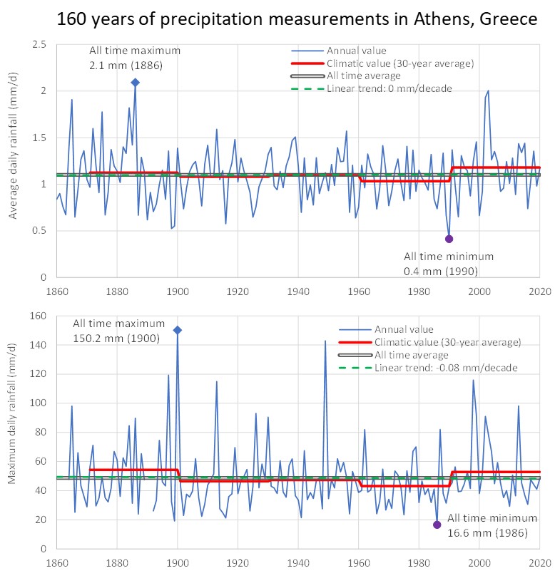
Full text: http://www.itia.ntua.gr/en/getfile/2287/1/documents/water-15-01711-v2.pdf (7639 KB)
Additional material:
- http://www.itia.ntua.gr/en/getfile/2287/3/documents/GraphicalAbstract404.jpg: Graphical abstract (131 KB)
-
D. Markantonis, G.-F. Sargentis, P. Dimitriadis, T. Iliopoulou, A. Siganou, K. Moraiti, M. Nikolinakou, I. Meletopoulos, N. Mamassis, and D. Koutsoyiannis, Stochastic Evaluation of the Investment Risk by the Scale of Water Infrastructures-Case Study: The Municipality of West Mani (Greece), World, 4 (1), 1–20, doi:10.3390/world4010001, 2022.
Social structure is based on the availability of the Water-Energy-Food Nexus. To cover these needs of society, several solutions of different scales of infrastructures coexist. The construction of infrastructure is capital-intensive; therefore, investment risk is always a consideration. In this paper, we try to evaluate the investment risk by interest rates (IR). We show that IR is a key indicator, which includes multiple parameters of prosperity expressing the political and economic status quo of the society. The selection of a particular scale influences the required capital and is thus one of the most critical decisions. Water supply infrastructure is one of the foundations of society, and the selection of the optimal scale of such infrastructure is often a great challenge in civil engineering. As a case study, we analyse three different scales of water supply infrastructures for the area of West Mani (Greece), i.e., dam, water ponds, and seawater desalination. We evaluate each case by the capital intensity by performing stochastic simulations of interest rates and identify the optimal solution as the one with the smallest median unit cost, in this case, the water ponds. In order to assess the impact of the development level of a country on the resulting unit cost stochastic properties we apply the optimal solution to various countries with different development levels and IR. We show that IR in the least developed countries, being generally higher and more variable, increases the unit cost, including its variability, which ultimately indicates higher investment risk.
Full text: http://www.itia.ntua.gr/en/getfile/2265/1/documents/world-04-00001-v2.pdf (4536 KB)
-
T. Iliopoulou, P. Dimitriadis, A. Siganou, D. Markantonis, K. Moraiti, M. Nikolinakou, I. Meletopoulos, N. Mamassis, D. Koutsoyiannis, and G.-F. Sargentis, Modern use of traditional rainwater harvesting practices: An assessment of cisterns’ water supply potential in West Mani, Greece, Heritage, 5 (4), 2944–2954, doi:10.3390/heritage5040152, 2022.
Water has always been a driver of human civilization. The first human civilizations thrived in places with an abundance of water, typically nearby large rivers as the Tigris–Euphrates, Yang Che and Nile. The invention and construction of hydraulic infrastructure came only later, in prehistoric times, triggered by the expansion of humanity in water-scarce areas. The ancient Greeks invented impressive hydraulic works and small-scale structures, some of which, such as cisterns, were still fully operational until the 20th century. We present a model that explains the use of cisterns in the water-scarce area of West Mani, which allows us to assess the potential of this traditional rainfall harvesting practice to support the modern water supply needs. To assess the system’s reliability, we employ a long-term simulation of a typical cistern system, using synthetic rainfall series from a stochastic model, and assuming variable water demand on a monthly scale. We show that a proper restoration of the cisterns could be sustainable as a complementary water supply source, decreasing the area’s drinking water cost and increasing the locals’ resilience against water shortages. In addition, we highlight the links between the area’s hydroclimate and its history and discuss the cultural merits of reviving and preserving this ancient, long practice.
Full text: http://www.itia.ntua.gr/en/getfile/2243/1/documents/heritage-05-00152-v3.pdf (4196 KB)
-
A. Koskinas, E. Zacharopoulou, G. Pouliasis, I. Deligiannis, P. Dimitriadis, T. Iliopoulou, N. Mamassis, and D. Koutsoyiannis, Estimating the Statistical Significance of Cross–Correlations between Hydroclimatic Processes in the Presence of Long–Range Dependence, Earth, 3 (3), 1027-1041, doi:10.3390/earth3030059, 2022.
Hydroclimatic processes such as precipitation, temperature, wind speed and dew point are usually considered to be independent of each other. In this study, the cross–correlations between key hydrological-cycle processes are examined, initially by conducting statistical tests, then adding the impact of long-range dependence, which is shown to govern all these processes. Subsequently, an innovative stochastic test that can validate the significance of the cross–correlation among these processes is introduced based on Monte-Carlo simulations. The test works as follows: observations obtained from numerous global-scale timeseries were used for application to, and a comparison of, the traditional methods of validation of statistical significance, such as the t-test, after filtering the data based on length and quality, and then by estimating the cross–correlations on an annual-scale. The proposed method has two main benefits: it negates the need of the pre-whitening data series which could disrupt the stochastic properties of hydroclimatic processes, and indicates tighter limits for upper and lower boundaries of statistical significance when analyzing cross–correlations of processes that exhibit long-range dependence, compared to classical statistical tests. The results of this analysis highlight the need to acquire cross–correlations between processes, which may be significant in the case of long-range dependence behavior.
Full text: http://www.itia.ntua.gr/en/getfile/2234/1/documents/earth-03-00059-v3.pdf (5430 KB)
-
N. Mamassis, S. Chrisoulaki, Aim. Bedenmaxer-Gerousis, T. Evangelou , P. Koutis, G. Peppas, P. Defteraios, N. Zarkadoulas, D. Koutsoyiannis, and E. Griva, Representing the operation and evolution of ancient Piraeus’ water supply system, Water History, doi:10.1007/s12685-022-00299-7, May 2022.
The newly excavated urban water supply system of the city of ancient Piraeus provides an excellent opportunity for the study and evaluation of the issues of sustainability, adaptability, simplicity and environmental protection, which are of main concern in modern engineering design practices. Well-digging in the area of Pireaus dates back to the city’ founding during the Classical period. However, scarcity of groundwaters stimulated development of water harvesting techniques, mainly cisterns for the collection of rain water, and to the gradual increase of their capacity in order to avoid overflows. Changes to land plot areas and the increase in water demand during the Hellenistic period affected the operation of cisterns triggering a variety of subterranean constructions that expanded the existing capacity. During the Roman period, the city’s water needs for domestic and public use skyrocketed beyond the supply capacity of the water resources of the Piraeus’ peninsula. On account of this, an aqueduct which transferred water from outside the peninsula was constructed in the 2nd century AD, while cisterns and wells were gradually abandoned. The present paper examines the operation of ancient Piraeus’ urban water supply system and its evolution across nine centuries by studying the operation and evolution of cisterns through a combination of excavation finds (from the Ephorate of Antiquities of Piraeus and the Islands) and quantitative techniques. Water consumption during several historical periods and the available water resources of the peninsula were quantified and a hydrologic model was developed to simulate the daily operation of the cisterns over an 82-year period. Various circumstances were examined by running numerous scenarios for the: (a) magnitude of collecting area, (b) annual water demand, and (c) capacity of the cisterns. For each scenario, the reliability of the hydro-system for supplying residences with water was estimated. Simulation results were then correlated with specific socio-economic characteristics of the corresponding historical periods.
Additional material:
- http://www.itia.ntua.gr/en/getfile/2191/2/documents/PeiraiasPreprint.pdf: preprint (4681 KB)
-
R. Ioannidis, N. Mamassis, A. Efstratiadis, and D. Koutsoyiannis, Reversing visibility analysis: Towards an accelerated a priori assessment of landscape impacts of renewable energy projects, Renewable and Sustainable Energy Reviews, 161, 112389, doi:10.1016/j.rser.2022.112389, 2022.
Impacts to landscapes have been identified as major drivers of social opposition against renewable energy projects. We investigate how the process of mitigating landscape impacts can be improved and accelerated, through a re-conceptualization of visibility analysis. In their conventional format, visibility analyses cannot be implemented in early planning phases as they require the finalized locations of projects as input. Thus, visual impacts to landscapes cannot be assessed until late in development, when licensing procedures have already begun and projects' locations have already been finalized. In order to overcome this issue and facilitate the earlier identification of impactful projects we investigate the reversal of visibility analyses. By shifting the focus of the analyses from the infrastructure that generates visual impacts to the areas that have to be protected from these impacts, visibility analyses no longer require projects' locations as input. This methodological shift is initially investigated theoretically and then practically, in the region of Thessaly, Greece, computing Reverse - Zones of Theoretical Visibility (R-ZTVs) for important landscape elements of the region, in order to then project visual impacts to them by planned wind energy projects. It was demonstrated that reversing visibility analyses (a) enables the creation of R-ZTV-type maps that facilitate the anticipation of landscape impacts of projects from earlier planning stages and (b) discards the requirement for individual visibility analyses for each new project, thus accelerating project development. Furthermore, R-ZTV maps can be utilized in participatory planning processes or be used independently by projects' investors and by stakeholders in landscape protection.
Additional material:
- http://www.itia.ntua.gr/en/getfile/2182/2/documents/IoannidisEtal.2022_pp.pdf: Preprint (3570 KB)
Other works that reference this work (this list might be obsolete):
1. Duarte, R., Á. García-Riazuelo, L. A. Sáez, and C. Sarasa, Analysing citizens’ perceptions of renewable energies in rural areas: A case study on wind farms in Spain, Energy Reports, 8, 12822-12831, doi:10.1016/j.egyr.2022.09.173, 2022. 2. Ko, I., Rural opposition to landscape change from solar energy: Explaining the diffusion of setback restrictions on solar farms across South Korean counties, Energy Research & Social Science, 99, 103073, doi:10.1016/j.erss.2023.103073, 2023. 3. Mikita, T., L. Janošíková, J. Caha, and E. Avoiani, The potential of UAV data as refinement of outdated inputs for visibility analyses, Remote Sensing, 15(4), 1028, doi:10.3390/rs15041028, 2023. 4. Rodríguez-Segura, F. J., and M. Frolova, How does society assess the impact of renewable energy in rural inland areas? Comparative analysis between the province of Jaén (Spain) and Somogy county (Hungary), Investigaciones Geográficas, 80, 193-214, doi:10.14198/INGEO.24444, 2023. 5. Beer, M., R. Rybár, and L. Gabániová, Visual impact of renewable energy infrastructure: implications for deployment and public perception, Processes, 11(8), 2252, doi:10.3390/pr11082252, 2023. 6. García-Ayllón, S., and G. Martínez, Analysis of correlation between anthropization phenomena and landscape values of the territory: A GIS framework based on spatial statistics, ISPRS International Journal of Geo-Information, 12(8), 323, doi:10.3390/ijgi12080323, 2023. 7. Sas-Bojarska, A., I. Orzechowska-Szajda, K. Puzdrakiewicz, and M. Kiejzik-Głowińska, Landscape, EIA and decision-making. A case study of the Vistula Spit Canal, Poland, Impact Assessment and Project Appraisal, 42(1), 2-29, doi:10.1080/14615517.2023.2273612, 2024. 8. Alphan, H., Incorporating visibility information into multi-criteria decision making (MCDM) for wind turbine deployment, Applied Energy, 353(B), 122164, doi:10.1016/j.apenergy.2023.122164, 2024. 9. Song, R., X. Gao, H. Nan, S. Zeng, and V. W. Y. Tam, Ecological restoration for mega-infrastructure projects: a study based on multi-source heterogeneous data, Engineering, Construction and Architectural Management, doi:10.1108/ECAM-12-2022-1197, 2023. 10. Abdul, D., J. Wenqi, A. Tanveer, and M. Sameeroddin, Comprehensive analysis of renewable energy technologies adoption in remote areas using the integrated Delphi-Fuzzy AHP-VIKOR approach, Arabian Journal for Science and Engineering, 49, 7585-7610, doi:10.1007/s13369-023-08334-2, 2024. 11. Codemo, A., M. Ghislanzoni, M.-J. Prados, and R. Albatici, Landscape-based spatial energy planning: minimization of renewables footprint in the energy transition, Journal of Environmental Planning and Management, doi:10.1080/09640568.2023.2287978, 2024. 12. Xiao, T. J. Deng, C. Wen, and Q. Gu, Parallel algorithm for multi-viewpoint viewshed analysis on the GPU grounded in target cluster segmentation, International Journal of Digital Earth, 17(1), doi:10.1080/17538947.2024.2308707, 2024. 13. Ji, G., and H. Sun, Assessing urban river landscape visual quality with extreme learning machines: A case study of the yellow river in Ningxia Hui autonomous region, China, Ecological Indicators, 165, 112173, doi:10.1016/j.ecolind.2024.112173, 2024. 14. Rosley, M. S. F., N. Z. Harun, J. N. Yusof, and S. R. Abdul Rahman, Empowering public participation in assessing the indicators of aesthetic value for historical landscape: a case study on Melaka, Malaysia, Cogent Arts & Humanities, 11(1), doi:10.1080/23311983.2024.2380114, 2024. 15. Tsani, T., J. M. Weinand, J. Linßen, and D. Stolten, Quantifying social factors for onshore wind planning – A systematic review, Renewable and Sustainable Energy Reviews, 203, 114762, doi:10.1016/j.rser.2024.114762, 2024. 16. Karasmanaki, E., S. Galatsidas, and G. Tsantopoulos, Exploring the nuances in citizen willingness-to-invest in renewable energy, Energy Efficiency, 17, 69, doi:10.1007/s12053-024-10250-9, 2024. 17. Wolsink, M., Land use as a crucial resource for smart grids — The ‘common good’ of renewables in distributed energy systems, Land, 13(8), 1236, doi:10.3390/land13081236, 2024. 18. Jiang, F., C. Wang, Y. Shi, and X. Zhang, Exploration of research hotspots and trends in photovoltaic landscape studies based on citespace analysis, Sustainability, 16(24), 11247, doi:10.3390/su162411247, 2024. 19. Krasniqi, I., Evaluating strategic approaches to energy transition: leadership, policy, and innovation in European countries, Economics and Environment, 90(3), 929, doi:10.34659/eis.2024.90.3.929, 2024. 20. Gleason, M., A. Lopez, and M. Rivers, Mapping and characterizing the visual impacts of the existing US wind turbine fleet, Applied Energy, 378(A), 124801, doi:10.1016/j.apenergy.2024.124801, 2025. 21. Ko, I., Who supports climate mitigation through increasing renewable energy surcharge? Evidence from an online survey in South Korea, Journal of Environmental Planning and Management, doi:10.1080/09640568.2024.2439875, 2025. 22. Peng, Y., S. Nijhuis, M. Geng, and Y. Yu, Enhancing visual attribute comprehension of urban heritage landscapes using combined GIS-based visual analysis methods: West Lake as a case study, Environmental Impact Assessment Review, 115, 108032, doi:10.1016/j.eiar.2025.108032, 2025. 23. Ko, I., N. Wittstock, and D. Frost, Rural–urban divide in support for renewable energy policy: evidence from Nevada’s renewable portfolio standard ballot initiative in 2020, Environmental Politics, doi:10.1080/09644016.2025.2543109, 2025. 24. Mamat, R., Erdiwansyah, M. F. Ghazali, S.M. Rosdi, Syafrizal, and Bahagia, Strategic framework for overcoming barriers in renewable energy transition: A multi-dimensional review, Next Energy, 9, 100414, doi:10.1016/j.nxener.2025.100414, 2025. 25. Mongird, K., C. Bracken, C. D. Burleyson, K. Oikonomou, Y. Ou, J. S. Rice, T. Thurber, and N. Voisin, More land is needed for solar and wind infrastructure under a high renewables scenario in the Western US by 2050, Communications Earth & Environment, 6, 765 doi:10.1038/s43247-025-02632-3, 2025. 26. Dimitrakopoulou, E., E. A. Diamantouli, M. Themou, A. Petras, T. Marou, Y. Noukakis, S. Vyzoviti, L. Kissas, S. Papamargariti, R. Ioannidis, P. Papailias, and A. Kouzoupi, Inclusive Mediterranean torrent cityscapes? A case study of design for just resilience against droughts and floods in Volos, Greece, Architecture, 5(4), 124, doi:10.3390/architecture5040124, 2025. 27. Yazdanmehr, S., A. Danesh, and P. Kumble, Variability in human preference for wind turbines: landscape characteristics, turbine distribution, and sociodemographic factors, Landscape and Ecological Engineering, 22, 105-126, doi:10.1007/s11355-025-00695-0, 2026. 28. Benito Muñoz, I., C. Zornoza Gallego, and J. Bañuls García, Hacia una planificación sectorial sobre las energías renovables: análisis territorial y propuesta metodológica para la implantación de la energía fotovoltaica en la provincia de Alicante, Investigaciones Geográficas, 85, 117–139, doi:10.14198/INGEO.29815, 2026. 29. Wang, L., H. Zhang, H. Wang, M. Rashed, T. G. Kvinen, and J. T. Karlsen, Towards a multi-layer project resilience framework: a hybrid approach from the dynamic capability perspective, International Journal of Managing Projects in Business, doi:10.1108/IJMPB-09-2025-0376, 2026. 30. Katikas, L., and V. Vassilopoulou, Reverse visual impact assessment (R-VIA) for offshore wind projects: An integrated spatial method for anticipatory, holistic and socially accepted planning, Environmental Impact Assessment Review, 120, 108453, doi:10.1016/j.eiar.2026.108453, 2026. 31. Chen, R., R. Li, and Y. Guo, Modeling and mining for multiscale visibility data of landscapes, npj Heritage Science, doi:10.1038/s40494-026-02554-z, 2026. 32. Esteva-Burgos, C., and M. Ruiz-Pérez, Measuring sea visibility: a condition for Ocean Literacy or a sign of privilege?, Frontiers in Marine Science, 13, 1836405, doi:10.3389/fmars.2026.1836405, 2026.
-
N. Mamassis, K. Mazi, E. Dimitriou, D. Kalogeras, N. Malamos, S. Lykoudis, A. Koukouvinos, I. L. Tsirogiannis, I. Papageorgaki, A. Papadopoulos, Y. Panagopoulos, D. Koutsoyiannis, A. Christofides, A. Efstratiadis, G. Vitantzakis, N. Kappos, D. Katsanos, B. Psiloglou, E. Rozos, T. Kopania, I. Koletsis, and A. D. Koussis, OpenHi.net: A synergistically built, national-scale infrastructure for monitoring the surface waters of Greece, Water, 13 (19), 2779, doi:10.3390/w13192779, 2021.
The large-scale surface-water monitoring infrastructure for Greece Open Hydrosystem Information Network (Openhi.net) is presented in this paper. Openhi.net provides free access to water data, incorporating existing networks that manage their own databases. In its pilot phase, Openhi.net operates three telemetric networks for monitoring the quantity and the quality of surface waters, as well as meteorological and soil variables. Aspiring members must also offer their data for public access. A web-platform was developed for on-line visualization, processing and managing telemetric data. A notification system was also designed and implemented for inspecting the current values of variables. The platform is built upon the web 2.0 technology that exploits the ever-increasing capabilities of browsers to handle dynamic data as a time series. A GIS component offers web-services relevant to geo-information for water bodies. Accessing, querying and downloading geographical data for watercourses (segment length, slope, name, stream order) and for water basins (area, mean elevation, mean slope, basin order, slope, mean CN-curve number) are provided by Web Map Services and Web Feature Services. A new method for estimating the streamflow from measurements of the surface velocity has been advanced as well to reduce hardware expenditures, a low-cost ‘prototype’ hydro-telemetry system (at about half the cost of a comparable commercial system) was designed, constructed and installed at six monitoring stations of Openhi.net.
Full text: http://www.itia.ntua.gr/en/getfile/2147/1/documents/water-13-02779-v2.pdf (3567 KB)
See also: https://www.mdpi.com/2073-4441/13/19/2779
Other works that reference this work (this list might be obsolete):
1. Spyrou, C., M. Loupis, N. Charizopoulos, P. Arvanitis, A. Mentzafou, E. Dimitriou, S. E. Debele, J. Sahani, and P. Kumar, Evaluating nature-based solution for flood reduction in Spercheios river basin Part 2: Early experimental evidence, Sustainability, 14(6), 10345, doi:10.3390/su141610345, 2022. 2. #Chrysanthopoulos, E., C. Pouliaris, I. Tsiroggianis, K. Markantonis, P. Kofakis, and A. Kallioras, Evaluating the efficiency of numerical and data driven modeling in forecasting soil water content, Proceedings of the 3rd IAHR Young Professionals Congress, 64-65, 2022. 3. #Samih, I., and D. Loudyi, Short-term urban water demand forecasting using Theta Models in Casablanca city, Morocco, Proceedings of the 3rd IAHR Young Professionals Congress, International Association for Hydro-Environment Engineering and Research, 2022. 4. Mazi, K., A. D. Koussis, S. Lykoudis, B. E. Psiloglou, G. Vitantzakis, N. Kappos, D. Katsanos, E. Rozos, I. Koletsis, and T. Kopania, Establishing and operating (pilot phase) a telemetric streamflow monitoring network in Greece, Hydrology, 10(1), 19, doi:10.3390/hydrology10010019, 2023. 5. Koltsida, E., N. Mamassis, and A. Kallioras, Hydrological modeling using the Soil and Water Assessment Tool in urban and peri-urban environments: the case of Kifisos experimental subbasin (Athens, Greece), Hydrology and Earth System Sciences, 27, 917-931, doi:10.5194/hess-27-917-2023, 2023. 6. Tsirogiannis, I. L., N. Malamos, and P. Baltzoi, Application of a generic participatory decision support system for irrigation management for the case of a wine grapevine at Epirus, Northwest Greece, Horticulturae, 9(2), 267, doi:10.3390/horticulturae9020267, 2023. 7. Yeşilköy, S., Ö. Baydaroğlu, N. Singh, Y. Sermet, and I. Demir, A contemporary systematic review of cyberinfrastructure systems and applications for flood and drought data analytics and communication, EarthArXiv, doi:10.31223/X5937W, 2023. 8. Fotia, K., and I. Tsirogiannis, Water footprint score: A practical method for wider communication and assessment of water footprint performance, Environmental Sciences Proceedings, 25(1), 71, doi:10.3390/ECWS-7-14311, 2023. 9. Bloutsos, A. A., V. I. Syngouna, I. D. Manariotis, and P. C. Yannopoulos, Seasonal and long-term water quality of Alfeios River Basin in Greece, Water, Air and Soil Pollution, 235, 215, doi:10.1007/s11270-024-06981-1, 2024. 10. Kalantzopoulos, G., P. Paraskevopoulos, G. Domalis, A. Liopa-Tsakalidi, D. E. Tsesmelis, and P. E. Barouchas, The Western Greece Soil Information System (WΕSIS)—A soil health design supported by the internet of things, soil databases, and artificial intelligence technologies in Western Greece, Sustainability, 16(8), 3478, doi:10.3390/su16083478, 2024. 11. Pappa, D., A. Kallioras, and D. Kaliampakos, Water mismanagement in agriculture: a case study of Greece. Starting with “how” and "why", Al-Qadisiyah Journal For Agriculture Sciences, 14(1), 90-106, doi:10.33794/qjas.2024.149833.1175, 2024. 12. #Chrysanthopoulos, E., C. Pouliaris, I. Tsirogiannis, P. Kofakis, and A. Kallioras, Development of soil moisture model based on deep learning, In: Ksibi, M., et al. Recent Advances in Environmental Science from the Euro-Mediterranean and Surrounding Regions (4th Edition), EMCEI 2022. Advances in Science, Technology & Innovation. Springer, Cham, doi:10.1007/978-3-031-51904-8_105, 2024. 13. Chrysanthopoulos, E., and A. Kallioras, Temporal and geographic extrapolation of soil moisture using machine learning algorithms, Catena, 257, 109156, doi:10.1016/j.catena.2025.109156, 2025. 14. Zotou, I., V. Bellos, and V. A. Tsihrintzis, Calibration framework for complex 2D hydrodynamic models: Use of satellite-derived flood extent and water depth data, and evaluation with various performance metrics, Advances in Water Resources, 204, 105066, doi:10.1016/j.advwatres.2025.105066, 2025. 15. Chrysanthopoulos, E., and A. Kallioras, A framework for monitoring soil hydraulic properties of undisturbed soil samples and modeling unsaturated zone water flow, Environmental Processes, 12, 47, doi:10.1007/s40710-025-00791-1, 2025. 16. Pappa, D., A. Kallioras, and D. Kaliampakos, Water availability without reliability: Groundwater-dependent irrigation and governance challenges in the Arta plain, Greece, Water, 18(5), 623, doi:10.3390/w18050623, 2026. 17. Tsimnadis, K., K. Merakos Vanias, E. Kallikantzarou, C. Karavitis, and P. Trivellas, Geomorphological change and water quality demonstrating environmental resilience in Mediterranean watersheds amidst climatic and socio-economic transformations: Evidence from Greece, Earth, 7(2), 64, doi:10.3390/earth7020064, 2026. 18. Mazi, K., E. Akylas, and A. D. Koussis, Estimation of the mean-to-surface-velocity ratio in shallow streams with rough beds, Water, 18(8), 985, doi:10.3390/w18080985, 2026. 19. Koulouris, D., and N. Malamos, Bayesian additive regression trees for multi-depth soil moisture modeling, Agriculture, 16(10), 1120, doi:10.3390/agriculture16101120, 2026.
-
G.-F. Sargentis, T. Iliopoulou, P. Dimitriadis, N. Mamassis, and D. Koutsoyiannis, Stratification: An entropic view of society's structure, World, 2, 153–174, doi:10.3390/world2020011, 2021.
In human societies, we observe a wide range of types of stratification, i.e., in terms of financial class, political power, level of education, sanctity, and military force. In financial, political, and social sciences, stratification is one of the most important issues and tools as the Lorenz Curve and the Gini Coefficient have been developed to describe some of its aspects. Stratification is greatly dependent on the access of people to wealth. By “wealth”, we mean the quantified prosperity which increases the life expectancy of people. Prosperity is also connected to the water‐food‐energy nexus which is necessary for human survival. Analyzing proxies of the water‐food‐energy nexus, we suggest that the best proxy for prosperity is energy, which is closely related to Gross Domestic Product (GDP) per capita and life expectancy. In order to describe the dynamics of social stratification, we formulate an entropic view of wealth in human societies. An entropic approach to income distribution, approximated as available energy in prehistoric societies, till present‐day economies, shows that stratification can be viewed as a stochastic process subject to the principle of maximum entropy and occurring when limits to the wealth of society are set, either by the political and economic system and/or by the limits of available technology.
Full text: http://www.itia.ntua.gr/en/getfile/2107/1/documents/world-02-00011-v3.pdf (10384 KB)
Works that cite this document: View on Google Scholar or ResearchGate
-
D. Koutsoyiannis, and N. Mamassis, From mythology to science: the development of scientific hydrological concepts in the Greek antiquity and its relevance to modern hydrology, Hydrology and Earth System Sciences, 25, 2419–2444, doi:10.5194/hess-25-2419-2021, 2021.
Whilst hydrology is a Greek term, it has not been in use in the Classical literature but much later, during the Renaissance, in its Latin version, hydrologia. On the other hand, Greek natural philosophers created robust knowledge in related scientific areas, to which they gave names such as meteorology, climate and hydraulics. These terms are now in common use internationally. Within these areas, Greek natural philosophers laid the foundation of hydrological concepts and the hydrological cycle in its entirety. Knowledge development was brought about by search for technological solutions to practical problems, as well as by scientific curiosity to explain natural phenomena. While initial explanations belong to the sphere of mythology, the rise of philosophy was accompanied by attempts to provide scientific descriptions of the phenomena. It appears that the first geophysical problem formulated in scientific terms was the explanation of the flood regime of the Nile, then regarded as a paradox because of the spectacular difference from the river flow regime in Greece and other Mediterranean regions, i.e., the fact that the Nile flooding occurs in summer when in most of the Mediterranean the rainfall is very low. While some of the early attempts to explain it were influenced by Homer’s mythical view (archaic period), eventually, Aristotle was able to formulate a correct hypothesis, which he tested through what it appears to be the first in history scientific expedition, in the turn from the Classical to Hellenistic period. This confirms the fact that the hydrological cycle was well understood during the Classical period yet it poses the question why Aristotle’s correct explanation had not been accepted and, instead, ancient and modern mythical views had been preferred up to the 18th century.
Full text: http://www.itia.ntua.gr/en/getfile/2087/1/documents/hess-25-2419-2021.pdf (30835 KB)
Additional material:
- http://www.itia.ntua.gr/en/getfile/2087/2/documents/hess-25-2419-2021-supplement.pdf: Supplement (2642 KB)
- http://www.itia.ntua.gr/en/getfile/2087/20/documents/hess-2021-7-manuscript-version1_DK.pdf: Preprint, Version 1 (4754 KB)
- http://www.itia.ntua.gr/en/getfile/2087/30/documents/FromMythologyToScience_v2.pdf: Preprint, Version 2 (2407 KB)
-
R. Ioannidis, T. Iliopoulou, C. Iliopoulou, L. Katikas, A. Petsou, M.-E. Merakou, M.-E. Asimomiti, N. Pelekanos, G. Koudouris, P. Dimitriadis, C. Plati, E. Vlahogianni, K. Kepaptsoglou, N. Mamassis, and D. Koutsoyiannis, Solar-powered bus route: introducing renewable energy into a university campus transport system, Advances in Geosciences, 49, doi:10.5194/adgeo-49-215-2019, 2019.
We investigate the application of a solar-powered bus route to a small-scale transportation system, as such of a university campus. In particular, we explore the prospect of replacing conventional fossil fuel buses by electric buses powered by solar energy and electricity provided by the central grid. To this end, we employ GIS mapping technology to estimate the solar radiation at the university campus and, accordingly, we investigate three different scenarios for harnessing the available solar power: (1) solar panels installed on the roof of bus stop shelters, (2) solar panels installed at an unused open space in the university, and (3) solar roads, i.e. roads constructed by photovoltaic (PV) materials. For each of the three scenarios, we investigate the optimal technical configuration, the resulting energy generation, as well as the capital cost for application in the case of NTUA campus in Athens (Greece). The preliminary feasibility analysis showcases that all three scenarios contribute to satisfying transportation demand, proportionately to their size, with scenario (2) presenting the lowest capital cost in relation to energy generation. Therefore, we further explore this scenario by simulating its daily operation including the actions of buying and selling energy to the central grid, when there is energy deficit or surplus, respectively. A sensitivity analysis is carried out in order to ascertain the optimal size of the solar panel installation in relation to profit and reliability. Overall, results indicate that, albeit the high capital costs, solar-powered transportation schemes present a viable alternative for replacing conventional buses at the studied location, especially considering conventional PV panels. We note that present results heavily depend on the choice of capacity factors of PV materials, which differ among technologies. Yet, as capacity factors of PV panels are currently increasing, the studied schemes might be more promising in the future.
Full text: http://www.itia.ntua.gr/en/getfile/2016/1/documents/adgeo-49-215-2019.pdf (8167 KB)
Works that cite this document: View on Google Scholar or ResearchGate
-
G. Papacharalampous, H. Tyralis, A. Langousis, A. W. Jayawardena, B. Sivakumar, N. Mamassis, A. Montanari, and D. Koutsoyiannis, Probabilistic hydrological post-processing at scale: Why and how to apply machine-learning quantile regression algorithms, Water, doi:10.3390/w11102126, 2019.
We conduct a large-scale benchmark experiment aiming to advance the use of machine-learning quantile regression algorithms for probabilistic hydrological post-processing “at scale” within operational contexts. The experiment is set up using 34-year-long daily time series of precipitation, temperature, evapotranspiration and streamflow for 511 catchments over the contiguous United States. Point hydrological predictions are obtained using the Génie Rural à 4 paramètres Journalier (GR4J) hydrological model and exploited as predictor variables within quantile regression settings. Six machine-learning quantile regression algorithms and their equal-weight combiner are applied to predict conditional quantiles of the hydrological model errors. The individual algorithms are quantile regression, generalized random forests for quantile regression, generalized random forests for quantile regression emulating quantile regression forests, gradient boosting machine, model-based boosting with linear models as base learners and quantile regression neural networks. The conditional quantiles of the hydrological model errors are transformed to conditional quantiles of daily streamflow, which are finally assessed using proper performance scores and benchmarking. The assessment concerns various levels of predictive quantiles and central prediction intervals, while it is made both independently of the flow magnitude and conditional upon this magnitude. Key aspects of the developed methodological framework are highlighted, and practical recommendations are formulated. In technical hydro-meteorological applications, the algorithms should be applied preferably in a way that maximizes the benefits and reduces the risks from their use. This can be achieved by (i) combining algorithms (e.g., by averaging their predictions) and (ii) integrating algorithms within systematic frameworks (i.e., by using the algorithms according to their identified skills), as our large-scale results point out.
Full text: http://www.itia.ntua.gr/en/getfile/2001/1/documents/water-11-02126.pdf (6451 KB)
Works that cite this document: View on Google Scholar or ResearchGate
-
G. Koudouris, P. Dimitriadis, T. Iliopoulou, N. Mamassis, and D. Koutsoyiannis, A stochastic model for the hourly solar radiation process for application in renewable resources management, Advances in Geosciences, 45, 139–145, doi:10.5194/adgeo-45-139-2018, 2018.
Since the beginning of the 21st century, the scientific community has made huge leaps to exploit renewable energy sources, with solar radiation being one of the most important. However, the variability of solar radiation has a significant impact on solar energy conversion systems, such as in photovoltaic systems, characterized by a fast and nonlinear response to incident solar radiation. The performance prediction of these systems is typically based on hourly or daily data because those are usually available at these time scales. The aim of this work is to investigate the stochastic nature and time evolution of the solar radiation process for daily and hourly scale, with the ultimate goal of creating a new cyclostationary stochastic model capable of reproducing the dependence structure and the marginal distribution of hourly solar radiation via the clearness index KT .
Full text: http://www.itia.ntua.gr/en/getfile/1867/1/documents/adgeo-45-139-2018.pdf (4911 KB)
Works that cite this document: View on Google Scholar or ResearchGate
-
E. Klousakou, M. Chalakatevaki, P. Dimitriadis, T. Iliopoulou, R. Ioannidis, G. Karakatsanis, A. Efstratiadis, N. Mamassis, R. Tomani, E. Chardavellas, and D. Koutsoyiannis, A preliminary stochastic analysis of the uncertainty of natural processes related to renewable energy resources, Advances in Geosciences, 45, 193–199, doi:10.5194/adgeo-45-193-2018, 2018.
The ever-increasing energy demand has led to overexploitation of fossil fuels deposits, while renewables offer a viable alternative. Since renewable energy resources derive from phenomena related to either atmospheric or geophysical processes, unpredictability is inherent to renewable energy systems. An innovative and simple stochastic tool, the climacogram, was chosen to explore the degree of unpredictability. By applying the climacogram across the related timeseries and spatial-series it was feasible to identify the degree of unpredictability in each process through the Hurst parameter, an index that quantifies the level of uncertainty. All examined processes display a Hurst parameter larger than 0.5, indicating increased uncertainty on the long term. This implies that only through stochastic analysis may renewable energy resources be reliably manageable and cost efficient. In this context, a pilot application of a hybrid renewable energy system in the Greek island of Astypalaia is discussed, for which we show how the uncertainty (in terms of variability) of the input hydrometeorological processes alters the uncertainty of the output energy values.
Full text: http://www.itia.ntua.gr/en/getfile/1864/1/documents/adgeo-45-193-2018.pdf (559 KB)
See also: https://www.adv-geosci.net/45/193/2018/
Works that cite this document: View on Google Scholar or ResearchGate
Other works that reference this work (this list might be obsolete):
1. Kaps, C., S. Marinesi, and S. Netessine, When should the off-grid sun shine at night? Optimum renewable generation and energy storage investment, Management Science, 69(12), 7633-7650, doi:10.1287/mnsc.2021.04129, 2023. 2. Adewumi, A., C. E. Okoli, F. O. Usman, K. A. Olu-lawal, and O. T. Soyombo, Reviewing the impact of AI on renewable energy efficiency and management, International Journal of Science and Research Archive, 11(01), 1518–1527, doi:10.30574/ijsra.2024.11.1.0245, 2024. 3. #Awudu, S., A. K. Yeliawati, and M. Sari, Unveiling the green tapestry: Exploring the influence of green budget tagging on the nexus of fiscal policy sustainability and green budgeting practices in metropolitan municipal and district assemblies in Ghana, Proceedings of the 8th Global Conference on Business, Management, and Entrepreneurship (GCBME 2023), 186-192, Atlantic Press, 2024. 4. Mosiño, A., and A. Pommeret, Switching to clean(er) technologies in a stochastic environment, Energies, 19(3), 861, doi:10.3390/en19030861, 2026.
-
H. Tyralis, G. Karakatsanis, K. Tzouka, and N. Mamassis, Data and code for the exploratory data analysis of the electrical energy demand in the time domain in Greece, Data in Brief, 13 (700-702), doi:http://dx.doi.org/10.1016/j.energy.2017.06.074, 2017.
We present data and code for visualizing the electrical energy data and weather-,climate-related and socioeconomic variables in the time domain in Greece. The electrical energy data include hourly demand, weekly-ahead forecasted values of the demand provided by the Greek Independent Power Transmission Operator and pricing values in Greece. We also present the daily temperature in Athens and the Gross Domestic Product of Greece. The code combines the data to a single report, which includes all visualizations with combinations of all variables in multiple time scales. The data and code we reused in Tyralis et al.(2017)
Full text: http://www.itia.ntua.gr/en/getfile/1825/1/documents/DataAndCode.pdf (127 KB)
-
G. Koudouris, P. Dimitriadis, T. Iliopoulou, N. Mamassis, and D. Koutsoyiannis, Investigation on the stochastic nature of the solar radiation process, Energy Procedia, 125, 398–404, 2017.
A detailed investigation of the variability of solar radiation can be proven useful towards more efficient and sustainable design of renewable resources systems. In this context, we analyze observations from Athens, Greece and we investigate the marginal distribution of the solar radiation process at a daily and hourly step, the long-term behavior based on the annual scale of the process, as well as the double periodicity (diurnal-seasonal) of the process. Finally, we apply a parsimonious double-cyclostationary stochastic model to generate hourly synthetic time series preserving the marginal statistical characteristics, the double periodicity and the dependence structure of the process.
Full text: http://www.itia.ntua.gr/en/getfile/1736/1/documents/solar_procedia.pdf (804 KB)
Works that cite this document: View on Google Scholar or ResearchGate
-
M. Chalakatevaki, P. Stamou, S. Karali, V. Daniil, P. Dimitriadis, K. Tzouka, T. Iliopoulou, D. Koutsoyiannis, P. Papanicolaou, and N. Mamassis, Creating the electric energy mix in a non-connected island, Energy Procedia, 125, 425–434, doi:10.1016/j.egypro.2017.08.089, 2017.
As the electric energy in the non-connected islands is mainly produced by oil-fueled power plants, the unit cost is extremely high due to import cost. The integration of renewable resources in the energy mix is essential for reducing the financial and environmental cost. In this work, various energy resources (renewable and fossil fuels) are evaluated using technical, environmental and economic criteria with an emphasis to biomass, pumped hydro storage and replacement of oil power plants. Finally, a synthesis is presented as a toy-model in an Aegean island that satisfies the electric energy demand including base and peak electric loads.
Related works:
- [138] Initial presentation in EGU conference
Full text: http://www.itia.ntua.gr/en/getfile/1733/1/documents/electric_mix_energy_procedia.pdf (1118 KB)
Works that cite this document: View on Google Scholar or ResearchGate
Other works that reference this work (this list might be obsolete):
1. Bakanos, P. I., and K. L. Katsifarakis, Optimizing operation of a large-scale pumped storage hydropower system coordinated with wind farm by means of genetic algorithm, Global Nest Journal, 2019. 2. Giudici, F., A. Castelletti, E. Garofalo, M. Giuliani, and H. R. Maier, Dynamic, multi-objective optimal design and operation of water-energy systems for small, off-grid islands, Applied Energy, 250, 605-616, doi:10.1016/j.apenergy.2019.05.084, 2019.
-
H. Tyralis, G. Karakatsanis, K. Tzouka, and N. Mamassis, Exploratory data analysis of the electrical energy demand in the time domain in Greece, Energy, 134 (902-918), 16 pages, doi:10.1016/j.energy.2017.06.074 0360-5442, 2017.
The electrical energy demand (EED) in Greece for the time period 2002-2016 is investigated. The aim of the study is to introduce a framework for the exploratory data analysis (EDA) of the EED in the time domain. To this end, the EED at the hourly, daily, seasonal and annual time scale along with the mean daily temperature and the Gross Domestic Product (GDP) of Greece are visualized. The forecast of the EED provided by the Greek Independent Power Transmission Operator (IPTO) is also visualized and is compared with the actual EED. Furthermore, the EED pricing system is visualized. The results of the study in general confirm and summarize the conclusions of previous relevant studies in Greece, each one treating a single topic and covering shorter and earlier time periods. Furthermore, some unexpected patterns are observed, which if not considered carefully could result to dubious models. Therefore, it is shown that the EDA of the EED in the time domain coupled with weather-, climate-related and socio-economic variables is essential for the building of a model for the short-, medium- and long-term EED forecasting, something not highlighted in the literature.
Full text: http://www.itia.ntua.gr/en/getfile/1722/1/documents/EDA_electricity_2017.pdf (3406 KB)
-
H. Tyralis, A. Tegos, A. Delichatsiou, N. Mamassis, and D. Koutsoyiannis, A perpetually interrupted interbasin water transfer as a modern Greek drama: Assessing the Acheloos to Pinios interbasin water transfer in the context of integrated water resources management, Open Water Journal, 4 (1), 113–128, 12, 2017.
Interbasin water transfer is a primary instrument of water resources management directly related with the integrated development of the economy, society and environment. Here we assess the project of the interbasin water transfer from the river Acheloos to the river Pinios basin which has intrigued the Greek society, the politicians and scientists for decades. Te set of criteria we apply originate from a previous study reviewing four interbasin water transfers and assessing whether an interbasin water transfer is compatible with the concept of integrated water resources management. In this respect, we assess which of the principles of the integrated water resources management the Acheloos to Pinios interbasin water transfer project does or does not satisfy. While the project meets the criteria of real surplus and deficit, of sustainability and of sound science, i.e., the criteria mostly related to the engineering part, it fails to meet the criteria of good governance and balancing of existing rights with needs, i.e., the criteria associated with social aspects of the project. Te non-fulfillment of the latter criteria is the consequence of chronic diseases of the Greek society, which become obvious in the case study
Full text: http://www.itia.ntua.gr/en/getfile/1702/1/documents/2017OW_AcheloosToPiniosInterbasinWaterTransfer.pdf (2744 KB)
See also: http://scholarsarchive.byu.edu/openwater/vol4/iss1/11/
Works that cite this document: View on Google Scholar or ResearchGate
-
H. Tyralis, N. Mamassis, and Y. Photis, Spatial analysis of the electrical energy demand in Greece, Energy Policy, 102 (340-352), doi:10.1016/j.enpol.2016.12.033, March 2017.
The Electrical Energy Demand (EED) of the agricultural, commercial and industrial sector in Greece, as well as its use for domestic activities, public and municipal authorities and street lighting are analysed spatially using Geographical Information System and spatial statistical methods. The analysis is performed on data which span from 2008 to 2012 and have annual temporal resolution and spatial resolution down to the NUTS (Nomenclature of Territorial Units for Statistics) level 3. The aim is to identify spatial patterns of the EED and its transformations such as the ratios of the EED to socioeconomic variables, i.e. the population, the total area, the population density and the Gross Domestic Product (GDP). Based on the analysis, Greece is divided in five regions, each one with a different development model, i.e. Attica and Thessaloniki which are two heavily populated major poles, Thessaly and Central Greece which form a connected geographical region with important agricultural and industrial sector, the islands and some coastal areas which are characterized by an important commercial sector and the rest Greek areas. The spatial patterns can provide additional information for policy decision about the electrical energy management and better representation of the regional socioeconomic conditions.
Full text: http://www.itia.ntua.gr/en/getfile/1674/1/documents/electr_GIS_R_2016.pdf (2357 KB)
-
H. Tyralis, N. Mamassis, and Y. Photis, Spatial Analysis of Electrical Energy Demand Patterns in Greece: Application of a GIS-based Methodological Framework, Energy Procedia, 97 (262-269), 8 pages, doi:10.1016/j.egypro.2016.10.071, November 2016.
We investigate various uses of the Electrical Energy Demand (EED) in Greece (agricultural, commercial, domestic, industrial use) and we examine their relationships with variables such as population and the Gross Domestic Product. The analysis is performed on data from the year 2012 and have spatial resolution down to the level of prefecture. We both visualize the results of the analysis and we perform spatial cluster and outlier analysis. The definition of the spatial patterns of the aforementioned variables in a GIS environment provides insight of the regional development model in Greece.
Full text: http://www.itia.ntua.gr/en/getfile/1672/1/documents/SpatialAnalyis.pdf (1019 KB)
-
K. Kollyropoulos, F. Georma, F. Saranti, N. Mamassis, and I. Kalavrouziotis, Urban planning and water management in Ancient Aetolian Makyneia, Western Greece, Water Science and Technology: Water Supply, 16 (5), doi:DOI: 10.2166/ws.2016.145 , September 2016.
The findings of a large – scale archaeological investigation, conducted from 2009 to 2013 at a site in the vicinity of Antirrion – Western Greece, identified with ancient Makyneia, provides interesting information on the architectural features and urban planning of an ancient settlement in this area of mainland Western Greece. Through an interdisciplinary study of its morphological and technological characteristics water management problems and solutions can be revealed by the water management infrastructure (waterways, water reservoirs drainage systems etc.) as it has been documented during the excavation, An interesting question to investigate is whether water management systems of the ancient settlement represent sustainable techniques and principles that can still be used today. To this aim the functioning of systems is reconstructed and characteristic quantities are calculated both for the potable water system and the drainage system.
Full text: http://www.itia.ntua.gr/en/getfile/1669/1/documents/WS-EM16213R2.pdf (823 KB)
-
P. Dimitriadis, A. Tegos, A. Oikonomou, V. Pagana, A. Koukouvinos, N. Mamassis, D. Koutsoyiannis, and A. Efstratiadis, Comparative evaluation of 1D and quasi-2D hydraulic models based on benchmark and real-world applications for uncertainty assessment in flood mapping, Journal of Hydrology, 534, 478–492, doi:10.1016/j.jhydrol.2016.01.020, 2016.
One-dimensional and quasi-two-dimensional hydraulic freeware models (HEC-RAS, LISFLOOD-FP and FLO-2d) are widely used for flood inundation mapping. These models are tested on a benchmark test with a mixed rectangular-triangular channel cross section. Using a Monte-Carlo approach, we employ extended sensitivity analysis by simultaneously varying the input discharge, longitudinal and lateral gradients and roughness coefficients, as well as the grid cell size. Based on statistical analysis of three output variables of interest, i.e. water depths at the inflow and outflow locations and total flood volume, we investigate the uncertainty enclosed in different model configurations and flow conditions, without the influence of errors and other assumptions on topography, channel geometry and boundary conditions. Moreover, we estimate the uncertainty associated to each input variable and we compare it to the overall one. The outcomes of the benchmark analysis are further highlighted by applying the three models to real-world flood propagation problems, in the context of two challenging case studies in Greece.
Works that cite this document: View on Google Scholar or ResearchGate
Other works that reference this work (this list might be obsolete):
1. Apel, H., O. Martínez Trepat, N. N. Hung, D. T. Chinh, B. Merz, and N. V. Dung, Combined fluvial and pluvial urban flood hazard analysis: concept development and application to Can Tho city, Mekong Delta, Vietnam, Natural Hazards and Earth System Sciences, 16, 941-961, doi:10.5194/nhess-16-941-2016, 2016. 2. Papaioannou , G., A. Loukas, L. Vasiliades, and G. T. Aronica, Flood inundation mapping sensitivity to riverine spatial resolution and modelling approach, Natural Hazards, 83, 117-132, doi:10.1007/s11069-016-2382-1, 2016. 3. #Santillan, J. R., A. M. Amora, M. Makinano-Santillan, J. T. Marqueso, L. C. Cutamora, J. L. Serviano, and R. M. Makinano, Assessing the impacts of flooding caused by extreme rainfall events through a combined geospatial and numerical modeling approach, The International Archives of the Photogrammetry, Remote Sensing and Spatial Information Sciences, Vol. XLI-B8, 2016, XXIII ISPRS Congress, Prague, doi:10.5194/isprs-archives-XLI-B8-1271-2016, 2016. 4. Cheviron, B. and R. Moussa, Determinants of modelling choices for 1-D free-surface flow and morphodynamics in hydrology and hydraulics: a review, Hydrology and Earth System Sciences, 20, 3799-3830, doi:10.5194/hess-20-3799-2016, 2016. 5. Anees, M.T., K. Abdullah, M.N.M. Nawawi, N. N. N. Ab Rahman, A. R. Mt. Piah, N. A. Zakaria, M.I. Syakir, and A.K. Mohd. Omar, Numerical modeling techniques for flood analysis, Journal of African Earth Sciences, 124, 478–486, doi:10.1016/j.jafrearsci.2016.10.001, 2016. 6. Skublics, D., G. Blöschl, and P. Rutschmann, Effect of river training on flood retention of the Bavarian Danube, Journal of Hydrology and Hydromechanics, 64(4), 349-356, doi:10.1515/johh-2016-0035, 2016. 7. Doong, D.-J., W. Lo, Z. Vojinovic, W.-L. Lee, and S.-P. Lee, Development of a new generation of flood inundation maps—A case study of the coastal City of Tainan, Taiwan, Water, 8(11), 521, doi:10.3390/w8110521, 2016. 8. #Cartaya, S., and R. Mantuano-Eduarte, Identificación de zonas en riesgo de inundación mediante la simulación hidráulica en un segmento del Río Pescadillo, Manabí, Ecuador, Revista de Investigación, 40(89), 158-170, 2016. 9. Javadnejad, F., B. Waldron, and A. Hill, LITE Flood: Simple GIS-based mapping approach for real-time redelineation of multifrequency floods, Natural Hazards Review, 18(3), doi:10.1061/(ASCE)NH.1527-6996.0000238, 2017. 10. Shrestha, A., M. S. Babel, S. Weesakul, and Z. Vojinovic, Developing intensity–duration–frequency (IDF) curves under climate change uncertainty: The case of Bangkok, Thailand, Water, 9(2), 145, doi:10.3390/w9020145, 2017. 11. Roushangar, K., M. T. Alami, V. Nourani, and A. Nouri, A cost model with several hydraulic constraints for optimizing in practice a trapezoidal cross section, Journal of Hydroinformatics, 19(3), 456-468, doi:10.2166/hydro.2017.081, 2017. 12. Papaioannou, G., L. Vasiliades, A. Loukas, and G. T. Aronica, Probabilistic flood inundation mapping at ungauged streams due to roughness coefficient uncertainty in hydraulic modelling, Advances in Geosciences, 44, 23-34, doi:10.5194/adgeo-44-23-2017, 2017. 13. Anees, M. T., K. Abdullah, M. N. M. Nawawi, N. N. N. Ab Rahman, A. R. Mt. Piah, M. I. Syakir, A. K. M. Omar, and K. Hossain, Applications of remote sensing, hydrology and geophysics for flood analysis, Indian Journal of Science and Technology, 10(17), doi:10.17485/ijst/2017/v10i17/111541, 2017. 14. Fuentes-Andino, D., K. Beven, S. Halldin, C.-Y. Xu, J. E. Reynolds, and G. Di Baldassarre, Reproducing an extreme flood with uncertain post-event information, Hydrology and Earth System Sciences, 21, 3597-3618, doi:10.5194/hess-21-3597-2017, 2017. 15. #Anees, M. T., K. Abdullah, M. N. M. Nordin, N. N. N. Ab Rahman, M. I. Syakir, and M. O. A. Kadir, One- and two-dimensional hydrological modelling and their uncertainties, Flood Risk Management, T. Hromadka and P. Rao (editors), Chapter 11, doi:10.5772/intechopen.68924, 2017. 16. #Papaioannou, G., A. Loukas, L. Vasiliades, and G. T. Aronica, Sensitivity analysis of a probabilistic flood inundation mapping framework for ungauged catchments, Proceedings of the 10th World Congress of EWRA “Panta Rhei”, European Water Resources Association, Athens, 2017. 17. Bangira, T., S. M. Alfieri , M. Menenti, A. van Niekerk, and Z. Vekerdy, A spectral unmixing method with ensemble estimation of endmembers: Application to flood mapping in the Caprivi floodplain, Remote Sensing, 9, 1013, doi:10.3390/rs9101013, 2017. 18. Carisi, F., A. Domeneghetti, M. G. Gaeta, and A. Castellarin, Is anthropogenic land subsidence a possible driver of riverine flood-hazard dynamics? A case study in Ravenna, Italy, Hydrological Sciences Journal, 62(15), 2440-2455, doi:10.1080/02626667.2017.1390315, 2017. 19. Podhoranyi, M., P. Veteska, D. Szturcova, L. Vojacek, and A. Portero, A web-based modelling and monitoring system based on coupling environmental models and hydrological-related data, Journal of Communications, 12(6), 340-346, doi:10.12720/jcm.12.6.340-346, 2017. 20. Bhuyian, N. M., A. Kalyanapu, and F. Hossain, Evaluating conveyance-based DEM correction technique on NED and SRTM DEMs for flood impact assessment of the 2010 Cumberland river flood, Geosciences, 7(4), 132; doi:10.3390/geosciences7040132, 2017. 21. Zin, W., A. Kawasaki, W. Takeuchi, Z. M. L. T. San, K. Z. Htun, T. H. Aye, and S. Win, Flood hazard assessment of Bago river basin, Myanmar, Journal of Disaster Research, 13(1), 14-21, doi:10.20965/jdr.2018.p0014, 2018. 22. #Siregar, R. I., Hydraulic modeling of flow impact on bridge structures: a case study on Citarum bridge, IOP Conference Series: Materials Science and Engineering, 309, 012015, doi:10.1088/1757-899X/309/1/012015, 2018. 23. Miranda, D., R. F. Camacho, S. Lousada, and R. A. Castanho, Hydraulic studies and their influence for regional urban planning: a practical approach to Funchal’s rivers, Revista Brasiliera de Planejamento e Desenvolvimento, 7(1), 145-164, doi:10.3895/rbpd.v7n1.7179, 2018. 24. Liu, W., and H. Liu, Integrating Monte Carlo and the hydrodynamic model for predicting extreme water levels in river systems, Preprints 2018, 2018030088, doi:10.20944/preprints201803.0088.v1, 2018. 25. #Indrawan, I., and R. I. Siregar, Analysis of flood vulnerability in urban area: a case study in Deli watershed, Journal of Physics Conference Series, 978(1), 012036, doi:10.1088/1742-6596/978/1/012036, 2018. 26. #Siregar, R. I., Land cover change impact on urban flood modeling (case study: Upper Citarum watershed), IOP Conference Series: Earth and Environmental Science, 126(1), 012027, doi:10.1088/1755-1315/126/1/012027, 2018. 27. #Ng, Z. F.., J. I. Gisen, and A. Akbari, Flood inundation modelling in the Kuantan river basin using 1D-2D flood modeller coupled with ASTER-GDEM, IOP Conference Series: Materials Science and Engineering, 318(1), 012024, doi:10.1088/1757-899X/318/1/012024, 2018. 28. Chang, M.-J., H.-K. Chang, Y.-C. Chen, G.-F. Lin, P.-A. Chen, J.-S. Lai, and Y.-C. Tan, A support vector machine forecasting model for typhoon flood inundation mapping and early flood warning systems, Water, 10, 1734, doi:10.3390/w10121734, 2018. 29. Dysarz, T., Application of Python scripting techniques for control and automation of HEC-RAS simulations, Water, 10(10):1382, doi:10.3390/w10101382, 2018. 30. Hdeib, R., C. Abdallah, F. Colin, L. Brocca, and R. Moussa, Constraining coupled hydrological-hydraulic flood model by past storm events and post-event measurements in data-sparse regions, Journal of Hydrology, 565, 160-175, doi:10.1016/j.jhydrol.2018.08.008, 2018. 31. Tan, F. J., E. J. R. Rarugal, and F. A. A. Uy, One-dimensional (1D) river analysis of a river basin in Southern Luzon Island in the Philippines using Lidar Digital Elevation Model, International Journal of Engineering & Technology, 7(3.7), 29-33, doi:10.14419/ijet.v7i3.7.16200, 2018. 32. Luo, P., D. Mu, H. Xue, T. Ngo-Duc, K. Dang-Dinh, K. Takara, D. Nover, and G. Schladow, Flood inundation assessment for the Hanoi Central Area, Vietnam under historical and extreme rainfall conditions, Scientific Reports, 8, 12623, doi:10.1038/s41598-018-30024-5, 2018. 33. Indrawan, I., and R. I. Siregar, Pemodelan Penerapan Terowongan Air (Tunnel) dalam Mengatasi Banjir Akibat Luapan Sungai Deli, Jurnal Teknik Sipil, 25(2), 113-120, doi:10.5614/jts.2018.25.2.4, 2018. 34. Petroselli, A., M. Vojtek, and J. Vojteková, Flood mapping in small ungauged basins: A comparison of different approaches for two case studies in Slovakia, Hydrology Research, 50(1), 379-392, doi:10.2166/nh.2018.040, 2018. 35. Agudelo-Otálora, L. M., W. D. Moscoso-Barrera, L. A. Paipa-Galeano, and C. Mesa-Sciarrotta, Comparison of physical models and artificial intelligence for prediction of flood levels, Water Technology and Sciences, 9(4), 209-236, doi:10.24850/j-tyca-2018-04-09, 2018. 36. Kaya, C. M., G. Tayfur, and O. Gungor, Predicting flood plain inundation for natural channels having no upstream gauged stations, Journal of Water and Climate Change, 10(2), 360-372, doi:10.2166/wcc.2017.307, 2019. 37. Liu, Z., V. Merwade, and K. Jafarzadegan, Investigating the role of model structure and surface roughness in generating flood inundation extents using 1D and 2D hydraulic models, Journal of Flood Risk Management, 12(1), e12347, doi:10.1111/jfr3.12347, 2019. 38. Tscheikner-Gratl, F., V. Bellos, A. Schellart, A. Moreno-Rodenas, M. Muthusamy, J. Langeveld, F. Clemens, L. Benedetti, M.A. Rico-Ramirez, R. Fernandes de Carvalho, L. Breuer, J. Shucksmith, G.B.M. Heuvelink, and S. Tait, Recent insights on uncertainties present in integrated catchment water quality modelling, Water Research, 150, 368-379, doi:10.1016/j.watres.2018.11.079, 2019. 39. Zeleňáková, M., R. Fijko, S. Labant, E. Weiss, G. Markovič, and R. Weiss, Flood risk modelling of the Slatvinec stream in Kružlov village, Slovakia, Journal of Cleaner Production, 212, 109-118, doi:10.1016/j.jclepro.2018.12.008, 2019. 40. Wang, P., G. Zhang, and H. Leung, Improving super-resolution flood inundation mapping for multispectral remote sensing image by supplying more spectral information, IEEE Geoscience and Remote Sensing Letters, 16(5), 771-775, doi:10.1109/LGRS.2018.2882516, 2019. 41. Tehrany, M. S., S. Jones, and F. Shabani, Identifying the essential flood conditioning factors for flood prone area mapping using machine learning techniques, Catena, 175, 174-192, doi:10.1016/j.catena.2018.12.011, 2019. 42. Škarpich, V., T. Galia, S. Ruman, and Z. Máčka, Variations in bar material grain-size and hydraulic conditions of managed and re-naturalized reaches of the gravel-bed Bečva River (Czech Republic), Science of The Total Environment, 649, 672-685, doi:10.1016/j.scitotenv.2018.08.329, 2019. 43. Yang, Z., K. Yang, L. Su, and H. Hu, The multi-objective operation for cascade reservoirs using MMOSFLA with emphasis on power generation and ecological benefit, Journal of Hydroinformatics, 21(2), 257-278, doi:10.2166/hydro.2019.064, 2019. 44. Dysarz, T., J. Wicher-Dysarz, M. Sojka, and J. Jaskuła, Analysis of extreme flow uncertainty impact on size of flood hazard zones for the Wronki gauge station in the Warta river, Acta Geophysica, 67(2), 661-676, doi:10.1007/s11600-019-00264-8, 2019. 45. Fleischmann, A., R. Paiva, and W. Collischonn, Can regional to continental river hydrodynamic models be locally relevant? A cross-scale comparison, Journal of Hydrology X, 3, 100027, doi:10.1016/j.hydroa.2019.100027, 2019. 46. Gyasi-Agyei, Y., Propagation of uncertainties in interpolated rain fields to runoff errors, Hydrological Sciences Journal, 64(5), 587-606, doi:10.1080/02626667.2019.1593989. 2019. 47. Langat, P. K., L. Kumar, and R. Koech, Identification of the most suitable probability distribution models for maximum, minimum, and mean streamflow, Water, 11, 734, doi:10.3390/w11040734, 2019. 48. Papaioannou, G., A. Loukas, and L. Vasiliades, Flood risk management methodology for lakes and adjacent areas: The lake Pamvotida paradigm, Proceedings, 7, 21, doi:10.3390/ECWS-3-05825, 2019. 49. Hosseini, D., M. Torabi, and M. A. Moghadam, Preference assessment of energy and momentum equations over 2D-SKM method in compound channels, Journal of Water Resource Engineering and Management, 6(1), 24-34, 2019. 50. Oubennaceur, K., K. Chokmani, M. Nastev, Y. Gauthier, J. Poulin, M. Tanguy, S. Raymond, and R. Lhissou, New sensitivity indices of a 2D flood inundation model using Gauss quadrature sampling, Geosciences, 9(5), 220, doi:10.3390/geosciences9050220, 2019. 51. Pinho, J. L. S., L. Vieira, J. M. P. Vieira, S. Venâncio, N. E. Simões, J. A. Sá Marques, and F. S. Santos, Assessing causes and associated water levels for an urban flood using hydroinformatic tools, Journal of Hydroinformatics, jh2019019, doi:10.2166/hydro.2019.019, 2019. 52. Saksena, S., V. Merwade, and P. J. Singhofen, Flood inundation modeling and mapping by integrating surface and subsurface hydrology with river hydrodynamics, Journal of Hydrology, 575, 1155-1177, doi:10.1016/j.jhydrol.2019.06.024, 2019. 53. #Fijko, R., and M., Zelenakova, Verification of the hydrodynamic model of the Slatvinec River in Kružlov, Air and Water Components of the Environment Conference Proceedings, 91-98, Cluj-Napoca, Romania, doi:10.24193/AWC2019_09, 2019. 54. Luppichini, M., M. Favalli, I. Isola, L. Nannipieri, R. Giannecchini, and M. Bini, Influence of topographic resolution and accuracy on hydraulic channel flow simulations: Case study of the Versilia River (Italy), Remote Sensing, 11(13), 1630, doi:10.3390/rs11131630, 2019. 55. Liu, Z., and V. Merwade, Separation and prioritization of uncertainty sources in a raster based flood inundation model using hierarchical Bayesian model averaging, Journal of Hydrology, 578, 124100, doi:10.1016/j.jhydrol.2019.124100, 2019. 56. #Huțanu, E., A. Urzică, L. E. Paveluc, C. C. Stoleriu, and A. Grozavu, The role of hydro-technical works in diminishing flooded areas. Case study: the June 1985 flood on the Miletin River, 16th International Conference on Environmental Science and Technology, Rhodes, 2019. 57. Chen, Y.-M., C.-H. Liu, H.-J. Shih, C.-H. Chang, W.-B. Chen, Y.-C. Yu, W.-R. Su, and L.-Y. Lin, An operational forecasting system for flash floods in mountainous areas in Taiwan, Water, 11, 2100, doi:10.3390/w11102100, 2019. 58. Shustikova, I., A. Domeneghetti, J. C. Neal, P. Bates, and A. Castellarin, Comparing 2D capabilities of HEC-RAS and LISFLOOD-FP on complex topography, Hydrological Sciences Journal, 64(14), 1769-1782, doi:10.1080/02626667.2019.1671982, 2019. 59. Papaioannou, G., G. Varlas, G. Terti, A. Papadopoulos, A. Loukas, Y. Panagopoulos, and E. Dimitriou, Flood inundation mapping at ungauged basins using coupled hydrometeorological-hydraulic modelling: The catastrophic case of the 2006 flash flood in Volos City, Greece, Water, 11, 2328, doi:10.3390/w11112328, 2019. 60. Liu, W.-C., and H.-M. Liu, Integrating hydrodynamic model and Monte Carlo simulation for predicting extreme water levels in a river system, Terrestrial, Atmospheric & Oceanic Sciences, 30(4), 589-604, doi:10.3319/TAO.2019.01.18.01, 2019. 61. Costabile, P., C. Costanzo, G. De Lorenzo, and F. Macchione, Is local flood hazard assessment in urban areas significantly influenced by the physical complexity of the hydrodynamic inundation model?, Journal of Hydrology, 580, 124231, doi:10.1016/j.jhydrol.2019.124231, 2020. 62. Stephens, T. A., and B. P. Bledsoe, Probabilistic mapping of flood hazards: depicting uncertainty in streamflow, land use, and geomorphic adjustment, Anthropocene, 29, 100231, doi:10.1016/j.ancene.2019.100231, 2020. 63. Papaioannou, G., C. Papadaki, and E. Dimitriou, Sensitivity of habitat hydraulic model outputs to DTM and computational mesh resolution, Ecohydrology, 13(2), e2182, doi:10.1002/eco.2182, 2020. 64. Saksena, S., S. Dey, V. Merwade, and P. J. Singhofen, A computationally efficient and physically based approach for urban flood modeling using a flexible spatiotemporal structure, Water Resources Research, 56(1), e2019WR025769, doi:10.1029/2019WR025769, 2020. 65. Annis, A., F. Nardi, E. Volpi, and A. Fiori, Quantifying the relative impact of hydrological and hydraulic modelling parameterizations on uncertainty of inundation maps, Hydrological Sciences Journal, 65(4), 507-523, doi:10.1080/02626667.2019.1709640, 2020. 66. Syafri, R. R., M. P. Hadi, and S. Suprayogi, Hydrodynamic modelling of Juwana river flooding using HEC-RAS 2D, IOP Conference Series Earth and Environmental Science, 412, 012028, doi:10.1088/1755-1315/412/1/012028, 2020. 67. Gergeľová, M. B., Ž. Kuzevičová, S. Labant, J. Gašinec, S. Kuzevič, J. Unucka, and P. Liptai, Evaluation of selected sub-elements of spatial data quality on 3D flood event modeling: Case study of Prešov City, Slovakia, Applied Sciences, 10(3), 820, doi:10.3390/app10030820, 2020. 68. Shaw, J., G. Kesserwani, and P. Pettersson, Probabilistic Godunov-type hydrodynamic modelling under multiple uncertainties: robust wavelet-based formulations, Advances in Water Resources, 137, 103526, doi:10.1016/j.advwatres.2020.103526, 2020. 69. Li, X., C. Huang, Y. Zhang, J. Pang, and Y. Ma, Hydrological reconstruction of extreme palaeoflood events 9000–8500 a BP in the Danjiang River Valley, tributary of the Danjiangkou Reservoir, China, Arabian Journal of Geosciences, 13, 137, doi:10.1007/s12517-020-5132-3, 2020. 70. Lousada, S., and L. Loures, Modelling torrential rain flows in urban territories: floods - natural channels (the case study of Madeira island), American Journal of Water Science and Engineering, 6(1), 17-30, doi:10.11648/j.ajwse.20200601.13, 2020. 71. Pariartha, G., A. Goonetilleke, P. Egodawatta, and H. Mirfenderesk, The prediction of flood damage in coastal urban areas, IOP Conference Series Earth and Environmental Science, 419, 012136, doi:10.1088/1755-1315/419/1/012136, 2020. 72. Lousada, S., Estudos hidráulicos e a sua influência no planeamento urbano regional: Aplicação prática às Ribeiras do Funchal – Portugal, Revista Americana de Empreendedorismo e Inovação, 2(2), 7-21, 2020. 73. Gan, B.-R., X.-G. Yang, H.-M. Liao, and J.-W. Zhou, Flood routing process and high dam interception of natural discharge from the 2018 Baige landslide-dammed lake, Water, 12(2), 605, doi:10.3390/w12020605, 2020. 74. Bellos, V., I. Papageorgaki, I. Kourtis, H. Vangelis, and G. Tsakiris, Reconstruction of a flash flood event using a 2D hydrodynamic model under spatial and temporal variability of storm, Natural Hazards, 101, 711-726, doi:10.1007/s11069-020-03891-3, 2020. 75. Yalcin, E., Assessing the impact of topography and land cover data resolutions on two-dimensional HEC-RAS hydrodynamic model simulations for urban flood hazard analysis, Natural Hazards, 101, 995-1017, doi:10.1007/s11069-020-03906-z, 2020. 76. Mateo-Lázaro, J., J. Castillo-Mateo, A. García-Gil, J. A. Sánchez-Navarro, V. Fuertes-Rodríguez, V. Edo-Romero, Comparative hydrodynamic analysis by using two−dimensional models and application to a new bridge, Water, 12(4), 997; doi:10.3390/w12040997, 2020. 77. Albu, L.-M., A. Enea, M. Iosub, and I.-G. Breabăn, Dam breach size comparison for flood simulations. A HEC-RAS based, GIS approach for Drăcșani lake, Sitna river, Romania, Water, 12(4), 1090, doi:10.3390/w12041090, 2020. 78. Pal, S., S. Talukdar, and R. Ghosh, Damming effect on habitat quality of riparian corridor, Ecological Indicators, 114, 106300, doi:10.1016/j.ecolind.2020.106300, 2020. 79. Sarchani, S. K. Seiradakis, P. Coulibaly, and I. Tsanis, Flood inundation mapping in an ungauged basin, Water, 12(6), 1532, doi:10.3390/w12061532, 2020. 80. Huţanu, E., A. Mihu-Pintilie, A. Urzica, L. E. Paveluc, C. C. Stoleriu, and A. Grozavu, Using 1D HEC-RAS modeling and LiDAR data to improve flood hazard maps’ accuracy: A case study from Jijia floodplain (NE Romania), Water, 12(6), 1624, doi:10.3390/w12061624, 2020. 81. Fleischmann, A. S., R. C. D. Paiva, W. Collischonn, V. A. Siqueira, A. Paris, D. M. Moreira, F. Papa, A. A. Bitar, M. Parrens, F. Aires, and P. A. Garambois, Trade‐offs between 1D and 2D regional river hydrodynamic models, Water Resources Research, 56(8), e2019WR026812, doi:10.1029/2019WR026812, 2020. 82. Gralepois, M., What can we learn from planning instruments in flood prevention? Comparative illustration to highlight the challenges of governance in Europe, Water, 12(6), 1841, doi:10.3390/w12061841, 2020. 83. Rampinelli, C. G., I. Knack, and T. Smith, Flood mapping uncertainty from a restoration perspective: a practical case study, Water, 12(7), 1948, doi:10.3390/w12071948, 2020. 84. Kalinina, A., M. Spada, D. F. Vetsch, S. Marelli, C. Whealton, P. Burgherr, and B. Sudret, Metamodeling for uncertainty quantification of a flood wave model for concrete dam breaks, Energies, 13(14), 3685, doi:10.3390/en13143685, 2020. 85. Kitsikoudis, V., B. P. J., Becker, Y. Huismans, P. Archambeau, S. Erpicum, M. Pirotton, and B. Dewals, Discrepancies in flood modelling approaches in transboundary river systems: Legacy of the past or well-grounded choices?, Water Resources Management, 34, 3465-3478, doi:10.1007/s11269-020-02621-5, 2020. 86. Piacentini, T., C. Carabella, F. Boccabella, S. Ferrante, C. Gregori, V. Mancinelli, A. Pacione, T. Pagliani, and E. Miccadei, Geomorphology-based analysis of flood critical areas in small hilly catchments for civil protection purposes and early warning systems: The case of the Feltrino stream and the Lanciano urban area (Abruzzo, Central Italy), Water, 12(8), 2228, doi:10.3390/w12082228, 2020. 87. Arseni, M., A. Rosu, M. Calmuc, V. A. Calmuc, C. Iticescu, and L. P. Georgescu, Development of flood risk and hazard maps for the lower course of the Siret river, Romania, Sustainability, 12(16), 6588, doi:10.3390/su12166588, 2020. 88. Ahmed, M. I., A. Elshorbagy, and A. Pietroniro, A novel model for storage dynamics simulation and inundation mapping in the Prairies, Environmental Modelling & Software, 133, 104850, doi:10.1016/j.envsoft.2020.104850, 2020. 89. Bellos, V., V. K. Tsakiris, G. Kopsiaftis, and G. Tsakiris, Propagating dam breach parametric uncertainty in a river reach using the HEC-RAS software, Hydrology, 7(4), 72, doi:10.3390/hydrology7040072, 2020. 90. Demir, V., and A. Ü. Keskin, Obtaining the Manning roughness with terrestrial-remote sensing technique and flood modeling using FLO-2D: A case study Samsun from Turkey, Geofizika, 37, 131-156, doi:10.15233/gfz.2020.37.9, 2020. 91. Petroselli, A., J. Florek, D. Młyński, L. Książek, and A. Wałęga, New insights on flood mapping procedure: Two case studies in Poland, Sustainability, 12(20), 8454, doi:10.3390/su12208454, 2020. 92. Beden, N., and A. Ulke Keskin, Flood map production and evaluation of flood risks in situations of insufficient flow data, Natural Hazards, 105, 2381-2408, doi:10.1007/s11069-020-04404-y, 2020. 93. #Malakeel G. S., K. U. Abdu Rahiman, and S. Vishnudas, Flood risk assessment methods – A review, in: Thomas J., Jayalekshmi B., Nagarajan P. (eds), Current Trends in Civil Engineering. Lecture Notes in Civil Engineering, Vol. 104, Springer, Singapore, doi:10.1007/978-981-15-8151-9_19, 2021. 94. Musiyam, M., J. Jumadi, Y. A. Wibowo, W. Widiyatmoko, and S. H. Nur Hafida, Analysis of flood-affected areas due to extreme weather in Pacitan, Indonesia, International Journal of GEOMATE, 19(75), 27-34, doi:10.21660/2020.75.25688, 2020. 95. Ghimire, E., S. Sharma, and N. Lamichhane, Evaluation of one-dimensional and two-dimensional HEC-RAS models to predict flood travel time and inundation area for flood warning system, ISH Journal of Hydraulic Engineering, doi:10.1080/09715010.2020.1824621, 2020. 96. Lin, X., G. Huang, J. M. Piwowar, X. Zhou, and Y. Zhai, Risk of hydrological failure under the compound effects of instant flow and precipitation peaks under climate change: a case study of Mountain Island Dam, North Carolina, Journal of Cleaner Production, 284, 125305, doi:10.1016/j.jclepro.2020.125305, 2021. 97. Daksiya, V., P. V. Mandapaka, and E. Y. M. Lo, Effect of climate change and urbanisation on flood protection decision‐making, Journal of Flood Risk Management, 14(1), e12681, doi:10.1111/jfr3.12681, 2021. 98. Urzică, A., A. Mihu-Pintilie, C. C. Stoleriu, C. I. Cîmpianu, E. Huţanu, C. I. Pricop, and A. Grozavu, Using 2D HEC-RAS modeling and embankment dam break scenario for assessing the flood control capacity of a multi-reservoir system (NE Romania), Water, 13(1), 57, doi:10.3390/w13010057, 2021. 99. Elhag, M., and N. Yilmaz, Insights of remote sensing data to surmount rainfall/runoff data limitations of the downstream catchment of Pineios River, Greece, Environmental Earth Sciences, 80, 35, doi:10.1007/s12665-020-09289-5, 2021. 100. Hdeib, R., R. Moussa, F. Colin, and C. Abdallah, A new cost-performance grid to compare different flood modelling approaches, Hydrological Sciences Journal, 66(3), 434-449, doi:10.1080/02626667.2021.1873346, 2021. 101. Sharma, V. C., and S. K. Regonda, Two-dimensional flood inundation modeling in the Godavari river basin, India – Insights on model output uncertainty, Water, 13(2), 191, doi:10.3390/w13020191, 2021. 102. Santos, E. D. S., H. S. K. Pinheiro, and H. G. Junior, Height above the nearest drainage to predict flooding areas in São Luiz do Paraitinga, São Paulo, Floresta e Ambiente, 28(2), doi:10.1590/2179-8087-floram-2020-0070, 2021. 103. Chang, T.-Y., H. Chen, H.-S. Fu, W.-B. Chen, Y.-C. Yu, W.-R. Su, and L.-Y. Lin, An operational high-performance forecasting system for city-scale pluvial flash floods in the southwestern plain areas of Taiwan, Water, 13(4), 405, doi:10.3390/w13040405, 2021. 104. Naeem, B., M. Azmat, H. Tao, S. Ahmad, M. U. Khattak, S. Haider, S. Ahmad, Z. Khero, and C. R. Goodell, Flood hazard assessment for the Tori levee breach of the Indus river basin, Pakistan, Water; 13(5), 604, doi:10.3390/w13050604, 2021. 105. Zhu, Y., X. Niu, C. Gu, B. Dai, and L. Huang, A fuzzy clustering logic life loss risk evaluation model for dam-break floods, Complexity, 2021, 7093256, doi:10.1155/2021/7093256, 2021. 106. #Malakeel, G. S., K. U.Abdu Rahiman, and S. Vishnudas, Flood risk assessment methods—A review, In: Thomas J., Jayalekshmi B., Nagarajan P. (eds), Current Trends in Civil Engineering, Lecture Notes in Civil Engineering, Vol. 104. Springer, Singapore, doi:10.1007/978-981-15-8151-9_19, 2021, 2021. 107. Liu, W.-C., T.-H. Hsieh, and H.-M. Liu, Flood risk assessment in urban areas of southern Taiwan, Sustainability, 13(6), 3180, doi:10.3390/su13063180, 2021. 108. Kumar, S., A. Agarwal, V. G. K. Villuri, S. Pasupuleti, D. Kumar, D. R. Kaushal, A. K. Gosain, A. Bronstert, and B. Sivakumar, Constructed wetland management in urban catchments for mitigating floods, Stochastic Environmental Research and Risk Assessment, 35, 2105-2124, doi:10.1007/s00477-021-02004-1, 2021. 109. Mourato, S., P. Fernandez, F. Marques, A. Rocha, and L. Pereira, An interactive Web-GIS fluvial flood forecast and alert system in operation in Portugal, International Journal of Disaster Risk Reduction, 58, 102201, doi:10.1016/j.ijdrr.2021.102201, 2021. 110. Dubey, A. K., P. Kumar, V. Chembolu, S. Dutta, R. P. Singh, and A. S. Rajawata, Flood modeling of a large transboundary river using WRF-Hydro and microwave remote sensing, Journal of Hydrology, 598, 126391, doi:10.1016/j.jhydrol.2021.126391, 2021. 111. de Arruda Gomes, M. M., L. F. de Melo Verçosa, and J. A. Cirilo, Hydrologic models coupled with 2D hydrodynamic model for high-resolution urban flood simulation, Natural Hazards, 108, 3121-3157, doi:10.1007/s11069-021-04817-3, 2021. 112. Gao, P., W. Gao, and N. Ke, Assessing the impact of flood inundation dynamics on an urban environment, Natural Hazards, 109, 1047-1072, doi:10.1007/s11069-021-04868-6, 2021. 113. Zhang, X., T. Wang, and B. Duan, Study on the effect of morphological changes of bridge piers on water movement properties, Water Practice and Technology, 16(4), 1421-1433, doi:10.2166/wpt.2021.08, 2021. 114. Fadilah, S., Istiarto, and D. Legono, Investigation and modelling of the flood control system in the Aerotropolis of Yogyakarta International Airport, IOP Conference Series Materials Science and Engineering, 1173(1), 012015, doi:10.1088/1757-899X/1173/1/012015, 2021. 115. Baran-Zgłobicka, B., D. Godziszewska, and W. Zgłobicki, The flash floods risk in the local spatial planning (case study: Lublin Upland, E. Poland), Resources, 10(2), 14, doi:10.3390/resources10020014, 2021. 116. Liang, C.-Y., Y.-H. Wang, G. J.-Y. You, P.-C. Chen, and E. Lo, Evaluating the cost of failure risk: A case study of the Kang-Wei-Kou stream diversion project, Water, 13(20), 2881, doi:10.3390/w13202881, 2021. 117. Uciechowska-Grakowicz, A., and O. Herrera-Granados, Riverbed mapping with the usage of deterministic and geo-statistical interpolation methods: The Odra River case study, Remote Sensing, 13(21), 4236, doi:10.3390/rs13214236, 2021. 118. Viquez, S. G., Mesurer le risque d’inondation en ville: Une modélisation sous contraintes, Terrains & Travaux, 38(1), 47-70, doi:10.3917/tt.038.0047, 2021. 119. Singh G., V. B. S. Chandel, and S. Kahlon, Flood hazard modelling in Upper Mandakini Basin of Uttarakhand, Current World Environment, 16(3), 880-889, doi:10.12944/CWE.16.3.18, 2021. 120. Liu, J., J. Wang, J. Xiong, W. Cheng, Y. Li, Y. Cao, Y. He, Y. Duan, W. He, and G. Yang, Assessment of flood susceptibility mapping using support vector machine, logistic regression and their ensemble techniques in the Belt and Road region, Geocarto International, doi:10.1080/10106049.2022.2025918, 2022. 121. Yang, S. Y., C. H. Chang, C. T. Hsu, and S. J. Wu, Variation of uncertainty of drainage density in flood hazard mapping assessment with coupled 1D–2D hydrodynamics model, Natural Hazards, 111, 2297-2315, doi:10.1007/s11069-021-05138-1, 2022. 122. Yoshida, K., S. Pan, J. Taniguchi, S. Nishiyama, T. Kojima, and T. Islam, Airborne LiDAR-assisted deep learning methodology for riparian land cover classification using aerial photographs and its application for flood modelling, Journal of Hydroinformatics, 24(1), 179-201, doi:10.2166/hydro.2022.134, 2022. 123. Kasprak, A., P. R. Jackson, E. M. Lindroth, J. W. Lund, and J. R. Ziegeweid, The role of hydraulic and geomorphic complexity in predicting invasive carp spawning potential: St. Croix River, Minnesota and Wisconsin, United States, PLoS ONE, 17(2), e026305, doi:10.1371/journal.pone.0263052, 2022. 124. Worley, L. C., K. L. Underwood, N. L. V. Vartanian, M. M. Dewoolkar, J. E. Matt, and D. M. Rizzo, Semi‐automated hydraulic model wrapper to support stakeholder evaluation: A floodplain reconnection study using 2D hydrologic engineering center's river analysis system, River Research and Applications, 38(4), 799-809, doi:10.1002/rra.3946, 2022. 125. Jiang, W., and J. Yu, Impact of rainstorm patterns on the urban flood process superimposed by flash floods and urban waterlogging based on a coupled hydrologic–hydraulic model: a case study in a coastal mountainous river basin within southeastern China, Natural Hazards, 112, 301-326, doi:10.1007/s11069-021-05182-x, 2022. 126. Mattos, T. S., P. T. S. Oliveira, L. de Souza Bruno, G. A. Carvalho, R. B. Pereira, L. L. Crivellaro, M. C. Lucas, and T. Roy, Towards reducing flood risk disasters in a tropical urban basin by the development of flood alert web application, Environmental Modelling & Software, 151, 105367, doi:10.1016/j.envsoft.2022.105367, 2022. 127. Papaioannou, G., V. Markogianni, A. Loukas, and E. Dimitriou, Remote sensing methodology for roughness estimation in ungauged streams for different hydraulic/hydrodynamic modeling approaches, Water, 14(7), 1076, doi:10.3390/w14071076, 2022. 128. Mishra, A., S. Mukherjee, B. Merz, V. P. Singh, D. B. Wright, G. Villarini, S. Paul, D. N. Kumar, C. P. Khedun, D. Niyogi, G. Schumann, and J. R. Stedinger, An overview of flood concepts, challenges, and future directions, Journal of Hydrologic Engineering, 27(6), doi:10.1061/(ASCE)HE.1943-5584.0002164, 2022. 129. Cea, L., and P. Costabile, Flood risk in urban areas: modelling, management and adaptation to climate change. A review, Hydrology, 9(3), 50, doi:10.3390/hydrology9030050, 2022. 130. #Karmakar, S., M. A. Sherly, and M. Mohanty, Urban flood risk mapping: A state-of-the-art review on quantification, current practices, and future challenges, Advances in Urban Design and Engineering. Design Science and Innovation, Banerji, P., Jana, A. (eds.), 125-156, Springer, Singapore, doi:10.1007/978-981-19-0412-7_5, 2022. 131. Kadir, M. A. A., M. R. R. M. A. Zainol, P. Luo, M. Kaamin, and S. N. H. S. Yahya, Advance flood inundation model toward flood nowcasting: A review, International Journal of Nanoelectronics and Materials, 15, 81-100, 2022. 132. Tegos, A., A. Ziogas, V. Bellos, and A. Tzimas, Forensic hydrology: a complete reconstruction of an extreme flood event in data-scarce area, Hydrology, 9(5), 93, doi:10.3390/hydrology9050093, 2022. 133. Stephens, T., and B. Bledsoe, Simplified uncertainty bounding: an approach for estimating flood hazard uncertainty, Water, 14(10), 1618, doi:10.3390/w14101618, 2022. 134. Iroume, J.Y.-A., R. Onguéné, F. Djanna Koffi, A. Colmet-Daage, T. Stieglitz, W. Essoh Sone, S. Bogning, J. M. Olinga Olinga, R. Ntchantcho, J.-C. Ntonga, J.-J. Braun, J.-P. Briquet, and J. Etame, The 21st August 2020 flood in Douala (Cameroon): A major urban flood investigated with 2D HEC-RAS modeling, Water, 14(11), 1768, doi:10.3390/w14111768, 2022. 135. Jiang, W., J. Yu, Q. Wang, and Q. Yue, Understanding the effects of digital elevation model resolution and building treatment for urban flood modelling, Journal of Hydrology: Regional Studies, 42, 101122, doi:10.1016/j.ejrh.2022.101122, 2022. 136. Singh, G., V. B. S. Chandel, and S. Kahlon, Flood hazard modelling in Upper Mandakini Basin of Uttarakhand, Current World Environment, 16(3), 880-889, doi:10.12944/CWE.16.3.18, 2022. 137. Li, Y., D. B. Wright, and Y. Liu, Flood-induced geomorphic change of floodplain extent and depth: A case study of Hurricane Maria in Puerto Rico, Journal of Hydrologic Engineering, 27(10), doi:10.1061/(ASCE)HE.1943-5584.0002199, 2022. 138. Iroume, J. Y.-A., R. Onguéné, F. Djanna Koffi, A. Colmet-Daage, T. Stieglitz, W. Essoh Sone, S. Bogning, J. M. Olinga Olinga, R. Ntchantcho, J.-C. Ntonga, J.-J. Braun, J.-P. Briquet, and J. Etame, The 21st August 2020 flood in Douala (Cameroon): A major urban flood investigated with 2D HEC-RAS modeling, Water, 14(11), 1768, doi:10.3390/w14111768, 2022. 139. Ahmad, N. S., and N. A. Ahmad, Propose design of new cross section by using one dimensional HEC-RAS at Maran River, Pahang, Journal of Advancement in Environmental Solution and Resource Recovery, 2(1), 51-59, 2022. 140. de Sousa, M. M., A. K. Beleño de Oliveira, O. M. Rezende, P. M. Canedo de Magalhães, A. C. Pitzer Jacob, P. C. de Magalhães, and M. G. Miguez, Highlighting the role of the model user and physical interpretation in urban flooding simulation, Journal of Hydroinformatics, 24(5), 976-991, doi:10.2166/hydro.2022.174, 2022. 141. Kaya, Ç. M., Taşkın Duyarlılık Haritalarının Oluşturulmasında Kullanılan Yöntemler, Turkish Journal of Remote Sensing and GIS, 3(2), 191-209, doi:10.48123/rsgis.1129606, 2022. 142. Li, Y., D. B. Wright, and Y. Liu, Flood-induced geomorphic change of floodplain extent and depth: a case study of hurricane Maria in Puerto Rico, Journal of Hydrologic Engineering, 27(10), doi:10.1061/(ASCE)HE.1943-5584.0002199, 2022. 143. Wibowo, Y. A., M. A. Marfai, M. P. Hadi, H. Fatchurohman, L. Ronggowulan and D. A. Arif, Geospatial technology for flood hazard analysis in Comal Watershed, Central Java, Indonesia, IOP Conference Series: Earth and Environmental Science, 1039, 012027, 2022. 144. Godwin, E., I. Kabenge, A. Gidudu, Y. Bamutaze, and A. Egeru, Differentiated spatial-temporal flood vulnerability and risk assessment in lowland plains in Eastern Uganda, Hydrology, 9(11), 201, doi:10.3390/hydrology9110201, 2022. 145. Zhou, Y., Z. Wu, H. Xu, and H. Wang, Prediction and early warning method of inundation process at waterlogging points based on Bayesian model average and data-driven, Journal of Hydrology: Regional Studies, 44, 101248, doi:10.1016/j.ejrh.2022.101248, 2022. 146. de Sousa, M. M., Ο. Μ. Rezende, A. C. P. Jacob, L. B. de França Ribeiro, P. M. C. de Magalhães, G. Maquera, and M. G. Miguez, Flood risk assessment index for urban mobility with the aid of quasi-2D flood model applied to an industrial park in São Paulo, Brazil, Infrastructures, 7(11), 158, doi:10.3390/infrastructures7110158, 2022. 147. Otmani, A., A. Hazzab, M. Atallah, C. Apollonio, and A. Petroselli, Using volunteered geographic information data for flood mapping – Wadi Deffa El Bayadh Algeria, Journal of Applied Water Engineering and Research, doi:10.1080/23249676.2022.2155716, 2022. 148. PhamVan, C., and H. Le, Estimation of the daily flow in river basins using the data-driven model and traditional approaches: an application in the Hieu river basin, Vietnam, Water Practice and Technology, 18(1), 215-230, doi:10.2166/wpt.2022.166, 2023. 149. Worley, L. C., K. L. Underwood, R. M. Diehl, J. E. Matt, K.S. Lawson, R. M. Seigel, and D. M. Rizzo, Balancing multiple stakeholder objectives for floodplain reconnection and wetland restoration, Journal of Environmental Management, 326(A), 116648, doi:10.1016/j.jenvman.2022.116648, 2023. 150. Xu, K., C. Wang, and L. Bin, Compound flood models in coastal areas: a review of methods and uncertainty analysis, Natural Hazards, 116, 469-496, doi:10.1007/s11069-022-05683-3, 2023. 151. Daniel, W. B., C. Roth, X. Li, C. Rakowski, T. McPherson, and D. Judi, Extremely rapid, Lagrangian modeling of 2D flooding: A rivulet-based approach, Environmental Modelling & Software, 161, 105630, doi:10.1016/j.envsoft.2023.105630, 2023. 152. Guirro, M. O., and G. P. Michel, Hydrological and hydrodynamic reconstruction of a flood event in a poorly monitored basin: a case study in the Rolante River, Brazil, Natural Hazards, doi:10.1007/s11069-023-05879-1, 2023. 153. Kohanpur, A. H., S. Saksena, S. Dey, J. M. Johnson, M. S. Riasi, L. Yeghiazarian, and A. M. Tartakovsky, Urban flood modeling: Uncertainty quantification and physics-informed Gaussian processes regression forecasting, Water Resources Research, 59(3), e2022WR033939, doi:10.1029/2022WR033939, 2023. 154. Rodas, M., L. Timbe, and L. Campozano, Sensibilidad del coeficiente de Manning en la estimación de los niveles de crecida para el mapeo de inundaciones en un río de la región interandina de Ecuador, Cuadernos de Geografía Revista Colombiana de Geografía, 32(1), doi:10.15446/rcdg.v32n1.94764, 2023. 155. Wu, S., and Y. Lei, Multiscale flood disaster risk assessment in the Lancang-Mekong river basin: A focus on watershed and community levels, Atmosphere, 14(4), 657, doi:10.3390/atmos14040657, 2023. 156. Viseh, H., and D. N. Bristow, Residential flood risk in metro Vancouver due to climate change using probability boxes, International Journal of River Basin Management, doi:10.1080/15715124.2023.2200006, 2023. 157. Moghim, S., M. A. Gharehtoragh, and A. Safaie, Performance of the flood models in different topographies, Journal of Hydrology, 620(A), 129446, doi:10.1016/j.jhydrol.2023.129446, 2023. 158. Makris, C., Z. Mallios, Y. Androulidakis, and Y. Krestenitis, CoastFLOOD: A high-resolution model for the simulation of coastal inundation due to storm surges, Hydrology, 10(5), 103, doi:10.3390/hydrology10050103, 2023. 159. Tarpanelli, A., B. Bonaccorsi, M. Sinagra, A. Domeneghetti, L. Brocca, and S. Barbetta, Flooding in the digital twin Earth: The case study of the Enza River levee breach in December 2017, Water, 15(9), 1644, doi:10.3390/w15091644, 2023. 160. Xafoulis, N., Y. Kontos, E. Farsirotou, S. Kotsopoulos, K. Perifanos, N. Alamanis, D. Dedousis, and K. Katsifarakis, Evaluation of various resolution DEMs in flood risk assessment and practical rules for flood mapping in data-scarce geospatial areas: A case study in Thessaly, Greece, Hydrology, 10(4), 91, doi:10.3390/hydrology10040091, 2023. 161. da Silva, A. A. C. L., and J. C. Eleutério, Identifying and testing the probability distribution of earthfill dam breach parameters for probabilistic dam breach modeling, Journal of Flood Risk Management, 16(3), e12900, doi:10.1111/jfr3.12900, 2023. 162. Hajihassanpour, M., G. Kesserwani, P. Pettersson, and V. Bellos, Sampling-based methods for uncertainty propagation in flood modeling under multiple uncertain inputs: Finding out the most efficient choice, Water Resources Research, 59(7), e2022WR034011, doi:10.1029/2022WR034011, 2023. 163. Biswal, S., B. Sahoo, M. K. Jha, and M. K. Bhuyan, A hybrid machine learning-based multi-dem ensemble model of river cross-section extraction: Implications on streamflow routing, Journal of Hydrology, 625(A), 129951, doi:10.1016/j.jhydrol.2023.129951, 2023. 164. Wienhold, K. J., D. Li, W. Li, and Z. N. Fang, Flood inundation and depth mapping using unmanned aerial vehicles combined with high-resolution multispectral imagery, Hydrology, 10(8), 158, doi:10.3390/hydrology10080158, 2023. 165. Aryal, A., and A. Kalra, Application of NEXRAD precipitation data for assessing the implications of low development practices in an ungauged basin, River, doi:10.1002/rvr2.55, 2023. 166. Bryant, S., H. Kreibich, and B. Merz, Bias in flood hazard grid aggregation, Water Resources Research, 59(9), e2023WR035100, doi:10.1029/2023WR035100, 2023. 167. Wang, W., G. Sang, Q. Zhao, and L. Lu, Water level prediction of pumping station pre-station based on machine learning methods, Water Supply, 23(10), 4092-4111, doi:10.2166/ws.2023.242, 2023. 168. Moraru, A., N. Rüther, and O. Bruland, Investigating optimal 2D hydrodynamic modeling of a recent flash flood in a steep Norwegian river using high-performance computing, Journal of Hydroinformatics, 25(5), 1690-1712, doi:10.2166/hydro.2023.012, 2023. 169. Dasari, I., and V. K. Vema, Assessment of the structural uncertainty of hydrological models and its impact on flood inundation mapping, Hydrological Sciences Journal, 68(16), 2404-2421, doi:10.1080/02626667.2023.2271456, 2023. 170. Rojpratak, S., and S. Supharatid, Regional-scale flood impacts on a small mountainous catchment in Thailand under a changing climate, Journal of Water and Climate Change, jwc2023527, doi:10.2166/wcc.2023.527, 2023. 171. Abbas, Z., M. Akhtar, S. Akram, S. Hafeez, and S. R. Ahmad, Flood inundation modeling and damage assessment in Lahore using remote sensing, International Journal of Innovations in Science & Technology, 5(4), 638-647, 2023. 172. Almeida, I. M., H. A. Santos, O. de Vasconcelos Costa, and V. B. Graciano, Uncertainty reduction in flood areas by probabilistic analyses of land use/cover in models of two-dimensional hydrodynamic model of dam-break, Stochastic Environmental Research and Risk Assessment, 38, 1335-1350, doi:10.1007/s00477-023-02635-6, 2024. 173. Stavi, I., S. Eldad, C. Xu, Z. Xu, Y. Gusarov, M. Haiman, and E. Argaman, Ancient agricultural terrace walls control floods and regulate the distribution of Asphodelus ramosus geophytes in the Israeli arid Negev, Catena, 234, 107588, doi:10.1016/j.catena.2023.107588, 2024. 174. Tilav, E. S., and S. Gülbaz, Investigation of flooding due to dam failure: A case study of Darlık dam, Journal of Natural Hazards and Environment, 10(1), 49-67, doi:10.21324/dacd.1327805, 2024. 175. Tunio, I. A., L. Kumar, S. A. Memon, A. A. Mahessar, A. W. Kandhir, Sediment transport dynamics during a super flood: A case study of the 2010 super flood at the Guddu Barrage on the Indus River, International Journal of Sediment Research, doi:10.1016/j.ijsrc.2024.03.002, 2024. 176. Sajjad, A., J. Lu, X. Chen, S. Yousaf, N. Mazhar, and S. Shuja, Flood hazard assessment in Chenab River basin using hydraulic simulation modeling and remote sensing, Natural Hazards, 120, 7679-7700, doi:10.1007/s11069-024-06513-4, 2024. 177. Ullah, A., S. Haider, and R. Farooq, Sensitivity analysis of a 2D flood inundation model. A case study of Tous Dam, Environmental Earth Sciences, 83, 213. doi:10.1007/s12665-024-11500-w, 2024. 178. #Ojasanya, K. A., and B. O. George-Kayode, A simplistic approach for evaluating urban flood risk through the integration of HEC-RAS 2D and GIS, World Environmental and Water Resources Congress 2024, 544-565, doi:10.1061/9780784485477.050, 2024. 179. Bănăduc, D., A. Curtean-Bănăduc, S. Barinova, V. L. Lozano, S. Afanasyev, T. Leite, P. Branco, D. F. Gomez Isaza, J. Geist, A. Tegos, H. Olosutean, and K. Cianfanglione, Multi-interacting natural and anthropogenic stressors on freshwater ecosystems: Their current status and future prospects for 21st century, Water, 16(11), 1483, doi:10.3390/w16111483, 2024. 180. Khatun, A., M.N. Nisha, S. Chatterjee, and V. Sridhar, A novel insight on input variable and time lag selection in daily streamflow forecasting using deep learning models, Environmental Modelling & Software, 179, 106126, doi:10.1016/j.envsoft.2024.106126, 2024. 181. Banupriy, R., N. M. Indumathi, A. Devendhiran, and C. Navamani, Mapping of high level remote sensing image features with pixel distribution and threshold computation, African Journal of Biological Sciences, 6(7), 703-711, doi:10.48047/AFJBS.6.7.2024.703-711, 2024. 182. Ma, J., J. Chen, and C. Xu, Hydraulic reconstruction of giant paleolandslide‐dammed lake outburst floods in high‐mountain region, eastern Tibetan Plateau: A case study of the Upper Minjiang River valley, Transactions in GIS, 28(6), 1793-1825, doi:10.1111/tgis.13218, 2024. 183. Yadav, A., R. M., Singh, M. K. Pandey, S. P. Maurya, and S. K. Singh, Hydrodynamic modelling of river training works for protection of group of villages on the left bank of Ramganga River: a case study, Natural Hazards, doi:10.1007/s11069-024-06888-4, 2024. 184. Sccoti, A. A. V., C. V. M. Bateira, L. E. S. Robaina, S. Pereira, R. Trentin, Definition of flood-prone areas in Estrela and Lajeado/rs using IBER 2D model, Finisterra, 59(127), e35402, 2024. 185. #Abbaszadeh, P., K. Gavahi, and H. Moradkhani, Towards a robust hydrologic data assimilation system for hurricane-induced river flow forecasting, Hydrology and Earth System Sciences Discussions, doi:10.5194/hess-2024-209, 2024. 186. Subbulakshmi, M., and S. Nanda, Assessing future flood vulnerabilities in lower Vellar basin: a remote sensing approach for sustainable flood management, Journal of Building Pathology and Rehabilitation,10, 25, doi:10.1007/s41024-024-00537-w, 2025. 187. Kaya, Y. Z., and F. Üneş, Comparison of three different satellite data on 2D flood modeling using HEC-RAS (5.0.7) software and investigating the improvement ability of the RAS Mapper tool, Journal of Flood Risk Management, 18(1), e13046, doi:10.1111/jfr3.13046, 2025. 188. Wang, W., G. Sang, Q. Zhao, Y. Liu, L. Lu, and G. Shao, An integrated framework for prediction and sensitivity analysis of water levels in front of pumping stations, Journal of Hydrology: Regional Studies, 57, 102119, doi:10.1016/j.ejrh.2024.102119, 2025. 189. Kumar, A., S. Biswas, S. Rallapalli, P. Shashwat, S. Balaji, and R. Gupta, Micro-macro–scale flood modeling in ungauged channels: Rain-on-grid approach for improving prediction accuracy with varied resolution datasets, Journal of Hydrology, 654, 132862, doi:10.1016/j.jhydrol.2025.132862, 2025. 190. Spor, P., Y. Paşa, and E. Doğan, Evaluation of simulation results of HEC-RAS coupled 1D/2D and 2D modeling approaches through scenario-based analysis, Water, 17(8), 1163, doi:10.3390/w17081163, 2025. 191. Belay, H., A. M. Melesse, C. Tegegne, and S. M. Kassaye, Flood inundation mapping using the Google Earth Engine and HEC-RAS under land use/land cover and climate changes in the Gumara watershed, Upper Blue Nile Basin, Ethiopia, Remote Sensing, 17(7), 1283, doi:10.3390/rs17071283, 2025. 192. Khatun, A., P. P. Jena, B. Sahoo, and C. Chatterjee, Forecasting flood inundations in the dam-regulated Mahanadi River Delta using integrated hydrologic-hydrodynamic-deep learning model, Environmental Modelling & Software, 106523, doi:10.1016/j.envsoft.2025.106523, 2025. 193. Lai, C., Y. Liao, H. Yu, Z. Wang, Y. Liao, B. Yang, Q. Niu, Z. Jiang, X. Li, and C.-Y. Xu, Formation mechanism analysis and the prediction for compound flood arising from rainstorm and tide using explainable artificial intelligence, Journal of Environmental Management, 388, 125858, doi:10.1016/j.jenvman.2025.125858, 2025. 194. Toledo Salgado, S.R., E. Carvalho, M. T. Viseu, and O. F. de Oliveira, Influence of land use and land cover datasets on dam-break modeling in the semiarid region of Brazil, Natural Hazards, 121, 18295-18319, doi:10.1007/s11069-025-07517-4, 2025. 195. Li, S., C. Li, P. Li, Y. Shu, Z. Li, and Z. Wang, Numerical investigation of the erosive dynamics of glacial Lake Outburst floods: A case study of the 2020 Jinwuco Event in Southeastern Tibetan Plateau, Water, 17(19), 2837, doi:10.3390/w17192837, 2025. 196. Sulis, A., Assessing human vulnerability to urban flood in Southern Sardinia (IT), Sustainability, 17(18), 8433, doi:10.3390/su17188433, 2025. 197. Akter, A., and S. M. Ataullah, Compound flooding: A review on assessment framework, Journal of Coastal Conservation, 29, 77, doi:10.1007/s11852-025-01153-7, 2025. 198. Sebas, R. D., A. L. Fridolin, R. A. Pascal, R. R. Baholy, and R. Rabevala, Modeling and simulation of data for the identification and prediction of the behavior of Lake Alaotra in Magascar, International Journal of Research Publication and Reviews, 6(11), 8426-8443, 2025. 199. Rachmadi, A., M. D. Joubert, A. S. Budi, and Harianto, Optimization of flood control through 1D numerical hydraulic modeling (Case study: Semarang East Flood Canal), Jurnal Teknik Hidraulik, 16(2), 73-84, doi:10.32679/jth.v16i2.827, 2025. 200. Bellos, V., and V. A. Tsihrintzis, An analytical methodology to assess epistemic uncertainty of 2D flood models under steady flow conditions, Environmental Modelling & Software, 197, 106849, doi:10.1016/j.envsoft.2025.106849, 2026. 201. Vojtek, M., and J. Vojteková, Fluvial flood inundation modeling: a comparative assessment of 1D and 2D hydraulic approach using MIKE+, Water Resources Management, 40, 24, doi:10.1007/s11269-025-04423-z, 2026. 202. Wu, J., Y. Tang, L. Ma, D. Liang, I. Brilakis, and S. Besklubova, Urban flood susceptibility decoded: A GeoAI workflow for urban flood-prone area delineation and mitigation mechanism inference, Sustainable Cities and Society, 137, 107157, doi:10.1016/j.scs.2026.107157, 2026. 203. Pang, Y., J. He, A. Canlas, L. Ju, K. Fei, and L. Zhang, A skillful self-evolving deep-learning framework for pluvial flood process forecasting in urban areas, Journal of Hydrology, 664(C), 134593, doi:10.1016/j.jhydrol.2025.134593, 2026. 204. Vojtek, M., D. Držík, J. Kapusta, and J. Vojteková, Transferability of machine/deep learning-based prediction of fluvial flood extent to distinct river sections in Slovakia based on benchmark flood maps and high-resolution spatial data, Journal of Hydrology: Regional Studies, 65, 103339, doi:10.1016/j.ejrh.2026.103339, 2026. 205. El Moumen, R., M. Hssaisoune, Y. Ait-Brahim, S. Sbahi, E. P. Garnes, I. A. Lahssaine, and L. Bouchaou, Riverine flood mapping methods and criteria: A meta-analysis review and synthesized guidelines, Natural Hazards Research, doi:10.1016/j.nhres.2026.03.004, 2026. 206. Vojtek, M., and J. Vojteková, Applying 2D MIKE+ hydraulic model for fluvial and pluvial flood inundation modeling: Evidence from a case study in Slovakia, Acta Scientiarum Polonorum Formatio Circumiectus, 25(1), 29-43, doi:10.15576/ASP.FC/217874, 2026. 207. Shen, C., G. Huang, and G. Lin, Design strategies for floor plans to improve evacuation for elderly residents during flooding analysis of available evacuation time using flood simulation in a detached house model, International Review for Spatial Planning and Sustainable Development B: Planning Analysis and Simulation, 14(2), 78-96, doi:10.14246/irspsd.14.2_78, 2026. 208. Awaad, M. S., and E. H. Habib, Evaluation of flood forecasting input uncertainties in transitional inland-coastal low-gradient rivers, Journal of the American Water Resources Association, 62(2), e70113, doi:10.1111/1752-1688.70113, 2026. 209. Vojtek, M., D. Držík, J. Kapusta, and J. Vojteková, Fluvial flood extent modeling using machine learning algorithms trained on benchmark flood maps: new insights for computationally efficient flood mapping, Water Cycle, doi:10.1016/j.watcyc.2026.04.002, 2026. 210. #McDaniel, E., J. Liu, C. Council, J. Rowlett, T. Fazio, and J. Hopkins, Emulating hydrodynamic models with neural operators for rapid storm assessment, Proceedings of the International ISCRAM Conference, Vol. 23, doi:10.59297/3vypkq61, 2026. 211. Zhang, L., G. Liu, S. Zheng, G. Yang, X. Huang, Y. Liu, G. Tang, and Z. Fan, Interpretable Kolmogorov–Arnold networks for revealing key drivers of urban flood inundation: a case study of the Longgang river basin in Shenzhen, China, Geomatics, Natural Hazards and Risk, 17(1), doi:10.1080/19475705.2026.2699003, 2026. 212. Miranda‐Pita, J. L., P. A. Plaza‐Álvarez, J. Lopez‐Rebollo, and D. González‐Aguilera, Simultaneous generation of topographic models and Manning roughness coefficient maps from tri‐stereoscopic satellite images: Application to the Huarmey River, Peru, The Photogrammetric Record, 41(195), doi:10.1111/phor.70058, 2026. 213. Vojtek, M., D. Držík, J. Kapusta, and J. Vojteková, Rapid and high-resolution prediction of fluvial flood inundation using machine learning models trained on hydraulically derived data and river segmentation, Geomatics, Natural Hazards and Risk, 17(1), 2699021, doi:10.1080/19475705.2026.2699021, 2026. 214. Li, Y., Q. Ye, S. Zhang, T. Liu, and L. Zeng, Physics-informed operator learning for rapid hydrograph-to-field prediction on an unstructured-mesh flood benchmark, Journal of Hydrology, 136017, doi:10.1016/j.jhydrol.2026.136017, 2026.
-
A. Tegos, A. Efstratiadis, N. Malamos, N. Mamassis, and D. Koutsoyiannis, Evaluation of a parametric approach for estimating potential evapotranspiration across different climates, Agriculture and Agricultural Science Procedia, 4, 2–9, doi:10.1016/j.aaspro.2015.03.002, 2015.
Potential evapotranspiration (PET) is key input in water resources, agricultural and environmental modelling. For many decades, numerous approaches have been proposed for the consistent estimation of PET at several time scales of interest. The most recognized is the Penman-Monteith formula, which is yet difficult to apply in data-scarce areas, since it requires simultaneous observations of four meteorological variables (temperature, sunshine duration, humidity, wind velocity). For this reason, parsimonious models with minimum input data requirements are strongly preferred. Typically, these have been developed and tested for specific hydroclimatic conditions, but when they are applied in different regimes they provide much less reliable (and in some cases misleading) estimates. Therefore, it is essential to develop generic methods that remain parsimonious, in terms of input data and parameterization, yet they also allow for some kind of local adjustment of their parameters, through calibration. In this study we present a recent parametric formula, based on a simplified formulation of the original Penman-Monteith expression, which only requires mean daily or monthly temperature data. The method is evaluated using meteorological records from different areas worldwide, at both the daily and monthly time scales. The outcomes of this extended analysis are very encouraging, as indicated by the substantially high validation scores of the proposed approach across all examined data sets. In general, the parametric model outperforms well-established methods of the everyday practice, since it ensures optimal approximation of potential evapotranspiration.
Full text: http://www.itia.ntua.gr/en/getfile/1549/1/documents/IRLA_paper.pdf (560 KB)
See also: http://dx.doi.org/10.1016/j.aaspro.2015.03.002
Works that cite this document: View on Google Scholar or ResearchGate
Other works that reference this work (this list might be obsolete):
1. Stan, F.I., G. Neculau, L. Zaharia, G. Ioana-Toroimac, and S. Mihalache, Study on the evaporation and evapotranspiration measured on the Căldăruşani Lake (Romania), Procedia Environmental Sciences, 32, 281–289, doi:10.1016/j.proenv.2016.03.033, 2016. 2. Esquivel-Hernández, G., R. Sánchez-Murillo, C. Birkel, S. P. Good, and J. Boll, Hydro-climatic and ecohydrological resistance/resilience conditions across tropical biomes of Costa Rica, Ecohydrology, 10(6), e1860, doi:10.1002/eco.1860, 2017. 3. Hodam, S., S. Sarkar, A.G.R. Marak, A. Bandyopadhyay, and A. Bhadra, Spatial interpolation of reference evapotranspiration in India: Comparison of IDW and Kriging methods, Journal of The Institution of Engineers (India): Series A, 98(4), 551-524, doi:10.1007/s40030-017-0241-z, 2017. 4. Deng, H., and J. Shao, Evapotranspiration and humidity variations in response to land cover conversions in the Three Gorges Reservoir Region, Journal of Mountain Science, 15(3), 590-605, doi:10.1007/s11629-016-4272-0, 2018. 5. Nadyozhina, E. D., I. M. Shkolnik, A. V. Sternzat, B. N. Egorov, and A. A. Pikaleva, Evaporation from irrigated lands in arid regions as inferred from the regional climate model and atmospheric boundary layer model simulations, Russian Meteorology and Hydrology, 43(6), 404-411, doi:10.3103/S1068373918060080, 2018. 6. Bashir, R., F. Ahmad, and R. Beddoe, Effect of climate change on a monolithic desulphurized tailings cover, Water, 2(9), 2645, doi:10.3390/w12092645, 2020. 7. Dimitriadou, S., and K. G. Nikolakopoulos, Evapotranspiration trends and interactions in light of the anthropogenic footprint and the climate crisis: A review, Hydrology, 8(4), 163, doi:10.3390/hydrology8040163, 2021. 8. Dimitriadou, S., and K. G. Nikolakopoulos, Artificial neural networks for the prediction of the reference evapotranspiration of the Peloponnese Peninsula, Greece, Water, 14(13), 2027, doi:10.3390/w14132027, 2022. 9. Yu, Z., H. Wang, B. Weng, S. Zhang, T. Qin, and D. Yan, Optimized pan evaporation by potential evapotranspiration for water inflow estimation in ungauged inland plain lake, China, Polish Journal of Environmental Studies, 31(6), 5427-5442, doi:10.15244/pjoes/151110, 2022. 10. Kaissi, O., S. Belaqziz, M. H. Kharrou, S. Erraki, C. El Hachimi, A. Amazirh, and A. Chehbouni, Advanced learning models for estimating the spatio-temporal variability of reference evapotranspiration using in-situ and ERA5-Land reanalysis data, 10, 1915-1939, Modeling Earth Systems and Environment, 10, 1915-1939, doi:10.1007/s40808-023-01872-62023, 2024. 11. Latrech, B., T. Hermassi, S. Yacoubi, A. Slatni, F. Jarray, L. Pouget, and M. A. Ben Abdallah, Comparative analysis of climate change impacts on climatic variables and reference evapotranspiration in Tunisian semi-arid region, Agriculture, 14(1), 160, doi:10.3390/agriculture14010160, 2024. 12. Baber, S., and K. Ullah, Short-term forecasting of daily reference crop evapotranspiration based on calibrated Hargreaves–Samani equation at regional scale, Earth Systems and Environment, 8, 1077-1097, doi:10.1007/s41748-024-00373-5, 2024. 13. Hajani, E., Patterns of indicators of climate change for three different decades in Australia, Arabian Journal of Geosciences, 17, 242, doi:10.1007/s12517-024-12043-x, 2024. 14. Gechelu, G. F., K. E. Shoro, S. M. Baisa, K. T. Tullu, B. T. Irena, and J. B. Urga, Evaluating climate change impacts on future crop and irrigation water requirements in Gojeb river catchment, Ethiopia, Environmental Monitoring and Assessment, 197, 765, doi:10.1007/s10661-025-14240-x, 2025. 15. Babiye, B., A. T. Negawo, W. F. Ejerso, G. H. Gidamo, S. K. Alemu, S. S. Teklemariam, and A. A. Woldesemayat, Genome-wide association study of Ethiopian barley germplasm reveals putative genomic loci underlying root system architectural traits at seedling stage, BMC Plant Biology, 25, 1557, doi:10.1186/s12870-025-07549-9, 2025. 16. Ahmadpari, H., V. Khaustov, and A. Amini, Development of multiple linear regression models for annual reference evapotranspiration estimation under limited data conditions, Water and Soil Management and Modelling, 6(2), 209-231, doi:10.22098/mmws.2025.18810.1726, 2026.
-
N. Mamassis, S. Moustakas, and N. Zarkadoulas, Representing the operation of ancient reclamation works at Lake Copais in Greece, Water History, doi:10.1007/s12685-015-0126-x, 2015.
Water has been playing a vital role in Greeks’ life during their long history. Ancient Greek societies were very active towards water management, having presented an impressive variety of hydraulic works. The main purpose of this paper is to represent the operation of one of the most ancients and extended hydraulic works. The drainage project of Lake Copais (is located in Central Greece) was developed and operated by Minyans, a powerful Mycenaean race. Minyans, partially diverted two large rivers which fed the lake. The water was conveyed towards labyrinthine natural sinkholes, which were formed in limestone terrain. Through sinkholes the water slowly discharged to the sea. This impressive ancient water management system of Copais has gained the attention of many scientists and has been extensively studied by archaeologists and engineers. Still important questions exist about the way that the hydrosystem worked. Trying to provide some reliable answers, we have attempted to study the Minyans’ interventions to hydrosystem, from a hydraulics engineers’ perspective. All the available archeological, hydrological and geological information of the area was used, to evaluate the operation of the hydrosystem. The main elements of the hydrosystem, are presented here and their purpose is examined. For this, (i) a water balance model was developed and (ii) the hydrosystem was simulated using synthetic time series of the hydrological processes. Several operational cases were examined in order to define critical parameters of the system, such as the Copais’ water level variation and the water accumulation at the sinkholes’ area. The analysis reveals some significant factors, which were combined with the archaeological findings, to lead us to some interesting conclusions for hydrosystem’s performance.
Full text: http://www.itia.ntua.gr/en/getfile/1539/1/documents/Copais_WH10_9_14.pdf (1516 KB)
-
A. N. Angelakis, N. Mamassis, E. Dialynas, and P. Defteraios, Urban Water Supply, Wastewater, and Stormwater Considerations in Ancient Hellas: Lessons Learned, Environment and Natural Resources Research, 4 (3), doi:10.5539/enrr.v4n3p95, October 2014.
Urban water, wastewater and stormwater management practices in ancient Hellas, from the Minoan to the Roman times are briefly reviewed. In the Prehistoric Hellas palaces and other settlements tended to be located at dry places, at a distance from rivers or lakes. During the Bronze Age decentralized water supply and wastewater and stormwater management of small-scale systems were dominant. These systems are characterized by their salient architectural and hydraulic features and perfect adaptation to the environment. On the other hand, under tyranny, cities grew significantly and the first large-scale urban water infrastructures were developed. During the periods of democracy the Hippodameian system of city planning included the public hydraulic works. This period is also characterized by significant scientific progress in the hygienic use of water in public baths and latrines. Finally, Romans used the scientific knowledge and the experience of small scale constructions of the Hellenes, to construct large scale hydraulic works using sophisticated techniques.
-
N. Mamassis, D. Panagoulia, and A. Novcovic, Sensitivity analysis of Penman evaporation method, Global Network for Environmental Science and Technology, 16 (4), 628–639, 2014.
In this paper the influence of key meteorological variables in Penman evaporation method was explored. Monthly data over a 16-years period (1993-2008)were used from Thissio-Athens meteorological station. The climatic parameters of surface air temperature, relative humidity, wind speed and sunshine duration were varied in Penman method and the obtained results were compared. Moreover, the investigationof sunshine duration during winter months was thoroughly examined. An open source software (Hydrognomon) was used for this exploration. The analysis showed that: (a) the influence of the meteorological parameters to evaporation is almost linear, (b) the temperature has the greater influence to annual evaporation while the relative humidity, wind speed and sunshine duration follow, and (c) the relationship between sunshine duration and evaporation in a monthly scale is not constant. During the winter months the increase of sunshine duration leads to decrease of evaporation. The performed analysis could be used to quantify the impact of climatic change on evaporation, to determine the accuracy of predicted evaporation against that obtained from the meteorological instruments, and to investigate the alternative values of several meteorological variables in the case of limited data sets.
Full text: http://www.itia.ntua.gr/en/getfile/1456/1/documents/gnest_01321_proof.pdf (1302 KB)
See also: https://journal.gnest.org/journal-paper/sensitivity-analysis-penman-evaporation-method
-
K. Zotalis, E. Dialynas, N. Mamassis, and A. N. Angelakis, Desalination Technologies: Hellenic Experience, Water, 6 (5), 1134–1150, doi:10.3390/w6051134, 30 April 2014.
Beyond doubt, desalination is growing rapidly worldwide. However, there are still obstacles to its wider implementation and acceptance such as: (a) high costs and energy use for fresh water production; (b) environmental impacts from concentrate disposal; (c) a complex, convoluted and time-consuming project permitting process; and (d) limited public understanding of the role, importance, benefits and environmental challenges of desalination. In this paper, a short review of desalination in Greece is being made. Data on the cost of desalination shows a decrease in the future and the potential of water desalination in Greece. The paper summarizes the current status in southeastern Greece (e.g., Aegean islands and Crete), and investigates the possibility of production of desalinated water from brackish water.
-
A. Efstratiadis, A. D. Koussis, D. Koutsoyiannis, and N. Mamassis, Flood design recipes vs. reality: can predictions for ungauged basins be trusted?, Natural Hazards and Earth System Sciences, 14, 1417–1428, doi:10.5194/nhess-14-1417-2014, 2014.
Despite the great scientific and technological advances in flood hydrology, everyday engineering practices still follow simplistic approaches that are easy to formally implement in ungauged areas. In general, these "recipes" have been developed many decades ago, based on field data from typically few experimental catchments. However, many of them have been neither updated nor validated across all hydroclimatic and geomorphological conditions. This has an obvious impact on the quality and reliability of hydrological studies, and, consequently, on the safety and cost of the related flood protection works. Preliminary results, based on historical flood data from Cyprus and Greece, indicate that a substantial revision of many aspects of flood engineering procedures is required, including the regionalization formulas as well as the modelling concepts themselves. In order to provide a consistent design framework and to ensure realistic predictions of the flood risk (a key issue of the 2007/60/EU Directive) in ungauged basins, it is necessary to rethink the current engineering practices. In this vein, the collection of reliable hydrological data would be essential for re-evaluating the existing "recipes", taking into account local peculiarities, and for updating the modelling methodologies as needed.
Full text: http://www.itia.ntua.gr/en/getfile/1413/7/documents/nhess-14-1417-2014.pdf (207 KB)
Additional material:
- http://www.itia.ntua.gr/en/getfile/1413/1/documents/nhessd-1-7387-2013.pdf: Discussion paper in NHESSD (530 KB)
- http://www.itia.ntua.gr/en/getfile/1413/2/documents/nhessd-1-C2109-2013.pdf: Short comment by Luca Brocca (582 KB)
- http://www.itia.ntua.gr/en/getfile/1413/3/documents/nhessd-1-C2389-2014.pdf: Response to Luca Brocca (84 KB)
- http://www.itia.ntua.gr/en/getfile/1413/4/documents/nhessd-1-C2431-2014.pdf: Review by Salvatore Grimaldi (77 KB)
- http://www.itia.ntua.gr/en/getfile/1413/5/documents/nhessd-1-C2472-2014.pdf: Review by anonymous referee (66 KB)
- http://www.itia.ntua.gr/en/getfile/1413/6/documents/nhessd-1-C2645-2014.pdf: Reply to reviewers comments (75 KB)
See also: http://www.nat-hazards-earth-syst-sci.net/14/1417/2014/
Works that cite this document: View on Google Scholar or ResearchGate
Other works that reference this work (this list might be obsolete):
1. van Emmerik, T. H. M., G. Mulder, D. Eilander, M. Piet, and H. Savenije, Predicting the ungauged basin: Model validation and realism assessment, Frontiers in Earth Sciences, 3:62, doi:10.3389/feart.2015.00062, 2015. 2. Biondi, D., and L. Da Luca, Process-based design flood estimation in ungauged basins by conditioning model parameters on regional hydrological signatures, Natural Hazards, 79(2), 1015-1038, doi:10.1007/s11069-015-1889-1, 2015. 3. Yannopoulos, S., E. Eleftheriadou, S. Mpouri, and I. Giannopoulou, Implementing the requirements of the European Flood Directive: the case of ungauged and poorly gauged watersheds, Environmental Processes, 2(1), 191-207, doi:10.1007/s40710-015-0094-2, 2015. 4. Wałęga, A., and A. Rutkowska, Usefulness of the modified NRCS-CN method for the assessment of direct runoff in a mountain catchment, Acta Geophysica, 63(5), 1423–1446, doi:10.1515/acgeo-2015-0043, 2015. 5. Walega, A., B. Michalec, A. Cupak, and M. Grzebinoga, Comparison of SCS-CN determination methodologies in a heterogeneous catchment, Journal of Mountain Science, 12(5), 1084-1094, doi:10.1007/s11629-015-3592-9, 2015. 6. Awadallah, A.G., H. Saad, A. Elmoustafa, and A. Hassan, Reliability assessment of water structures subject to data scarcity using the SCS-CN model, Hydrological Sciences Journal, 61(4), 696-710, doi:10.1080/02626667.2015.1027709, 2016. 7. Merheb, M., R. Moussa, C. Abdallah, F. Colin, C. Perrin, and N. Baghdadi, Hydrological response characteristics of Mediterranean catchments at different time scales: a meta-analysis, Hydrological Sciences Journal, 61(14), 2520-2539, doi:10.1080/02626667.2016.1140174, 2016. 8. Kjeldsen, T., H. Kim, C. Jang, and H. Lee, Evidence and implications of nonlinear flood response in a small mountainous watershed, Journal of Hydrologic Engineering, 21(8), 04016024, doi:10.1061/(ASCE)HE.1943-5584.0001343, 2016. 9. Taghvaye Salimi, E., A. Nohegar, A. Malekian, M. Hoseini, and A. Holisaz, Estimating time of concentration in large watersheds, Paddy and Water Environment, 15(1), 123-132, doi:10.1007/s10333-016-0534-2, 2017. 10. Biondi, D., and D. L. De Luca, Rainfall-runoff model parameter conditioning on regional hydrological signatures: application to ungauged basins in southern Italy, Hydrology Research, 48(3) 714-725, doi:10.2166/nh.2016.097, 2017. 11. Attakora-Amaniampong, E., E. Owusu-Sekyere, and D. Aboagye, Urban floods and residential rental values nexus in Kumasi, Ghana, Ghana Journal of Development Studies, 13(2), 176-194, 2016. 12. #Destro, E., E. I. Nikolopoulos, J. D. Creutin, and M. Borga, Floods, Environmental Hazards Methodologies for Risk Assessment and Management, Dalezios, N. R. (editor), Chapter 4, IWA Publishing, 2017. 13. van Noordwijk, M., L. Tanika, L., and B. Lusiana, Flood risk reduction and flow buffering as ecosystem services – Part 1: Theory on flow persistence, flashiness and base flow, Hydrology and Earth System Sciences, 21, 2321-2340, doi:10.5194/hess-21-2321-2017, 2017. 14. Verma, S., R. K. Verma, S. K. Mishra, A. Singh, and G. K. Jayaraj, A revisit of NRCS-CN inspired models coupled with RS and GIS for runoff estimation, Hydrological Sciences Journal, 62(12), 1891-1930, doi:10.1080/02626667.2017.1334166, 2017. 15. De Luca, D. L., and D. Biondi, Bivariate return period for design hyetograph and relationship with T-year design flood peak, Water, 9, 673, doi:10.3390/w9090673, 2017. 16. #Danııl E., S. Michas, and G. Aerakis, Hydrologic issues in demarcation studies of watercourses in Greece, 15th International Conference on Environmental Science and Technology, CEST2017_00869, Rhodes, 2017. 17. Wałęga, A., A. Cupak, D. M. Amatya, and E. Drożdżal, Comparison of direct outflow calculated by modified SCS-CN methods for mountainous and highland catchments in Upper Vistula basin, Poland and Lowland catchment in South Carolina, U.S.A., Acta Sci. Pol. Formatio Circumiectus, 16(1), 187–207, doi:10.15576/ASP.FC/2017.16.1.187, 2017. 18. #Walker, N. J., K. N. Iipinge, J. D. S. Cullis, D. Scott, J. Mfune, P. Wolski, and C. Jack, Integrating climate change information into long term planning and design for critical water related infrastructure in Windhoek and other African cities, 18th WaterNet/WARFSA/GWP-SA Symposium, Swakopmund, Namibia, 2017. 19. Garrote, J., A. Díez-Herrero, J. M. Bodoque, M. A. Perucha, P. L. Mayer, and M. Génova, Flood hazard management in public mountain recreation areas vs. ungauged fluvial basins: Case study of the Caldera de Taburiente National Park, Canary Islands (Spain), Geosciences, 8(1), 6, doi:10.3390/geosciences8010006, 2018. 20. Petroselli, A., and S. Grimaldi, Design hydrograph estimation in small and fully ungauged basins: a preliminary assessment of the EBA4SUB framework, Journal of Flood Risk Management, 11(51), S197–S210, doi:10.1111/jfr3.12193, 2018. 21. Zin, W., A. Kawasaki, W. Takeuchi, Z. M. L. T. San, K. Z. Htun, T. H. Aye, and S. Win, Flood hazard assessment of Bago river basin, Myanmar, Journal of Disaster Research, 13(1), 14-21, doi:10.20965/jdr.2018.p0014, 2018. 22. Alipour, M. H., and K. M. Kibler, A framework for streamflow prediction in the world’s most severely data-limited regions: test of applicability and performance in a poorly-gauged region of China, Journal of Hydrology, 557, 41-54, doi:10.1016/j.jhydrol.2017.12.019, 2018. 23. Hdeib, R., C. Abdallah, F. Colin, L. Brocca, and R. Moussa, Constraining coupled hydrological-hydraulic flood model by past storm events and post-event measurements in data-sparse regions, Journal of Hydrology, 565, 160-175, doi:10.1016/j.jhydrol.2018.08.008, 2018. 24. Petroselli, A., M. Vojtek, and J. Vojteková, Flood mapping in small ungauged basins: A comparison of different approaches for two case studies in Slovakia, Hydrology Research, 50(1), 379-392, doi:10.2166/nh.2018.040, 2018. 25. Gericke, O. J., Catchment response time and design rainfall: the key input parameters for design flood estimation in ungauged catchments, Journal of the South African Institution of Civil Engineering, 60(4), 51-67, doi:10.17159/2309-8775/2018/v60n4a6, 2018. 26. #Trifonova, T. A., D. V. Trifonov, S. I. Abrakhin, V. N. Koneshov, A. V. Nikolaev, and S. M. Arakelian, New verification of the groundwater and tectonic processes possible impact on a series of recent catastrophic floods and debris flows (2011-2017), Debris Flows: Disasters, Risk, Forecast, Protection – Proceedings of the 5th International Conference, S. S. Chernomorets and G. V. Gavardashvili (editors), 606-618, Tbilisi, Georgia, 2018. 27. Papaioannou, G., A. Loukas, and L. Vasiliades, Flood risk management methodology for lakes and adjacent areas: The lake Pamvotida paradigm, Proceedings, 7, 21, doi:10.3390/ECWS-3-05825, 2019. 28. Jiang, X., L., Yang, and H. Tatano, Assessing spatial flood risk from multiple flood sources in a small river basin: A method based on multivariate design rainfall, Water, 11(5), 1031, doi:10.3390/w11051031, 2019. 29. Sarchani, S., and I. Tsanis, Analysis of a flash flood in a small basin in Crete, Water, 11(11), 2253, doi:10.3390/w11112253, 2019. 30. Walega, A., and T. Salata, Influence of land cover data sources on estimation of direct runoff according to SCS-CN and modified SME methods, Catena, 172, 232-242, doi:10.1016/j.catena.2018.08.032, 2019. 31. Pinho, J. L. S., L. Vieira, J. M. P. Vieira, S. Venâncio, N. E. Simões, J. A. Sá Marques, and F. S. Santos, Assessing causes and associated water levels for an urban flood using hydroinformatic tools, Journal of Hydroinformatics, 22(1), 61-76, doi:10.2166/hydro.2019.019, 2020. 32. Wanniarachchi, S. S., and N. T. S. Wijesekera, Challenges in field approximations of regional scale hydrology, Journal of Hydrology: Regional Studies, 27, 100647, doi:10.1016/j.ejrh.2019.100647, 2020. 33. Fortesa, J., J. Latron, J. García-Comendador, M. Tomàs-Burguera, J. Company, A. Calsamiglia, and J. Estrany, Multiple temporal scales assessment in the hydrological response of small Mediterranean-climate catchments, Water, 12(1), 299, doi:10.3390/w12010299, 2020. 34. Trifonova, T., D. Trifonov, D. Bukharov, S. Abrakhin, M. Arakelian, and S. Arakelian, Global and regional aspects for genesis of catastrophic floods: The problems of forecasting and estimation for mass and water balance (surface water and groundwater contribution), IntechOpen, doi:10.5772/intechopen.91623, 2020. 35. Kastridis, A., C. Kirkenidis, and M. Sapountzis, An integrated approach of flash flood analysis in ungauged Mediterranean watersheds using post‐flood surveys and Unmanned Aerial Vehicles (UAVs), Hydrological Processes, 34(25), 4920-4939, doi:10.1002/hyp.13913, 2020. 36. Bertini, C., L. Buonora, E. Ridolfi, F. Russo, and F. Napolitano, On the use of satellite rainfall data to design a dam in an ungauged site, Water, 12(11), 3028, doi:10.3390/w12113028, 2020. 37. Ramadan, A. N. A., D. Nurmayadi, A. Sadili, R. R. Solihin, and Z. Sumardi, Pataruman watershed Curve Number determination study based on Indonesia land map unit, Media Komunikasi Teknik Sipil, 26(2), 258-266, doi:10.14710/mkts.v26i2.26563, 2020. 38. Bournas, A., and E. Baltas, Comparative analysis of rain gauge and radar precipitation estimates towards rainfall-runoff modelling in a peri-urban basin in Attica, Greece, Hydrology, 8(1), 29, doi:10.3390/hydrology8010029, 2021. 39. Devkota, N., and N. M. Shakya, Development of rainfall-runoff model for extreme storm events in the Bagmati River Basin, Nepal, Journal of Engineering Issues and Solutions, 1(1), 158-173, doi:10.3126/joeis.v1i1.36835, 2021. 40. Almedeij, J., Modified NRCS abstraction method for flood hydrograph generation, Journal of Irrigation and Drainage Engineering, 47(10), 04021042-1, doi:10.1061/(ASCE)IR.1943-4774.0001609, 2021. 41. Zahraei, A., R. Baghbani, and A. Linhoss, Applying a graphical method in evaluation of empirical methods for estimating time of concentration in an arid region, Water, 13(19), 2624, doi:10.3390/w13192624, 2021. 42. Salazar-Galán, S., R. García-Bartual, J. L. Salinas, and F. Francés, A process-based flood frequency analysis within a trivariate statistical framework. Application to a semi-arid Mediterranean case study, Journal of Hydrology, 603, Part C, 127081, doi:10.1016/j.jhydrol.2021.127081, 2021. 43. Kastridis, A., G. Theodosiou, and G. Fotiadis, Investigation of flood management and mitigation measures in ungauged NATURA protected watersheds, Hydrology, 8(4), 170, doi:10.3390/hydrology8040170, 2021. 44. Coser, M. C., M. S. Mendes, J. A. T. Reis, and A. S. F. Mendonça, Periodic autoregressive models in flow regulating reservoirs design, Journal of Applied Water Engineering and Research, 10(4), 278-295, doi:10.1080/23249676.2021.1980124, 2022. 45. Lapides, D., A. Sytsma, G. O'Neil, D. Djokic, M. Nichols, and S. Thompson, Arc Hydro hillslope and Critical Duration: New tools for hillslope-scale runoff analysis, Environmental Modelling & Software, 153, 105408, doi:10.1016/j.envsoft.2022.105408, 2022. 46. Tegos, A., A. Ziogas, V. Bellos, and A. Tzimas, Forensic hydrology: a complete reconstruction of an extreme flood event in data-scarce area, Hydrology, 9(5), 93, doi:10.3390/hydrology9050093, 2022. 47. Singh, N., and T. Devi, Regionalization methods in ungauged catchments for flow prediction: review and its recent developments, Arabian Journal of Geosciences, 15(11), 1019, doi:10.1007/s12517-022-10287-z, 2022. 48. Liu, Y., and D. B. Wright, A storm-centered multivariate modeling of extreme precipitation frequency based on atmospheric water balance, Hydrology and Earth System Sciences, 26, 5241-5267, doi:10.5194/hess-26-5241-2022, 2022. 49. Al-Amri, N. S., H. A. Ewea, and M. M. Elfeki, Stochastic rational method for estimation of flood peak uncertainty in arid basins: Comparison between Monte Carlo and first order second moment methods with a case study in southwest Saudi Arabia, Sustainability, 15(6), 4719, doi:10.3390/su15064719, 2023. 50. Acuña, P., and A. Pizarro, Can continuous simulation be used as an alternative for flood regionalisation? A large sample example from Chile, Journal of Hydrology, 626(A), 130118, doi:10.1016/j.jhydrol.2023.130118, 2023. 51. Evangelista, J., R. Woods, and P. Claps, Dimensional analysis of literature formulas to estimate the characteristic flood response time in ungauged basins: a velocity-based approach, Journal of Hydrology, 627(B), 130409, doi:10.1016/j.jhydrol.2023.130409, 2023. 52. Moccia, B., L. Buonora, and C. Bertini, On the influence of sample size and recentness for the definition of design rainfall, AIP Conference Proceedings, 3094(1), 500047, doi:10.1063/5.0210571, 2024. 53. Devi, N. N., and S. N. Kuiry, Urbanization-informed, uncertainty-based calibration approach for simulating the impact of urbanization on flooding in a data-limited region, Journal of Water and Climate Change, 16(1), 211–229, doi:10.2166/wcc.2025.604, 2025. 54. Puppio, M. L., A. Pucci, and M. Sassu, The integrity of short-span bridges in the case of coastal floods: Monitoring strategies and an example, Infrastructures, 10(4), 74, doi:10.3390/infrastructures10040074, 2025. 55. Sandoval-Rincón, K. P., J. Garrote-Revilla, D. Vázquez-Tarrío, S. Cervel, J. Hernández-Manchado, J. López-Vinielles, R. M. Mateos, J. A. Ballesteros-Cánovas, G. Benito, and A. Díez-Herrero, PaleoRiada: A new integrated spatial database of palaeofloods in Spain, Earth Syst. Sci. Data Discuss., doi:10.5194/essd-2024-549, 2025. 56. Bosson-Amedenu, S., E. M. Baah, F. Ayiah-Mensah, and J. A. Addor, Advanced time series modelling to address seasonal variability and extreme rainfall in Ghana, BMC Environmental Science, 2, 8, doi:10.1186/s44329-025-00024-8, 2025. 57. Sandoval-Rincón, K. P., J. Garrote-Revilla, D. Vázquez-Tarrío, S. Cervel, J. Hernández-Manchado, J. López-Vinielles, R. M. Mateos, J. A. Ballesteros-Cánovas, G. Benito, and A. Díez-Herrero, PaleoRiada: a new integrated spatial database of palaeofloods in Spain, Earth System Science Data, 17, 6199–6216, doi:10.5194/essd-17-6199-2025, 2025.
-
N. Efthimiou, S. Alexandris, C Karavitis, and N. Mamassis, Comparative analysis of reference evapotranspiration estimation between various methods and the FAO56 Penman - Monteith procedure, European Water, 42 (19-34), 2013.
This study aimed to assess the performance of nine empirical methods [FAO-24 Penman (1977), Makkink (1957), Turc (1961), Penman (1963), Priestley-Taylor (1972), Linacre (1977), Kimberly Penman (1982), Hargreaves-Samani (1985), Turc (1961), Penman (1963), Priestley-Taylor (1972), Linacre (1977), Kimberly Penman (1982), Hargreaves-Samani (1985), Copais (2006)], for the daily reference evapotranspiration (ETo) estimation in comparison with the Penman Monteith method standardized by the Food and Agriculture Organization (FAO56 – PM). The analysis, used data of two meteorological stations at Krania and Kozane, located at Western Macedonia, Greece. Daily values of ETo were calculated using meteorological data for a time-period of 34 and 48 years of the two stations respectively. Since none of the solar radiation variables was measured on the stations, the net radiation variable (Rnet) was derived empirically following the procedure outlined in the FAO-56 paper (Allen et al., 1998). Such values were compared using linear regression and statistical indices of quantitative approaches to model performance evaluation. All the statistical indices used were calculated on a daily basis. However, the root mean square error (RMSE) was additionally calculated on a monthly basis in order to evaluate the seasonality differences of the methods to be compared. In regard to the regression equations, the Priestley-Taylor method had the best correlation to the FAO56-PM method at Krania station, while at Kozane station the Turc method gave the best predicted values. By comparing the monthly accumulated values of ETo it may be concluded that not only on a daily but on a monthly basis as well, all of the methods compared perform good during the winter season (October-February) with smaller deviations in absolute values of ETo and lower RMSE, but show poor performance during the summer season (March-September) with the opposite characteristics
Full text: http://www.itia.ntua.gr/en/getfile/1540/1/documents/EW_2013_42_02.pdf (1993 KB)
-
C. Papathanasiou, D. Serbis, and N. Mamassis, Flood mitigation at the downstream areas of a transboundary river, Water Utility Journal, 3, 33–42, 2013.
Floods in the basin of the Ardas river, a transboundary river that has its springs in Bulgaria and its outlet in Greece, have often created havoc and caused millions of damage, especially in downstream Greek areas, which repeatedly receive unregulated flow from upstream dams. More specifically, the Ardas river, a tributary of the Evros river, flows for 241 km in Bulgaria and for only 49 km in Greece and its catchment stretches for 5.200 km2 (94% of the total area) in Bulgaria and for 350 km2 (6% of the total area) in Greece. Three large dams along the river have been constructed in Bulgaria (Kardzhaly, Studen Kladenets and Ivaylovgrad), the last one, Ivaylovgrad dam, being in short distance (approx. 15 km) from the transnational borders. During heavy rain, excessive flow from Ivaylovgrad dam is often released downstream, in order to relieve the reservoir that is kept at maximum level for energy production reasons. As a result, the downstream areas, also affected by the same heavy rain events, need to regulate large flows, often with inadequate response time and relevant means. The present study describes an approach to estimate flood water levels in the Greek territory, caused by both intense rain events and increased releases from the upstream dam. For this purpose the study area was divided into three sub-basins and the corresponding flood volumes were calculated using several methodologies. Given the fact that downstream areas are proved to be in high risk in terms of flooding, a series of structural and non-structural measures for the downstream area is examined and the paper concludes with an approach towards the confrontation and mitigation of flood effects in transboundary river basins.
Full text: http://www.itia.ntua.gr/en/getfile/1429/1/documents/WUJ_2013_05_04.pdf (635 KB)
-
E. Kountouri, N. Petrochilos, N. Liaros, V. Oikonomou, D. Koutsoyiannis, N. Mamassis, N. Zarkadoulas, A. Vött, H. Hadler, P. Henning, and T. Willershäuser, The Mycenaean drainage works of north Kopais, Greece: a new project incorporating surface surveys, geophysical research and excavation, Water Science and Technology: Water Supply, 13 (3), 710–718, doi:10.2166/ws.2013.110, 2013.
The attempt to drain the Kopais Lake was one of the most impressive and ambitious technical works of prehistoric times in Greece, inspiring myths and traditions referring to its construction and operation. The impressive remnants of the Mycenaean hydraulic works represent the most important land reclamation effort during prehistoric Greek antiquity, thus attracting the attention of the international scientific community. Nevertheless, in spite of the minor or extended contemporary surveys, the picture of the prehistoric drainage works in Kopais has remained ambiguous. Concerning the function of these works and their precise date within the Bronze Age, the proposed theories were based solely on indications from surface survey; data stemming from archaeological or geophysical research methods have been largely neglected. A new interdisciplinary project focusing on the interpretation of the Mycenaean drainage works of Kopais has been established and paper presents the results of thefirst study season.
Additional material:
- http://www.itia.ntua.gr/en/getfile/1360/2/documents/2013WST_WS_MycenaeanDrainage_pp1.pdf: Preprint (1215 KB)
See also: http://dx.doi.org/10.2166/ws.2013.110
Works that cite this document: View on Google Scholar or ResearchGate
Other works that reference this work (this list might be obsolete):
1. Voudouris, K. S., Y. Christodoulakos, F. Steiakakis and A. N. Angelakis, Hydrogeological characteristics of Hellenic aqueducts-like Qanats, Water, 5, 1326-1345, 2013.
-
N. Mamassis, A. Efstratiadis, and E. Apostolidou, Topography-adjusted solar radiation indices and their importance in hydrology, Hydrological Sciences Journal, 57 (4), 756–775, doi:10.1080/02626667.2012.670703, 2012.
Solar radiation, direct and diffuse, is affected by surface characteristics, such as slope, aspect, altitude and shading. The paper examines the effects of topography on radiation, at multiple spatiotemporal scales, using suitable geometrical methods for the direct and diffuse components. Two indices are introduced for comparing the direct radiation received by areas at the same and different latitudes, respectively. To investigate the profile of direct radiation through the Greek territory, these are evaluated from hourly to annual basis, via GIS techniques. Moreover, different approaches are examined for estimating the actual global radiation at operational spatial scales (sub-basin and terrain), according to the available meteorological data. The study indicates that the errors of typical hydrometeorological modelling formulas, ignoring the topographic effects and the seasonal allocation of direct and diffuse radiation, depend on the spatial scale and they are non-uniformly distributed in time. In all cases, the estimations are improved by applying the proposed adjusting approaches. In particular, the adjustment of the measured global radiation ensures up to 10% increase of efficiency, while the modified Angström formula achieves slight (i.e. 2-4%) increase of efficiency and notable reduction of bias.
See also: http://dx.doi.org/10.1080/02626667.2012.670703
Other works that reference this work (this list might be obsolete):
1. Kunkel, V., T. Wells, and G. R. Hancock, Soil temperature dynamics at the catchment scale, Geoderma, 273, 32–44, doi:10.1016/j.geoderma.2016.03.011, 2016. 2. Felicísimo Pérez, Á. M., and M.Á. Martín-Tardío, A method of downscaling temperature maps based on analytical hillshading for use in species distribution modelling, Cartography and Geographic Information Science, 45(4), 329-338, doi:10.1080/15230406.2017.1338620, 2018. 3. Frey, J., K. Kovach, S. Stemmler, and B. Koch, UAV photogrammetry of forests as a vulnerable process. A sensitivity analysis for a structure from motion RGB-image pipeline, Remote Sensing, 16(2), 912, doi:10.3390/rs10060912, 2018. 4. Aguilar, C., R. Pimentel, and M. J. Polo, Two decades of distributed global radiation time series across a mountainous semiarid area (Sierra Nevada, Spain), Earth System Science Data, 13, 1335-1359, doi:10.5194/essd-13-1335-2021, 2021. 5. Nepali, B. R., J. Skartveit, and C. B. Baniya, Impacts of slope aspects on altitudinal species richness and species composition of Narapani-Masina landscape, Arghakhanchi, West Nepal, Journal of Asia-Pacific Biodiversity, 14(3), 415-424, doi:10.1016/j.japb.2021.04.005, 2021. 6. Pisinaras V., F. Herrmann, A. Panagopoulos, E. Tziritis, I. McNamara, and F. Wendland, Fully distributed water balance modelling in large agricultural areas—The Pinios river basin (Greece) case study, Sustainability, 15(5), 4343, doi:10.3390/su15054343, 2023. 7. Masoodian, S. A., Estimation of surface solar energy budget over Iran, Journal of the Earth and Space Physics, 49(2), 503-516, doi:10.22059/jesphys.2023.348599.1007457, 2023. 8. Dani, R. S., and C. B. Baniya, Seedling potential of trees species along the elevational gradient in temperate hill forest of central Nepal, Journal of Forest Sciences, 21(4), 1329-1344, doi:10.1007/s11629-023-8323-z, 2024. 9. Akbar, G., P. Prajitno, Ariffudin, and N. Ananda, Multivariate imputation chained equation on solar radiation in automatic weather station, Jurnal Penelitian Pendidikan IPA, 10(7), 3633–3639, doi:10.29303/jppipa.v10i7.7679, 2024.
-
D. Koutsoyiannis, A. Christofides, A. Efstratiadis, G. G. Anagnostopoulos, and N. Mamassis, Scientific dialogue on climate: is it giving black eyes or opening closed eyes? Reply to “A black eye for the Hydrological Sciences Journal” by D. Huard, Hydrological Sciences Journal, 56 (7), 1334–1339, doi:10.1080/02626667.2011.610759, 2011.
Remarks:
The full text is available at the journal's web site: http://dx.doi.org/10.1080/02626667.2011.610759
Huard's Discussion can be accessed again from the journal's web site: http://dx.doi.org/10.1080/02626667.2011.610758
Weblog discussions can be seen in Climate Science, ABC News Watch, Fabius Maximus, Itia.
Related works:
- [46] A comparison of local and aggregated climate model outputs with observed data
Full text: http://www.itia.ntua.gr/en/getfile/1140/1/documents/2011HSJ_OpeningClosedEyes.pdf (88 KB)
Additional material:
- http://www.itia.ntua.gr/en/getfile/1140/2/documents/thsj_a_610759_sup_22119605.pdf: Supplementary information (199 KB)
- http://www.itia.ntua.gr/en/getfile/1140/3/documents/2011HSJ_Huard_BlackEye.pdf: Discussion by Huard (63 KB)
Works that cite this document: View on Google Scholar or ResearchGate
Other works that reference this work (this list might be obsolete):
1. Jiang, P., M. R. Gautam, J. Zhu and Z. Yu, How well do the GCMs/RCMs capture the multi-scale temporal variability of precipitation in the Southwestern United States?, Journal of Hydrology, 479, 75-85, 2013. 2. Chun, K. P., H. S. Wheater, and C. Onof, Comparison of drought projections using two UK weather generators, Hydrological Sciences Journal, 58(2), 1–15, 2013. 3. #Ranzi, R., Influence of climate and anthropogenic feedbacks on the hydrological cycle, water management and engineering, Proceedings of 2013 IAHR World Congress, 2013. 4. Kundzewicz, Z.W., S. Kanae, S. I. Seneviratne, J. Handmer, N. Nicholls, P. Peduzzi, R. Mechler, L. M. Bouweri, N. Arnell, K. Mach, R. Muir-Wood, G. R. Brakenridge, W. Kron, G. Benito, Y. Honda, K. Takahashi, and B. Sherstyukov, Flood risk and climate change: global and regional perspectives, Hydrological Sciences Journal, 59(1), 1-28, doi:10.1080/02626667.2013.857411, 2014. 5. #Jiménez Cisneros, B.E., T. Oki, N.W. Arnell, G. Benito, J.G. Cogley, P. Döll, T. Jiang, and S.S. Mwakalila, Freshwater resources. In: Climate Change 2014: Impacts, Adaptation, and Vulnerability. Part A: Global and Sectoral Aspects. Contribution of Working Group II to the Fifth Assessment Report of the Intergovernmental Panel on Climate Change [Field, C.B., V.R. Barros, D.J. Dokken, K.J. Mach, M.D. Mastrandrea, T.E. Bilir, M. Chatterjee, K.L. Ebi, Y.O. Estrada, R.C. Genova, B. Girma, E.S. Kissel, A.N. Levy, S. MacCracken, P.R. Mastrandrea, and L.L. White (eds.)], Cambridge University Press, Cambridge, United Kingdom and New York, NY, USA, pp. 229-269, 2014. 6. Hesse, C., V. Krysanova, A. Stefanova, M. Bielecka, and D. A. Domnin, Assessment of climate change impacts on water quantity and quality of the multi-river Vistula Lagoon catchment, Hydrological Sciences Journal, 60(5), 890-911, doi:10.1080/02626667.2014.967247, 2015. 7. Nayak, P. C., R. Wardlaw, and A. K. Kharya, Water balance approach to study the effect of climate change on groundwater storage for Sirhind command area in India, International Journal of River Basin Management, 13(2), 243-261, doi:10.1080/15715124.2015.1012206, 2015. 8. Frank, P., Negligence, non-science, and consensus climatology, Energy and Environment, 26(3), doi:10.1260/0958-305X.26.3.391, 2015. 9. Kara, F., I. Yucel, and Z. Akyurek, Climate change impacts on extreme precipitation of water supply area in Istanbul: Use of ensemble climate modelling and geo-statistical downscaling, Hydrological Sciences Journal, 61(14), 2481-2495, doi:10.1080/02626667.2015.1133911, 2016. 10. Refsgaard, J. C., T. O. Sonnenborg, M. B. Butts, J. H. Christensen, S. Christensen, M. Drews, K. H. Jensen, F. Jørgensen, L. F. Jørgensen, M. A. D. Larsen, S. H. Rasmussen, L. P. Seaby, D. Seifert, and T. N. Vilhelmsen, Climate change impacts on groundwater hydrology – where are the main uncertainties and can they be reduced?, Hydrological Sciences Journal, 61(13), 2312-2324, doi:10.1080/02626667.2015.1131899, 2016. 11. Kundzewicz, Z. W., V. Krysanova, R. Dankers, Y. Hirabayashi, S. Kanae, F. F. Hattermann, S. Huang, P. C. D. Milly, M. Stoffel, P. P. J. Driessen, P. Matczak, P. Quevauviller, and H.-J. Schellnhuber, Differences in flood hazard projections in Europe – their causes and consequences for decision making, Hydrological Sciences Journal, 62(1), 1-14, doi:10.1080/02626667.2016.1241398, 2017. 12. Connolly, R., M. Connolly, W. Soon, D. R. Legates, R. G. Cionco, and V. M. Velasco Herrera, Northern hemisphere snow-cover trends (1967–2018): A comparison between climate models and observations, Geosciences, 9(3), 135, doi:10.3390/geosciences9030135, 2019. 13. Kron, W., J. Eichner, and Z. W. Kundzewicz, Reduction of flood risk in Europe – Reflections from a reinsurance perspective, Journal of Hydrology, doi:10.1016/j.jhydrol.2019.06.050, 2019.
-
G. G. Anagnostopoulos, D. Koutsoyiannis, A. Christofides, A. Efstratiadis, and N. Mamassis, A comparison of local and aggregated climate model outputs with observed data, Hydrological Sciences Journal, 55 (7), 1094–1110, doi:10.1080/02626667.2010.513518, 2010.
We compare the output of various climate models to temperature and precipitation observations at 55 points around the globe. We spatially aggregate model output and observations over the contiguous USA using data from 70 stations, and we perform comparison at several temporal scales, including a climatic (30-year) scale. Besides confirming the findings of a previous assessment study that model projections at point scale are poor, results show that the spatially integrated projections do not correspond to reality any better.
Remarks:
The paper has been discussed in weblogs and forums.
Weblogs and forums that discussed this article during 2010:
- Very Important New Paper “A Comparison Of Local And Aggregated Climate Model Outputs With Observed Data” By Anagnostopoulos Et Al 2010 (Climate Science: Roger Pielke Sr.)
- New peer reviewed paper shows just how bad the climate models really are (Watts Up With That?)
- Missing News: No skill in climate modelling (ABC News Watch)
- Missing News: Climate models disputed (ABC News Watch)
- New peer reviewed paper shows just how bad the climate models really are (repost 1) (Countdown to critical mass)
- New peer reviewed paper shows just how bad the climate models really are (repost2 ) (Climate Observer)
- New Major Peer-Reviewed Study: Climate Models' Predictions Found To Be Shitty (C3)
- New peer reviewed paper shows just how bad the climate models really are - A response to the Climate Change Misinformation at wattsupwiththat.com (Wott's Up With That?)
- Climate model abuse (Niche Modeling)
- Very Important New Paper on models versus reality (Greenie Watch)
- New paper shows that there is no means of reliably predicting climate variables (Greenie Watch 2)
- A comparison of local and aggregated climate model outputs with observed data (Fire And Ice)
- Peer Reviewed Study States The Obvious (US Message Board)
- Climate models don’t work, in hindsight (Herald Sun Andrew Bolt Blog)
- Climate models don’t work, in hindsight (repost) (The Daily Telegraph)
- No abuse hides the fact: warmist models cannot even predict our past (Herald Sun Andrew Bolt Blog 2)
- No abuse hides the fact: the warmist models cannot even predict our past (PA Pundits – International)
- Aussie rains – IPCC models are bunkum, Energy tsunami, CCNet updates, Exit EU petition (clothcap)
- Aussie rains – IPCC models are bunkum, Energy tsunami, CCNet updates, Exit EU petition (repost) (My Telegraph)
- Science not politics (ecomyths)
- More evidence that Global Climate computer models are worthless (Tucano's Perch)
- Model skill? (Retread Resources Blog)
- Estudo sobre modelos climáticos (MeteoPT.com - Fórum de Meteorologia)
- Strategie di verifica delle prestazioni dei GCM, i risultati degli idrologi dell’università di Atene (Climate Monitor)
- Strategie di verifica delle prestazioni dei GCM, i risultati degli idrologi dell’università di Atene (repost) (Blog All Over The World)
- Klima - spådommer og målinger (ABC News)
- "Scam for the Ages" Makes Madoff Look Like Small Change (Al Fin)
- Teoria do AGA: um passado duvidoso, um presente mal contado e um futuro pior ainda. (Sou Engenheiro)
Other reactions in weblogs, forums and Internet resources during 2010:
Climate Etc. * Climate Etc. (2) * Climate Etc. (3) * YouTube * Science Forum * Google Groups * Google Groups 2 * Errors in IPCC climate science * Errors in IPCC climate science (2) * Just Grounds Community * A Few Things Ill Considered * Popular Technology.net * The Climate Scam * JunkScience * The Chronicle of Higher Education * The Little Skeptic * Jennifer Marohasy * Dot Earth Blog - NYTimes.com * ICECAP * Watching the Deniers * DVD Talk * Pure Poison * Peak Oil News and Message Boards * Bishop Hill * San Diego News * Sheffield Forum * Herald Sun Andrew Bolt Blog 3 * BBC - Richard Black's Earth Watch * Liberation * Pistonheads * ABC.net.au * Climate Conversation Group * Sydsvenskan - Nyheter dygnet runt * Telepolis * Keskisuomalainen * Keskisuomalainen 2
Related works:
- [167] Credibility of climate predictions revisited (predecessor presentation)
- [49] On the credibility of climate predictions (previous related publication)
Full text: http://www.itia.ntua.gr/en/getfile/978/1/documents/928051726__.pdf (1309 KB)
Additional material:
- http://www.itia.ntua.gr/en/getfile/978/2/documents/928044622.pdf: Related Editorial by Z. W. Kundzewicz & E. Z. Stakhiv (126 KB)
- http://www.itia.ntua.gr/en/getfile/978/3/documents/928044062.pdf: Related Opinion Paper by R. L. Wilby (113 KB)
See also: http://dx.doi.org/10.1080/02626667.2010.513518
Works that cite this document: View on Google Scholar or ResearchGate
Other works that reference this work (this list might be obsolete):
1. Kundzewicz, Z. W., and E. Z. Stakhiv, Are climate models “ready for prime time” in water resources management applications, or is more research needed? Hydrological Sciences Journal, 55(7), 1085–1089, 2010. 2. #Liebscher, H.-J., and H. G. Mendel, Vom empirischen Modellansatz zum komplexen hydrologischen Flussgebietsmodell – Rückblick und Perspektiven, 132 p., Koblenz, Bundesanstalt für Gewässerkunde, 2010. 3. Stockwell, D. R. B., Critique of drought models in the Australian Drought Exceptional Circumstances Report (DECR), Energy and Environment, 21(5), 425-436, 2010. 4. Di Baldassarre, G., M. Elshamy, A. van Griensven, E. Soliman, M. Kigobe, P. Ndomba, J. Mutemi, F. Mutua, S. Moges, J.-Q. Xuan, D. Solomatine, and S. Uhlenbrook, Future hydrology and climate in the River Nile basin: a review, Hydrological Sciences Journal, 56(2), 199-211, 2011. 5. Carlin, A., A multidisciplinary, science-based approach to the economics of climate change, International Journal of Environmental Research and Public Health, 8(4), 985-1031, 2011. 6. Fildes, R., and N. Kourentzes, Validation and forecasting accuracy in models of climate change, International Journal of Forecasting, 27(4), 968-995, 2011. 7. Kundzewicz, Z. W., Nonstationarity in water resources – Central European perspective, Journal of the American Water Resources Association, 47(3), 550-562, 2011. 8. Sivakumar, B., Water crisis: From conflict to cooperation – an overview, Hydrological Sciences Journal, 56(4), 531-552, 2011. 9. Loehle, C., Criteria for assessing climate change impacts on ecosystems, Ecology and Evolution, 1 (1), 63–72, 2011. 10. Ward, J. D., A. D. Werner, W. P. Nel, and S. Beecham, The influence of constrained fossil fuel emissions scenarios on climate and water resource projections, Hydrology and Earth System Sciences, 15, 1879-1893, 2011. 11. #Idso, C., R. M. Carter, and S. F. Singer, Climate models and their limitations, Climate Change Reconsidered: 2011 Interim Report of the Nongovernmental International Panel on Climate Change (NIPCC), Chapter 1, 32 pp., 2011. 12. #Huard, D., The challenges of climate change interpretation, Ouranos Newsletter, Montreal, Quebec, 3 pp., 21 September 2011. 13. Stakhiv, E. Z., Pragmatic approaches for water management under climate change uncertainty, JAWRA Journal of the American Water Resources Association, 47(6), 1183-1196, 2011. 14. Huard, D., A black eye for the Hydrological Sciences Journal, Discussion of “A comparison of local and aggregated climate model outputs with observed data”, by G. G. Anagnostopoulos et al. (2010, Hydrol. Sci. J. 55 (7), 1094–1110), Hydrological Sciences Journal, 56(7), 1330–1333, 2011. 15. #Martin, T. E., Mine waste management in wet, mountainous terrain: Some British Columbia perspectives, Part II – Creating, managing and judging our legacy, Proceedings Tailings and Mine Waste 2011, Vancouver, BC, Canada, 2011. 16. #Kundzewicz, Z. W., Comparative assessment: fact or fiction? Paper presented at the Workshop Including long-term climate change in hydrologic design, World Bank, Washington, D.C., USA, November 21, 2011. 17. Okruszko, T., H. Duel, M. Acreman, M. Grygoruk, M. Flörke, and C. Schneider, Broad-scale ecosystem services of European wetlands — overview of the current situation and future perspectives under different climate and water management scenarios, Hydrological Sciences Journal, 56(8), 1501–1517, 2011. 18. Stanislawska, K., K Krawiec, and Z. W. Kundzewicz, Modeling global temperature changes with genetic programming, Computers and Mathematics with Applications, 64(12), 3717-3728, 2012. 19. Petheram, C., P. Rustomji, T. R. McVicar, W. Cai, F. H. S. Chiew, J. Vleeshouwer, T. G. Van Niel, L.-T. Li, R. G. Cresswell, R. J. Donohue, J. Teng, and J.-M. Perraud, Estimating the impact of projected climate change on runoff across the tropical savannas and semi-arid rangelands of northern Australia, Journal of Hydrometeorology, 13 (2), 483-503, 2012. 20. #Fekete, B. M., and E. Stakhiv, Water management preparation strategies for adaptation to changing climate, Climatic Change and Global Warming of Inland Waters: Impacts and Mitigation for Ecosystems and Societies, C. R. Goldman, M. Kumagai, and R. D. Robarts (eds.), 413-427, 2012. 21. #Asian Development Bank, Guidelines for climate proofing investment in agriculture, rural development and food security, 101 pp., Mandaluyong City, Philippines, ISBN 978-92-9092-900-0, 2012. 22. Hromadka, T. V., M. Jaye, M. Phillips, T. Hromadka, and D. Phillips, A mathematical model of cryospheric response to climate changes, Journal of Cold Regions Engineering, 27 (2), 67-93, 2013. 23. Serrat-Capdevila, A., J. B. Valdes, F. Dominguez, and S. Rajagopal, Characterizing the water extremes of the new century in the US South-west: a comprehensive assessment from state-of-the-art climate model projections, International Journal of Water Resources Development, 29 (2), 152-171, 2013. 24. Nastos, P. T., N. Politi, and J. Kapsomenakis, Spatial and temporal variability of the aridity index in Greece, Atmospheric Research, 19, 140-152, 2013. 25. Jiang, P., M. R. Gautam, J. Zhu, and Z. Yu, How well do the GCMs/RCMs capture the multi-scale temporal variability of precipitation in the Southwestern United States?, Journal of Hydrology, 479, 13-23, 2013. 26. Nazemi, A., H. S. Wheater, K. P. Chun, and A. Elshorbagy, A stochastic reconstruction framework for analysis of water resource system vulnerability to climate-induced changes in river flow regime, Water Resources Research, 49(1), 291-305, doi:10.1029/2012WR012755, 2013. 27. Chun, K. P., H. S. Wheater, and C. Onof, Comparison of drought projections using two UK weather generators, Hydrological Sciences Journal, 58(2), 1–15, 2013. 28. Pielke, Sr. R.A., Comment on “The North American Regional Climate Change Assessment Program: Overview of Phase I Results”, Bulletin of the American Meteorological Society, 94(7), 1075-1077, 2013. 29. Piniewski, M., F. Voss, I. Bärlund, T. Okruszko and Z. W. Kundzewicz, Effect of modelling scale on the assessment of climate change impact on river runoff, Hydrological Sciences Journal, 58 (4), 737-754, 2013. 30. #Pielke R. A. Sr., J. Adegoke, F. Hossain, G. Kallos, D. Niyogi, T. Seastedt, K. Suding, C. Y. Wright, and D. Staley, Preface, Climate Vulnerability: Understanding and Addressing Threats to Essential Resources, Pielke, R. (editor), xxi-xxix, Elsevier Science, 2013. 31. #Lang, M. A., Renewable energy and water resources, Climate Vulnerability: Understanding and Addressing Threats to Essential Resources, Pielke, R. (editor), Vol. 3, 149-166, Elsevier Science, 2013. 32. #He, Y., F. Pappenberger, D. Manful, H. Cloke, P. Bates, F. Wetterhall, and B. Parkes, Flood inundation dynamics and socioeconomic vulnerability under environmental change, Climate Vulnerability: Understanding and Addressing Threats to Essential Resources, Pielke, R. (editor), Vol. 5, 241-255, Elsevier Science, 2013. 33. Kumar, S., P. A. Dirmeyer, V. Merwade, T. DelSole, J. M. Adams, and D. Niyogi, Land use/cover change impacts in CMIP5 climate simulations – A new methodology and 21st century challenges, Journal of Geophysical Research: Atmospheres, 118(12), 6337-6353, 2013. 34. #Loukas, A., and L. Vasiliades, Review of applied methods for flood-frequency analysis in a changing environment in Greece, In: A review of applied methods in Europe for flood-frequency analysis in a changing environment, Floodfreq COST action ES0901: European procedures for flood frequency estimation (ed. by H. Madsen et al.), Centre for Ecology & Hydrology, Wallingford, UK, 2013. 35. Ruffault, J., N. K .Martin-StPaul, C. Duffet, F. Goge and F. Mouillot, Projecting future drought in Mediterranean forests: bias correction of climate models matters!, Theoretical and Applied Climatology, 117 (1-2), 113-122, 2014. 36. Nazemi, A., and H. S. Wheater, How can the uncertainty in the natural inflow regime propagate into the assessment of water resource systems? Advances in Water Resources, 63, 131-142, 2014. 37. Kundzewicz, Z. W., S. Kanae, S. I. Seneviratne, J. Handmer, N. Nicholls, P. Peduzzi, R. Mechler, L. M. Bouweri, N. Arnell, K. Mach, R. Muir-Wood, G. R. Brakenridge, W. Kron, G. Benito, Y. Honda, K. Takahashi, and B. Sherstyukov, Flood risk and climate change: global and regional perspectives, Hydrological Sciences Journal, 59(1), 1–28, 2014. 38. Grygoruk, M., U. Biereżnoj-Bazille, M. Mazgajski and J.Sienkiewicz, Climate-induced challenges for wetlands: revealing the background for the adaptive ecosystem management in the Biebrza Valley, Poland, Advances in Global Change Research, 58, 209-232, 2014. 39. Gilioli, G., S. Pasquali, S. Parisi and S. Winter, Modelling the potential distribution of Bemisia tabaci in Europe considering climate change scenario, Pest Management Science, 70(1), 1611–1623, 10.1002/ps.3734, 2014. 40. Krakauer, N. Y., and B. M. Fekete, Are climate model simulations useful for forecasting precipitation trends? Hindcast and synthetic-data experiments, Environmental Research Letters, 9(2), 024009, 2014. 41. Hughes, D. A., S. Mantel and T. Mohobane, An assessment of the skill of downscaled GCM outputs in simulating historical patterns of rainfall variability in South Africa, Hydrology Research, 45 (1), 134-147, 2014. 42. #Jiménez Cisneros, B.E., T. Oki, N.W. Arnell, G. Benito, J.G. Cogley, P. Döll, T. Jiang, and S.S. Mwakalila, Freshwater resources. In: Climate Change 2014: Impacts, Adaptation, and Vulnerability. Part A: Global and Sectoral Aspects. Contribution of Working Group II to the Fifth Assessment Report of the Intergovernmental Panel on Climate Change [Field, C.B., V.R. Barros, D.J. Dokken, K.J. Mach, M.D. Mastrandrea, T.E. Bilir, M. Chatterjee, K.L. Ebi, Y.O. Estrada, R.C. Genova, B. Girma, E.S. Kissel, A.N. Levy, S. MacCracken, P.R. Mastrandrea, and L.L. White (eds.)], Cambridge University Press, Cambridge, United Kingdom and New York, NY, USA, pp. 229-269, 2014. 43. Hromadka, T. V., H. D. McInvale, B. Gatzke, M. Phillips, and B. Espinosa, Cumulative departure model of the cryosphere during the Pleistocene, Journal of Cold Regions Engineering, 06014002, 2014. 44. Nova, J., Government monopoly in science and the role of independent scientists, Energy and Environment, 25(6-7), 1219–1224, 2014. 45. #McKitrick, R., Climate Policy Implications of the Hiatus in Global Warming, Fraser Institute, 2014. 46. Galbraith, H., D. W. DesRochers, S. Brown and J. M. Reed, Predicting vulnerabilities of North American shorebirds to climate change, PLoS ONE, 9(9), 10.1371/journal.pone.0108899, 2014. 47. Yao, Y., S. Zhao, Y. Zhang, K. Jia and M. Liu, Spatial and decadal variations in potential evapotranspiration of China based on reanalysis datasets during 1982–2010, Atmosphere, 5(4), 737-754, 2014. 48. Kundzewicz, Z., and D. Gerten, Grand challenges related to assessment of climate change impacts on freshwater resources, Journal of Hydrologic Engineering, 20 (1), 10.1061/(ASCE)HE.1943-5584.0001012, A4014011, 2015. 49. Hromadka II, T.V., H.D. McInvale, M. Phillips and B. Espinosa, Assessment of ice volume changes in the cryosphere via simplified heat transport model, American Journal of Climate Change, 3, 421-428, 2014. 50. Hesse, C., V. Krysanova, A. Stefanova, M. Bielecka and D. A. Domnin, Assessment of climate change impacts on water quantity and quality of the multi-river Vistula Lagoon catchment, Hydrological Sciences Journal, 60(5), 890-911, doi:10.1080/02626667.2014.967247, 2015. 51. Stefanova, A., V. Krysanova, C. Hesse, and A. I. Lillebø, Climate change impact assessment on water inflow to a coastal lagoon: the Ria de Aveiro watershed, Portugal, Hydrological Sciences Journal, 60(5), 929-948, 2015. 52. Hesse, C., A. Stefanova, and V. Krysanova, Comparison of water flows in four European lagoon catchments under a set of future climate scenarios, Water, 7(2), 716-746, doi:10.3390/w7020716, 2015. 53. Gelfan, A., V. A. Semenov, E. Gusev, Y. Motovilov, O. Nasonova, I. Krylenko, and E. Kovalev, Large-basin hydrological response to climate model outputs: uncertainty caused by the internal atmospheric variability, Hydrology and Earth System Sciences, 19, 2737-2754, doi:10.5194/hess-19-2737-2015, 2015. 54. Nayak, P. C., R. Wardlaw, and A. K. Kharya, Water balance approach to study the effect of climate change on groundwater storage for Sirhind command area in India, International Journal of River Basin Management, 13(2), 243-261, doi:10.1080/15715124.2015.1012206, 2015. 55. Yu, Z., P. Jiang, M. R. Gautam, Y. Zhang, and K. Acharya, Changes of seasonal storm properties in California and Nevada from an ensemble of climate projections, Journal of Geophysical Research: Atmospheres, 120(7), 2676-2688, doi:10.1002/2014JD022414, 2015. 56. Legates, D. R., W. Soon, W. M. Briggs and C. Monckton of Brenchley, Climate consensus and ‘misinformation’: a rejoinder to agnotology, scientific consensus, and the teaching and learning of climate change, Science and Education, 24, 299-318, doi:10.1007/s11191-013-9647-9, 2015. 57. Frank, P., Negligence, non-science, and consensus climatology, Energy and Environment, 26(3), doi:10.1260/0958-305X.26.3.391, 2015. 58. Kundzewicz, Z.W., Climate change track in river floods in Europe, Proc. IAHS, 369, 189–194, 10.5194/piahs-369-189-2015, 2015. 59. Kara, F., I. Yucel, and Z. Akyurek, Climate change impacts on extreme precipitation of water supply area in Istanbul: Use of ensemble climate modelling and geo-statistical downscaling, Hydrological Sciences Journal, 61(14), 2481-2495, doi:10.1080/02626667.2015.1133911, 2016. 60. Refsgaard, J. C., T. O. Sonnenborg, M. B. Butts, J. H. Christensen, S. Christensen, M. Drews, K. H. Jensen, F. Jørgensen, L. F. Jørgensen, M. A. D. Larsen, S. H. Rasmussen, L. P. Seaby, D. Seifert, and T. N. Vilhelmsen, Climate change impacts on groundwater hydrology – where are the main uncertainties and can they be reduced?, Hydrological Sciences Journal, 61(13), 2312-2324, doi:10.1080/02626667.2015.1131899, 2016. 61. #Kundzewicz, Z. W., Climate change impacts and adaptation in water and land context, Environmental Resource Management and the Nexus Approach – Managing Water, Soil, and Waste in the Context of Global Change, H. Hettiarachchi, and R. Ardakanian (editors), 11-39, Springer, doi:10.1007/978-3-319-28593-1_2, 2016. 62. #Serrat-Capdevila, A., D. A. García Ramírez, and N. Tayebi, Key global water challenges and the role of remote sensing, Earth Observation for Water Resources Management: Current Use and Future Opportunities for the Water Sector, 9-31, doi:10.1596/978-1-4648-0475-5_ch1, 2016. 63. Jiang, P., Z. Yu, M. R. Gautam, F. Yuan, and K. Acharya, Changes of storm properties in the United States: Observations and multimodel ensemble projections, Global and Planetary Change, 142, 41–52, doi:10.1016/j.gloplacha.2016.05.001, 2016. 64. #Fekete, B. M., G. Pisacane, and D. Wisser, Crystal balls into the future: are global circulation and water balance models ready?, Proc. IAHS, 374, 41-51, doi:10.5194/piahs-374-41-2016, 2016. 65. Kundzewicz, Z. W., V. Krysanova, R. Dankers, Y. Hirabayashi, S. Kanae, F. F. Hattermann, S. Huang, P. C. D. Milly, M. Stoffel, P. P. J. Driessen, P. Matczak, P. Quevauviller, and H.-J. Schellnhuber, Differences in flood hazard projections in Europe – their causes and consequences for decision making, Hydrological Sciences Journal, 62(1), 1-14, doi:10.1080/02626667.2016.1241398, 2017. 66. Grygoruk, M., and S. Rannowb, Mind the gap! Lessons from science-based stakeholder dialogue in climate-adapted management of wetlands, Journal of Environmental Management, 186, 108-119, doi:10.1016/j.jenvman.2016.10.066, 2017. 67. Hossain, F., E. Beighley, S. Burian, J. Chen, A. Mitra, D. Niyogi, R. Pielke Sr, and D. Wegner, Review of approaches and recommendations for improving resilience of water management infrastructure: the case for large dams, Journal of Infrastructure Systems, doi:10.1061/(ASCE)IS.1943-555X.0000370, 2017. 68. Gusev, Y. M., V. A. Semenov, O. N. Nasonova, and E E. Kovalev, Weather noise impact on the uncertainty of simulated water balance components of river basins, Hydrological Sciences Journal, 62(8), 1181-1199, doi:10.1080/02626667.2017.1319064, 2017. 69. #Shalby, A., M. Elshemy, and B. A. Zeidan, Selecting of regional climate model simulations for modeling climate change impacts on the water quality status of Lake Burullus, Egypt, Twentieth International Water Technology Conference, Hurghada, 2017. 70. Vogel, M., Stochastic watershed models for hydrologic risk management, Water Security, 1, 28-35, doi:10.1016/j.wasec.2017.06.001, 2017. 71. Loehle, C., The epistemological status of general circulation models, Climate Dynamics, 50(5-6), 1719-1731, doi:10.1007/s00382-017-3717-7, 2018. 72. Gupta, H. V., G. Sapriza-Azuri, J. Jódar, and J. Carrera, Circulation pattern-based assessment of projected climate change for a catchment in Spain, Journal of Hydrology, 556, 944-960, doi:10.1016/j.jhydrol.2016.06.032, 2018. 73. #Maraun, D., and M. Widmann, Statistical Downscaling and Bias Correction for Climate Research, Cambridge University Press, 2018. 74. Stefanidis, S., and D. Stathis, Effect of climate change on soil erosion in a mountainous Mediterranean catchment (Central Pindus, Greece), Water, 10(10), 1469, doi:10.3390/w10101469, 2018. 75. Connolly, R., M. Connolly, W. Soon, D. R. Legates, R. G. Cionco, and V. M. Velasco Herrera, Northern hemisphere snow-cover trends (1967–2018): A comparison between climate models and observations, Geosciences, 9(3), 135, doi:10.3390/geosciences9030135, 2019. 76. Kron, W., J. Eichner, and Z. W. Kundzewicz, Reduction of flood risk in Europe – Reflections from a reinsurance perspective, Journal of Hydrology, 576, 197-209, doi:10.1016/j.jhydrol.2019.06.050, 2019. 77. Shalby, A., M. Elshemy, and B. A. Zeidan, Assessment of climate change impacts on water quality parameters of Lake Burullus, Egypt, Environmental Science and Pollution Research, doi:10.1007/s11356-019-06105-x, 2019. 78. Wine, M. L., Toward strong science to support equitable water sharing in securitized transboundary watersheds, Biologia, doi:10.2478/s11756-019-00334-8, 2019. 79. Frank, P., Propagation of error and the reliability of global air temperature projections, Frontiers in Earth Science, 7, 223, doi:10.3389/feart.2019.00223, 2019. 80. #Hossain, F., D. Niyogi, R. A. Pielke, J. Chen, D. Wegner, A. Mitra, S. Burian, E. Beighley, C. Brown, and V. Tidwell, Current approaches for resilience assessment, Resilience of Large Water Management Infrastructure, Hossain, F. (editor), 35-43, Springer International Publishing, doi:10.1007/978-3-030-26432-1_3, 2020. 81. Wine, M. L., Climatization of environmental degradation: A widespread challenge to the integrity of earth science, Hydrological Sciences Journal, 65(6), 867-883, doi:10.1080/02626667.2020.1720024, 2020. 82. Verbist, K. M. J., H. Maureira, P. Rojas, and S.Vicuna, A stress test for climate change impacts on water security: a CRIDA case study, Climate Risk Management, 28, 100222, doi:10.1016/j.crm.2020.100222, 2020. 83. Hosseini-Moghari, S.-M., and Q. Tang, Validation of GPM IMERG-V05 and V06 precipitation products over Iran, Journal of Hydrometeorology, 21(5), 1011-1037, doi:10.1175/JHM-D-19-0269.1, 2020. 84. Stefanidis, S., S. Dafis, and D. Stathis, Evaluation of regional climate models (RCMs) performance in simulating seasonal precipitation over mountainous Central Pindus (Greece), Water, 12(10), 2750, doi:10.3390/w12102750, 2020. 85. Dong, Z., W. Jia, R. Sarukkalige, G. Fu, Q. Meng, and Q. Wang, Innovative trend analysis of air temperature and precipitation in the Jinsha river basin, China, Water, 12(11), 3293, doi:10.3390/w12113293, 2020. 86. Turner, S. W. D., and P. J. Jeffrey, A simple drought risk analysis procedure to supplement water resources management planning in England and Wales, Water and Environment Journal, 35(1), 417-424, doi:10.1111/wej.12639, 2021. 87. Sun, B., S. Chen, Q. Liu, Y. Lu, C. Zhang, and H. Fang, Review of sewage flow measuring instruments, Ain Shams Engineering Journal, 12(2), 2089-2098, doi:10.1016/j.asej.2020.08.031, 2021. 88. Baran-Zgłobicka, B., D. Godziszewska, and W. Zgłobicki, The flash floods risk in the local spatial planning (case study: Lublin Upland, E Poland), Resources, 10(2), 14, doi:10.3390/resources10020014, 2021. 89. Neupane, S., S. Shrestha, U. Ghimire, S. Mohanasundaram, and S. Ninsawat, Evaluation of the CORDEX regional climate models (RCMs) for simulating climate extremes in the Asian cities, Science of The Total Environment, 797, 149137, doi:10.1016/j.scitotenv.2021.149137, 2021. 90. Manous, J., and E. Z. Stakhiv, Climate risk-informed decision analysis (CRIDA): ‘top-down’ vs ‘bottom-up’ decision making for planning water resources infrastructure, Water Policy, 23(S1), 54-76, doi:10.2166/wp.2021.243, 2021. 91. Stakhiv, E. Z., The centrality of engineering codes and risk-based design standards in climate adaptation strategies, Water Policy, 23(S1), 106-127, doi:10.2166/wp.2021.345, 2021. 92. Ramadhan, R., H. Yusnaini, M. Marzuki, R. Muharsyah, W. Suryanto, S. Sholihun, M. Vonnisa, H. Harmadi, A. P. Ningsih, A. Battaglia, H. Hashiguchi, and A. Tokay, Evaluation of GPM IMERG performance using gauge data over Indonesian maritime continent at different time scales, Remote Sensing, 14(5), 1172, doi:10.3390/rs14051172, 2022. 93. Haji-Aghajany, S., Y. Amerian, and A. Amiri-Simkooei, Function-based troposphere tomography technique for optimal downscaling of precipitation, Remote Sensing, 14(11), 2548, doi:10.3390/rs14112548, 2022. 94. Mohebbi, A., K. R. Adams, S. Akbariyeh, M. Maruf, and A. H. Baghanam, Application of weather research and forecasting (WRF) model in evaluating depth–duration–frequency estimates under a future climate scenario, Hydrology Research, 53(9), 1186-1202, doi:10.2166/nh.2022.045, 2022. 95. Girma, R., C. Fürsta, and A. Moges, Performance evaluation of CORDEX-Africa regional climate models in simulating climate variables over Ethiopian main rift valley: Evidence from Gidabo river basin for impact modeling studies, Dynamics of Atmospheres and Oceans, 99, 101317, doi:10.1016/j.dynatmoce.2022.101317, 2022. 96. Ahamed, M. R. A., A. Sharma, J. M. Wani, and A. P. Dimri, The representation of summer monsoon rainfall over northeast India: assessing the performance of CORDEX-CORE model experiments, Theoretical and Applied Climatology, 51, 1949-1962, doi:10.1007/s00704-023-04369-5, 2023. 97. Frank, P., LiG metrology, correlated error, and the integrity of the global surface air-temperature record, Sensors, 23(13), 5976, doi:10.3390/s23135976, 2023. 98. Bénard, G., M. Gehlen, and M. Vrac, A causality-based method for multi-model comparison: application to relationships between atmospheric, oceanic and marine biogeochemical variables, Earth System Dynamics, 16, 1085–1102, doi:10.5194/esd-16-1085-2025, 2025.
-
G. Papathopoulou, E. Georgiou, N. Mamassis, and M. Mimikou, Estimation of areal distribution of climatic and bioclimatic indices in Attica region using the METEONET Network data, Technica Chronica, I, Athens, January 2009.
This paper has as main objective the climatic and bioclimatic investigation of the wider area of Athens that is defined by the fully automated telemetric network of stations (METEONET), which has been installed by the National Technical University of Athens. The climatic and bioclimatic investigation of study area was accomplished by the use of climatic and bioclimatic indices. Through a wide spectrum of indices that exist, the appropriate indices were selected in order to describe as well as possible the climatic conditions of Athens. Firstly the indices were calculated for every hydrometeorological station and afterwards a surface completion of data was realized with the use of Arc Map software by applying the interpolation method IDW. The results were many thematic maps for every climatic index in monthly basis. The spatial depiction points out the climatic classification of study area and concludes to valuable information for climatic conditions.
Full text: http://www.itia.ntua.gr/en/getfile/927/1/documents/pap_meteo_tel1.pdf (678 KB)
-
D. Koutsoyiannis, C. Makropoulos, A. Langousis, S. Baki, A. Efstratiadis, A. Christofides, G. Karavokiros, and N. Mamassis, Climate, hydrology, energy, water: recognizing uncertainty and seeking sustainability, Hydrology and Earth System Sciences, 13, 247–257, doi:10.5194/hess-13-247-2009, 2009.
Since 1990 extensive funds have been spent on research in climate change. Although Earth Sciences, including climatology and hydrology, have benefited significantly, progress has proved incommensurate with the effort and funds, perhaps because these disciplines were perceived as “tools” subservient to the needs of the climate change enterprise rather than autonomous sciences. At the same time, research was misleadingly focused more on the “symptom”, i.e. the emission of greenhouse gases, than on the “illness”, i.e. the unsustainability of fossil fuel-based energy production. Unless energy saving and use of renewable resources become the norm, there is a real risk of severe socioeconomic crisis in the not-too-distant future. A framework for drastic paradigm change is needed, in which water plays a central role, due to its unique link to all forms of renewable energy, from production (hydro and wave power) to storage (for time-varying wind and solar sources), to biofuel production (irrigation). The extended role of water should be considered in parallel to its other uses, domestic, agricultural and industrial. Hydrology, the science of water on Earth, must move towards this new paradigm by radically rethinking its fundamentals, which are unjustifiably trapped in the 19th-century myths of deterministic theories and the zeal to eliminate uncertainty. Guidance is offered by modern statistical and quantum physics, which reveal the intrinsic character of uncertainty/entropy in nature, thus advancing towards a new understanding and modelling of physical processes, which is central to the effective use of renewable energy and water resources.
Remarks:
Blogs and forums that have discussed this article: Climate science; Vertical news; Outside the cube.
Update 2011-09-26: The removed video of the panel discussion of Nobelists entitled “Climate Changes and Energy Challenges” (held in the framework of the 2008 Meeting of Nobel Laureates at Lindau on Physics) which is referenced in footnote 1 of the paper, still cannot be located online. However, Larry Gould has an audio file of the discussion here.
Full text: http://www.itia.ntua.gr/en/getfile/878/17/documents/hess-13-247-2009.pdf (1476 KB)
Additional material:
- http://www.itia.ntua.gr/en/getfile/878/1/documents/hessd-5-2927-2008.pdf: Initial version, for reading on screen (977 KB)
- http://www.itia.ntua.gr/en/getfile/878/2/documents/hessd-5-2927-2008-print.pdf: Initial version, for print (941 KB)
- http://www.itia.ntua.gr/en/getfile/878/3/documents/2008-hessd-preprint.pdf: Initial version, preprint (920 KB)
- http://www.itia.ntua.gr/en/getfile/878/4/documents/hessd-5-S1749.pdf: 'A binary world view', Review by G. Blöschl (51 KB)
- http://www.itia.ntua.gr/en/getfile/878/5/documents/hessd-5-S1761.pdf: 'Which Binary World View?', Reply to the review by G. Blöschl (96 KB)
- http://www.itia.ntua.gr/en/getfile/878/6/documents/hessd-5-S1775.pdf: 'Appendix to "Which Binary World View?"', Appendix of the reply to the review by G. Blöschl (46 KB)
- http://www.itia.ntua.gr/en/getfile/878/7/documents/hessd-5-S1781.pdf: 'Response to Koutsoyiannis et al. ', Review by M. Sivapalan (61 KB)
- http://www.itia.ntua.gr/en/getfile/878/8/documents/hessd-5-S1959.pdf: 'Response to Sivapalan's Response', Reply to the review by M. Sivapalan (86 KB)
- http://www.itia.ntua.gr/en/getfile/878/9/documents/hessd-5-S1814.pdf: 'A very interesting discussion', Review by A. Montanari (92 KB)
- http://www.itia.ntua.gr/en/getfile/878/10/documents/hessd-5-S2051.pdf: 'Reply to a very interesting review', Reply to the review by A. Montanari (99 KB)
- http://www.itia.ntua.gr/en/getfile/878/11/documents/hessd-5-S2066.pdf: 'Energy and water: additional comments'. Additional reply to review comments by A. Montanari (57 KB)
- http://www.itia.ntua.gr/en/getfile/878/12/documents/hessd-5-S2094-2.pdf: 'Models to understand observations and vice versa', Comment by G. d'Urso (37 KB)
- http://www.itia.ntua.gr/en/getfile/878/13/documents/hessd-5-S2367.pdf: 'Models vs. observations', Reply to the comment by Guido d'Urso (38 KB)
- http://www.itia.ntua.gr/en/getfile/878/14/documents/hessd-5-S2196-4.pdf: 'Appropriate model and uncertainty', Comment by A. Koussis (55 KB)
- http://www.itia.ntua.gr/en/getfile/878/15/documents/hessd-5-S2221-1.pdf: 'Is determinism appropriate?', Reply to the comment by A. Koussis (83 KB)
- http://www.itia.ntua.gr/en/getfile/878/16/documents/hess-2008-0123-2-0-0-ms.pdf: Final version, preprint (815 KB)
See also: http://dx.doi.org/10.5194/hess-13-247-2009
Works that cite this document: View on Google Scholar or ResearchGate
Other works that reference this work (this list might be obsolete):
1. Andréassian, V., C. Perrin, L. Berthet, N. Le Moine, J. Lerat, C. Loumagne, L. Oudin, T. Mathevet, M.-H. Ramos, and A. Valéry, HESS Opinions "Crash tests for a standardized evaluation of hydrological models", Hydrology and Earth System Sciences, 13, 1757-1764, 2009. 2. Hunt, D. V. L., I. Jefferson, M. R. Gaterell, and C. D. F. Rogers, Planning for sustainable utility infrastructure, Proceedings of the Institution of Civil Engineers – Urban Design and Planning, 162(DP4), 187-201, 2009. 3. Makropoulos, C. K., and D. Butler, Distributed water infrastructure for sustainable communities, Water Resources Management, 24(11), 2795-2816, 2010. 4. Jódar, J., J. Carrera, and A. Cruz, Irrigation enhances precipitation at the mountains downwind, Hydrology and Earth System Sciences, 14, 2003-2010, 2010. 5. #Ladanai, S., and J. Vinterbäck, Biomass for Energy versus Food and Feed, Land Use Analyses and Water Supply, Report 022, Swedish University of Agricultural Sciences, ISSN 1654-9406, Uppsala, 2010. 6. Ward, J. D., A. D. Werner, W. P. Nel, and S. Beecham, The influence of constrained fossil fuel emissions scenarios on climate and water resource projections, Hydrology and Earth System Sciences, 15, 1879-1893, 2011. 7. #Montanari, A, Uncertainty of hydrological predictions, In: P. Wilderer (ed.) Treatise on Water Science, Vol. 2, 459–478, Oxford Academic Press, 2011. 8. #Willems, P., J. Olsson, K. Arnbjerg-Nielsen, S. Beecham, A. Pathirana, I. Bulow Gregersen, H. Madsen, V.-T.-V. Nguyen, Practices and Impacts of Climate Change on Rainfall Extremes and Urban Drainage, IWA Publishing, London, 2012. 9. Andrés-Doménech, I., A. Montanari and J. B. Marco, Efficiency of storm detention tanks for urban drainage systems under climate variability, Journal of Water Resources Planning and Management, 138 (1), 36-46, 2012. 10. Montanari, A., Hydrology of the Po River: looking for changing patterns in river discharge, Hydrology and Earth System Sciences, 16, 3739-3747, doi:10.5194/hess-16-3739-2012, 2012. 11. Voulvoulis, N., Water and sanitation provision in a low carbon society: The need for a systems approach, Journal of Renewable and Sustainable Energy, 4(4), 041403, doi:10.1063/1.3665797, 2012. 12. #Skaggs, R., K. A. Hibbard, T. C. Janetos, and J. S. Rice, Climate and energy-water-land system interactions, Technical report to the U.S. Department of Energy in Support of the National Climate Assessment, Report No. PNNL-21185, Pacific Northwest National Laboratory, Richland, WA, 152 pp., 2012. 13. Gunasekara, N. K., S. Kazama, D. Yamazaki and T. Oki, The effects of country-level population policy for enhancing adaptation to climate change, Hydrol. Earth Syst. Sci., 17, 4429-4440, 2013. 14. Nastos, P. T., N. Politi, and J. Kapsomenakis, Spatial and temporal variability of the aridity index in Greece, Atmospheric Research, 19, 140-152, 2013. 15. Hrachowitz, M., H.H.G. Savenije, G. Blöschl, J.J. McDonnell, M. Sivapalan, J.W. Pomeroy, B. Arheimer, T. Blume, M.P. Clark, U. Ehret, F. Fenicia, J.E. Freer, A. Gelfan, H.V. Gupta, D.A. Hughes, R.W. Hut, A. Montanari, S. Pande, D. Tetzlaff, P.A. Troch, S. Uhlenbrook, T. Wagener, H.C. Winsemius, R.A. Woods, E. Zehe, and C. Cudennec, A decade of Predictions in Ungauged Basins (PUB) — a review, Hydrological Sciences Journal, 58(6), 1198-1255, 2013. 16. Thompson, S. E., M. Sivapalan, C. J. Harman, V. Srinivasan, M. R. Hipsey, P. Reed, A. Montanari and G. and Blöschl, Developing predictive insight into changing water systems: use-inspired hydrologic science for the Anthropocene, Hydrology and Earth System Sciences, 17, 5013-5039, 2013. 17. #Voulvoulis, N., The potential of water reuse as a management option for water security under the ecosystem services approach, Win4Life Conference, Tinos Island, Greece, 2013. 18. Dette, H., and K. Sen, Goodness-of-fit tests in long-range dependent processes under fixed alternatives, ESAIM: Probability and Statistics, 17, 432-443, 2013. 19. Ilich, N., An effective three-step algorithm for multi-site generation of stochastic weekly hydrological time series, Hydrological Sciences Journal, 59 (1), 85-98, 2014. 20. Jain, S., Reference climate and water data networks for India, Journal of Hydrologic Engineering, 20(4), 02515001, doi:10.1061/(ASCE)HE.1943-5584.0001170, 2015. 21. Voulvoulis, N., The potential of water reuse as a management option for water security under the ecosystem services approach, Desalination and Water Treatment, 53 (12), 3263-3271, doi:10.1080/19443994.2014.934106, 2015. 22. #Rohli, R. V., Overview of applied climatology and water/energy resources, Selected Readings in Applied Climatology, R. V. Rohli and T. A. Joyner (editors), 144-155, Cambridge Scholars Publishing, 2015. 23. #Kim, S.S.H., J.D. Hughes, D. Dutta, and J. Vaze, Why do sub-period consistency calibrations outperform traditional optimisations in streamflow prediction? Proceedings of 21st International Congress on Modelling and Simulation, 2061-2067, Gold Coast, Australia, 2015. 24. Kim, S. S. H., J. D. Hughes, J. Chen, D. Dutta, and J. Vaze, Determining probability distributions of parameter performances for time-series model calibration: A river system trial, Journal of Hydrology, 530, 361–371, doi:10.1016/j.jhydrol.2015.09.073, 2015. 25. Clark, C., Two rural temperature records in Somerset, UK, Weather, 70(10), 280-284, doi:10.1002/wea.2512, 2015. 26. Tsonis, A. A., Randomness: a property of the mathematical and physical systems, Hydrological Sciences Journal, 61(9), 1591-1610, doi:10.1080/02626667.2014.992434, 2016. 27. Di Baldassarre, G., L. Brandimarte, and K. Beven, The seventh facet of uncertainty: wrong assumptions, unknowns and surprises in the dynamics of human-water systems, Hydrological Sciences Journal, 61(9), 1748-1758, doi:10.1080/02626667.2015.1091460, 2016. 28. Chrs, C. C., Models, the establishment, and the real world: Why do so many flood problems remain in the UK?, Journal of Geoscience and Environment Protection, 5, 44-59, doi:10.4236/gep.2017.52004, 2017. 29. Vogel, M., Stochastic watershed models for hydrologic risk management, Water Security, 1, 28-35, doi:10.1016/j.wasec.2017.06.001, 2017. 30. Madani, E. M., P. E. Jansson, and I. Babelon, Differences in water balance between grassland and forest watersheds using long-term data, derived using the CoupModel, Hydrology Research, 49(1), 72-89, doi:10.2166/nh.2017.154, 2018. 31. #Oliveira da Silva Araújo, R. C., L. Gomes Lourenço, O. Siena, and C. A. da Silva Müller, Inovação e sustentabilidade na produção e uso de energia: uma meta-análise, Sustentabilidade e Responsabilidade Social em Foco – Volume 4, Capítulo 3, Organização Editora Poisson, doi:10.5935/978-85-93729-64-5.2018B001, 2018. 32. Biondi, D., and E. Todini, Comparing hydrological post‐processors including ensembles predictions into full predictive probability distribution of streamflow, Water Resources Research, 54(12), 9860-9882, doi:10.1029/2017WR022432, 2018. 33. Dahlke, H. E., G. T. LaHue, M. R. L. Mautner, N. P. Murphy, N. K. Patterson, H. Waterhouse, F. Yang, and L. Foglia, Managed aquifer recharge as a tool to enhance sustainable groundwater management in California: Examples from field and modeling studies, Advances in Chemical Pollution, Environmental Management and Protection, 3, 215-275, doi:10.1016/bs.apmp.2018.07.003, 2018. 34. Giudici, F., A. Castelletti, E. Garofalo, M. Giuliani, and H. R. Maier, Dynamic, multi-objective optimal design and operation of water-energy systems for small, off-grid islands, Applied Energy, 250, 605-616, doi:10.1016/j.apenergy.2019.05.084, 2019. 35. Tzanakakis, V. A., A. N. Angelakis, N. V. Paranychianakis, Y. G. Dialynas, and G. Tchobanoglous, Challenges and opportunities for sustainable management of water resources in the island of Crete, Greece, Water, 12(6), 1538, doi:10.3390/w12061538, 2020. 36. Ayzel, G., L. Kurochkina, and S. Zhuravlev, The influence of regional hydrometric data incorporation on the accuracy of gridded reconstruction of monthly runoff, Hydrological Sciences Journal, doi:10.1080/02626667.2020.1762886, 2020. 37. Yang, W., F. Jin, Y. Si, and Z. Li, Runoff change controlled by combined effects of multiple environmental factors in a headwater catchment with cold and arid climate in northwest China, Science of The Total Environment, 756, 143995, doi:10.1016/j.scitotenv.2020.143995, 2021. 38. Kourgialas, N. N., A critical review of water resources in Greece: The key role of agricultural adaptation to climate-water effects, Science of the Total Environment, 775, 145857, doi:10.1016/j.scitotenv.2021.145857, 2021. 39. #Eslamian S., and S. Parvizi, Engineering Hydrology: Impact on Sustainable Development, Climate Action, Encyclopedia of the UN Sustainable Development Goals, Leal Filho W., Azul A.M., Brandli L., Özuyar P.G., Wall T. (eds), Springer, Cham, doi:10.1007/978-3-319-71063-1_134-1, 2021. 40. Lemonis, A. S. Skroufouta, and E. Baltas, An economic evaluation towards sustainability: The case of a hybrid renewable energy system in Greece, American Journal of Environmental and Resource Economics, 7(1), 37-47, doi:10.11648/j.ajere.20220701.15, 2022. 41. Cui, Y., J. Jin, X. Bai, S. Ning, L. Zhang, C. Wu, and Y. Zhang, Quantitative evaluation and obstacle factor diagnosis of agricultural drought disaster risk using connection number and information entropy, Entropy, 24(7), 872, doi:10.3390/e24070872, 2022. 42. Antwi, K., G. Adu, S. Adu, and J. Appiah-Yeboah, Physical and fuel properties of Bambusa Vulgaris of different age groups and their effect on producing biofuel, South-East European Forestry, 13(1), 53-64, doi:10.15177/seefor.22-05, 2022. 43. Caixeta F., A. M. Carvalho, P. Saraiva, and F. Freire, Sustainability-focused excellence: A novel model integrating the water-energy-food nexus for agro-industrial companies, Sustainability, 14(15), 9678, doi:10.3390/su14159678, 2022. 44. Angelakis, A. N., J. Krasilnikoff, and V. A. Tzanakakis, Evolution of water technologies and corresponding philosophy and sciences focusing on the Hellenic world through the millennia, Water, 14, 3149, doi:10.3390/w14193149, 2022. 45. Li, C., J. Hao, G. Zhang, H. Fang, Y. Wang, and H. Lu, Runoff variations affected by climate change and human activities in Yarlung Zangbo River, southeastern Tibetan Plateau, Catena, doi:10.1016/j.catena.2023.107184, 2023. 46. Jorquera, J., and A. Pizarro, Unlocking the potential of stochastic simulation through Bluecat: Enhancing runoff predictions in arid and high‐altitude regions, Hydrological Processes, 37(12), e15046, doi:10.1002/hyp.15046, 2023. 47. De León Pérez, D., R. Acosta Vega, S. Salazar Galán, J. Á. Aranda, and F. Francés García, Toward systematic literature reviews in hydrological sciences, Water, 16(3), 436, doi:10.3390/w16030436, 2024. 48. Xue, Z., X. Xu, L. Hu, J. Liu, Z. Yan, and M. Han, A study on long-term forecasting of water quality data using self-attention with correlation, Journal of Hydrology, 132390, doi:10.1016/j.jhydrol.2024.132390, 2024. 49. De Luca, D. L., F. Napolitano, D. Kim, C. Onof, D. Biondi, L. P. Wang, F. Russo, E. Ridolfi, B. Moccia, and F. Marconi, Rainfall nowcasting models: state of the art and possible future perspectives, Hydrological Sciences Journal, 70(9), 1419-1438, doi:10.1080/02626667.2025.2490780, 2025. 50. Xu, X., L. Hu, J. Liu, X. Miao and X. Yan, Data-driven solution for water resource management of intelligent water conservancy, IEEE Sensors Journal, 25(24), 44598-44610, doi:10.1109/JSEN.2025.3625228, 2025. 51. Xinghan, X., H. Lei, M. Xingyi, C. Xiaoqiang, X. Peng, L. Jianwei, and Y. Xiaohui, UDCFormer: Upstream-downstream coupled transformer for midstream water quality forecasting on directed river networks, Journal of Big Data, doi:10.1186/s40537-026-01401-z, 2026.
-
D. Koutsoyiannis, A. Efstratiadis, N. Mamassis, and A. Christofides, On the credibility of climate predictions, Hydrological Sciences Journal, 53 (4), 671–684, doi:10.1623/hysj.53.4.671, 2008.
Geographically distributed predictions of future climate, obtained through climate models, are widely used in hydrology and many other disciplines, typically without assessing their reliability. Here we compare the output of various models to temperature and precipitation observations from eight stations with long (over 100 years) records from around the globe. The results show that models perform poorly, even at a climatic (30-year) scale. Thus local model projections cannot be credible, whereas a common argument that models can perform better at larger spatial scales is unsupported.
Remarks:
The paper has been widely discussed in weblogs and forums.
Weblogs and forums that discussed this article during 2008:
- Koutsoyiannis et al 2008: On the credibility of climate predictions (Climate Audit by Steve McIntyre) Reaction by first author * * * Additional reactions: 2 * 3 * 4 * 5 * 6 * more
- On the credibility of climate predictions by Koutsoyiannis et al. 2008 (Climate Science by Roger Pielke Sr. 1)
- Comments on a New Report on Climate Change in Colorado… (Climate Science by Roger Pielke Sr. 2)
- New Paper On Dynamic Downscaling Of Climate Models By Rockel Et. Al. Published (Climate Science by Roger Pielke Sr. 3)
- Hypothesis testing and long range memory (Real Climate by Gavin A. Schmidt) Reaction by 1st author; * * * Additional reaction
- Koutsoyiannis vs RealClimate.ORG (The Reference Frame by Luboš Motl) Reaction by 1rst author
- Modellen en vroegere werkelijkheid: een test (Klimaat by Marcel Severijnen 1)
- Nog eens: Modellen en vroegere werkelijkheid (Klimaat by Marcel Severijnen 2)
- Far from model predictions. As for the CSIRO’s… (Andrew Bolt Blog 1)
- Dud studies behind Rudd’s freakish claims (Andrew Bolt Blog 2)
- Rudd’s dud study (Andrew Bolt Blog 3)
- November snows all over the CSIRO (Andrew Bolt Blog 4)
- New paper demonstrates lack of credibility for climate model predictions (Jennifer Marohasy Blog 1)
- Ten of the Best Climate Research Papers (Nine Peer-Reviewed): A Note from Cohenite (Jennifer Marohasy Blog 2)
- Ten Worst Man-Made Disasters (Jennifer Marohasy Blog 3)
- Climate models struggling for credibility (Al Fin)
- Climate models fuzz (European Tribune)
- If it wasn't so serious then it'd be funny (Kerplunk - Common sense from Down Under)
- Laying the boot into climate models (The Tizona Group)
- More model mania (Planet Gore)
- New research on the credibility of climate predictions (SciForums)
- New paper demonstrates lack of credibility for climate model predictions 2 (Blogotariat)
- New study: climate models fail again (MSNBC Boards 1)
- Global Climate Models Fail (Again) (MSNBC Boards 2)
- On the credibility of climate predictions (Chronos)
- Sane skepticism, part 2 (Helicity)
- Science. On the credibility of climate predictions (Greenhouse Bullcrap)
- Testing global warming models (Assorted Meanderings)
- Climate cuttings 21 (Bishop Hill blog)
- Models, Climate Change and Credibility... (21st Century Schizoid Man)
- Two valuable perspectives on global warming (Fabius Maximus)
- Unreliability of climate models? (Climate Change)
- Crumbling Consensus: Global Climate Models Fail (Stubborn Facts)
- The Australian government's climate castle is built on sand (Greenie Watch)
- Koutsoyiannis et al 2008 (Detached Ideas)
- Credibility of Climate Predictions Paper (TWO community)
- "Climate consensus" continues to unravel (Solomonia)
- Climate models have no predictive value (Acadie 1755)
- Global Warming Summary series, Part 5: The Earth’s Greenhouse Gas – CO2 and IPCC Climate Modeling (Global Warming Science)
- Reducing Vulnerability to Climate-Sensitive Risks is the Best Insurance Policy (Cato Unbound)
- Global Warming News of the Week (No Oil for Pacifists)
- A few more cooling blasts at hot air balloons (Clothcap2 : My Telegraph)
- IPCC-Klimamodell unbrauchbar (jetzt Sueddeutsche)
- Uups II: IPCC-Klimamodelle fantasieren (Die Achse des Guten)
- Griechische Unsicherheiten (Climate Review)
- El fracaso de los modelos (Valdeperrillos)
- Klimamodeller er usikre (Debattcentralen - Aftenposten.no)
- Studie: Klimatmodellernas trovärdighet låg (Klimatsvammel)
- Credibilidad de las predicciones climáticas (FAEC Mitos y Fraudes)
Other reactions in weblogs, forums and Internet resources during 2008:
Climate Audit 2 * Climate Audit 3 * Real Climate 2 * Junk Science * Wikipedia * Wikipedia Talk 1 * Wikipedia Talk 2 * Wikipedia Talk 3 * Global Warming Clearinghouse 1 * Global Warming Clearinghouse 2 * Global Warming Clearinghouse 3 * ICECAP * Climate Feedback (Nature) * Google Groups - alt.global-warming 1 * Google Groups - alt.global-warming 2 * Google Groups - alt.politics.usa * Google Groups - sci.environment * Google Groups - sci.physics * Yahoo Tech Groups * Yahoo Message Boards * Andrew Bolt Blog 5 * Andrew Bolt Blog 6 * Andrew Bolt Blog 7 * Andrew Bolt Blog 8 * Andrew Bolt Blog 9 * Andrew Bolt Blog 10 * Andrew Bolt Blog 11 * Andrew Bolt Blog 12 * Andrew Bolt Blog 13 * Jennifer Marohasy Blog 4 * Jennifer Marohasy Blog 5 * Jennifer Marohasy Blog 6 * Jennifer Marohasy Blog 7 * Jennifer Marohasy Blog 8 * Jennifer Marohasy Blog 9 * Jennifer Marohasy Blog 10 * Jennifer Marohasy Blog 11 * Jennifer Marohasy Blog 12 * Jennifer Marohasy Blog 13 * Jennifer Marohasy Blog 14 * The Blackboard 1 * The Blackboard 2 * The Motley Fool Discussion Boards 1 * The Motley Fool Discussion Boards 2 * The Daily Bayonet * FinanMart * JREF Forum 1 * JREF Forum 2 * JREF Forum 3 * AccuWeather * Climate Change Fraud 1 * Climate Change Fraud 2 * Climate Change Fraud 4 * Climate Change Fraud 5 * Watts Up With That? 1 * Watts Up With That? 2 * Watts Up With That? 3 * Watts Up With That? 4 * Watts Up With That? 5 * City-Data Forum * Climate Brains * Dvorak Uncensored * Newspoll * The Australian 1 * The Australian 2 * ABC Unleashed 1 * ABC Unleashed 2 * ABC Unleashed 3 * ABC Unleashed 4 * ABC Science Online Forum * Global Warming Skeptics * Niche Modeling * Dot Earth - The New York Times 1 * Dot Earth - The New York Times 2 * Dot Earth - The New York Times 3 * Dot Earth - The New York Times 4 * Dot Earth - The New York Times 5 * Dot Earth - The New York Times 6 * Bart Verheggen * WE Blog * Globe and Mail 1 * Globe and Mail 2 * Small Dead Animals * forums.ski.com.au * ABC Message Board * Sydney Morning Herald 1 (also published in the print version of the newspaper) * Sydney Morning Herald 2 * Sydney Morning Herald 3 * PistonHeads * Clipmarks * British Blogs * The Devil's Kitchen * Peak Oil Journal * The Volokh Conspiracy * Weather Underground * Capitol Grilling * Science & Environmental Policy Project * SookNET Technology * Climate Review 2 * Social Science News Central * Urban75 Forums * Wolf Howling * Launch Magazine Online * Popular Technology * The Environment Site Forums * CNC zone * Solar Cycle 24 Forums * Wired Science * Climate 411 * Daimnation * The Forum * Global Warming Information * Christian Forums 1 * Christian Forums 2 * CommonDreams.org 1 * CommonDreams.org 2 * Greenhouse Bullcrap 2 * Derkeiler Newsgroup * YouTube * Fresh Video * Topix * WeerOnline * The Air Vent * Greenfyre’s * Crikey * ChangeBringer * Scotsman.com News * Climate Change Controversies - David Pratt * Skeptical Science * Block’s Indicator of Sustainable Growth * Digg * Millard Fillmore’s Bathtub * News Busters * AgoraVox * Notre Planete * France 5 * Wissen - Sueddeutsche * Telepolis-Blogforen 1 * Telepolis-Blogforen 2 * Telepolis-Blogforen 3 * WirtschaftsWoche * Antizyklisches Forum * Oekologismus.de * Público.es * Uppsalainitiativet * Tiede.fi 1 * Tiede.fi 2 * Tiede.fi 3 * kolumbus.fi/ * De Rerum Natura * Ilmastonmuutos - totta vai tarua * Politics.be * Keisarin uudet vaatteet * Keskustelut * Que Treta * Svensson * Punditokraterne * StumbleUpon * Scribd
Related works:
- [168] Assessment of the reliability of climate predictions based on comparisons with historical time series (predecessor presentation)
- [46] A comparison of local and aggregated climate model outputs with observed data (follow up study)
Full text: http://www.itia.ntua.gr/en/getfile/864/1/documents/2008HSJClimPredictions.pdf (997 KB)
Additional material:
- http://www.itia.ntua.gr/en/getfile/864/2/documents/2008HSJCredClimPredReport.pdf: Supplementary report (1817 KB)
Works that cite this document: View on Google Scholar, ResearchGate or ResearchGate (additional)
Other works that reference this work (this list might be obsolete):
1. Carter, R. M., Knock, knock: Where is the evidence for dangerous human-caused global warming?, Economic Analysis & Policy, 38(2), 177-202, 2008. 2. #Crockford, S., Some things we know — and don’t know —about polar bears, Report, Science and Public Policy Institute, 2008. 3. #Green, K. C., J. S. Armstrong and W. Soon, Benchmark forecasts for climate change, Munich Personal RePEc Archive, 2008. 4. #Drinkwater, K., M. Skogen, S. Hjøllo, C. Schrum, I. Alekseeva, M. Huret and F. Léger, The effects of future climate change on the physical oceanography and comparisons of the mean and variability of the future physical properties with present day conditions, Report, RECLAIM EU/FP6 project (REsolving CLimAtic IMpacts on fish stocks), WP4 Future oceanographic changes, 28 pp., 2008. 5. Halley, J. M., Using models with long-term persistence to interpret the rapid increase of earth’s temperature, Physica A: Statistical Mechanics and its Applications, 388(12), 2492-2502, 2009. 6. Kundzewicz, Z. W., L. J. Mata, N. W. Arnell, P. Döll, B. Jimenez, K. Miller, T. Oki and Z. Şen, Water and climate projections—Reply to discussion “Climate, hydrology and freshwater: towards an interactive incorporation of hydrological experience into climate research”, Hydrological Sciences Journal, 54(2), 406-415, 2009. 7. Hollowed, A. B., N. A. Bond, T. K. Wilderbuer, W. T. Stockhausen, Z. T. Amar, R. J. Beamish, J. E. Overland, and M. J. Schirripa, A framework for modelling fish and shellfish responses to future climate change, ICES Journal Of Marine Science, 66(7), 1584-1594, 2009. 8. MacDonald, A. M., R. C. Calow, D. M. J. MacDonald, W. G. Darling, and B. É. Ó. Dochartaigh, What impact will climate change have on rural groundwater supplies in Africa?, Hydrological Sciences Journal, 54(4), 690-703, 2009. 9. #Pilkey, O. H., and R. Young, The Rising Sea, 203 p., Island Press, Washington, DC, 2009. 10. Chiew, F.H.S., J. Tenga, J. Vazea, and D.G.C. Kirono, Influence of global climate model selection on runoff impact assessment, Journal of Hydrology, 379(1-2), 172-180, 2009. 11. McIntyre, D.R., James Hansen's 1988 predictions compared to observations, Energy and Environment, 20(4), 587-594, 2009. 12. Matthews, J., and A. J. Wickel, Embracing uncertainty in freshwater climate change adaptation: A natural history approach, Climate and Development, 1(3), 269-279, 2009. 13. #Taylor, P., Chill, a reassessment of global warming theory: does climate change mean the world is cooling, and if so what should we do about it?, Clairview Books, 404 pp., 2009. 14. #Franklin, J., What Science Knows: And How It Knows It, Encounter Books, New York, 2009. 15. Pittock, J., Lessons for climate change adaptation from better management of rivers, Climate and Development, 1(3), 194-211, 2009. 16. #McKenzie, J. M., D. I. Siegel, and D. O. Rosenberry, Improving conceptual models of water and carbon transfer through peat, Northern Peatlands and Carbon Cycling, Baird, A. J., L. R. Belyea, X. Comas, A. S. Reeve, and L. D. Slater (eds.), American Geophysical Union Geophysical Monograph Series, 184, 265-275, 2009. 17. #Roudier, P., et P. Quirion, Bilan des changements climatiques passés et futurs au Mali: rapport pour action contre la faim, Centre International de Recherche sur l’Environnement et le Développement (CIRED), 42 p., Juin 2009. 18. Blöschl, G., and A. Montanari, Climate change impacts - throwing the dice?, Hydrological Processes, 24(3), 374-381, 2010. 19. Kundzewicz, Z. W., Y. Hirabayashi and S. Kanae, River floods in the changing climate—Observations and projections, Water Resources Management, 24(11), 2633-2646, 2010. 20. Romanowicz, R. J., A. Kiczko and J. J. Napiórkowski, Stochastic transfer function model applied to combined reservoir management and flow routing, Hydrological Sciences Journal, 55(1), 27–40, 2010. 21. Liu, S., X. Mo, Z. Lin, Y. Xu, J. Ji, G. Wen, and J. Richey, Crop yield responses to climate change in the Huang-Huai-Hai Plain of China, Agricultural Water Management, 97(8), 1195-1209, 2010. 22. Kawasaki, A., M. Takamatsu, J. He, P. Rogers, and S. Herath, An integrated approach to evaluate potential impact of precipitation and land-use change on streamflow in Srepok River Basin, Theory and Applications of GIS, 2010. 23. Vastila, K., M. Kummu, C. Sangmanee, and S. Chinvanno, Modelling climate change impacts on the flood pulse in the Lower Mekong floodplains, Journal of Water and Climate Change, 01.1, 67-86, 2010. 24. Kundzewicz, Z. W., and E. Z. Stakhiv, Are climate models “ready for prime time” in water resources management applications, or is more research needed? Hydrological Sciences Journal, 55(7), 1085–1089, 2010. 25. Zhang, S.-F., Y. Gu, and J. Lin, Uncertainty analysis in the application of climate models, Shuikexue Jinzhan/Advances in Water Science, 21(4), 504-511, 2010. 26. Wu, S.-Y., Potential impact of climate change on flooding in the Upper Great Miami River Watershed, Ohio, USA: a simulation-based approach, Hydrological Sciences Journal, 55(8), 1251-1263, 2010. 27. Soon, W., and D. R. Legates, Avoiding carbon myopia: three considerations for policy makers concerning manmade carbon dioxide, Ecology Law Currents, 37(1), 2010. 28. #Liebscher, H.-J., and H. G. Mendel, Vom empirischen Modellansatz zum komplexen hydrologischen Flussgebietsmodell – Rückblick und Perspektiven, 132 p., Koblenz, Bundesanstalt für Gewässerkunde, 2010. 29. #Maletta, H. E., and E. Maletta, Climate Change, Agriculture and Food Security in Latin America and the Caribbean, 319 p., 2010. 30. Stockwell, D. R. B., Critique of drought models in the Australian Drought Exceptional Circumstances Report (DECR), Energy and Environment, 21(5), 425-436, 2010. 31. Kigobe, M., N. McIntyre, H. Wheater and R. Chandler, Multi-site stochastic modelling of daily rainfall in Uganda, Hydrological Sciences Journal, 56(1), 17–33, 2011. 32. Hänggi, P., and R. Weingartner, Inter-annual variability of runoff and climate within the Upper Rhine River basin, 1808–2007, Hydrological Sciences Journal, 56(1), 34–50, 2011. 33. Di Baldassarre, G., M. Elshamy, A. van Griensven, E. Soliman, M. Kigobe, P. Ndomba, J. Mutemi, F. Mutua, S. Moges, J.-Q. Xuan, D. Solomatine and S. Uhlenbrook, Future hydrology and climate in the River Nile basin: a review, Hydrological Sciences Journal, 56(2), 199-211, 2011. 34. Fatichi, S., V. Y. Ivanov, and E. Caporali, Simulation of future climate scenarios with a weather generator, Advances in Water Resources, 34(4), 448-467, doi: 10.1016/j.advwatres.2010.12.013, 2011. 35. Mann, M. E., On long range dependence in global surface temperature series, Climatic Change, 107 (3), 267-276, 2011. 36. Kundzewicz, Z. W., Nonstationarity in water resources – Central European perspective, Journal of the American Water Resources Association, 47(3), 550-562, 2011. 37. #Carter, B., D. Evans, S. Franks and W. Kininmonth, Scientific audit of a report from the Climate Commission: The Critical Decade ‐ Climate science, risks and responses, 14 pp., 2011. 38. Tertrais, B., The climate wars myth, The Washington Quarterly, 34 (3), 17-29, 2011. 39. Kiem, A. S., and D. C. Verdon-Kidd, Steps toward “useful” hydroclimatic scenarios for water resource management in the Murray-Darling Basin, Water Resources Research, 47, W00G06, doi: 10.1029/2010WR009803, 2011. 40. Sivakumar, B., Water crisis: From conflict to cooperation – an overview, Hydrological Sciences Journal, 56(4), 531-552, 2011. 41. Burke, E. J., Understanding the sensitivity of different drought metrics to the drivers of drought under increased atmospheric CO2, Journal of Hydrometeorology, 12(6), 1378-1394, 2011. 42. #Rolim da Paz, A., C. Uvo, J. Bravo, W. Collischonn and H. R. da Rocha, Seasonal precipitation forecast based on artificial neural networks, Computational Methods for Agricultural Research: Advances and Applications, IGI Global, 326-354, doi: 10.4018/978-1-61692-871-1.ch016, 2011. 43. Fildes, R., and N. Kourentzes, Validation and forecasting accuracy in models of climate change, International Journal of Forecasting, 27(4), 968-995, 2011. 44. #Huard, D., The challenges of climate change interpretation, Ouranos Newsletter, Montreal, Quebec, 3 pp., 21 September 2011. 45. Rao, A. R., M. Azli and L. J. Pae, Identification of trends in Malaysian monthly runoff under the scaling hypothesis, Hydrological Sciences Journal, 56(6), 917–929, 2011. 46. Huard, D., A black eye for the Hydrological Sciences Journal, Discussion of “A comparison of local and aggregated climate model outputs with observed data”, by G. G. Anagnostopoulos et al. (2010, Hydrol. Sci. J. 55 (7), 1094–1110), Hydrological Sciences Journal, 56(7), 1330–1333, 2011. 47. Halley, J. M., and D. Kugiumtzis, Nonparametric testing of variability and trend in some climatic records, Climatic Change, 107(3-4), 267-276, 2011. 48. Stakhiv, E. Z., Pragmatic approaches for water management under climate change uncertainty, JAWRA Journal of the American Water Resources Association, 47(6), 1183-1196, 2011. 49. #Bourqui, M., T. Mathevet, J. Gailhard and F. Hendrickx, Hydrological validation of statistical downscaling methods applied to climate model projections, IAHS Publication 344, 32-38, 2011. 50. #Kundzewicz, Z. W., Comparative assessment: fact or fiction? Paper presented at the Workshop Including long-term climate change in hydrologic design, World Bank, Washington, D.C., USA, November 21, 2011. 51. Collischonn, B., J. A. Louzada, Impacto potencial de mudanças climáticas sobre as necessidades de irrigação da cultura do milho no Rio Grande do Sul, Revista de Gestão de Água da América Latina, 8(2), 19-29, 2011. 52. del Monte-Luna, P., V. Guzmán-Hernández, E. A. Cuevas, F. Arreguín-Sánchez, and D. Lluch-Belda, Effect of North Atlantic climate variability on hawksbill turtles in the Southern Gulf of Mexico, Journal of Experimental Marine Biology and Ecology, 412, 103-109, 2012. 53. Lacombe, G., C. T. Hoanh and V. Smakhtin, Multi-year variability or unidirectional trends? Mapping long-term precipitation and temperature changes in continental Southeast Asia using PRECIS regional climate model, Climatic Change, 113(2), 285-299, doi: 10.1007/s10584-011-0359-3, 2012. 54. #Ortiz, R., Climate Change and Agricultural Production, Inter-American Development Bank, 2012. 55. Whitfield, P. H., Floods in future climates: a review, Journal of Flood Risk Management, 5(4), 336–365, 2012. 56. Fan, Z., T. Yue, and C. Chen, Downscaling of global mean annual temperature under different scenarios, Progress in Geography, 31(3), 267-274, 2012. 57. Sivakumar, B., Socio-hydrology: not a new science, but a recycled and re-worded Hydrosociology, Hydrological Processes, 26(24), 3788–3790, 2012. 58. Kim, J. J., H. S. Min, C.-H. Kim, J. Yoon and S. Kim, Prediction of the spawning ground of Todarodes pacificus under IPCC climate A1B scenario, Ocean and Polar Research, 34 (2), 253-264, 2012. 59. #Mesa, O. J., V. K. Gupta, and P. E. O'Connell, Dynamical system exploration of the Hurst phenomenon in simple climate models, in: Extreme Events and Natural Hazards: The Complexity Perspective, Geophys. Monogr. Ser., vol. 196, edited by A. S. Sharma et al. 209–229, AGU, Washington, D. C., 2012. 60. da Silva, W. T. P., A. C. L. Duarte and de M. A. A. Souza, Implementation and optimization project for CDM certification in wastewater treatment plant, Engenharia Sanitaria e Ambiental, 17(1), 13-24, 2012. 61. #Fekete, B. M., and E. Stakhiv, Water management preparation strategies for adaptation to changing climate, Climatic Change and Global Warming of Inland Waters: Impacts and Mitigation for Ecosystems and Societies, C. R. Goldman, M. Kumagai, and R. D. Robarts (eds.), 413-427, 2012. 62. #Hamilton, D. P., C. McBride, D. Özkundakci, M. Schallenberg, P. Verburg, M. de Winton, D. Kelly, C. Hendy, and W. Ye, Effects of climate change on New Zealand Lakes, Climatic Change and Global Warming of Inland Waters: Impacts and Mitigation for Ecosystems and Societies, C. R. Goldman, M. Kumagai, and R. D. Robarts (eds.), 337-366, 2012. 63. #Verdon-Kidd, D., A. Kiem, and E. Austin, Decision-making under uncertainty – Bridging the gap between end user needs and science capability, National Climate Change Adaptation Research Facility, Gold Coast, pp.116., ISBN: 978-1-921609-67-1, 2012. 64. Jiang, P., M. R. Gautam, J. Zhu, and Z. Yu, How well do the GCMs/RCMs capture the multi-scale temporal variability of precipitation in the Southwestern United States?, Journal of Hydrology, 479, 13-23, 2013. 65. Lien, W.-Y., C.-P. Tung, Y.-H. Ho, C.-H. Tai and L.-H. Chuang, Establish methods to evaluate the projection ability of general circulation models, Journal of Taiwan Agricultural Engineering, 59 (1), 1-14, 2013. 66. Bayer, T. K., C. W. Burns, and M. Schallenberg, Application of a numerical model to predict impacts of climate change on water temperatures in two deep, oligotrophic lakes in New Zealand, Hydrobiologia, 713 (1), 53-71, 2013. 67. Hrachowitz, M., H.H.G. Savenije, G. Blöschl, J.J. McDonnell, M. Sivapalan, J.W. Pomeroy, B. Arheimer, T. Blume, M.P. Clark, U. Ehret, F. Fenicia, J.E. Freer, A. Gelfan, H.V. Gupta, D.A. Hughes, R.W. Hut, A. Montanari, S. Pande, D. Tetzlaff, P.A. Troch, S. Uhlenbrook, T. Wagener, H.C. Winsemius, R.A. Woods, E. Zehe, and C. Cudennec, A decade of Predictions in Ungauged Basins (PUB) — a review, Hydrological Sciences Journal, 58(6), 1198-1255, 2013. 68. Varotsos, C.A., M.N. Efstathiou, and A.P. Cracknell, On the scaling effect in global surface air temperature anomalies, Atmospheric Chemistry and Physics, 13, 5243-5253, doi:10.5194/acp-13-5243-2013, 2013. 69. #Mortazavi, M., G. Kuczera, A. S. Kiem, B. Henley, B. Berghout and E. Turner, Robust optimisation of urban drought security for an uncertain climate, National Climate Change Adaptation Research Facility, Gold Coast, Australia, pp. 74, 2013. 70. Kiem, A. S., and E. K. Austin, Drought and the future of rural communities: Opportunities and challenges for climate change adaptation in regional Victoria, Australia, Global Environmental Change, 23(5), 1307–1316, doi:10.1016/j.gloenvcha.2013.06.003, 2013. 71. #Tomlinson, E., B. Kappel, G. Muhlestein, D. Hultstrand and T. Parzybok, Probable Maximum Precipitation Study for Arizona, Arizona Department of Water Resources, Arizona, USA, 2013. 72. #Kappel, B., G. Muhlestein, E. Tomlinson, D. Hultstrand and M. Johnson, Calculating Arizona basin-specific PMP using the PMP evaluation tool, Association of State Dam Safety Officials Annual Conference 2013, Dam Safety 2013, 2, 904-969, 2013. 73. EFSA Panel on Plant Health (PLH), Scientific Opinion on the risks to plant health posed by Bemisia tabaci species complex and viruses it transmits for the EU territory, EFSA Journal, 11(4), 3162, doi:10.2903/j.efsa.2013.3162, 2013. 74. Jayakody, P., P. B. Parajuli, T. P. Cathcart, Impacts of climate variability on water quality with best management practices in subtropical climate of USA, Hydrological Processes, 28(23), 5776–5790, 2014. 75. Kundzewicz, Z.W., S. Kanae, S. I. Seneviratne, J. Handmer, N. Nicholls, P. Peduzzi, R. Mechler, L. M. Bouweri, N. Arnell, K. Mach, R. Muir-Wood, G. R. Brakenridge, W. Kron, G. Benito, Y. Honda, K. Takahashi, and B. Sherstyukov, Flood risk and climate change: global and regional perspectives, Hydrological Sciences Journal, 59(1), 1–28, 2014. 76. Honti, M., A. Scheidegger, and C. Stamm, The importance of hydrological uncertainty assessment methods in climate change impact studies, Hydrology and Earth System Sciences, 18, 3301-3317, 10.5194/hess-18-3301-2014, 2014. 77. Gilioli, G., S. Pasquali, S. Parisi and S. Winter, Modelling the potential distribution of Bemisia tabaci in Europe considering climate change scenario, Pest Management Science, 70(1), 1611–1623, 10.1002/ps.3734, 2014. 78. #Jiménez Cisneros, B.E., T. Oki, N.W. Arnell, G. Benito, J.G. Cogley, P. Döll, T. Jiang, and S.S. Mwakalila, Freshwater resources. In: Climate Change 2014: Impacts, Adaptation, and Vulnerability. Part A: Global and Sectoral Aspects. Contribution of Working Group II to the Fifth Assessment Report of the Intergovernmental Panel on Climate Change [Field, C.B., V.R. Barros, D.J. Dokken, K.J. Mach, M.D. Mastrandrea, T.E. Bilir, M. Chatterjee, K.L. Ebi, Y.O. Estrada, R.C. Genova, B. Girma, E.S. Kissel, A.N. Levy, S. MacCracken, P.R. Mastrandrea, and L.L. White (eds.)], Cambridge University Press, Cambridge, United Kingdom and New York, NY, USA, pp. 229-269, 2014. 79. #Kiem, A. S., Climate variability and change, ch. 2 in Climate Change and Water Resources, 31-67, 2014. 80. Kiem, A. S., D. C. Verdon-Kidd, and E. K. Austin, Bridging the gap between end user needs and science capability: decision making under uncertainty, Climate Research, 61(1), 57-74, 2014. 81. Stonevičius, E., G. Valiuškevičius, E. Rimkus and J. Kažys, Climate induced changes of Lithuanian rivers runoff in 1960–2009, Water Resources, 41 (5), 592-603, 2014. 82. #McKitrick, R., Climate Policy Implications of the Hiatus in Global Warming, Fraser Institute, 2014. 83. Yao, Y., S. Zhao, Y. Zhang, K. Jia and M. Liu, Spatial and decadal variations in potential evapotranspiration of China based on reanalysis datasets during 1982–2010, Atmosphere, 5(4), 737-754, 2014. 84. #Verdon-Kidd, D. C., A. S. Kiem, and E. K. Austin, 7 Bridging the gap between researchers and decision-makers, ch. 7 in Applied Studies in Climate Adaptation (ed. by J. P. Palutikof, S. L. Boulter, J. Barnett, and D. Rissik) Applied Studies in Climate Adaptation, Wiley-Blackwell, Oxford, UK, 51-59, 2014. 85. Nova, J., Government monopoly in science and the role of independent scientists, Energy and Environment, 25(6-7), 1219–1224, 2014. 86. Bravo, J. M., W. Collischonn, A. R. Paz, D. Allasia, and F. Domecq, Impact of projected climate change on hydrologic regime of the Upper Paraguay River basin, Climatic Change, 127(1), 27–41, 2014. 87. #Ranzi, R., and M. Tomirotti, Long term statistics of river flow regime: climatic or anthropogenic changes?, Proceedings of 3rd IAHR Europe Congress, Porto, 2014. 88. Kundzewicz, Z., and D. Gerten, Grand challenges related to assessment of climate change impacts on freshwater resources, Journal of Hydrologic Engineering, 20 (1), 10.1061/(ASCE)HE.1943-5584.0001012, A4014011, 2015. 89. Stefanova, A., V. Krysanova, C. Hesse, and A. I. Lillebø, Climate change impact assessment on water inflow to a coastal lagoon: the Ria de Aveiro watershed, Portugal, Hydrological Sciences Journal, 60(5), 929-948, 2015. 90. Vallebona, C., E. Pellegrino, P. Frumento, and E. Bonari, Temporal trends in extreme rainfall intensity and erosivity in the Mediterranean region: a case study in southern Tuscany, Italy, Climatic Change, 128(1-2), 139-151, 2015. 91. Gil-Alana, L.A., Linear and segmented trends in sea surface temperature data, Journal of Applied Statistics, 42(7), 1531-1546, doi:10.1080/02664763.2014.1001328, 2015. 92. Wi, S., Y.C.E. Yang, S. Steinschneider, A. Khalil, and C.M. Brown, Calibration approaches for distributed hydrologic models in poorly gaged basins: implication for streamflow projections under climate change, Hydrology and Earth System Sciences, 19, 857-876, doi:10.5194/hess-19-857-2015, 2015. 93. Hesse, C., A. Stefanova, and V. Krysanova, Comparison of water flows in four European lagoon catchments under a set of future climate scenarios, Water, 7(2), 716-746, doi:10.3390/w7020716, 2015. 94. Yu, Z., P. Jiang, M. R. Gautam, Y. Zhang, and K. Acharya, Changes of seasonal storm properties in California and Nevada from an ensemble of climate projections, Journal of Geophysical Research: Atmospheres, 120(7), 2676-2688, doi:10.1002/2014JD022414, 2015. 95. Mortazavi-Naeini, M., G. Kuczera, A. S. Kiem, L. Cui, B. Henley, B. Berghout, and E. Turner, Robust optimization to secure urban bulk water supply against extreme drought and uncertain climate change, Environmental Modelling and Software, 69, 437-451, doi:10.1016/j.envsoft.2015.02.021, 2015. 96. Verdon-Kidd, D. C. and A. S. Kiem, Non–stationarity in annual maxima rainfall across Australia – implications for Intensity–Frequency–Duration (IFD) relationships, Hydrology and Earth System Sciences, 19, 4735-4746, doi:10.5194/hessd-12-3449-2015, 2015. 97. Legates, D. R., W. Soon, W. M. Briggs and C. Monckton of Brenchley, Climate consensus and ‘misinformation’: a rejoinder to agnotology, scientific consensus, and the teaching and learning of climate change, Science and Education, 24, 299-318, 10.1007/s11191-013-9647-9, 2015. 98. Deb, P., A. S. Kiem, M. S. Babel, S. T. Chu, and B. Chakma, Evaluation of climate change impacts and adaptation strategies for maize cultivation in the Himalayan foothills of India, Journal of Water and Climate Change, 6(3) 596-614, doi:10.2166/wcc.2015.070, 2015. 99. Frank, P., Negligence, non-science, and consensus climatology, Energy and Environment, 26(3), 391-415, doi:10.1260/0958-305X.26.3.391, 2015. 100. Oyekale, A. S., Factors explaining farm households’ access to and utilization of extreme climate forecasts in Sub-Saharan Africa (SSA), Environmental Economics, 6(1), 91-103, 2015. 101. Munshi, J., A robust test for OLS trends in daily temperature data, Social Science Research Network, doi:10.2139/ssrn.2631298, 2015. 102. #McKitrick, R. Energy policy and environmental stewardship: risk management not risk avoidance, Greer-Heard Point-Counterpoint Forum, 2015. 103. Kiem, A. S., E. K. Austin, and D. C. Verdon-Kidd, Water resource management in a variable and changing climate: hypothetical case study to explore decision making under uncertainty, Journal of Water and Climate Change, 7(2), 263-279, doi:10.2166/wcc.2015.040, 2016. 104. Jiang, P., Z. Yu, M. R. Gautam, F. Yuan, and K. Acharya, Changes of storm properties in the United States: Observations and multimodel ensemble projections, Global and Planetary Change, 142, 41–52, doi:10.1016/j.gloplacha.2016.05.001, 2016. 105. Becker, M., M. Karpytchev, M. Marcos, S. Jevrejeva, and S. Lennartz-Sassinek, Do climate models reproduce complexity of observed sea level changes?, Geophysical Research Letters, 43(10), 5176-5184, doi:10.1002/2016GL068971, 2016. 106. #Kianfar, B., S. Fatichi, A. Paschalis, M. Maurer, and P. Molnar, Climate change and uncertainty in high-resolution rainfall extremes, Hydrology and Earth System Sciences Discussions, doi:10.5194/hess-2016-536, 2016. 107. #Fekete, B. M., G. Pisacane, and D. Wisser, Crystal balls into the future: are global circulation and water balance models ready?, Proc. IAHS, 374, 41-51, doi:10.5194/piahs-374-41-2016, 2016. 108. #Ranzi, R., P. Caronna, and M. Tomirotti, Impact of climatic and land use changes on river flows in the Southern Alps, Sustainable Water Resources Planning and Management Under Climate Change, 61-83, Springer Singapore, doi:10.1007/978-981-10-2051-3_3, 2017. 109. Manage, N. P., N. Lockart, G. Willgoose, G. Kuczera, A. S. Kiem, K. Chowdhury, L. Zhang, and C. Twomey, Statistical testing of dynamically downscaled rainfall data for the Upper Hunter region, New South Wales, Australia, Journal of Southern Hemisphere Earth Systems Science, 66, 203–227, doi:10.22499/3.6602.008, 2016. 110. Stakhiv, E. Z., W. Werick, and R. W. Brumbaugh, Evolution of drought management policies and practices in the United States, Water Policy, 18(S2), 122-152, doi:10.2166/wp.2016.017, 2016. 111. Camici, S., L. Brocca, and T. Moramarco, Accuracy versus variability of climate projections for flood assessment in central Italy, Climatic Change, 141(2), 273–286, doi:10.1007/s10584-016-1876-x, 2017. 112. Machiwal, D., D. Dayal, and S. Kumar, Long-term rainfall trends and change points in hot and cold arid regions of India, Hydrological Sciences Journal, 62(7), 1050-1066, doi:10.1080/02626667.2017.1303705, 2017. 113. Munshi, J., Event attribution and the precipitation record for England and Wales, Social Science Research Network, doi:10.2139/ssrn.2929159, 2017. 114. Bukovsky, M. S., R. R. McCrary, A. Seth, and L. O. Mearns, A mechanistically credible, poleward shift in warm-season precipitation projected for the U.S. Southern Great Plains?, Journal of Climate, 30(20), 8275–8298, doi:10.1175/JCLI-D-16-0316.1, 2017. 115. Vogel, M., Stochastic watershed models for hydrologic risk management, Water Security, 1, 28-35, doi:10.1016/j.wasec.2017.06.001, 2017. 116. Serago, J. M., and R. M. Vogel, Parsimonious nonstationary flood frequency analysis, Advances in Water Resources, 112, 1-16, doi:10.1016/j.advwatres.2017.11.026, 2018. 117. Stefanidis, S., and D. Stathis, Effect of climate change on soil erosion in a mountainous Mediterranean catchment (Central Pindus, Greece), Water, 10(10), 1469, doi:10.3390/w10101469, 2018. 118. Kundzewicz, Z. W., Quo vadis, hydrology?, Hydrological Sciences Journal, 63(8), 1118-1132, doi:10.1080/02626667.2018.1489597, 2018. 119. Zolghadr-Asli, B., O. Bozorg-Haddad, P. Sarzaeim, and X. Chu, Investigating the variability of GCMs' simulations using time series analysis, Journal of Water and Climate Change, 10(3), 449-463, doi:10.2166/wcc.2018.099, 2019. 120. #Garrard, G., A. Goodbody, G. B. Handley, and S. Posthumus, Climate Change Scepticism: A Transnational Ecocritical Analysis, Bloomsbury Academic, 2019. 121. Momblanch, A., I. P. Holman, and S. K. Jain, Current practice and recommendations for modelling global change impacts on water resource in the Himalayas, Water, 11(6), 1303, doi:10.3390/w11061303, 2019. 122. Frank, P., Propagation of error and the reliability of global air temperature projections, Frontiers in Earth Science, 7, 223, doi:10.3389/feart.2019.00223, 2019. 123. Wine, M. L., Toward strong science to support equitable water sharing in securitized transboundary watersheds, Biologia, 75, 907-915, doi:10.2478/s11756-019-00334-8, 2020. 124. Wine, M. L., Climatization of environmental degradation: A widespread challenge to the integrity of earth science, Hydrological Sciences Journal, 65(6), 867-883, doi:10.1080/02626667.2020.1720024, 2020. 125. Vogel, R. M., and C. N. Kroll, A comparison of estimators of the conditional mean under non-stationary conditions, Advances in Water Resources, 143, 103672, doi:10.1016/j.advwatres.2020.103672, 2020. 126. Stefanidis, S., S. Dafis, and D. Stathis, Evaluation of regional climate models (RCMs) performance in simulating seasonal precipitation over mountainous Central Pindus (Greece), Water, 12(10), 2750, doi:10.3390/w12102750, 2020. 127. Danáčová, M., G. Földes, M.M. Labat, S. Kohnová, and K. Hlavčová, Estimating the effect of deforestation on runoff in small mountainous basins in Slovakia, Water, 12(11), 3113, doi:10.3390/w12113113, 2020. 128. Dong, Z., W. Jia, R. Sarukkalige, G. Fu, Q. Meng, and Q. Wang, Innovative trend analysis of air temperature and precipitation in the Jinsha river basin, China, Water, 12(11), 3293, doi:10.3390/w12113293, 2020. 129. Kiem, A. S., G. Kuczera, P. Kozarovski, L. Zhang, and G. Willgoose, Stochastic generation of future hydroclimate using temperature as a climate change covariate, Water Resources Research, 57(2), 2020WR027331, doi:10.1029/2020WR027331, 2021. 130. Beven, K., Issues in generating stochastic observables for hydrological models, Hydrological Processes, 35(6), e14203, doi:10.1002/hyp.14203, 2021. 131. Kundzewicz, Z. W., and P. Licznar, Climate change adjustments in engineering design standards: European perspective, Water Policy, 23(S1), 85-105, doi:10.2166/wp.2021.330, 2021. 132. Manous, J., and E. Z. Stakhiv, Climate risk-informed decision analysis (CRIDA): ‘top-down’ vs ‘bottom-up’ decision making for planning water resources infrastructure, Water Policy, 23(S1), 54-76, doi:10.2166/wp.2021.243, 2021. 133. Bekri, E. S., P. Economou, P. C. Yannopoulos, and A. C. Demetracopoulos, Reassessing existing reservoir supply capacity and management resilience under climate change and sediment deposition, Water, 13(13), 1819, doi:10.3390/w13131819, 2021. 134. Kawamleh, S., Confirming (climate) change: a dynamical account of model evaluation, Synthese, 200, 122, doi:10.1007/s11229-022-03659-1, 2022. 135. Földes, G., M. M. Labat, S. Kohnová, and K. Hlavčová, Impact of changes in short-term rainfall on design floods: Case study of the Hnilec river basin, Slovakia, Slovak Journal of Civil Engineering, 30(1), 68-74, doi:10.2478/sjce-2022-0008, 2022. 136. Gökçekuş, H., Y. Kassem, M. P. Quoigoah, and P. N. Aruni, Climate change, water resources, and wastewater reuse in Cyprus, Future Technology, 2(1), 1012, 2023. 137. Marcos-Garcia, P., M. Pulido-Velazquez, C. Sanchis-Ibor, M. García-Mollá, M. Ortega-Reig, A. Garcia-Prats, and C. Girard, From local knowledge to decision making in climate change adaptation at basin scale. Application to the Jucar River Basin, Spain, Climatic Change, 176, 38, doi:10.1007/s10584-023-03501-8, 2023. 138. Frank, P., LiG metrology, correlated error, and the integrity of the global surface air-temperature record, Sensors, 23(13), 5976, doi:10.3390/s23135976, 2023. 139. Jonas, M., General circulation models cannot predict climate, World Journal of Advanced Research and Reviews, 22(01), 1313-1318, doi:0.30574/wjarr.2024.22.1.1235, 2024. 140. Chebihi, L., M. Habi, and A. Elouissi, Application of the SWAT Hydrological Model for the Catchment Area of the Koudiat Acerdoune Dam on the Isser River, Algeria, Revista Brasileira de Meteorologia, 40, doi:10.1590/0102-778640250001, 2025.
-
A. Tsouni, C. Kontoes, D. Koutsoyiannis, P. Elias, and N. Mamassis, Estimation of actual evapotranspiration by remote sensing: Application in Thessaly Plain, Greece, Sensors, 8 (6), 3586–3600, 2008.
Remote sensing can assist in improving the estimation of the geographical distribution of evapotranspiration, and consequently water demand in large cultivated areas for irrigation purposes and sustainable water resources management. In the direction of these objectives, the daily actual evapotranspiration was calculated in this study during the summer season of 2001 over the Thessaly plain in Greece, a wide irrigated area of great agricultural importance. Three different methods were adapted and applied: the remote-sensing methods by Granger (2000) and Carlson and Buffum (1989) that use satellite data in conjunction with ground meteorological measurements and an adapted FAO (Food and Agriculture Organisation) Penman-Monteith method (Allen at al. 1998), which was selected to be the reference method. The satellite data were used in conjunction with ground data collected on the three closest meteorological stations. All three methods, exploit visible channels 1 and 2 and infrared channels 4 and 5 of NOAA-AVHRR (National Oceanic and Atmospheric Administration - Advanced Very High Resolution Radiometer) sensor images to calculate albedo and NDVI (Normalised Difference Vegetation Index), as well as surface temperatures. The FAO Penman-Monteith and the Granger method have used exclusively NOAA-15 satellite images to obtain mean surface temperatures. For the Carlson-Buffum method a combination of NOAA-14 and ΝΟΑΑ-15 satellite images was used, since the average rate of surface temperature rise during the morning was required. The resulting estimations show that both the Carlson-Buffum and Granger methods follow in general the variations of the reference FAO Penman-Monteith method. Both methods have potential for estimating the spatial distribution of evapotranspiration, whereby the degree of the relative agreement with the reference FAO Penman-Monteith method depends on the crop growth stage. In particular, the Carlson-Buffum method performed better during the first half of the crop development stage, while the Granger method performed better during the remaining of the development stage and the entire maturing stage. The parameter that influences the estimations significantly is the wind speed whose high values result in high underestimates of evapotranspiration. Thus, it should be studied further in future.
Full text: http://www.itia.ntua.gr/en/getfile/861/1/documents/2008SensorsEvaporation.pdf (188 KB)
See also: http://dx.doi.org/10.3390/s8063586
Works that cite this document: View on Google Scholar or ResearchGate
Other works that reference this work (this list might be obsolete):
1. #Coronel, C., E. Rosales, F. Mora, A.A. López-Caloca, F.-O. Tapia-Silva, and G. Hernández, Monitoring evapotranspiration at landscape scale in Mexico: Applying the energy balance model using remotely-sensed data, Proceedings of SPIE - The International Society for Optical Engineering, 7104, art. no. 71040H, 2008. 2. #Agapiou, A., G. Papadavid and D.G.Hadjimitsis, Integration of wireless sensor network and remote sensing for monitoring and determining irrigation demand in Cyprus, Proceedings of SPIE - The International Society for Optical Engineering, 7472, art. no. 74720F, 2009. 3. #Spiliotopoulos, Μ., A. Loukas and L. Vasiliades, Actual evapotranspiration estimation from satellite-based surface energy balance model in Thessaly, Greece, Proceedings of the EYE-EEDYP Conference “Integrated Water Resource Management in Climate Change Conditions” (eds. A. Liakopoulos, V. Kanakoudis, E. Anastasiadou-Partheniou and V. Tsihrintzis), Volos, Greece, 789-796, 2009. 4. Gao, G., C.-Y. Xu, D. Chen and V. P. Singh, Spatial and temporal characteristics of actual evapotranspiration over Haihe River basin in China, Stochastic Environmental Research and Risk Assessment, 26 (5), 655-669, 2012. 5. #Lund, J. R., Water accounting issues in California, Water Accounting: International Approaches to Policy and Decision-Making, Edward Elgar Pub., Cheltenham, UK, 244-269, 2012. 6. Ali, R. R., and M. Abd El-hady, Use of remote sensing and soils database for sustainable management of irrigation water in desert landforms, International Journal of Environmental Sciences, 1 (2), 77-84, 2012. 7. Ali, R. R., and A. Shalaby, Sustainable agriculture in the arid desert west of the Nile Delta: A Crop suitability and water requirements perspective, International Journal of Soil Science, 7, 116-131 2012. 8. Nouri, H., S. Beecham, F. Kazemi and A. M. Hassanli, A review of ET measurement techniques for estimating the water requirements of urban landscape vegetation, Urban Water Journal, 10 (4), 247-259, 2013. 9. #Petropoulos, G. P., Remote sensing of surface turbulent energy fluxes, Remote Sensing of Energy Fluxes and Soil Moisture Content 49-84, 2013. 10. Paparrizos, S., F. Maris and A. Matzarakis, Estimation and comparison of potential evapotranspiration based on daily and monthly data from Sperchios Valley in Central Greece, Global NEST Journal, 16 (2), 204-217, 2014. 11. Finca, A., A.R. Palmer and V. Kakembo, Exploring ground-based methods for the validation of remotely sensed evapotranspiration, African Journal of Range and Forage Science, 32 (1), 41-50, 2015.
-
D. Koutsoyiannis, N. Mamassis, and A. Tegos, Logical and illogical exegeses of hydrometeorological phenomena in ancient Greece, Water Science and Technology: Water Supply, 7 (1), 13–22, 2007.
Technological applications aiming at the exploitation of the natural sources appear in all ancient civilizations. The unique phenomenon in the ancient Greek civilization is that technological needs triggered physical explanations of natural phenomena, thus enabling the foundation of philosophy and science. Among these, the study of hydrometeorological phenomena had a major role. This study begins with the Ionian philosophers in the seventh century BC, continues in classical Athens in the fifth and fourth centuries BC, and advances and expands through the entire Greek world up to the end of Hellenistic period. Many of the theories developed by ancient Greeks are erroneous according to modern views. However, many elements in Greek exegeses of hydrometeorological processes, such as evaporation and condensation of vapour, creation of clouds, hail, snow and rainfall, and evolution of hydrological cycle, are impressive even today.
Related works:
- [213] Translation into Greek
Additional material:
See also: http://dx.doi.org/10.2166/ws.2007.002
Works that cite this document: View on Google Scholar or ResearchGate
Other works that reference this work (this list might be obsolete):
1. Mays, L.W., A very brief history of hydraulic technology during antiquity, Environmental Fluid Mechanics, 8 (5-6), 471-484, 2008. 2. Angelakis, A. N., and D. S. Spyridakis, A brief history of water supply and wastewater management in ancient Greece, Water Science and Technology: Water Supply, 10 (4), 618-628, 2010. 3. #Angelakis, A. N., E. G. Dialynas and V. Despotakis, Evolution of water supply technologies through the centuries in Crete, Greece, Ch. 9 in Evolution of Water Supply Through the Millennia (A. N. Angelakis, L. W. Mays, D. Koutsoyiannis and N. Mamassis, eds.), 227-258, IWA Publishing, London, 2012.
-
K Mantoudi, N. Mamassis, and D. Koutsoyiannis, Water basin balance model using a geographical information system, Technica Chronica, 24 (1-3), 43–52, 2004.
Based on a Geographical Information System (GIS), a hydrological model was developed that calculates the water balance in a hydrological basin. The system uses hydrometeorological data as input and produces spatial data of runoff, evaportranspiration and water storage to various ground levels, for output. The model development is based on the object oriented programming language that is incorporated in the GIS environment. The model was applied to Acheloos River basin, upstream of the Kremasta Dam. The basin was divided into cells of 4 square kilometers each and the inputs and outputs of the model were grids with the same cell size. Measured river discharges were used for the calibration and verification of the model.
Full text: http://www.itia.ntua.gr/en/getfile/608/1/documents/2004TechChronBalance.pdf (568 KB)
See also: http://opac.tee.gr/cgi-bin-EL/egwcgi/317204/showfull.egw/1+0+4+full
-
D. Koutsoyiannis, G. Karavokiros, A. Efstratiadis, N. Mamassis, A. Koukouvinos, and A. Christofides, A decision support system for the management of the water resource system of Athens, Physics and Chemistry of the Earth, 28 (14-15), 599–609, doi:10.1016/S1474-7065(03)00106-2, 2003.
The main components of a decision support system (DSS) developed to support the management of the water resource system of Athens are presented. The DSS includes information systems that perform data acquisition, management and visualisation, and models that perform simulation and optimisation of the hydrosystem. The models, which are the focus of the present work, are organised into two main modules. The first one is a stochastic hydrological simulator, which, based on the analysis of historical hydrological data, generates simulations and forecasts of the hydrosystem inputs. The second one allows the detailed study of the hydrosystem under alternative management policies implementing the parameterisation-simulation-optimisation methodology. The mathematical framework of this new methodology performs the allocation of the water resources to the different system components, keeping the number of control variables small and thus reducing the computational effort, even for a complex hydrosystem like the one under study. Multiple, competitive targets and constraints with different priorities can be set, which are concerned among others, with the system reliability and risk, the overall average operational cost and the overall guaranteed yield of the system. The DSS is in the final stage of its development and its results, some of which are summarised in the paper, have been utilised to support the new masterplan of the hydrosystem management.
Full text: http://www.itia.ntua.gr/en/getfile/579/2/documents/2001PCEAthensDSS.pdf (604 KB)
Additional material:
- http://www.itia.ntua.gr/en/getfile/579/1/documents/2001PCEAthensDSSPP.pdf: Pre-print (1434 KB)
See also: http://dx.doi.org/10.1016/S1474-7065(03)00106-2
Works that cite this document: View on Google Scholar or ResearchGate
Other works that reference this work (this list might be obsolete):
1. de Kok, J.-L., and H. G. Wind, Design and application of decision-support systems for integrated water management: lessons to be learnt, Physics and Chemistry of the Earth, 28(14-15), 571-578, 2003. 2. #Xu, C., Huang, Q., Zhao, M., and Tian, F., Economical operation of hydropower plant based on self-adaptive mutation evolutionary programming, Fifth World Congress on Intelligent Control and Automation, Vol. 6, 5646-5648, 2004. 3. Parcharidis, I., E. Lagios, V. Sakkas, D. Raucoules, D. Feurer, S. Le Mouelic, C. King, C. Carnec, F. Novali, A. Ferretti, R. Capes, and G. Cooksley, Subsidence monitoring within the Athens Basin (Greece) using space radar interferometric techniques, Earth Planets Space, 58(5), 505-513, 2006. 4. #Makropoulos, C., Decision support tools for water demand management, Water Demand Management, D. Butler and F.A. Memon (eds.), IWA Publishing, 331-353, 2006. 5. #Othman, F., and M. Naseri, Decision support systems in water resources management, Proceedings of the 9th Asia Pacific Industrial Engineering and Management Systems Conference, 1772-1780, Nusa Dua, Bali, 2008. 6. Kizito, F., H. Mutikanga, G. Ngirane-Katashaya, and R. Thunvik, Development of decision support tools for decentralised urban water supply management in Uganda: An Action Research approach, Computers, Environment and Urban Systems, 33(2), 122-137, 2009. 7. #Comas, J., and M. Poch, Decision support systems for integrated water resources management under water scarcity, Water Scarcity in the Mediterranean: Perspectives Under Global Change, S. Sabater and D. Barcelo (eds.), The Handbook of Environmental Chemistry, Springer-Verlag Berlin Heidelberg, 2009. 8. Silva-Hidalgo, H., I. R. Martín-Domínguez, M. T. Alarcón-Herrera, and A. Granados-Olivas, Mathematical modelling for the integrated management of water resources in hydrological basins, Water Resources Management, 23 (4), 721-730, 2009. 9. #Wang, B., and H. Cheng, Regional environmental risk management decision support system based on optimization model for Minhang District in Shanghai, Challenges in Environmental Science and Computer Engineering, 1, 14-17, 2010 International Conference on Challenges in Environmental Science and Computer Engineering, 2010. 10. #Zhang, R., J. Wei, J. Lu, and G. Zhang, A Decision Support System for Ore Blending Cost Optimization Problem of Blast Furnaces, In: G. Phillips-Wren et al. (Eds.), Advances in Intelligent Decision Technologies, Smart Innovation, Systems and Technologies, 1(4), III, 143-152, Springer-Verlag Berlin Heidelberg, 2010. 11. #Καρύμπαλης, Ε., Το νερό της Αθήνας: οι επιπτώσεις στον Μόρνο και τον Εύηνο, Γεωγραφίες, 15, 75-93, 2010. 12. Sechi, G. M., and A. Sulis, Drought mitigation using operative indicators in complex water systems, Physics and Chemistry of the Earth, Parts A/B/C, 35(3-5), 195-203, 2010. 13. Zhang, R., J. Lu, and G. Zhang, A knowledge-based multi-role decision support system for ore blending cost optimization of blast furnaces, European Journal of Operational Research, 215(1), 194-203, doi: 10.1016/j.ejor.2011.05.037, 2011. 14. Gallardo, M. M., P. Merino, L. Panizo, and A. Linares, A practical use of model checking for synthesis: generating a dam controller for flood management, Software: Practice and Experience, 41(11), 1329-1347, DOI: 10.1002/spe.1048, 2011. 15. Zeng, Y., Y. Cai, P. Jia, and H. Jee, Development of a web-based decision support system for supporting integrated water resources management in Daegu City, South Korea, Expert Systems with Applications, 39(11), 10091-10102, 2012. 16. Patil, A., and Z.-Q. Deng, Input data measurement-induced uncertainty in watershed modelling, Hydrological Sciences Journal, 57(1), 118–133, 2012. 17. Zhang, X. Q., H. Gao, and X. Yu, A multiobjective decision framework for river basin management, Applied Mechanics and Materials, 238, 288-291, 2012. 18. Ge, Y., X. Li, C. Huang, and Z. Nan, A decision support system for irrigation water allocation along the middle reaches of the Heihe River Basin, Northwest China, Environmental Modelling & Software, 47, 182-192, 2013. 19. Adewumi, J. R., A. A. Ilemobade, and J. E. van Zyl, Application of a multi-criteria decision support tool in assessing the feasibility of implementing treated wastewater reuse, International Journal of Decision Support System Technology, 5(1), 1-23, 2013. 20. Sahoo, S. N., and P. Sreeja, A review of decision support system applications in flood management, International Journal of Hydrology Science and Technology, 3, 206–220, 2013. 21. #Aher, P. D., J. Adinarayana, S. D. Gorantiwar, and S. A. Sawant, Information system for integrated watershed management using remote sensing and GIS, Remote Sensing Applications in Environmental Research, 17-34, Society of Earth Scientists Series, 2014. 22. Nouiri, I., Multi-objective tool to optimize the water resources management using genetic algorithm and the Pareto optimality concept, Water Resources Management, 28(10), 2885-2901, 2014. 23. Heracleous, C., Z. Zinonos, and C. Panayiotou, Water supply optimization: An IPA approach, IFAC Proceedings Volumes: 12th IFAC/IEEE Workshop on Discrete Event Systems, 47(2), 265-270, doi:10.3182/20140514-3-FR-4046.00088, 2014. 24. #Heidari A., and E. Bozorgzadeh, Decision Support System for water resources planning in Karun river basin, International Symposium on Dams in a Global Environmental Challenges, 35-45, Bali, Indonesia, 2014. 25. Stefanovic, N., I. Radojevic, A. Ostojic, L. Comic, and M. Topuzovic, Composite web information system for management of water resources, Water Resources Management, 29(7), 2285-2301, doi:10.1007/s11269-015-0941-y, 2015. 26. Nouiri, I., F. Chemak, D. Mansour, H. Bellali, J. Ghrab, J. Baaboub, and M. K. Chahed, Impacts of irrigation water management on consumption indicators and exposure to the vector of Zoonotic Cutaneous Leishmaniasis (ZCL) in Sidi Bouzid, Tunisia, International Journal of Agricultural Policy and Research, 3(2), 93-103, doi:10.15739/IJAPR.031, 2015. 27. Nouiri , I., M. Yitayew, J. Maßmann, and J. Tarhouni, Multi-objective optimization tool for integrated groundwater management, Water Resources Management, 29(14), 5353-5375, doi:10.1007/s11269-015-1122-8, 2015. 28. Khairy, M. F. A., M. M. Tawfik, and M. Attaya, Tools for enhancing crop patterns in the summer season in middle delta of Egypt, 20th Annual Conference of Misr. Soc. of Ag. Eng., 367-386, Egypt, 2015. 29. Wang, G., S. Mang, H. Cai, S. Liu, Z. Zhang, L. Wang, and J. L. Innes, Integrated watershed management: evolution, development and emerging trends, Journal of Forestry Research, 27(5), 967–994, doi:10.1007/s11676-016-0293-3, 2016. 30. #Bouziotas, D., and M. Ertsen, Socio-hydrology from the bottom up: A template for agent-based modeling in irrigation systems, Hydrology and Earth System Sciences Discussions, doi:10.5194/hess-2017-107, 2017. 31. #Payano, R., J.A. Pascual-Aguilar, and I. de Bustamante, Criterios para la incorporación de la información sobre usos del suelo en un Sistema de Apoyo a la Toma de Decisiones sobre Patrimonio Hidráulico, Nuevas perspectivas de la Geomática aplicadas al estudio de los paisajes y el patrimonio hidráulico (Geomatics: New perspectives for the study of water landscapes and cultural heritage), J.A. Pascual-Aguilar, J. Sanz, and I. de Bustamante (eds.), Centro para el Conocimiento del Paisaje-Civilscape, 2017. 32. Stamou, A. T., and P. Rutschmann, Pareto optimization of water resources using the nexus approach, Water Resources Management, 32(15), 5053-5065, doi:10.1007/s11269-018-2127-x, 2018. 33. Kazak, J. K., J. Chruściński, and S. Szewrański, The development of a novel decision support system for the location of green infrastructure for stormwater management, Sustainability, 10(12), 4388; doi:10.3390/su10124388, 2018. 34. Heidari, A., Application of multidisciplinary water resources planning tools for two of the largest rivers of Iran, Journal of Applied Water Engineering and Research, 6(2), 150-161, doi:10.1080/23249676.2016.1215271, 2018. 35. Ghobadi M., and H. S. Kaboli, Developing a Web-based decision support system for reservoir flood management, Journal of Hydroinformatics, 22(3), 641-662, doi:10.2166/hydro.2020.185, 2020. 36. Poursanidis, D., S. Kalogirou, E. Azzurro, V. Parravicini, M. Barich, and H. zu Dohna, Habitat suitability, niche unfilling and the potential spread of Pterois miles in the Mediterranean Sea, Marine Pollution Bulletin, 154, 111054, doi:10.1016/j.marpolbul.2020.111054, 2020. 37. Stamou, A.-T., and P. Rutschmann, Optimization of water use based on the water-energy-food nexus concept: Application to the long-term development scenario of the Upper Blue Nile River, Water Utility Journal, 25, 1-13, 2020. 38. Alamanos, A., A. Rolston, and G. Papaioannou, Development of a decision support system for sustainable environmental management and stakeholder engagement, Hydrology, 8(1), 40, doi:10.3390/hydrology8010040, 2021. 39. Izady, A., A. Joodavi, M. Ansarian, M. Shafiei, M. Majidi, K. Davary, A. N. Ziaei, H. Ansari, M. R. Nikoo, A. Al-Maktoumi, M. Chen, and O. Abdalla, A scenario-based coupled SWAT-MODFLOW decision support system for advanced water resource management, Journal of Hydroinformatics, 24(1), 56-77, doi:10.2166/hydro.2021.081, 2022. 40. Xu, H. A. Berres, Y. Liu, M. R. Allen-Dumas, and J. Sanyal, An overview of visualization and visual analytics applications in water resources management, Environmental Modelling & Software, 153, 105396, doi:10.1016/j.envsoft.2022.105396, 2022. 41. Ma, Q., and P. Gourbesville, Integrated water resources management: A new strategy for DSS development and implementation, River, 1(2), 189-206, doi:10.1002/rvr2.17, 2022. 42. Dehghanisanij, H., S. Emami, A. Nourjou, and V. Rezaverdinejad, Investigating the compatibility of an irrigation decision support system with water rights and allocation in a selected irrigation network, Irrigation and Drainage, 73(3), 1119-1137, doi:10.1002/ird.2934, 2024. 43. Özgül, H. B., and N. Susam, A Decision Support System (DSS-M) for municipal budget and investment program planning processes in Türkiye, Journal of Economic Policy Researches, 12(1),154-179, doi:0.26650/JEPR1590874, 2025.
-
D. Koutsoyiannis, and N. Mamassis, On the representation of hyetograph characteristics by stochastic rainfall models, Journal of Hydrology, 251, 65–87, 2001.
Two stochastic models of the rainfall process, belonging to different categories, are compared in terms of how well they reproduce certain hyetograph characteristics. The first is the scaling model of storm hyetograph, which belongs to the category of storm-based models. The second is the Bartlett-Lewis rectangular pulse model, the most widespread among the category of point process models. The scaling model is further developed introducing one more parameter to better fit historical data. The Bartlett-Lewis model is theoretically studied to extract mathematical relationships for the intra-storm structure. The intercomparison is based on the storm hyetographs of a data set from Greece and another one from USA. The different storms are identified in each data set and classified according to their duration. Both models are fitted using the characteristics of storms. The comparison shows that the scaling model of storm hyetograph agrees well with the structure of historical hyetographs whereas the Bartlett-Lewis rectangular pulse model exhibits some discrepancies in either its original version or its random parameter version. However, it is shown that the performance of the Bartlett-Lewis model is significantly improved, and becomes comparable to that of the scaling model, by introducing a power-law dependence of its cell related parameters (duration and rate of arrivals) on the storm duration.
Additional material:
- http://www.itia.ntua.gr/en/getfile/423/2/documents/2001JHHyetoPP.pdf: Preprint (301 KB)
See also: http://dx.doi.org/10.1016/S0022-1694(01)00441-3
Works that cite this document: View on Google Scholar or ResearchGate
Other works that reference this work (this list might be obsolete):
1. Abi-Zeid, I., E. Parent, B. Bobee, The stochastic modeling of low flows by the alternating point processes approach: methodology and application, Journal of Hydrology, 285(1-4), 41-61, 2004. 2. #Frost, A. J., R. Srikanthan and P. S. P. Cowpertwait, Stochastic Generation of Point Rainfall Data at Subdaily Timescales: A Comparison of DRIP and NSRP, ISBN 1 920813 14 4, CRC for Catchment Hydrology, 2004. 3. #Blöschl, G., Statistical upscaling and downscaling in hydrology, Encyclopedia of Hydrological Sciences, Ch. 9, Part 1. Theory, Organization and Scale, M. G. Anderson (ed.) 2061–2080, John Wiley and Sons, Chichester, 2005. 4. #Konecny, F., and P. Strauss, Hyetograph simulation of high-intense rainfall events, AGU Hydrology Days 2008, Colorado State University, Fort Collins, Colorado, USA, 43-51, 2008. 5. Ellouze, M., H. Abida, and R. Safi, A triangular model for the generation of synthetic hyetographs, Hydrological Sciences Journal, 54(2), 287-299, 2009. 6. Unami, K., F. K. Abagale, M. Yangyuoru, A. M. B. Alam and G. Kranjac-Berisavljevic, A stochastic differential equation model for assessing drought and flood risks, Stochastic Environmental Research And Risk Assessment, 24 (5), 725-733, 2010. 7. Pui, A., A. Sharma, R. Mehrotra, B. Sivakumar and E. Jeremiah, A comparison of alternatives for daily to sub-daily rainfall disaggregation, Journal of Hydrology, 470–471, 138–157, 2012. 8. Anis, M. R., and M. Rode, A new magnitude-category disaggregation approach for temporal high-resolution rainfall intensities, Hydrological Processes, 10.1002/hyp.10227, 2014. 9. Onof, C., and L.-P. Wang, Modelling rainfall with a Bartlett–Lewis process: New developments, Hydrology and Earth System Sciences Discussions, doi:10.5194/hess-2019-406, 2019. 10. Sun, Y., D. Wendi, D. E., Kim, and S.-Y. Liong, Deriving intensity–duration–frequency (IDF) curves using downscaled in situ rainfall assimilated with remote sensing data, Geoscience Letters, 6(17), doi:10.1186/s40562-019-0147-x, 2019.
-
N. Mamassis, and D. Koutsoyiannis, Influence of atmospheric circulation types in space-time distribution of intense rainfall, Journal of Geophysical Research-Atmospheres, 101 (D21), 26267–26276, 1996.
The influence of the prevailing weather situation on the temporal evolution and geographical distribution of intense rainfall is studied, as a potential tool to improve rainfall prediction. A classification scheme of the atmospheric circulation over the east Mediterranean territory is used for the analysis. The study area is the Sterea Hellas region (central Greece) with an area of about 25,000 km2. Daily data from 71 rain gages and hourly data from three rain recorders over a 20 year period are used. From these data sets, the intense rainfall events were extracted and analyzed. Several empirical and statistical methods (also including the available tools of a Geographical Information System) are used for the analysis and comparison of rainfall distribution both in time and in space. The analysis shows that the contribution of the concept of weather types to the quantitative point rainfall prediction in short timescale is small, and only the estimation of the probability of occurrence of an intense event is feasible. On the contrary, the relation between the spatial distribution of rainfall and the atmospheric circulation patterns is significant and may be used for improving the forecasting of the geographical distribution of rainfall.
Additional material:
- http://www.itia.ntua.gr/en/getfile/42/2/documents/1996JGRWeathTypPP.pdf: Preprint (512 KB)
See also: http://dx.doi.org/10.1029/96JD01377
Works that cite this document: View on Google Scholar or ResearchGate
Other works that reference this work (this list might be obsolete):
1. Nalbantis, I., Real-time flood forecasting with the use of inadequate data, Hydrological Sciences Journal, 45(2), 269-284, 2000. 2. Stehlik, J., and A. Bardossy, Multivariate stochastic downscaling model for generating daily precipitation series based on atmospheric circulation, Journal of Hydrology, 256(1-2), 120-141, 2002. 3. Anderson, B.T., Regional simulation of intraseasonal variations in the summertime hydrologic cycle over the southwestern United States, J. Climate, 15 (17), 2282-2300, 2002. 4. Anderson, B.T., and J.O. Roads, Regional simulation of summertime precipitation over the southwestern United States, J. Climate, 15 (23), 3321-3342, 2002 5. Rudari, R., D. Entekhabi and G. Roth, Terrain and multiple-scale interactions as factors in generating extreme precipitation events, Journal of Hydrometeorology, 5 (3), 390-404, 2004. 6. Rudari, R., D. Entekhabi and G. Roth, Large-scale atmospheric patterns associated with mesoscale features leading to extreme precipitation events in Northwestern Italy, Advances in Water Resources, 28(6), 601-614, 2005. 7. Boni, G., A. Parodi and R. Rudari, Extreme rainfall events: Learning from raingauge time series, Journal of Hydrology, 327(3-4), 304-314, 2006. 8. Vrac, M. and P. Naveau, Stochastic downscaling of precipitation: From dry events to heavy rainfalls, Water Resources Research, 43(7), W07402, 2007. 9. Troin, M., M. Vrac, M. Khodri, C. Vallet-Coulomb, E. Piovano and F. Sylvestre, Coupling statistically downscaled GCM outputs with a basin-lake hydrological model in subtropical South America: evaluation of the influence of large-scale precipitation changes on regional hydroclimate variability, Hydrol. Earth Syst. Sci. Discuss., 7, 9523-9565, doi: 10.5194/hessd-7-9523-2010, 2010. 10. Karagiorgos, K., S. Fuchs, T. Thaler, M. Chiari, F. Maris and J. Hübl, A flood hazard database for Greece, Wildbach- und Lawinenverbau, 77 (170), 264-277, 2013. 11. Panagoulia, D., P. Economou and C. Caroni, Stationary and nonstationary generalized extreme value modelling of extreme precipitation over a mountainous area under climate change, Environmetrics, 25 (1), 29-43, 2014.
Book chapters and fully evaluated conference publications
-
A. Tsouni, C.F. Panagiotou, S. Sigourou, J. Kountouri, V. Pagana, P. Dimitriadis, N. Mamassis, D. Koutsoyiannis, E. Hadjimitsis, and C. Kontoes, A transferable multicriteria flood risk assessment methodology at high spatial resolution: two case studies in Greece and Cyprus, IEEE International Symposium on Geoscience and Remote Sensing (IGARSS), doi:10.1109/IGARSS55030.2025.11242478, IEEE, Brisbane, Australia, 2025.
Floods are the most frequent disasters and affect the largest number of people at a global level. In the framework of a Programming Agreement between the Prefecture of Attica and the National Observatory of Athens, a state-of-the-art methodology was developed and implemented in Greece for multicriteria-based flood risk assessment and management planning at high spatial resolution (building block level). The proposed methodology was then transferred, slightly adapted and applied in Cyprus within the framework of the EXCELSIOR project. This work integrates different data sources and modeling tools, including remote sensing, in situ measurements, field visits, decision tools and physical simulations. It is characterized by considerable added value, as it supports the relevant authorities in improving disaster resilience in many aspects, particularly on raising awareness, designing civil protection exercises, implementing flood risk mitigation measures, prioritizing short-term and long-term flood protection interventions, and making rapid responses more effective during flood events.
Additional material:
-
G.-F. Sargentis, R. Ioannidis, M. Kougia, I. Benekos, T. Iliopoulou, P. Dimitriadis, A. Koukouvinos, D. Dimitrakopoulou, N. Mamassis, A. Tsouni, S. Sigourou, V. Pagana, E. Frangedaki, N. D. Lagaros, C. Kontoes, and D. Koutsoyiannis, The technological evolution in flood risk estimation, Proceedings of the International Conferences on Digital Technology Driven Engineering 2024, Irbid - Jordan, 225–235, Springer Nature, 2025.
The advancement of technology has transformed flood risk estimation from rudimentary manual calculations to sophisticated computer-based models. This research traces the evolution of flood risk assessment methods, comparing the analog approaches of the 1970s with modern digital tools. In the past, engineers relied on basic hydrological formulas, manual data collection, and physical models to estimate flood risks, often resulting in limited accuracy. Today, modern and even freely available software like HEC-RAS, digital elevation models, telemetric hydrometeorological stations, and satellite imagery have revolutionized the field, providing highly detailed and precise flood hazard maps. In this research, we have used Pikrodafni river in the Attica region as a case study to showcase the impact of technological advancements on flood risk management, emphasizing how digital tools enable better mitigation strategies and contribute to urban resilience against flood hazards.
Additional material:
-
G.-F. Sargentis, R. Ioannidis, M. Kougia, I. Benekos, T. Iliopoulou, P. Dimitriadis, A. Koukouvinos, D. Dimitrakopoulou, N. Mamassis, A. Tsouni, S. Sigourou, V. Pagana, E. Frangedaki, N. D. Lagaros, C. Kontoes, and D. Koutsoyiannis, Do floods attack cities or cities invade flood plains?, Proceedings of the International Conferences on Digital Technology Driven Engineering 2024, Irbid - Jordan, 216–224, Springer Nature, 2025.
During the last century, the increase of global population forced societies to rapid urbanization. However, in most cases, the growth of cities had ignored the collective knowledge that brought the “spirit of the place” (Latin: genius loci). Among other contributions, this knowledge prevented people from building infrastructures within riverbeds and floodplains, as it contained the experience from historical (and sometimes mythical) flood-events and disasters. Exploring the historical evolution of urban sprawl in flood- prone areas, we focus on the case study of Athens in Attica, Greece. Through the assessment of urbanization trends, it is evident that cities have expanded aggressively into floodplains, which were historically avoided due to collective local knowledge about flood risks. As cities continue to grow within these areas, the frequency and severity of flooding events increase, highlighting the fact that urban expansion may be proven a more significant contributor to flood risk than natural flood events.
Additional material:
-
A. Tsouni, S. Sigourou, V. Pagana, M.-C. Tsoutsos, P. Dimitriadis, G.-F. Sargentis, T. Iliopoulou, R. Ioannidis, D. Dimitrakopoulou, E. Chardavellas, M.J. Alexopoulos, A. Koukouvinos, N. Mamassis, D. Koutsoyiannis, and C. Kontoes, Multi-parameter flood risk assessment and management planning at high spatial resolution in the region of Attica, Greece, IGARSS 2024 - 2024 IEEE International Geoscience and Remote Sensing Symposium, Athens, Greece, doi:10.1109/IGARSS53475.2024.10642600, IEEE, 2024.
Floods are disastrous events as they induce fatalities, damages to the environment, properties and infrastructure, at a global level. The Region of Attica, that hosts Athens (capital of Greece), has suffered various floods, including the severe flood in Mandra (2017) with 24 fatalities. In 2021, a Programming Agreement was signed between the Prefecture of Attica and the National Observatory of Athens to conduct the research study «Earthquake, fire and flood risk assessment in the Region of Attica» (Part A) in selected and most vulnerable areas. In the framework of this research and technical work, state-of-the-art methodologies were developed and implemented that support multi-parameter flood risk assessment and management planning at high spatial resolution (building block level). This work integrates different data sources, including remote sensing, in-situ measurements, field visits, and simulations, and is characterized by considerable added value, as it supports public actors and stakeholders in decision-making and management of disastrous events.
Additional material:
-
D. Koutsoyiannis, T. Iliopoulou, A. Koukouvinos, N. Malamos, N. Mamassis, P. Dimitriadis, N. Tepetidis, and D. Markantonis, Extreme rainfall modelling for the design of hydraulic works and dams: the new methodology and its application in Greece [Invited talk], Proceedings of 4th Hellenic Conference on Dams and Reservoirs, War Museum Athens, doi:10.13140/RG.2.2.24009.35689, Hellenic Commission on Large Dams, Athens, 2024.
Full text: http://www.itia.ntua.gr/en/getfile/2479/1/documents/OmbrianDamConference2.pdf (3829 KB)
-
R. Ioannidis, G.-F. Sargentis, A. Efstratiadis, N. Mamassis, and D. Koutsoyiannis, The challenge of integrating civil infrastructure acrosss landscapes and the importance of the architectural design of dams, Proceedings of 4th Hellenic Conference on Dams and Reservoirs, War Museum Athens, 127–137, Hellenic Commission on Large Dams, Athens, 2024.
Remarks:
Complete proceedings of the conference: http://entyposi.no-ip.info/4synedriofragmaton/
Full text: http://www.itia.ntua.gr/en/getfile/2478/3/documents/LandscapeDams.pdf (463 KB)
Additional material:
- http://www.itia.ntua.gr/en/getfile/2478/1/documents/EEMF2024_IoannidisEtal.pdf: Preprint (447 KB)
- http://www.itia.ntua.gr/en/getfile/2478/2/documents/EEMF2024_IoannidisPres.pdf: Presentation (4583 KB)
-
P. Dimas, N. Mamassis, A. Lykou, E. Zacharopoulou, G.-K. Sakki, T. Karantoumanis, A. Efstratiadis, and I. Mavros, Evaluation of management policies for hydropower plants in the light of flood risk at the downstream areas: the case of Aliakmon River, Proceedings of 4th Hellenic Conference on Dams and Reservoirs, War Museum Athens, 310–321, Hellenic Commission on Large Dams, Athens, 2024.
Aliakmonas is the longest river in Greece with significant hydroelectric production. Its river basin has undergone intense modifications that have drastically changed the flood regime in the downstream areas. Hydroelectric production and the operation of spillways of such complex hydroelectric plants are crucial factors for flood risk evolution and management. In this study, a multi-criteria GIS analysis is applied to identify flood prone areas and assess floor risk, and a 1D hydrodynamic simulation model under steady flow conditions is developed to investigate scenarios of combined flow releases from upstream structures. The above constitutes the initial step for holistic risk assessment and can be operationally utilised in decision making processes.
Full text:
- http://www.itia.ntua.gr/en/getfile/2477/1/documents/%CE%A3%CE%A5%CE%9D%CE%95%CE%94%CE%A1%CE%99%CE%9F_%CE%A6%CE%A1%CE%91%CE%93%CE%9C%CE%91%CE%A4%CE%A9%CE%9D_%CE%91%CE%9B%CE%99%CE%91%CE%9A%CE%9C%CE%9F%CE%9D%CE%91%CE%A3.pdf: Article (7443 KB)
- http://www.itia.ntua.gr/en/getfile/2477/2/documents/Dimas_2024LargeDams_PPT_69tzavr.pdf: Presentation (10442 KB)
-
P. Dimas, G.-K. Sakki, P. Kossieris, I. Tsoukalas, A. Efstratiadis, C. Makropoulos, N. Mamassis, and K. Pipili, Outlining a master plan framework for the design and assessment of flood mitigation infrastructures across large-scale watersheds, 12th World Congress on Water Resources and Environment (EWRA 2023) “Managing Water-Energy-Land-Food under Climatic, Environmental and Social Instability”, 75–76, European Water Resources Association, Thessaloniki, 2023.
On September 16, 2020, the Hellenic Ministry of Infrastructure assigned to the concessionaire of the Central Greece Motorway E65 the design and construction of supplemental works for the urgent flood protection of areas along the motorway alignment, including the Western Thessaly region (Greece). Considering the damages and losses induced by the Medicane Ianos over the greater Thessaly region the concessionaire, on its own initiative, proclaimed the need for developing a Master Plan for the West Thessaly flood protection. The final area of interest, herein referred to as Western Peneios watershed, occupies approximately 6400 km2, thus constituting a mega-scale hydrological, hydraulic and water management study that poses multiple conceptual and computational challenges. The overall question of the Master Plan is to provide a synthesis of already proposed as well as new projects (dams, embankments, ditches), and prioritize them under a multipurpose prism. The methodological framework is comprised of three axes: (i) a preliminary assessment of specific areas where high risk is expected due to flood phenomena, by utilizing a GIS-based multi-criteria decision analysis approach, (ii) a semi-distributed representation of the rainfall-runoff transformations and the flood routing processes across the entire watershed, and (iii) a coupled 1D/2D hydrodynamic simulation of the flood prone riverine system, also including a highly complex system of artificial channels. The final planning prioritizes the strengthening of flood protection in the study area through the combined influence of a set of large-scale projects, i.e., dikes, multi-purpose dams (permanent reservoirs) and retention basins of controlled inundation (temporary reservoirs). The objective is to sketch a framework for facing similar studies in a holistic manner, while maintaining a high level of computational efficiency and explainability.
Full text: http://www.itia.ntua.gr/en/getfile/2306/1/documents/EWRA2023-dimas.pdf (232 KB)
Additional material:
- http://www.itia.ntua.gr/en/getfile/2306/2/documents/EWRA2023-presentation.pdf: Presentation (4038 KB)
-
A. Tsouni, S. Antoniadi, E. Ieronimidi, K. Karagiannopoulou, N. Mamassis, D. Koutsoyiannis, and C. Kontoes, Multiparameter analysis of the flood of November 15, 2017 in west Attica using satellite remote sensing, Geoinformatics for Geosciences, doi:10.1016/B978-0-323-98983-1.00019-3, Elsevier, Oxford, UK, 2023.
On November 15, 2017, a flash flood occurred after heavy rainfall in west Attica, affecting mainly the areas of Mandra and Nea Peramos. The tragic outcome is that 24 people lost their lives, and many infrastructures and assets were completely or partially destroyed. The FloodHub team of the Operational Unit “BEYOND Center for Earth Observation Research and Satellite Remote Sensing” of the Institute of Astronomy, Astrophysics, Space Applications and Remote Sensing (IAASARS) of the National Observatory of Athens (NOA) was activated and studied the area, both by using satellite remote sensing and photo-interpretation and by visiting the area for data collection and more detailed analysis, including the identification of uncovered and covered parts of the streams and their former natural riverbank, as well as the identification of critical points, the examination of the adequacy of the cross-section of the streams and the engineering works, the taking of photographs, and the formulation of appropriate mitigation measures and the prevention of future failures and disasters. Among other things, the FloodHub team created an interactive web application and produced detailed maps depicting the updated hydrographic network, as it exists today following human interventions, the maximum extent of the flood (both mapped and simulated), as well as some of the critical factors that contributed to the massive disaster: arbitrary human interventions within the riverbank, the absence or inadequacy of technical works (flood protection and road drainage), and partly landscape changes on the one hand due to some small burnt areas upstream, and mainly due to urban expansion where building obstructs the flow of the streams. This multidisciplinary approach, with the combined use of satellite remote sensing and specialized data analysis and event simulation models, is a very useful service, which is available to the civil protection authorities and decision makers in support of their actions toward disaster resilience for the benefit of society as a whole.
-
R. Ioannidis, N. Mamassis, K. Moraitis, and D. Koutsoyiannis, Proposals of spatial planning and architectural design for the sustainable integration of renewable energy works in the Greek landscape, Proceedings of the 10th Conference of MIRC - NTUA “Research and actions for the regeneration of mountainous and isolated areas”, Metsovo, 332–343, National Technical University of Athens, Metsovion Interdisciplinary Research Center, 2022.
Full text: http://www.itia.ntua.gr/en/getfile/2249/1/documents/Ietal_2022M_.pdf (1216 KB)
-
N. Mamassis, A. Efstratiadis, P. Dimitriadis, T. Iliopoulou, R. Ioannidis, and D. Koutsoyiannis, Water and Energy, Handbook of Water Resources Management: Discourses, Concepts and Examples, edited by J.J. Bogardi, T. Tingsanchali, K.D.W. Nandalal, J. Gupta, L. Salamé, R.R.P. van Nooijen, A.G. Kolechkina, N. Kumar, and A. Bhaduri, Chapter 20, 617–655, doi:10.1007/978-3-030-60147-8_20, Springer Nature, Switzerland, 2021.
The fundamental concepts in the field of water-energy systems and their historical evolution with emphasis on recent developments are reviewed. Initially, a brief history of the relation of water and energy is presented, and the concept of the water-energy nexus in the 21th century is introduced. The investigation of the relationship between water and energy shows that this relationship comprises both conflicting and synergistic elements. Hydropower is identified as the major industry of the sector and its role in addressing modern energy challenges by means of integrated water-energy management is highlighted. Thus, the modelling steps of designing and operating a hydropower system are reviewed, followed by an analysis of theory and physics behind energy hydraulics. The key concept of uncertainty, which characterises all types of renewable energy, is also presented in the context of the design and management of water-energy systems. Subsequently, environmental considerations and impacts of using water for energy generation are discussed, followed by a summary of the developments in the emerging field of maritime energy. Finally, present challenges and possible future directions are presented.
Other works that reference this work (this list might be obsolete):
1. Bertsiou, M. M., and E. Baltas, Management of energy and water resources by minimizing the rejected renewable energy, Sustainable Energy Technologies and Assessments, 52(A), 102002, doi:10.1016/j.seta.2022.102002, 2022. 2. Spanoudaki, K., P. Dimitriadis, E. A. Varouchakis, and G. A. C. Perez, Estimation of hydropower potential using Bayesian and stochastic approaches for streamflow simulation and accounting for the intermediate storage retention, Energies, 15(4), 1413, doi:10.3390/en15041413, 2022. 3. Freires, f. J., V. do Nascimento Damasceno, A. L. S. Machado, G. B. Martins, L. M. da Silva, M. C. da Silveira Pio, L. H. Claro Júnior, D. C. Sales, A. G. Reis, and D. Nascimento-e-Silva, Advantages and disadvantages of renewable energy: a review of the scientific literature, Revista de Gestão e Secretariado, 14(11), 20221-20240, doi:10.7769/gesec.v14i11.3174, 2023. 4. Bertsiou, M. M., and E. Baltas, Integration of different storage technologies towards sustainable development—A case study in a Greek island, Wind, 4(1), 68-89, doi:10.3390/wind4010004, 2024. 5. Yong, C. Y., and J. Z. Z. Wong, A novel 3D-printed turbine to harvest renewable energy from water pipeline system for street lighting, Journal of Renewable Energy and Environment, 12(4), 53-63, doi:10.30501/jree.2025.498040.2222, 2025. 6. Surendardass, D., and R. Sr. Dr. S. E. Mary, Impact of Sholayar dam in Tamil Nadu with special reference to Coimbatore District, International Research Journal of Management Sociology & Humanity, 16(3), 254-263, 2025. 7. Adeoba, M. I., T. Pandelani, H. Ngangwa, and T. Masebe, Smart water-energy nexus in concrete manufacturing: Harnessing renewable energy and AI for sustainable development, Materials Research Proceedings, 63, 32-142, doi:10.21741/9781644904053-15, 2026. 8. Adeoba, M. I., H. Ngwangwa, T. Masebe, and T. Pandelani, Water footprint considerations in biogas-based bioenergy generation: A systematic review of South African evidence, Sustainability, 18(10), 4833, doi:10.3390/su18104833, 2026.
-
D. Koutsoyiannis, and N. Mamassis, The water supply of Athens through the centuries, Schriften der Deutschen Wasserhistorischen Gesellschaft, edited by K. Wellbrock, 27 (1), Siegburg, 2018.
The sites where major ancient civilizations were developed had similar climatological and hydrological conditions. All sites have in common warm and dry climate but also abundance of water from a large river crossing the area. However, the sites of ancient Greek civilizations, while they also have warm and dry climate, are located in water deficient areas without large rives. The city of Athens played an important role to the Greek civilization and in general to the ancient world. It has been the cradle of democracy, the system of government in which all citizens are equally involved in taking decisions and actions. The natural environment of the Athens territory has been warm and dry, and the nearby Kephisos river has had ephemeral flow. The water scarcity of the area has been mentioned in many legends and ancient texts. Several aqueducts were constructed in several periods of the antiquity forming a network of pipelines.
The modern water supply system of Athens is an admirable hydraulic work. It includes four reservoirs in areas with different climates and geomorphological conditions, a complex aqueduct system and several water uses. The longest path of the water is about 217 km from Evinos Dam to Athens. The ancient Greek values and perspectives have been useful in the modern system design and management and have equal potential for modern problem solving. Several ancient Greek legacies are relevant in modern problem solving, including: (a) the creation of philosophy and episteme, (b) the conception of the principle of Orthos Logos (Right Reason), and (c) the creation of democracy.
Full text: http://www.itia.ntua.gr/en/getfile/1774/1/documents/Bd27-1_-_Koutsoyiannis_-_Mamassis_-_offprint.pdf (2792 KB)
-
C. Nasika, S. Michas, and N. Mamassis, Application of Building Information Modeling (BIM) technologies in dam engineering, Proceedings of 3rd Hellenic Conference on Dams and Reservoirs, Zappeion, Hellenic Commission on Large Dams, Athens, 2017.
Full text: http://www.itia.ntua.gr/en/getfile/1870/1/documents/bim_nasika.pdf (1101 KB)
-
P. Dimitriadis, A. Tegos, A. Petsiou, V. Pagana, I. Apostolopoulos, E. Vassilopoulos, M. Gini, A. D. Koussis, N. Mamassis, D. Koutsoyiannis, and P. Papanicolaou, Flood Directive implementation in Greece: Experiences and future improvements, 10th World Congress on Water Resources and Environment "Panta Rhei", Athens, European Water Resources Association, 2017.
The implementation of the European Directive 2007/60 is a crucial step towards the development of a sophisticated flood management plan for the main River Basin Districts by including any necessary structural measures. For this reason, extensive hydrological and hydraulic analysis is needed under the ubiquitous uncertainty which cannot be eliminated by numerical models. In this study, we present our experience from the directive implementation and we discuss structural components of uncertainty in the flood modelling practice mostly related to the river network. We propose and review some of the most efficient engineering practices by examining issues like: (a) the consistency and accuracy of the required input data of the topography such as the Digital Elevation Model, cross-sectional measurements of the river and maps of land use; (b) the uncertainty components related to the hydrological SCS-CN framework and other hydrological methods for the determination of the input hydrograph; (c) the theoretical framework of each hydraulic model such as the scheme dimension (1d, 2d or coupled 1d/2d), the type of solution of the numerical scheme (explicit or implicit), the boundary conditions and the type of discretization (grid or sectionbased); (d) the uncertainty components related to the flood inundation modelling, such as the roughness coefficient at the river and floodplain; (e) the necessity of validation data such as the flow discharge, the flood inundation area, and the velocity measurements.
-
D. Serbis, C. Papathanasiou, and N. Mamassis, Irrigation challenges in NW Greece-Perspectives and solutions for flood prone areas, 14th International Conference on Environmental Science and Technology (CEST2015), Global Network on Environmental Science and Technology, University of the Aegean, 2015.
Multiple water needs in rural areas together with poor water resources management are often posing serious threats to the environment and can cause rapid depletion of water resources. Irrigation, an activity that accounts for 44% of total water use in Europe, a share that can reach up to 80% in parts of southern Europe, is significantly affected by water scarcity with far reaching social, economic, environmental and demographic impacts. In many rural areas excessive groundwater use for irrigation in conjunction with obsolete water practices are among the key factors responsible for the depletion of water resources. Significant water losses also occur through outdated irrigation networks and structural deficiencies on water conveyors. Moreover, environmental hazards are intensified in agricultural areas lacking appropriate flood mitigation structures. In these cases, during flood events, fertilizers and other contaminants are easily spread over large areas posing permanent treats to ecosystems and natural resources. This paper presents a holistic water resources management approach towards adequate flood protection of rural areas, while at the same time reversing the depletion of overexploited local underground resources. More specifically, a series of technical works including two interconnected reservoirs and a number of small detention ponds are proposed to protect an irrigated area of 1.900 ha which is frequently devastated by floods. Water from the detention reservoirs will also be used to cover irrigation needs of the cultivated areas, which currently overuse underground resources. At the same time, reservoir water will be used to irrigate an adjacent area of extra 1.900 ha, with no other available water recourses, thus extending arable land to 3.600 ha in total. It is also proposed to exploit the considerable height difference (275 m) between the two reservoirs for electricity production. Stopping water pumping for irrigation will return groundwater table to its natural level, a process which is expected to take several years to complete. A list of other structural and non-structural measures is also proposed to further improve water management in the area.
Full text: http://www.itia.ntua.gr/en/getfile/1575/1/documents/CEST2015_Papadates_Full_paper.pdf (1029 KB)
-
S. Michas, A. Efstratiadis, K. Nikolaou, and N. Mamassis, Drought and water scarcity management plan for the Peloponnese river basin districts, 12th International Conference “Protection & Restoration of the Environment”, Skiathos, Dept. of Civil Engineering and Dept. of Planning & Regional Development, Univ. Thessaly, Stevens Instute of Technology, 2014.
The drought and water scarcity management plan was drafted for the Peloponnese River Basin Districts as outlined by the implementation of the Water Framework Directive 2000/60/EC in Greece by the Special Secretariat of Water (Ministry of Environment Energy & Climate Change). The evaluation of hydrological droughts was mainly based on precipitation data, which was used to evaluate the SPI index at several time scales (from 3-month to 5-year). Moreover, the drought hazard was evaluated, taking into consideration the demands and the water resources availability, at various spatial scales. For this aim, we developed an innovative methodology, based on the estimation of a temporally varying water exploitation index, as generalization of the typical WEI. The possibilities of predicting drought events, by using simple statistical models and evaluating the probabilities of transition from the current carrying water condition to the next are also examined. Additionally, an operational plan for drought prediction is elaborated, on the basis of representative hydrologic data that is retrieved twice a year i.e. at the end of the first trimester and semester of the hydrological year. Finally, we provide guidance for the operational implementation of the above methodology by the competent authorities and its link to specific management measures depending on the classification of each drought event, at the alert scale.
Full text: http://www.itia.ntua.gr/en/getfile/1458/1/documents/A216_paper_hSRt2DZ.pdf (1188 KB)
Additional material:
- http://www.itia.ntua.gr/en/getfile/1458/2/documents/Presentation_PREXII.PDF: Presentation (1279 KB)
Other works that reference this work (this list might be obsolete):
1. Apostolaki, S., E. Akinsete, S. Tsani, P. Koundouri, N. Pittis, and E. Levantis, Assessing the effectiveness of the WFD as a tool to address different levels of water scarcity based on two case studies of the Mediterranean region, Water, 11, 840, doi:10.3390/w11040840, 2019.
-
N. Mamassis, and D. Koutsoyiannis, Views on ancient Hellenic science and technology, IWA Regional Symposium on Water, Wastewater & Environment: Traditions & Culture, Patras, Greece, doi:10.13140/RG.2.1.2702.6163, International Water Association, 2014.
Full text: http://www.itia.ntua.gr/en/getfile/1438/1/documents/patra_22_3_14_1.pdf (5352 KB)
-
N. Mamassis, and D. Koutsoyiannis, Information technologies in hydrometeorological data management in Greece, Honorary Edition for for Professor Emeritus D. Tolikas, edited by K. L. Katsifarakis and M. Vafiadis, 27–37, doi:10.13140/RG.2.1.1165.5928, Aristotle University of Thessaloniki, Thessaloniki, 2013.
The record keeping of hydrometeorological measurements is particularly important infrastructure for research and technology, but it is also extremely useful for the industry and administration. In Greece, efforts for bringing together the data belonging to various institutions and their organization into a common base started in the 1990s with the Hydroscope project. Today this database is available on the Internet (www.hydroscope.gr) within a larger system that includes geographical information, software applications for data processing and a digital library of documents related to water resources. Ensuring updating the database with new measurements is particularly useful as the country's infrastructure and as a means for implementation in the country of the EU Directives related to water.
Full text: http://www.itia.ntua.gr/en/getfile/1416/1/documents/2013Hydroscope.pdf (1076 KB)
-
A. Efstratiadis, A. D. Koussis, S. Lykoudis, A. Koukouvinos, A. Christofides, G. Karavokiros, N. Kappos, N. Mamassis, and D. Koutsoyiannis, Hydrometeorological network for flood monitoring and modeling, Proceedings of First International Conference on Remote Sensing and Geoinformation of Environment, Paphos, Cyprus, 8795, 10-1–10-10, doi:10.1117/12.2028621, Society of Photo-Optical Instrumentation Engineers (SPIE), 2013.
Due to its highly fragmented geomorphology, Greece comprises hundreds of small- to medium-size hydrological basins, in which often the terrain is fairly steep and the streamflow regime ephemeral. These are typically affected by flash floods, occasionally causing severe damages. Yet, the vast majority of them lack flow-gauging infrastructure providing systematic hydrometric data at fine time scales. This has obvious impacts on the quality and reliability of flood studies, which typically use simplistic approaches for ungauged basins that do not consider local peculiarities in sufficient detail. In order to provide a consistent framework for flood design and to ensure realistic predictions of the flood risk –a key issue of the 2007/60/EC Directive– it is essential to improve the monitoring infrastructures by taking advantage of modern technologies for remote control and data management. In this context and in the research project DEUCALION, we have recently installed and are operating, in four pilot river basins, a telemetry-based hydro-meteorological network that comprises automatic stations and is linked to and supported by relevant software. The hydrometric stations measure stage, using 50-kHz ultrasonic pulses or piezometric sensors, or both stage (piezometric) and velocity via acoustic Doppler radar; all measurements are being temperature-corrected. The meteorological stations record air temperature, pressure, relative humidity, wind speed and direction, and precipitation. Data transfer is made via GPRS or mobile telephony modems. The monitoring network is supported by a web-based application for storage, visualization and management of geographical and hydro-meteorological data (ENHYDRIS), a software tool for data analysis and processing (HYDROGNOMON), as well as an advanced model for flood simulation (HYDROGEIOS). The recorded hydro-meteorological observations are accessible over the Internet through the www-application. The system is operational and its functionality has been implemented as open-source software for use in a wide range of applications in the field of water resources monitoring and management, such as the demonstration case study outlined in this work.
Additional material:
- http://www.itia.ntua.gr/en/getfile/1329/2/documents/2013_RSCy_pres.pdf: Presentation (1576 KB)
- http://www.itia.ntua.gr/en/getfile/1329/3/documents/2013_SPIE_efstratiadis_et_al.pdf: Preprint (1726 KB)
See also: http://dx.doi.org/10.1117/12.2028621
Other works that reference this work (this list might be obsolete):
1. Damte, F., B. G. Mariam, M. Teshome, T. K. Lohani, G. Dhiman, and M. Shabaz, Computing the sediment and ensuing its erosive activities using HEC-RAS to surmise the flooding in Kulfo River in Southern Ethiopia, World Journal of Engineering, 18(6), 948-955, doi:10.1108/WJE-01-2021-0002, 2021. 2. Mahamat Nour, A., C. Vallet-Coulomb, J. Gonçalves, F. Sylvestre, and P. Deschamps, Rainfall-discharge relationship and water balance over the past 60 years within the Chari-Logone sub-basins, Lake Chad basin, Journal of Hydrology: Regional Studies, 35, 1008242021, doi:10.1016/j.ejrh.2021.100824, 2021.
-
S. Kozanis, A. Christofides, N. Mamassis, and D. Koutsoyiannis, openmeteo.org: a web service for the dissemination of free meteorological data, Advances in Meteorology, Climatology and Atmospheric Physics, edited by C.G. Helmis and P. Nastos, Athens, 203–208, doi:10.1007/978-3-642-29172-2_29, Springer, Athens, 2012.
Individuals or organisations managing meteorological or hydrological stations typically need to either collect the data on personal computers or bear the costs required to setup a server. As an alternative, the openmeteo.org database provides users and organisations the option to upload their time series, on condition that their data will be available to the public under a free license (the Open Database License and the Creative Commons Attribution-ShareAlike License, depending on the type of data). Each user has write access to his own data, whereas the public has read access to all the data. Enhydris, the software that powers openmeteo.org, is also free, available under the GNU General Public License v.3, and provides several useful features like time series graphs and plots, display of online data, maps etc. The purpose of openmeteo.org is not only to enable people to manage their data more easily, but also to bring people into a community and encourage a spirit of openness and sharing.
Additional material:
- http://www.itia.ntua.gr/en/getfile/1225/1/documents/2012COMECAPOpenmeteo.pdf: Poster (1486 KB)
- http://www.itia.ntua.gr/en/getfile/1225/2/documents/COMECAP2012_openmeteo_abstract.pdf: Abstract (in English and Greek) (178 KB)
-
D. Koutsoyiannis, N. Zarkadoulas, N. Mamassis, A. N. Angelakis, and L.W. Mays, The evolution of water supply throughout the millennia: A short overview, Evolution of Water Supply Through the Millennia, edited by A. N. Angelakis, L.W. Mays, D. Koutsoyiannis, and N. Mamassis, 21, 553–560, doi:10.13140/RG.2.1.2541.8485, IWA Publishing, London, 2012.
Additional material:
See also: http://books.google.gr/books?id=WxXu83RxSNwC&pg=PA553&source=gbs_toc_r&cad=3#v=onepage&q&f=false
-
N. Zarkadoulas, D. Koutsoyiannis, N. Mamassis, and A. N. Angelakis, A brief history of urban water management in ancient Greece, Evolution of Water Supply Through the Millennia, edited by A. N. Angelakis, L.W. Mays, D. Koutsoyiannis, and N. Mamassis, 10, 259–270, doi:10.13140/RG.2.1.4114.7127, IWA Publishing, London, 2012.
Additional material:
- http://www.itia.ntua.gr/en/getfile/1222/2/documents/2012EvolWatSuppCh10pp.pdf: Preprint (2790 KB)
See also: http://books.google.gr/books?id=WxXu83RxSNwC&pg=PA259&source=gbs_toc_r&cad=3#v=onepage&q&f=false
Works that cite this document: View on Google Scholar or ResearchGate
Other works that reference this work (this list might be obsolete):
1. #Mithen, S., Thirst for Water and Power in the Ancient World, 384 pp., Harvard University Press, 2012. 2. Voudouris, K. S., Y. Christodoulakos, F. Steiakakis and A. N. Angelakis, Hydrogeological characteristics of Hellenic aqueducts-like Qanats, Water, 5, 1326-1345, 2013. 3. De Feo, G., A. N. Angelakis, G. P. Antoniou, F. El-Gohary, B. Haut, C. W. Passchier and X. Y. Zheng, Historical and technical notes on aqueducts from prehistoric to medieval times, Water, 5, 1996-2025, 2013. 4. Smith, M. L., The archaeology of urban landscapes, Annual Review of Anthropology, 43, 307-323, 2014. 5. Angelakis, A. N., G. Antoniou, K. Voudouris, N. Kazakis, N. Delazios, and N. Dercas, History of floods in Greece: causes and measures for protection, Natural Hazards, doi:10.1007/s11069-020-03898-w, 2020.
-
A. N. Angelakis, L.W. Mays, D. Koutsoyiannis, and N. Mamassis, Prolegomena: The evolution of water supply through the millennia, Evolution of Water Supply Through the Millennia, edited by A. N. Angelakis, L.W. Mays, D. Koutsoyiannis, and N. Mamassis, xxi–xxii, doi:10.13140/RG.2.1.1542.4245, IWA Publishing, 2012.
Additional material:
-
E. Kountouri, N. Petrochilos, D. Koutsoyiannis, N. Mamassis, N. Zarkadoulas, A. Vött, H. Hadler, P. Henning, and T. Willershäuser, A new project of surface survey, geophysical and excavation research of the mycenaean drainage works of the North Kopais: the first study season, 3rd IWA Specialized Conference on Water & Wastewater Technologies in Ancient Civilizations, Istanbul, Turkey, 467–476, doi:10.13140/RG.2.1.2328.8563, International Water Association, 2012.
The attempt to drain the Kopais Lake is one of the most impressive and ambitious technical works of prehistoric times in Greece. The size and the importance of this achievement inspired myths and traditions referring to its construction and operation, as well as to its final destruction, which is attributed to Heracles. The impressive remnants of the Mycenaean hydraulic works that were discovered represent the most important land reclamation effort, of prehistoric Greek antiquity, attracting thus the attention of the international scientific community. Nevertheless, in spite of the minor or extended surveys that followed, the picture of the prehistoric drainage works in Kopais remained ambiguous, since the proposed theories as far as it concerns their function and their precise date within the Bronze Age, were based solely on indications from the surface survey and not on documentation depending upon archaeological or geophysical methods. The new project with an interdisciplinary approach and interpretation of the Mycenaean drainage works of Kopais, is conducted by the Greek Ministry of Culture and Tourism in collaboration with the Department of Water Resources and the Environmental Engineering of the National Technical University of Athens and the Institute of Geography of the University of Mainz. The results of the first study season will be presented here.
Full text: http://www.itia.ntua.gr/en/getfile/1204/1/documents/2012WWTAC_Copais.pdf (1012 KB)
See also: http://dx.doi.org/10.13140/RG.2.1.2328.8563
Other works that reference this work (this list might be obsolete):
1. #Petropoulos, M., The cult and the use of water in Ancient Greece with emphasis the ancient city Patras, IWA Regional Symposium on Water, Wastewater & Environment: Traditions & Culture (ed. by I. K. Kalavrouziotis and A. N. Angelakis), Patras, Greece, 14-26, International Water Association & Hellenic Open University, 2014. 2. Giannakos, K., The technology of land reclamation, drainage and irrigation projects in MBA–LBA Greece and possible implications, Agriculture and Agricultural Science Procedia, 4, 68-78, 2015.
-
D. Koutsoyiannis, N. Mamassis, A. Efstratiadis, N. Zarkadoulas, and Y. Markonis, Floods in Greece, Changes of Flood Risk in Europe, edited by Z. W. Kundzewicz, Chapter 12, 238–256, IAHS Press, Wallingford – International Association of Hydrological Sciences, 2012.
The flood regime in Greece is investigated, from the early past to modern years. Large-scale floods, mainly due to deglaciation processes (also known as palaeofloods), together with earthquakes and volcanoes, are the major mechanisms that formed the current diverse Greek terrain. The influence of these impressive phenomena is reflected in some ancient myths, also reflecting earlier efforts of flood control and management. The struggle of humans against the destructive power of floods is further testified by several structures revealed by archaeological research. In modern times, the dramatic change of the demographic and socio-economic conditions made imperative the construction of large-scale water projects, which in turn resulted in large-scale environmental changes. The consequences of these practices, both positive and negative, are discussed, with regard to the problem of floods in Greece.
Additional material:
- http://www.itia.ntua.gr/en/getfile/1175/2/documents/2012FloodsInGreece_pp_1.pdf: Preprint (2337 KB)
See also: http://www.routledge.com/books/details/9780203098097/
Other works that reference this work (this list might be obsolete):
1. #Kundzewicz, Z. W., Introduction, Changes of Flood Risk in Europe, IAHS-AISH Publication, (SPEC. ISS. 10), (ed. Z. W. Kundzewicz), 1-7, 2012. 2. Mentzafou, A. and Dimitriou, E.: Flood risk assessment for a heavily modified urban stream, Proc. IAHS, 366, 147-148, 10.5194/piahs-366-147-2015, 2015. 3. Karagiorgos, K., M. Heiser, T. Thaler, J. Hübl, and S. Fuchs, Micro-sized enterprises: vulnerability to flash floods, Natural Hazards, 84(2), 1091–1107, doi:10.1007/s11069-016-2476-9, 2016. 4. #Sevastas, S., I. Siarkos, N. Theodossiou, I. Ifadis, and K. Kaffas, Comparing hydrological models built upon open access and/or measured data in a GIS environment, Proceedings of the Sixth International Conference on Environmental Management, Engineering, Planning & Economics, 377-386, Thessaloniki, 2017. 5. Veal, R. J., The politics and economics of ancient forests: Timber and fuel as levers of Greco-Roman control, Economie et inégalité: Ressources, échanges et pouvoir dans l'Antiquité classique, 63(8), 317-367, doi :10.17863/CAM.13218, 2017. 6. Diakakis, M., G. Deligiannakis, K. Katsetsiadou, Z. Antoniadis, and M. Melaki, Mapping and classification of direct flood impacts in the complex conditions of an urban environment: The case study of the 2014 flood in Athens, Greece, Urban Water Journal, 14(10), 1065-1074, doi:10.1080/1573062X.2017.1363247, 2017. 7. #Karatzas, S., D. Chondrogiani, and P. Saranti, Intelligent sustainable urban drainage systems (I-SUDS): A framework for flood mitigation and rainwater reuse, Fifth International Conference on Small and Descentralised Water and Wastewater Treatment Plants, Thessaloniki, 2018. 8. #Angelakis, A. N., G. Antoniou, K. Voudouris, N. Kazakis, and N. Dalezios, History of floods in Greece: Causes and measures for protection, 5th IWA International Symposium on Water and Wastewater Technologies in Ancient Civilizations: Evolution of Technologies from Prehistory to Modern Times, Dead Sea, Jordan, 2019. 9. Angelakis, A. N., G. Antoniou, K. Voudouris, N. Kazakis, N. Delazios, and N. Dercas, History of floods in Greece: causes and measures for protection, Natural Hazards, 101, 833–852, doi:10.1007/s11069-020-03898-w, 2020. 10. Koukouvelas, I. K., D. J. W. Piper, D. Katsonopoulou, N. Kontopoulos, S. Verroios, K. Nikolakopoulos, and V. Zygouri, Earthquake-triggered landslides and mudflows: Was this the wave that engulfed Ancient Helike? The Holocene, 30(12), 1653-1668, doi:10.1177/0959683620950389, 2020. 11. Mazza, A., Waterscape and floods management of Greek Selinus: The Cottone River Valley, Open Archaeology, 7(1), 1066-1090, doi:10.1515/opar-2020-0172, 2021. 12. Skoulikaris C., Run-of-river small hydropower pants as hydro-resilience assets against climate change, Sustainability, 13(24), 14001, doi:10.3390/su132414001, 2021. 13. Graninger, C. D., Environmental change in a sacred landscape: The Thessalian Peloria, Journal of Ancient History and Archaeology, 9(1), 87-92, doi:10.14795/j.v9i1.698, 2022. 14. Tegos, A., A. Ziogas, V. Bellos, and A. Tzimas, Forensic hydrology: a complete reconstruction of an extreme flood event in data-scarce area, Hydrology, 9(5), 93, doi:10.3390/hydrology9050093, 2022. 15. #Tsiafaki, D. and V. Evangelidis, Exploring rivers and ancient settlements in Aegean Thrace through spatial technology, The Riverlands of Aegean Thrace: Production, Consumption and Exploitation of the Natural and Cultural Landscapes, Kefalidou, E. (ed.), Archaeology and Economy in the Ancient World – Proceedings of the 19th International Congress of Classical Archaeology, Cologne/Bonn 2018, Vol. 6, 45-61, 2022. 16. Angra, D., and K. Sapountzaki, Climate change affecting forest fire and flood risk – Facts, predictions, and perceptions in Central and South Greece, Sustainability, 14(20), 13395, doi:10.3390/su142013395, 2022. 17. #Skamnia, E., E. S. Bekri, and P. Economou, Analysis of regional precipitation measurements: The Peloponnese and the Ionian islands case, Protection and Restoration of the Environment XVI - Conference proceedings, 190-198, 2022. 18. Tolika, K., and C. Skoulikaris, Atmospheric circulation types and floods' occurrence – A thorough analysis over Greece, Science of The Total Environment, 865, 161217, doi:10.1016/j.scitotenv.2022.161217, 2023. 19. Evelpidou, N., C. Cartalis, A. Karkani G. Saitis, K. Philippopoulos, and E. Spyrou, A GIS-based assessment of flood hazard through track records over the 1886–2022 period in Greece, Climate, 11(11), 226, doi:10.3390/cli11110226, 2023. 20. Pisinaras, V., F. Herrmann, A. Panagopoulos, E. Tziritis, I. McNamara, and F. Wendland, Fully distributed water balance modelling in large agricultural areas—The Pinios river basin (Greece) case study, Sustainability, 15(5), 4343, doi:10.3390/su15054343, 2023. 21. Angelakis, A. N., A. G. Capodaglio, M. Valipour, J. Krasilnikoff, A. T. Ahmed, L. Mandi, V. A. Tzanakakis, A. Baba, R. Kumar, X. Zheng, Z. Min, M. Han, B. Turay, E. Bilgiç, and N. Dercas, Evolution of floods: From ancient times to the present times (ca 7600 BC to the present) and the future, Land, 12(6), 1211, doi:10.3390/land12061211, 2023. 22. Sapountzaki, K., and K. Dermosinoglou, Hot spots for risk-based planning in Greece – the cases of floods and forest fires, Planning Practice & Research, 1–25, doi:10.1080/02697459.2024.2404750, 2024. 23. #Evangelidis, V., An archaeology of catastrophe and resilience in Aegean Thrace: Environmental risks and human-inflicted hazards, Bulletin of the National Institute of Archaeology - Proceedings of the Fourth International Roman and Late Antique Thrace Conference 2024, 11-22, L. Vagalinski and M. Raycheva (editors), National Archaeological Institute with Museum, 2024. 24. Dani, R. S., and C. B. Baniya, Seedling potential of trees species along the elevational gradient in temperate hill forest of central Nepal, Journal of Mountain Science, 21, 1329–1344, doi:10.1007/s11629-023-8323-z, 2024. 25. Bilbao-Ruiz, J., Water as natural disaster in Greek mythology: droughts, floods, and tsunamis, Water and Landscape, 26, 37-49, doi:10.17561/at.26.8489, 2025. 26. Skamnia, E., E. S. Bekri, and P. Economou, Unraveling meteorological dynamics: A two-level clustering algorithm for time series pattern recognition with missing data handling, Stats, 8(2), 36, doi:10.3390/stats8020036, 2025. 27. Lagarias, A., Climate change as spatial change: repercussions of the disastrous Daniel flood in Thessaly Region on its territorial future, GeoJournal, 90, 154, doi:10.1007/s10708-025-11407-4, 2025. 28. Spyrou, E., and N. Evelpidou, The geomorphology and landscape of the Ionian islands: An inventory of geomorphosites, Geoheritage, 17, 35, doi:10.1007/s12371-025-01082-9, 2025.
-
N. Mamassis, and D. Koutsoyiannis, A web based information system for the inspection of the hydraulic works in Ancient Greece, Ancient Water Technologies, edited by L.W. Mays, 103–114, doi:10.1007/978-90-481-8632-7_6, Springer, Dordrecht, 2010.
Full text: http://www.itia.ntua.gr/en/getfile/984/1/documents/2010AncientWaterTechnologies_WebSystem.pdf (406 KB)
See also: http://dx.doi.org/10.1007/978-90-481-8632-7_6
Other works that reference this work (this list might be obsolete):
1. #De Feo, G., P. Laureano, L. W. Mays and A. N. Angelakis, Water supply management technologies in the Ancient Greek and Roman civilizations, Ch. 14 in Evolution of Water Supply Through the Millennia (A. N. Angelakis, L. W. Mays, D. Koutsoyiannis and N. Mamassis, eds.), 351-382, IWA Publishing, London, 2012.
-
N. Evelpidou, N. Mamassis, A. Vassilopoulos, C. Makropoulos, and D. Koutsoyiannis, Flooding in Athens: The Kephisos River flood event of 21-22/10/1994, International Conference on Urban Flood Management, Paris, doi:10.13140/RG.2.1.4065.5601, UNESCO, 2009.
During the night of the 20th of October 1994, a cold front passed over Greece, provoking heavy precipitation and consequently catastrophic floods in many areas of Greece. In some of the affected areas, the precipitation height was equivalent to 140 mm, while in the center of Athens the respective quantity was more than 140 mm. The Greater Athens area experienced one of the most devastating flood events in years, during which nine deaths were reported along with severe damages in the transportation, telecommunication and energy infrastructures. Dozens of homes and stores flooded, cars totally damaged, three buildings collapsed and hundreds of people trapped in cars and buildings give the outline of the disastrous impacts.
Full text: http://www.itia.ntua.gr/en/getfile/1163/1/documents/Kifissos_Chapter_COST22_v3.pdf (2115 KB)
See also: http://dx.doi.org/10.13140/RG.2.1.4065.5601
Works that cite this document: View on Google Scholar or ResearchGate
Other works that reference this work (this list might be obsolete):
1. Kandilioti, G. and C. Makropoulos, Preliminary flood risk assessment: the case of Athens, Nat. Hazards, DOI: 10.1007/s11069-011-9930-5, 2011. 2. #Hildén, M., R. Dankers, T. Kjeldsen, J. Hannaford, C. Kuhlicke, E. Kuusisto, C. Makropoulos, A. te Linde, F. Ludwig, J. Luther and H. Wolters, Floods – vulnerability, risks and management, A joint report of ETC CCA and ICM, European Environment Agency, 2012. 3. #Vanneuville, W., B. Werner, R. Uhel, et al., Water Resources in Europe in the Context of Vulnerability, EEA 2012 State of Water Assessment, European Environment Agency, 2012. 4. Evrenoglou, L. S. A. Partsinevelou, P. Stamatis, A. Lazaris, E. Patsouris, C. Kotampasi and P. Nicolopoulou-Stamati, Children exposure to trace levels of heavy metals at the north zone of Kifissos River, Science of The Total Environment, 443, 650-661, 10.1016/j.scitotenv.2012.11.041, 2013. 5. Diakakis, M., An inventory of flood events in Athens, Greece, during the last 130 years: Seasonality and spatial distribution, Journal of Flood Risk Management, 10.1111/jfr3.12053, 2013. 6. Diakakis, M., A. Pallikarakis and K. Katsetsiadou, Using a spatio-temporal GIS database to monitor the spatial evolution of urban flooding phenomena: the case of Athens Metropolitan Area in Greece, ISPRS International Journal of Geo-Information, 3 (1), 96-109, 2014.
-
D. Koutsoyiannis, and N. Mamassis, New approaches to estimation of extreme rainfall, 1st Hellenic Conference on Large Dams, Larisa, 2, 433–440, doi:10.13140/RG.2.1.1116.4400, Hellenic Commission on Large Dams, Technical Chamber of Greece, 2008.
The extreme rainfall modeling is essential for the evaluation of the flood risk and the design of spillways. Despite the intense research and the accumulating availability of rainfall data, the uncertainty in the evaluation of the extreme rainfalls, continues to be high. Obviously, this uncertainty has a greater influence to the design of large-scale structures (dam spillways) than to the design of smaller flood control hydraulic works. This paper provides a review of the most recent methods for extreme rainfall estimation and presents their theoretical setting and their results in comparison with more classical methods, based on some applications in the design of hydraulic works in Greece. Finally, a software package (Hydrognomon) that supports the use of the methods is presented.
Full text: http://www.itia.ntua.gr/en/getfile/888/1/documents/paper_dam.pdf (327 KB)
Additional material:
- http://www.itia.ntua.gr/en/getfile/888/2/documents/pres_dams.pdf: Presentation (555 KB)
-
N. Mamassis, and D. Koutsoyiannis, Physical, social and technological aspects of drought - The Athens example, Natural and Technological Disasters in Europe and Greece, edited by K. Sapountzaki, 61–88, doi:10.13140/RG.2.1.1640.7289, Gutenberg, Athens, 2007.
Full text: http://www.itia.ntua.gr/en/getfile/797/1/documents/2007Drought.pdf (497 KB)
-
N. Mamassis, V. Kanellopoulos, and D. Koutsoyiannis, A web based information system for the inspection of the hydraulic works in Ancient Greece, 5th International Symposium on Environmental Hydraulics, Tempe, Arizona, doi:10.13140/RG.2.1.3475.7362, International Association of Hydraulic Research, 2007.
The ancient civilizations that had prospered on the Greek territory since 3000 BC had a great contribution to philosophy, politics, physical sciences and arts. Several technical works were constructed during that period to support the infrastructure needs of those spiritually developed societies. Particularly, the hydraulic works were very important, because of the: (a) advanced technologies that had been used, (b) high standards of life that served and (c) sustainable water management practices that the designers adopted. These works supported the water supply, the drainage of the lands and the cities, the flood protection, the sanitary facilities and sometimes the use of water for recreational purposes. Several simple (cisterns, wells, aqueducts) or more advanced (dams, tunnels, siphons) hydraulic structures have been found, spread all over the wider Ancient Greek territory. Their presence reveals that ancient Greeks wisely resolved several problems concerning water that modern societies still have to face up. In this study, a web based application is presented, for the inspection of available information about the hydraulics works in Ancient Greece. The application includes the necessary informatics tools to manipulate and analyze the various information types and make the information available on the internet. Information includes technical characteristics of the structures, drawings, maps, texts, papers, studies, photos, videos etc. The main purposes of the application are the easy access to available information and the facilitation of its analysis. The latter can be achieved by using a Database and a Geographical Information System, to perform queries or to make maps.
Additional material:
- http://www.itia.ntua.gr/en/getfile/794/2/documents/2007_ariz_pres.pdf: Presentation (1873 KB)
See also: http://dx.doi.org/10.13140/RG.2.1.3475.7362
Other works that reference this work (this list might be obsolete):
1. Stergiouli, M. L., and K. Hadjibiros, The growing water imprint of Athens (Greece) throughout history, Regional Environmental Change, 12 (2), 337-345, 2012.
-
D. Koutsoyiannis, N. Mamassis, and A. Tegos, Logical and illogical exegeses of hydrometeorological phenomena in ancient Greece, Proceedings of the 1st IWA International Symposium on Water and Wastewater Technologies in Ancient Civilizations, edited by A. N. Angelakis and D. Koutsoyiannis, Iraklio, 135–143, doi:10.13140/RG.2.1.4188.4408, International Water Association, 2006.
Technological applications aiming at the exploitation of the natural sources appear in all ancient civilizations. The unique phenomenon in the ancient Greek civilization is that technological needs triggered physical explanations of the natural phenomena and behaviours, thus enabling the foundation of philosophy and science. Among these, the study of hydrometeorological phenomena had a major role. This study begins with the Ionian philosophers in the seventh century BC, continues in classical Athens in the fifth and fourth centuries BC, and advances and expands through the entire Greek world up to the end of Hellenistic period, when Romans conquered Greece. Many of the theories developed in the course of ancient Greek civilization are erroneous according to modern views. However, many elements in Greek exegeses and interpretations of various hydrometeorological processes, such as the evaporation and condensation of vapour, the creation of clouds, hail, snow and rainfall and the evolution of hydrological cycle, are impressive even today.
Related works:
- [51] Revised version of the same article.
Full text:
- http://www.itia.ntua.gr/en/getfile/735/1/documents/2006CreteAncientExegeses.pdf: Paper (709 KB)
- http://www.itia.ntua.gr/en/getfile/735/2/documents/2006CreteAncientExegesesPR.pdf: Presentation (995 KB)
- http://www.itia.ntua.gr/en/getfile/735/3/documents/2006CreteAncientExegesesPRSM.pdf: Presentation, condensed version, B/W (1322 KB)
-
A. Grammatikoyiannis, N. Mamassis, E. Baltas, and M. Mimikou, A meteorological telemetric network for monitoring of the Athens wider area (Meteonet). A real time approach from point to areal measurements, Proceedings of the 9th International Conference on Environmental Science and Technology (9CEST), Rhodes, Department of Environmental Studies, University of the Aegean, 2005.
Full text: http://www.itia.ntua.gr/en/getfile/867/1/documents/2005_meteonet.pdf (230 KB)
-
N. Mamassis, A. Christofides, and D. Koutsoyiannis, Hydrometeorological data acquisition, management and analysis for the Athens water supply system, BALWOIS Conference on Water Observation and Information System for Decision Support, Ochrid, FYROM, doi:10.13140/RG.2.1.1845.5284, Ministry of Environment and Physical Planning FYROM, Skopie, 2004.
A hydrolometeorological telemetric network has been installed, in the framework of a decision support system (DSS) for the management of the Athens water resource system, that extends over an area of 5000 km2. In this paper the telemetric network and data management and analysis are described. The information collected includes meteorological data, reservoir water levels and stream flow data. The data acquisition procedure is executed periodically, by a computer at the data centre and all data is stored in the database for immediate use by other subsystems of the DSS. Some data by conventional instruments are also stored for comparison and tests. A software application (Hydrognomon) is used for management and analysis of the various types of raw data and for producing a large number of derivative time series. The whole procedure has been standardised for easy implementation in other similar networks.
Full text:
- http://www.itia.ntua.gr/en/getfile/626/1/documents/2004BalwoisHydrometeo.pdf: Text (274 KB)
- http://www.itia.ntua.gr/en/getfile/626/2/documents/2004BalwoisHydrometeoPR.pdf: Presentation (1619 KB)
See also: http://dx.doi.org/10.13140/RG.2.1.1845.5284
Other works that reference this work (this list might be obsolete):
1. #Grammatokogiannis, A., N. Mamassis, E. Baltas and M. Mimikou, A meteorological telemetric network for monitoring of the Athens wider Area, Proc. 9th International Conference on Environmental Science and Technology, Rhodes, Greece, 2005. 2. Meyer, M.L., and G.M. Huey, Telemetric system for hydrology and water quality monitoring in watersheds of northern New Mexico, USA, Environmental Monitoring and Assessment, 116(1-3), 9-19, 2006.
-
A. Tsouni, D. Koutsoyiannis, C. Kontoes, N. Mamassis, and P. Elias, Estimation of actual evapotranspiration by remote sensing: Application in Thessalia plain, Greece, Proceedings of the International Conference "Geographical Information Systems and Remote Sensing: Environmental Applications", Volos, doi:10.13140/RG.2.1.3025.1763, 2003.
As evapotranspiration is one of the main components of hydrologic cycle, its estimation is very important. Remote sensing technologies can assist to improve the estimation accuracy also providing means for computing evapotranspiration geographical distribution. In the present study, the daily actual evapotranspiration was calculated for 21 days uniformly distributed during the 2001 summer season over Thessaly plain. Three different methods were accordingly adapted and applied: the remote-sensing methods by Granger (Granger, 2000) and Carlson-Buffum (Carlson & Buffum, 1989) using satellite data together with ground meteorological measurements and an adapted FAO Penman-Monteith method, used as reference method. Satellite data, following the necessary processing, were used in conjunction with surface data from the three closest meteorological stations. All three methods, following their appropriate adaptation, exploit visible channels 1 and 2 of NOAA-AVHRR satellite images to calculate albedo and NDVI and infrared channels 4 and 5 to calculate surface temperature. FAO Penman-Monteith and Granger methods require mean surface temperatures, so NOAA-15 satellite images were used. For Carlson-Buffum method a combination of NOAA-14 and NOAA-15 satellite images was used, since the average rate of surface temperature rise during the morning is required. The results of the application are encouraging. Both Carlson-Buffum and Granger methods follow in general the variations of the FAO Penman-Monteith method. However, they underestimate evapotranspiration during the days with relatively high wind speed.
Related works:
- [50] Posterior more complete version.
Full text: http://www.itia.ntua.gr/en/getfile/798/1/documents/2003GISConfThessalyEvapor.pdf (357 KB)
-
N. Mamassis, and D. Koutsoyiannis, A hydrometeorological telemetric network for the water resources monitoring of the Athens water resource system, Proceedings of the 5th International Conference of European Water Resources Association: "Water Resources Management in the Era of Transition", edited by G. Tsakiris, Athens, 157–163, doi:10.13140/RG.2.1.3954.9683, European Water Resources Association, 2002.
In the development of a decision support system (DSS) for the management of the Athens water resource system, special emphasis has been given to the real time feeding of the DSS with reliable hydrological data, using a telemetric system. This paper is concentrated on the description of this telemetric system that measures hydrometeorological variables of the river basins, and on the management of the telemetric data. The stations of the telemetric system can provide data of high reliability, without delay, and less costly than conventionally measured data. The information collected includes stage and discharge data from the main stream of each river basin, water level data of the reservoirs, rainfall and meteorological data. The data collection procedure is done periodically by the central telemetric system and all data is stored in the database for immediate use by other systems. Apart from feeding the DSS, the telemetric system will serve other purposes such as the monitoring and establishment of reliable time series of the atmospheric and water resources conditions of the area, and the supply of hydrometerological information in real time on the Internet.
Full text: http://www.itia.ntua.gr/en/getfile/550/1/documents/2002EWRAMeteo.pdf (349 KB)
Additional material:
- http://www.itia.ntua.gr/en/getfile/550/2/documents/2002EWRAMeteoPR.pdf: Presentation (948 KB)
See also: http://dx.doi.org/10.13140/RG.2.1.3954.9683
Other works that reference this work (this list might be obsolete):
1. #Grammatokogiannis, A., N. Mamassis, E. Baltas and M. Mimikou, A meteorological telemetric network for monitoring of the Athens wider Area, Proc. 9th International Conference on Environmental Science and Technology, Rhodes, Greece, 2005. 2. #Mimikou, M., and A. Grammatikogiannis,Real-time monitoring and management of point and areal hydrometeorological data in the Athens metropolitan area, IAHS-AISH Publication 308, 31-36, 2006.
-
D. Koutsoyiannis, N. Mamassis, and A. Christofides, Experience from the operation of the automatic telemetric meteorological station in the National Technical University, Proceedings of the 8th National Congress of the Greek Hydrotechnical Association, edited by G. Christodoulou, A. Stamou, and A. Nanou, Athens, 301–308, doi:10.13140/RG.2.1.4577.5603, Greek Hydrotechnical Association, 2000.
An automatic telemetric meteorological station has been set up in the National Technical University of Athens campus at Zographou, whose operation has completed six years. Several types of sensors and devices for energy supply, as well as techniques for data acquisition, logging and transmission were tested. Emphasis was given to the direct availability and easy access to the data, both real time and historical, for any interested user. To this aim, the Internet was utilised and several software applications were developed to allow data access through the World Wide Web.
Full text:
- http://www.itia.ntua.gr/en/getfile/26/1/documents/2000YdrotechMeteoStTxt.pdf: Text (507 KB)
- http://www.itia.ntua.gr/en/getfile/26/2/documents/2000YdrotechMeteoSt.pdf: Presentation (718 KB)
- http://www.itia.ntua.gr/en/getfile/26/3/documents/2000YdrotechMeteoStSM.pdf: Presentation, condensed version (603 KB)
See also: http://dx.doi.org/10.13140/RG.2.1.4577.5603
Other works that reference this work (this list might be obsolete):
1. #Grammatokogiannis, A., N. Mamassis, E. Baltas and M. Mimikou, A meteorological telemetric network for monitoring of the Athens wider Area, Proc. 9th International Conference on Environmental Science and Technology, Rhodes, Greece, 2005.
-
N. Mamassis, et D. Koutsoyiannis, Structure stochastique de pluies intenses par type de temps, Publications de l'Association Internationale de Climatologie, 6eme Colloque International de Climatologie, edité par P. Maheras, Thessaloniki, 6, 301–313, doi:10.13140/RG.2.1.3643.6726, Association Internationale de Climatologie, Aix-en-Provence Cedex, France, 1993.
We studied the influence of weather types on the stochastic structure of the intense rainfall events. We used hourly rainfall depths from three rain recorders in Evinos River basin while the corresponding weather types were determined based on classification by Maheras (1982). Initially, we calculated the frequency of occurrence of intense rainfall events for each weather type. Also, we calculated the statistics of the rainfall event characteristics (duration, the hourly and the total rainfall depth), including the autocorrelation and cross correlation functions of hourly depths. To detect statistically significant differences between event characteristics for different weather types, we applied various statistical tests and analysis of variance.
Related works:
- [55] Μεταγενέστερη και πληρέστερη εργασία.
Full text: http://www.itia.ntua.gr/en/getfile/39/3/documents/1993AICTypeDeTemps-ocr.pdf (1409 KB)
Additional material:
- http://www.itia.ntua.gr/en/getfile/39/1/documents/1993AICTypeDeTemps.pdf: Text (scanned) (739 KB)
- http://www.itia.ntua.gr/en/getfile/39/2/documents/1993AICTypeDeTempsPR.pdf: Presentation (6429 KB)
See also: http://dx.doi.org/10.13140/RG.2.1.3643.6726
Other works that reference this work (this list might be obsolete):
1. Stehlik, J., and A. Bardossy, Multivariate stochastic downscaling model for generating daily precipitation series based on atmospheric circulation, Journal of Hydrology, 256(1-2), 120-141, 2002.
-
I. Nalbantis, N. Mamassis, et D. Koutsoyiannis, Le phénomène recent de sécheresse persistante et l' alimentation en eau de la cité d' Athènes, Publications de l'Association Internationale de Climatologie, 6eme Colloque International de Climatologie, edité par P. Maheras, Thessaloniki, 6, 123–132, doi:10.13140/RG.2.1.4430.1041, Association Internationale de Climatologie, Aix-en-Provence Cedex, France, 1993.
We analyse statistically the historic hydrologic samples of the water basins of Mornos and B. Kifissos-Yliki. A decreasing trend on the precipitation and runoff for the B. Kifissos basin was found. Moreover, a significant reduction of the annual inflows was found for the period of the recent six-year drought for both basins. The analysis of precipitation did not reveal any significant reduction on their annual values, but it is rather their within-year distribution that has been substantially modified. More specifically, the precipitation of January during the last six years is significantly less than that of the previous period, a fact that explains the significant reduction of the inflows to the reservoirs of Mornos and Yliki.
Full text: http://www.itia.ntua.gr/en/getfile/38/2/documents/1993AICSecheresse-ocr.pdf (1102 KB)
Additional material:
- http://www.itia.ntua.gr/en/getfile/38/1/documents/1993AICSecheresse.pdf: Scanned (593 KB)
See also: http://dx.doi.org/10.13140/RG.2.1.4430.1041
Works that cite this document: View on Google Scholar or ResearchGate
Other works that reference this work (this list might be obsolete):
1. Giakoumakis, S.G., and G. Baloutsos, Investigation of trend in hydrological time series of the Evinos river basin, Hydrological Sciences Journal, 42(1), 81-88, 1997. 2. Leroux, M., Global Warming: Myth or reality? The actual evolution of the weather, Annales de Geographie, (624), 115-137, 2002. 3. Leroux, M., Global Warming: Myth or reality? The actual evolution of the weather, Energy and Environment, 14(2-3), 297-322, 2003. 4. #Leroux, M., Global Warming: Myth Or Reality?: The Erring Ways of Climatology, Springer, 510 pp., 2005. 5. Sardou, S. F., and A. Bahremand, Hydrological drought analysis using SDI Index in Halilrud basin of Iran, The International Journal of Environmental Resources Research, 1(3), 279-288, 2013.
-
D. Koutsoyiannis, C. Tsolakidis, and N. Mamassis, HYDRA-PC, A data base system for regional hydrological data management, Proceedings of the 1st European Conference on Advances in Water Resources Technology, Athens, 551–557, doi:10.13140/RG.2.1.4954.3921, Balkema, Rotterdam, 1991.
Recent improvements of personal computer capabilities have facilitated the development of computer programs for hydrological data management and processing in order to take maximum advantage of the available hydrological information. In this paper a software package (HYDRA-PC, Hydrological Data Retrieval and Analysis for personal Computers) developed for the processing and analysis of daily and hourly hydrometeorological data is presented. The package is made of a number of executable programs and database files. For every hydrometeorological station, the database includes daily and hourly measurements as well as information on the station's peculiarities, quality and accuracy of measurements for an unlimited time period. HYDRA-PC's main characteristics are the rapid entry, updating, retrieval and primary processing of data as well as efficient computer memory and disk usage with the application of special computer programming techniques. The program operates in Greek language and is designed to accommodate the peculiarities of the data collection network (gross inaccuracies in data collection, river stage - discharge instabilities) often encountered in Greece.
Full text: http://www.itia.ntua.gr/en/getfile/36/2/documents/1991EWRAHYDRAPC-ocr.pdf (798 KB)
Additional material:
- http://www.itia.ntua.gr/en/getfile/36/1/documents/1991EWRAHYDRAPC.pdf: Scanned (397 KB)
-
N. Mamassis, Hydropower wealth of mountainous areas. The nodal position of Metsovo, 9th Conference by NTUA and MIRC: Vision, design and policy for the holistic development of mountainous and remote areas, Metsovo, National Technical University of Athens, Metsovion Interdisciplinary Research Center, October 2019.
Τhe meteorological and geomorphological characteristics of mountainous areas are advantageous for the exploitation of the hydropower potential. Hydroelectric power plants make the best use of high slopes and abundant rainfall to produce electricity. Five major Greek rivers (Aliakmonas, Arachthos, Acheloos, Aoos and Pinios) are originated from Metsovo area. 13 large hydroelectric power plants (approximately 80% of the country's installed hydro power) have been constructed on these rivers. In a close distance from Metsovo, Aoos hydroelectric power plant. is located. This project is of significant educational interest because of its unique technical features. An artificial lake formed by seven dams, water pumping to drain an nearby plateau, diversion of water to other country, and the largest waterfall in Greece. The nodal position of Metsovo among the major hydroelectric power plants in the country is an important advantage for the experiential educational process offered by MEKDE.
Full text: http://www.itia.ntua.gr/en/getfile/2005/1/documents/Mets9_19_mamassis.pdf (2060 KB)
-
P. Avgerinou , Ε. Chiotis , S. Chrisoulaki, P. Defteraios, T. Evangelou , M. Gigourtakis, G. Kakes, Y. Kourtzellis , P. Koutis, N. Mamassis, M. Pappa, G. Peppas, and A. Strataridaki, Updated Appraisal of Ancient Underground Aqueducts in Greece, Underground Aqueducts Handbook, edited by A. N. Angelakis, Ε. Chiotis , S. Eslamian , and H. Weingartner, doi:10.1201/9781315368566-5, 2016.
-
D. Serbis, C. Papathanasiou, and N. Mamassis, Mitigating flooding in a typical urban area in North Western Attica in Greece, Conference on Changing Cities: Spatial Design, Landscape and Socio-economic Dimensions, Porto Heli, Peloponnese, Greece, June 2015.
Frequent floods in urban areas can pose threats to human lives and cause extensive devastation with long lasting consequences on properties and the environment. The frequency and impact of urban flooding are intensified by extended urbanization and the consequent land use change. More specifically, the expansion of impermeable areas in urban zones can cause rainfall events of low return period to produce the same or even more intense socioeconomic and environmental impact compared to rainfall events of high return period. For this reason, interventions in urban zones that are expected to deteriorate rainwater drainage conditions need to be accompanied by appropriate measures both structural and non-structural that ensure flood mitigation on the entire hydrological basin. In the absence of such measures which is usually the case, additional approaches to minimize flood impact need to be adopted. Flood effects are also intensified by poor urban design and inequitable development practices leading to greater water volumes that have to be managed in shorter times. A typical urban area that suffers from frequent flooding is the Community of Magoula, a community of 5000 habitats, located 21 km North West of Athens (Greece). The construction of a modern highway (Attiki Odos) that crosses the Community provided adequate flood protection locally, but was not accompanied by appropriate structural and non-structural measures to protect the entire basin. This paper presents an approach to expand insufficient infrastructure in order to provide adequate flood protection to the entire urban area of the Community of Magoula. In particular, the existing drainage pipe network of the area is expanded over a critical net of urbanised zones with low permeability, in order to mitigate flood events. The design of the proposed works was evaluated against both their capacity to successfully drain the flooded areas and the adequacy of the existing infrastructure to accommodate the incoming flow. The paper concludes with a set of complementary BMPs and non-structural measures that aim to ameliorate and mitigate flash flooding effects.
Full text: http://www.itia.ntua.gr/en/getfile/1563/1/documents/P588-Changing_Cities2015_Full_paper.pdf (869 KB)
-
S. Michas, K. Nikolaou, A. Koukouvinos, and N. Mamassis, Estimation of sediment yield with MUSLE and monitoring. A case study for Tsiknias dam at Lesvos Island in Greece, IWA Balkan Young Water Professionals, Thessaloniki, 8 pages, 12 May 2015.
The purpose of the present study is the estimation of sediment yield of Tsiknias river basin at the location of a dam under study. The Tsiknias reservoir will supply drinking water at Mytilene town and at a large area of Lesvos island in Northern Greece. Moreover, a small amount of the reservoir water is intended to satisfy the demands of the downstream irrigation system at Kalloni plain. The methods used for estimating the volume of sediment yield in this study are empirical by means of modern technologies like GIS models. The main methodology that estimates the sediment yield used at the present study is the Modified Universal Soil Loss Equation (MUSLE). In comparison with MUSLE, other methods have also been tested like Gavrilovic [1] and Koutsoyiannis & Tarla equations [3]. The calculation of the sediment yield volume will be finalized by means of the field measurements that are in progress (10/2014 – next hydrological year). This program of measurements includes records of the flow, hydrometeorological data as well as sediment volumes (suspended and bedded sediment). Estimating the sediment transport at the location of the dam will affect not only the inactive storage of the dam, but it will also determine the design of the water abstraction works at the Tsiknias reservoir, as well as the design of structures required for a sustainable sedimentation management.
Full text: http://www.itia.ntua.gr/en/getfile/1558/1/documents/IWA_Thessaloniki_paper.pdf (1266 KB)
Additional material:
- http://www.itia.ntua.gr/en/getfile/1558/2/documents/IWA_Thessaloniki_Presentation.pdf: Presentation (2716 KB)
Conference publications and presentations with evaluation of abstract
-
N Papadodimas, G D Laoutaris, N. Mamassis, and G.-F. Sargentis, Reverse Engineering for the Chronology of Medieval Aqueducts: A Case Study of the Holy Monastery of Dochiariou, Mount Athos, European Geosciences Union General Assembly 2026, Vienna, Austria & Online, 20 pages, doi:https://doi.org/10.5194/egusphere-egu26-14910, European Geosciences Union, Vienna, 2026.
Although extensive information exists on the chronological evolution of the fortified monastic complexes on Mount Athos, data regarding the construction dates of their hydraulic infrastructure remain comparatively limited. Since water constitutes a fundamental prerequisite for sustained settlement and construction, the development of a monastery presupposes access to reliable and sufficient natural resources essential for its establishment and long-term survival. This study applies a quantitative reverse-engineering approach to estimate the water demands associated with the construction of Dochiariou Monastery's principal fortified elements, namely the katholikon, the tower , and the perimeter walls. By approximating the number of monks, draught animals , and construction workforce, as well as the volumes of building materials (brick, stone , and lime mortar), we quantify minimum water requirements for mortar production, brick making, human and animal consumption, and material transport along the steep kalderimi (stone-paved path) from the Αrsanas (dock). Order-of-magnitude calculations indicate that the annual water yield of local springs provides only a marginal surplus, insufficient to sustain intensive, multi-year construction phases in the absence of engineered storage or supplementary water sources. The central aqueduct—terminating directly into the tower—exhibits a high potential discharge capacity and a strategically integrated layout, suggesting that it may have predated the major building campaigns. This analysis indicates that the aqueduct and associated hydraulic works were likely among the earliest infrastructural interventions, enabling subsequent expansion in an isolated, topographically constrained environment. The findings demonstrate the value of reverse engineering as a methodological tool for inferring the relative chronology and functional role of medieval hydraulic systems, particularly where direct archaeological or archival evidence is scarce. These insights further underscore adaptive water-management strategies that underpin long-term settlement resilience in resource-limited environments.
Full text: http://www.itia.ntua.gr/en/getfile/2617/1/documents/Reverse_Engineering_for_the_Chronology_of_Medieval_Aqueducts.pdf (2386 KB)
-
D. Dimitrakopoulou, P. Dimitriadis, R. Ioannidis, G.-F. Sargentis, E. Chardavellas, M.J. Alexopoulos, S. Sigourou, V. Pagana, A. Tsouni, N. Mamassis, D. Koutsoyiannis, and C. Kontoes, The importance of citizens’ engagement in the implementation of civil works for the mitigation of natural disasters with focus on flood risk in Attica Prefecture (Greece), European Geosciences Union General Assembly 2024, Vienna, Austria & Online, 14 pages, EGU24-12686, doi:10.5194/egusphere-egu24-12686, European Geosciences Union, Vienna, 2024.
Ιn the framework of the Programming Agreement between the Prefecture of Attica and the Operational Unit BEYOND Centre of EO Research and Satellite Remote Sensing of the Institute of Astronomy, Astrophysics, Space Applications Remote Sensing (IAASARS) of the National Observatory of Athens (NOA), in cooperation with the Research Group ITIA of the Department of Water Resources and Environmental Engineering of the School of Civil Engineering of the National Technical University of Athens (NTUA), a rather innovative approach is applied for the purpose of flood risk assessment, regarding the contribution of citizens to the identification of the areas which are vulnerable to flood. It is highlighted how the experience of residents can lead to the identification of areas prone to flood, which could not be easily located otherwise, especially through large-scale flood risk maps. Moreover, it is demonstrated how the knowledge of residents can be used as a validation tool for the flood risk assessment results. Consequently, it is argued that the residents must play an active role in the conception, design and implementation of flood protection works in any infrastructure project within their area of interest. Such implementations of any mitigation measures should have as a prerequisite their acceptance by the residents. Their understanding is also important, on the one hand, to deal with possible reactions, appeals, and conflicts throughout the execution of the project, and, on the other hand, to ensure that residents are properly informed about the utility of such works and projects
Full text: http://www.itia.ntua.gr/en/getfile/2519/1/documents/EGU24-12686_presentation.pdf (659 KB)
-
M. Kougia, S. Sigourou, P. Dimitriadis, R. Ioannidis, A. Tsouni, G.-F. Sargentis, D. Dimitrakopoulou, E. Chardavellas, N. Mamassis, D. Koutsoyiannis, and C. Kontoes, Modern vs traditional mapping methods for flood risk estimation: A case study for the river Pikrodafni, Athens, Greece, European Geosciences Union General Assembly 2024, Vienna, Austria & Online, 16 pages, EGU24-6459, doi:10.5194/egusphere-egu24-6459, European Geosciences Union, Vienna, 2024.
The assessment of human progress often relies on factors such as the availability of energy and resources, the improvement of life expectancy, education, equality, democracy, justice, civilization, and other crucial elements. A significant concern within this evaluation revolves around the inclusivity and accessibility of technological advancements. However, human progress is more than that, since it can also manifest itself in the scientific and technical advances in treating natural hazards presenting a diachronic issue to societies’ resilience. In this study, the progress of engineering in analyzing and managing flood risk between the 1970s and present times is evaluated. To this aim, we utilize the experience of engineers who completed surveying, hydrological, and hydraulic studies for flood risk assessment in the 1970s, to carry out comparisons with recent methodologies applied in the framework of the Programming Agreement between the Prefecture of Attica and the Operational Unit BEYOND Centre of EO Research and Satellite Remote Sensing of the Institute of Astronomy, Astrophysics, Space Applications & Remote Sensing (IAASARS) of the National Observatory of Athens (NOA), in cooperation with the Research GroupITIA of the Department of Water Resources and Environmental Engineering of the School of Civil Engineering of the National Technical University of Athens (NTUA) to the Pikrodafni stream, in Attica, Greece. Specifically, we quantify the progress made and differences between the two periods, in terms of human resources, computational cost, and accuracy of practices and methodologies
Full text: http://www.itia.ntua.gr/en/getfile/2518/1/documents/EGU24-6459_presentation-h819461.pdf (2792 KB)
-
T. Iliopoulou, D. Koutsoyiannis, N. Malamos, A. Koukouvinos, P. Dimitriadis, N. Mamassis, N. Tepetidis, and D. Markantonis, A stochastic framework for rainfall intensity-timescale-return period relationships regionalized over Greece, European Geosciences Union General Assembly 2024, Vienna, Austria & Online, EGU24-9043, doi:10.5194/egusphere-egu24-9043, European Geosciences Union, 2024.
We develop a regionalization framework for rainfall intensity-timescale-return period relationships that is implemented across the Greek territory. The methodology for single-site estimation is based on a stochastic framework for multi-scale rainfall intensity modeling. Five parameters are first independently fitted for each site, and the resulting parameter variability is explored in terms of uncertainty and spatial variability patterns. Two parameters, the tail-index and a timescale parameter, are identified as constant in space and estimated using data pooling techniques. The remaining three parameters are regionalized across Greece using a combination of spatial interpolation and smoothing techniques, which are evaluated using cross-validation in a multi-model framework.
Full text:
- http://www.itia.ntua.gr/en/getfile/2483/1/documents/EGU24-9043-print.pdf: Abstract (286 KB)
- http://www.itia.ntua.gr/en/getfile/2483/2/documents/EGU_ombrian_Greece2024.pdf: Presentation (2870 KB)
See also: https://meetingorganizer.copernicus.org/EGU24/EGU24-9043.html
-
D. Chatzopoulos, A. Zisos, N. Mamassis, and A. Efstratiadis, The benefits of distributed grid production: An insight on the role of spatial scale on solar PV energy, European Geosciences Union General Assembly 2024, Vienna, Austria & Online, EGU24-3822, doi:10.5194/egusphere-egu24-3822, European Geosciences Union, 2024.
The hydrometeorological processes associated with renewables are characterized by substantial spatiotemporal variability, and thus uncertainty, which is addressed through decentralized planning, thus taking advantage of scaling effects. The objective of this work is to provide a comprehensive investigation of the role of scale regarding solar photovoltaic production in Greece, which is one of the predominant renewables. By implementing macroscopic criteria in terms of solar potential (e.g., topography-adjusted radiation indices), we select a sufficient sample of well-distributed locations in Greece. For these points, hourly radiation and temperature data, derived from satellite products, are retrieved and validated against ground observations. Following this, we formulate a detailed simulation procedure that accounts for the two physical drivers and the panel characteristics (i.e., efficiency and temperature impacts due to heating), and we configure the baseline scenario by computing the individual production of each site. Next, to highlight the added value of distributed production and quantify the scaling effects in PV power production, we follow a Monte Carlo approach by randomly distributing PVs across the selected locations, to eventually provide a statistical analysis on the spatial and temporal domain and over different PV technologies.
Full text:
- http://www.itia.ntua.gr/en/getfile/2447/1/documents/EGU24-3822-print.pdf: Abstract (287 KB)
- http://www.itia.ntua.gr/en/getfile/2447/2/documents/EGU_Decent_Solar_final.pdf: Poster (1432 KB)
See also: https://meetingorganizer.copernicus.org/EGU24/EGU24-3822.html
-
R. Ioannidis, and N. Mamassis, The prospects of reverse GIS visibility analyses for the anticipation and mitigation of landscape impacts of renewable energy projects in large scales, 2023 Visual Resource Stewardship Conference: Exploring Multisensory Landscapes, Lemont, Argonne National Laboratory, 2023.
Conventional visibility analyses face limitations as a spatial planning tool since they can only be applied in late planning phases, when project's locations have been partly or completely determined. This is due to the fact that they require a particular location as input, in order to be implemented. Therefore, visibility analyses cannot be easily carried out in the early planning phases of projects, e.g. during multicriteria studies, in order to aid in the siting of projects; because at this stage the project location is still under investigation within an extensive area. In this work, we propose the reversal of visibility analyses as a methodological shift that can enable their use in earlier planning phases and aid in overcoming various issues associated with delayed implementation. Reverse visibility analyses use the locations of protected landscape elements as their input rather than the locations of the proposed energy works. This methodological shift allows for the a priori generation of fixed landscape-protection maps surrounding important landscape elements which enjoy the advantages of: (i) proactiveness, as they can be used to anticipate landscape impacts from earlier planning stages, while proposed projects’ locations are still under investigation, (ii) time-saving, as they only need to be calculated once within a region or country, discarding the requirement for individual visibility analysis for each new project (iii) compatibility with multicriteria studies, which are only carried out in very early planning stages, and finally (iv) potential for wider combination with participatory planning processes. The implementation of reverse visibility analysis was also investigated in practice, by developing and applying a novel method called Reverse – Zone of Theoretical Visibility (R-ZTV) analysis. The method was implemented in the regional scale in the region of Thessaly, Greece, where R-ZTV maps were formed and then used to project visual impacts from planned wind energy projects to the protected landscape elements of the region. Both from the theoretical investigation and the practical application, it was demonstrated that reverse visibility analyses, such as the proposed R-ZTV or in other formats, can strengthen the role of visibility analysis in the planning of renewable energy projects and facilitate its wider implementation. Ongoing applications in large spatial scales are also briefly presented to further showcase this potential.
Full text: http://www.itia.ntua.gr/en/getfile/2422/1/documents/IoannidisMamassis2023Chicago.pdf (3796 KB)
-
A. Tsouni, S. Sigourou, P. Dimitriadis, V. Pagana, T. Iliopoulou, G.-F. Sargentis, R. Ioannidis, E. Chardavellas, D. Dimitrakopoulou, N. Mamassis, D. Koutsoyiannis, and C. Kontoes, Multi-parameter flood risk assessment towards efficient flood management in highly dense urban river basins in the Region of Attica, Greece, European Geosciences Union General Assembly 2023, Vienna, Austria & Online, EGU23-12624, doi:10.5194/egusphere-egu23-12624, 2023.
Flood risk assessment in vulnerable areas is crucial for efficient flood risk management, including the analysis and design of civil protection measures and the implementation of studies with proper interventions towards mitigating flood risk. This is even more crucial in highly dense urban river basins such as the ones in the region of Attica, which is hosting Athens, the capital of Greece, as well as critical infrastructures and important social economic activities. In the framework of the Programming Agreement with the Prefecture of Attica, the Operational Unit BEYOND Centre of EO Research and Satellite Remote Sensing of the Institute of Astronomy, Astrophysics, Space Applications & Remote Sensing (IAASARS) of the National Observatory of Athens (NOA), in cooperation with the Research Group ITIA of the Department of Water Resources and Environmental Engineering of the School of Civil Engineering of the National Technical University of Athens (NTUA), study five flood-stricken river basins in the region of Attica, which affect 23 Municipalities. The research teams collect all available data, conduct detailed field visits, run hydrological and hydraulic models, and assess flood hazard, flood vulnerability and eventually flood risk in every area of interest. Furthermore, high-risk critical points are identified, and mitigation measures are proposed, both structural and non-structural, in order to achieve effective crisis management for the protection of the population, the properties and the infrastructures. In addition, the BEYOND Centre has developed a web GIS platform where all the collected and produced data, the flood hazard, vulnerability and risk maps, as well as the identified critical points, the refuge areas and escape routes are stored and made available. All the relevant stakeholders and the competent authorities, who are directly or indirectly involved in civil protection, participate in dedicated workshops designed for their needs, and moreover, the studies’ general outcomes are disseminated to the wider public for raising awareness purposes. The response of the end users is very positive, and their feedback very constructive. The methodology and the outputs of the project are in line with the requirements for the implementation of the EU Floods Directive 2007/60/EC, the Sendai Framework for Disaster Risk Reduction, the UN SDGs, as well as the GEO’s Societal Benefit Areas.
Full text: http://www.itia.ntua.gr/en/getfile/2303/1/documents/EGU23-12624-print.pdf (290 KB)
See also: https://meetingorganizer.copernicus.org/EGU23/EGU23-12624.html
-
G. Kirkmalis, G.-F. Sargentis, R. Ioannidis, D. Markantonis, T. Iliopoulou, P. Dimitriadis, N. Mamassis, and D. Koutsoyiannis, Fertilizers as batteries and regulators in the global Water-Energy-Food equilibrium, European Geosciences Union General Assembly 2023, Vienna, Austria & Online, EGU23-11915, doi:10.5194/egusphere-egu23-11915, 2023.
Fertilizers and especially Nutrient Nitrogen, are high consumers of energy. At present, the energy crisis has a serious effect in the production of fertilizers. As the world is seeking to smooth the curves of energy production, especially by renewable energy installations, the use of potential energy surplus in fertilizers’ production could be an alternative practice. Fertilizers can be utilized for the cultivation of energy crops or food (which also has an energy equivalent). In this work, we attempt to evaluate the potential of the integration of fertilizers in the energy production both for energy recovery and for the avoidance of possible failures by the deficit of fertilizers in the global Water-Energy-Food equilibrium.
Full text:
- http://www.itia.ntua.gr/en/getfile/2302/1/documents/EGU23-11915-print.pdf: Abstract (287 KB)
- http://www.itia.ntua.gr/en/getfile/2302/2/documents/EGU23-11915_presentation_1.pdf: Presentation (1288 KB)
See also: https://meetingorganizer.copernicus.org/EGU23/EGU23-11915.html
-
S. Sigourou, A. Tsouni, V. Pagana, G.-F. Sargentis, P. Dimitriadis, R. Ioannidis, E. Chardavellas, D. Dimitrakopoulou, N. Mamassis, D. Koutsoyiannis, and C. Kontoes, An advanced methodology for field visits towards efficient flood management on building block level, European Geosciences Union General Assembly 2023, Vienna, Austria & Online, EGU23-16168, doi:10.5194/egusphere-egu23-16168, 2023.
Flood risk assessment for vulnerable areas serves the needs of the stakeholders for flood management. Therefore, it’s essential for the applied methodology to be detailed and use advanced techniques depending on the characteristics of each study area. In the Programming Agreement with the Prefecture of Attica, the Operational Unit “BEYOND Centre of EO Research & Satellite Remote Sensing” of the Institute of Astronomy, Astrophysics, Space Applications & Remote Sensing (IAASARS) of the National Observatory of Athens (NOA), in cooperation with the Research Group ITIA of the Department of Water Resources and Environmental Engineering of the School of Civil Engineering of the National Technical University of Athens (NTUA) study five flood-stricken river basins in the region of Attica, which affect 23 Municipalities. It’s the first time that such a holistic approach for flood risk assessment is implemented on building block level in Greece. Hence, taking into consideration the regional scale and the high spatial resolution in hydrologic and hydraulic models and flood hazards maps, detailed field visits are conducted following a specific methodology. Specifically, cross section measurements of pipes, culvers, bridges are gathered from the field and used for the terrain modification of Digital Elevation Model. Additionally, many high-risk points are identified in residential areas, road network and other critical infrastructures, which are classified based on their risk level and accompanied by a detailed technical report. The importance of field visits lies on the need of updated and high resolution input data, the understanding and the functionality of a constantly changing river basin including the anthropogenic and environmental stressors. As a result, enhanced models are created using both earth observation and field data and the reduction of the uncertainty is achieved comparing with past studies.
Full text: http://www.itia.ntua.gr/en/getfile/2301/1/documents/EGU23-16168-print.pdf (289 KB)
See also: https://meetingorganizer.copernicus.org/EGU23/EGU23-16168.html
-
D. Dimitrakopoulou, R. Ioannidis, P. Dimitriadis, T. Iliopoulou, G.-F. Sargentis, E. Chardavellas, N. Mamassis, and D. Koutsoyiannis, Public involvement in the design and implementation of infrastructure projects, European Geosciences Union General Assembly 2023, Vienna, Austria & Online, EGU23-16478, doi:10.5194/egusphere-egu23-16478, 2023.
Infrastructure projects, although associated with public health and well-being, are often faced with opposition movements during their design and implementation. In this work, public involvement is investigated as means for comprehending the reasons behind any public opposition during the implementation of civil infrastructure works. More specifically, three courses of actions are proposed in order to initiate public engagement in the design process of infrastructure projects, i.e., (i) the collaboration with municipalities, institutes and universities for collection of data and previous studies in the area, (ii) the indirect communication with the public through online questionnaires, and (iii) the direct communication with the public during field works and by loose-format interviews regarding their experiences. After statistically evaluating the information acquired by the input data, it is concluded that the combination of the above actions can enhance the engineers’ knowledge at the area of interest, and thus, may result in a more efficient design of civil works, but also, in the public engagement during and after their implementation.
Full text:
- http://www.itia.ntua.gr/en/getfile/2299/1/documents/EGU23-16478-print.pdf: Abstract (288 KB)
- http://www.itia.ntua.gr/en/getfile/2299/2/documents/5.DimitrakopoulouEtal2023.pdf: Poster (781 KB)
See also: https://meetingorganizer.copernicus.org/EGU23/EGU23-16478.html
-
D. Markantonis, P. Dimitriadis, G.-F. Sargentis, T. Iliopoulou, N. Mamassis, and D. Koutsoyiannis, Estimating the risk of large investments using Hurst-Kolmogorov dynamics in interest rates, European Geosciences Union General Assembly 2023, Vienna, Austria & Online, EGU23-14416, doi:10.5194/egusphere-egu23-14416, 2023.
Economies of scale, which minimize the cost of the unit, are vital for the prosperity of the society and the progress of civilizations. In order to achieve economies of scale, large investments have to be made. However, investments contain always a risk. An important evaluation of the investment’s risk could be done by interest rates. In this study, we update our recently presented methodology from utilizing Markov assumptions and instead for the timeseries generation algorithm, we employ a stochastic model following the Hurst-Kolmogorov dynamics . The updated methodology is applied for interest rates in various historical periods and compared with the Markov-based one.
Full text:
- http://www.itia.ntua.gr/en/getfile/2297/1/documents/EGU23-14416-print.pdf: Abstract (287 KB)
- http://www.itia.ntua.gr/en/getfile/2297/2/documents/EGU23-14416_presentation.pdf: Presentation (625 KB)
See also: https://meetingorganizer.copernicus.org/EGU23/EGU23-14416.html
-
T. Iliopoulou, D. Koutsoyiannis, A. Koukouvinos, N. Malamos, N. Tepetidis, D. Markantonis, P. Dimitriadis, and N. Mamassis, Regionalized design rainfall curves for Greece, European Geosciences Union General Assembly 2023, Vienna, Austria & Online, EGU23-8740, doi:10.5194/egusphere-egu23-8740, 2023.
We perform a large-scale assessment of the probabilistic behaviour of rainfall extremes over the Greek territory aiming to construct a national model for design rainfall. To this aim, we employ multiple sources of rainfall data: from long-term daily records to samples of multi-scale annual maxima, reanalysis rainfall products and satellite information. We identify suitable probability distributions for the multi-scale rainfall extremes useful for design rainfall estimation and regionalize their parameters over Greece using two-dimensional multivariate smoothing techniques. Unique insights are derived regarding the spatio-temporal variability of extreme rainfall over the Greek area, notable for its highly variable topography and climate.
Full text: http://www.itia.ntua.gr/en/getfile/2295/1/documents/EGU23-8740-print.pdf (287 KB)
See also: https://meetingorganizer.copernicus.org/EGU23/EGU23-8740.html
-
P. Dimitriadis, M. Kougia, G.-F. Sargentis, T. Iliopoulou, N. Mamassis, and D. Koutsoyiannis, Violent land terrain alterations and their impacts on water management; Case study: North Euboea, European Geosciences Union General Assembly 2023, Vienna, Austria & Online, EGU23-13318, doi:10.5194/egusphere-egu23-13318, 2023.
North Euboea is a place with high topographic relief, covered mostly by wild forests, with a lot of small rivers receiving high amounts of rainfall. After 2017 a severe disease started to eliminate plane trees (Platanus orientalis), which were growing on the riverbanks stabilizing the flow of water. One more dramatic event which severely impacted North Euboea was the wildfire that occurred in August 2021 and burnt 52,900 ha. Both events drastically changed the land terrain, causing various impacts on the area’s watersheds. In this vein, we try to investigate the changes in the water flow and inspect the combined effects of these landscape alterations on water management.
Full text:
- http://www.itia.ntua.gr/en/getfile/2294/1/documents/EGU23-13318-print.pdf: Abstract (287 KB)
- http://www.itia.ntua.gr/en/getfile/2294/2/documents/FloodsTreesDiseaseFire_s2SaFxF.pdf: Presentation (1670 KB)
See also: https://meetingorganizer.copernicus.org/EGU23/EGU23-13318.html
-
D. Dimitrakopoulou, R. Ioannidis, G.-F. Sargentis, P. Dimitriadis, T. Iliopoulou, E. Chardavellas, S. Vavoulogiannis, N. Mamassis, and D. Koutsoyiannis, Social uncertainty in flood risk: field research, citizens’ engagement, institutions' collaboration, IAHS 100th Anniversary – 11th IAHS-AISH Scientific Assembly 2022, Montpellier, France, IAHS2022-351, International Association of Hydrological Sciences, 2022.
The well-presented results and the high efficiency of new tools in the evaluation of flood risk leads us to forget the fundamental tool for analysis which is field research, citizens’ engagement and institutions collaboration. Having in mind that field-research must be connected with modern tools, this paper shows that only engineers are appropriate for flood-study field-research. In addition, a training protocol is necessary. This protocol describes the method of the field-research, the organization of the team, legal distractions in field research, proper software needed for field research, characteristic points of interest, code name and proper depiction of the points. In addition, describes an efficient formula of the reports in order to be used in GIS and evaluated in DEM and risk analysis. In addition, the cooperation of research and governmental institutions is crucial for the quantification of risks associated with natural hazards. Research institutions, local-government authorities and environmental agencies are all necessary, in order to combine both theoretical and practical knowledge for the generation of optimized risk-assessment results. Thus, a targeted methodology was formed including a process of successive cycles of communications relevant those agencies and institutions, aiming to utilize both their qualitative and quantitative knowledge and overall, to set a solid data-based foundation for the later stages of the flood-risk analysis. Last but not least, in the process of investigating for locations with increased flood risk, citizens’ engagement should be sought. During the research field or through an online form, the citizens should be asked to fill in a relative questionnaire with brief, multiple choice questions, regarding their residence, their years of residence, the frequency of floods that they can recall and their location and other relates topics. The permanent residents' experience can lead to the location of areas prone to flood that cannot be located otherwise, in terms of designs. Consequently, it is argued that the residents must play an active role in the conception, design and implementation of flood protection projects and infrastructure projects, overall.
Full text:
- http://www.itia.ntua.gr/en/getfile/2215/1/documents/IAHS2022-351-print.pdf: Abstract (98 KB)
- http://www.itia.ntua.gr/en/getfile/2215/2/documents/6.DimitrakopoulouEtal2022.pdf: Poster (768 KB)
See also: https://meetingorganizer.copernicus.org/IAHS2022/IAHS2022-351.html
-
M. Chiotinis, P. Dimitriadis, T. Iliopoulou, N. Mamassis, and D. Koutsoyiannis, To act or not to act. Predictability of intervention and non-intervention in health and environment, EGU General Assembly 2022, Vienna, Austria & Online, EGU22-11747, doi:10.5194/egusphere-egu22-11747, European Geosciences Union, 2022.
The COVID-19 pandemic has brought forth the question of the need for draconian interventions before concrete evidence for their need and efficacy is presented. Such interventions could be critical if necessary for avoiding threats, or a threat in themselves if harms caused by the intervention are significant.
The interdisciplinary nature of such issues as well as the unpredictability of various local responses considering their potential for global impact further complicate the question.
The study aims to review the available evidence and discuss the problem of weighting the predictability of interventions vis-à-vis their intended results against the limits of knowability regarding complex non-linear systems and thus the predictability in non-interventionist approaches.
Full text: http://www.itia.ntua.gr/en/getfile/2208/1/documents/EGU22-11747_presentation-h943917.pdf (489 KB)
Additional material:
- http://www.itia.ntua.gr/en/getfile/2208/2/documents/EGU22-11747-print.pdf: Abstract (289 KB)
-
D. Markantonis, A. Siganou, K. Moraiti, M. Nikolinakou, G.-F. Sargentis, P. Dimitriadis, M. Chiotinis, T. Iliopoulou, N. Mamassis, and D. Koutsoyiannis, Determining optimal scale of water infrastructure considering economical aspects with stochastic evaluation – Case study at the Municipality of Western Mani, EGU General Assembly 2022, Vienna, Austria & Online, EGU22-3039, doi:10.5194/egusphere-egu22-3039, European Geosciences Union, 2022.
Infrastructures for the supply of water are one of the most necessary facilities in modern life. The optimal design of such infrastructures (for example, dams or even small-size tanks) is often a great challenge in civil engineering, given the large number of factors required for their design (e.g., feasibility, reliability, cost effectiveness, resilience). One of the most critical decisions that may have a great impact on the optimization procedure is the determination of the scale of the proposed system.
During a study of such a design of a water supply infrastructure in the Municipality of Western Mani, it became clear that several solutions of different scales coexisted. Ultimately, the cost-benefit factors were the most heavily considered ones, provided that the required reliability was met. Stochastic methods have been proven to be appropriate tools for studying such highly complex and uncertain puzzles. The current study intends to approach this problem by considering solutions of different scales, and to establish the long-term cost effectiveness as the main criterion to evaluate the different solutions.
Full text: http://www.itia.ntua.gr/en/getfile/2206/1/documents/EGU22-3039_presentation-h8044131.pdf (1013 KB)
Additional material:
- http://www.itia.ntua.gr/en/getfile/2206/2/documents/EGU22-3039-print.pdf: Abstract (290 KB)
-
K. Moraiti, D. Markantonis, M. Nikolinakou, A. Siganou, G.-F. Sargentis, T. Iliopoulou, P. Dimitriadis, I. Meletopoulos, N. Mamassis, and D. Koutsoyiannis, Optimizing water infrastructure solutions for small-scale distributed settlements – Case study at the Municipality of Western Mani., EGU General Assembly 2022, Vienna, Austria & Online, EGU22-3055, doi:10.5194/egusphere-egu22-3055, European Geosciences Union, 2022.
Water infrastructure is an indicator of human civilization and its evolution. The sustainable water management and distribution to local communities remains a critical engineering priority so that the most efficient usage is achieved. In this analysis the design of water-infrastructure establishments is studied for the community of the Municipality of Western Mani (western Peloponnese, Greece).
One of the main issues that arise is the presence of karstic-limestone geological structure at the study area with no permanent watercourses. Furthermore, the lack of data about the current quantity of surface water makes it difficult to formulate trustworthy conclusions on the availability of water resources. Additionally, the notable growth of the tourist sector during the summer months in the past few years exacerbates this issue. Due to the above reasons, the available water is not enough to cover the needs of the Municipality, especially during the summer.
After examining all the possible options that have been proposed to increase the water availability (e.g., through dams, wells, desalination, water ponds etc.), we investigate an optimal solution that aims to achieve a more efficient water management and distribution to the communities of Western Mani. To this aim, we apply a multi-criteria decision-making approach by also considering local traditional water harvesting systems to increase water resilience.
Full text: http://www.itia.ntua.gr/en/getfile/2205/1/documents/EGU22-3055_presentation-h343475.pdf (1374 KB)
Additional material:
- http://www.itia.ntua.gr/en/getfile/2205/2/documents/EGU22-3055-print.pdf: Abstract (290 KB)
-
M. Nikolinakou, K. Moraiti, A. Siganou, D. Markantonis, G.-F. Sargentis, T. Iliopoulou, P. Dimitriadis, I. Meletopoulos, N. Mamassis, and D. Koutsoyiannis, Investigating the water supply potential of traditional rainwater harvesting techniques used – A case study for the Municipality of Western Mani, EGU General Assembly 2022, Vienna, Austria & Online, European Geosciences Union, 2022.
Water availability is a critical issue for growing local communities. For example, in the Municipality of Western Mani (western Peloponnese, Greece) tourist development has caused scarcity of water intensifying during the summer period. In this context, multiple solutions are being studied in order to assist the local communities of Western Mani to deal with this situation.
This study focuses on traditional water harvesting structures and more specifically cisterns. In the past, a cistern was present nearby or almost at every house, collecting rain water so as to cover the various needs of the inhabitants, including human consumption and irrigation. However, although cisterns today have fallen into disuse due to the developments of modern water supply systems, they remain an important part of cultural heritage and an architectural element of great interest.
In this work, we evaluate the potential of traditional water infrastructures to cover domestic needs employing the method of stochastic simulation based on hydrological data and by also taking into account traditional architecture.
Full text: http://www.itia.ntua.gr/en/getfile/2204/1/documents/EGU22-3063_presentation-h7595401.pdf (2420 KB)
Additional material:
- http://www.itia.ntua.gr/en/getfile/2204/2/documents/EGU22-3063-print.pdf: Abstract (290 KB)
-
A. Siganou, M. Nikolinakou, D. Markantonis, K. Moraiti, G.-F. Sargentis, T. Iliopoulou, P. Dimitriadis, M. Chiotinis, N. Mamassis, and D. Koutsoyiannis, Stochastic simulation of hydrological timeseries for data scarce regions - Case study at the Municipality of Western Mani, EGU General Assembly 2022, Vienna, Austria & Online, EGU22-3086, doi:10.5194/egusphere-egu22-3086, European Geosciences Union, 2022.
West Mani, an attractive place in western Peloponnese, Greece, faces water shortage. The problem lies not only in the quantity but also in the quality of the available water. Investigating the options for the sustainable management of water resources, utilizing surface water seems to be the optimal solution. However, the complex geomorphology and geology of the study area, and its particular its karstic structure, when combined with the scarcity of hydrological data, makes the estimation of surface water availability challenging. As a result, it is considered necessary to take hydrological uncertainty into account using stochastic analysis. To this aim, we generate synthetic rainfall and streamflow timeseries based on available meteorological data from basins near the area of interest. We then appropriately adjust them so that they represent the magnitude and the variability of the rainfall and streamflow of the study area. For the timeseries generation algorithm, we employ a stochastic model following the Hurst-Kolmogorov dynamics by reproducing marginal distribution, seasonality and persistence.
Full text: http://www.itia.ntua.gr/en/getfile/2203/1/documents/EGU22-3086_presentation-h6539501.pdf (1720 KB)
Additional material:
- http://www.itia.ntua.gr/en/getfile/2203/2/documents/EGU22-3086-print.pdf: Abstract (289 KB)
-
I. Papageorgaki, A. Koukouvinos, and N. Mamassis, OpenHiGis: A national geographic database for inland waters of Greece based on the INSPIRE Directive Hydrology Theme, EGU General Assembly 2021, online, doi:10.5194/egusphere-egu21-13465, European Geosciences Union, 2021.
The Open Hydrosystem Information Network (OpenHi.net) is an information infrastructure for the collection, management and dissemination of hydrologic information related to inland waters in Greece. The OpenHi.net is under development in the context of HIMIOFoTS, a national infrastructure integrating both marine and inland waters. OpenHi.net is mainly oriented to collect and manage river and lake stage data. Geographic data are essential to link stage data with the upstream basin’s hydrologic characteristics. The OpenHiGis is the GIS component of the OpenHi.net platform. The geographic database design and implementation are based on the Hydrography Theme specified by the INSPIRE Directive. The main goal is to collect, query, analyze, and offer web services relevant to hydrologic - geographic information for hydrographic network, lakes and reservoirs, river basins, drainage basins and station basins at a national level. In this sense, data stored for (a) hydrographic network (geometry, length, segment’s slope, geographical name and stream order), (b) lakes and reservoirs (geometry, area, elevation and geographical name) , and (c) basins (geometry, area, elevation, slope, basin order, main watercourse length and slope, runoff Curve Number.
The European Digital Elevation Model (Copernicus, EU-DEM version 1.1) with spatial resolution of 25 m, is selected (after examining a few well-known elevation models) for extracting hypsometric information, which is basic for river basin’s response. Other main data sources found and used are the: (a) hydrographic network, lakes and reservoirs from the implementation of EU 2000/60/EC Directive, (b) hydrographic network from EU 2007/60/EC Directive and (c) OpenStreetMap publically available hydrographic network and river networks from various scanned maps at scales approximately 1:50 k.
The ArcGIS Model Builder environment is used as the main spatial analysis tool. Several models are created to run the geographic processes and perform calculations (create INSPIRE compliant geodatabase, data import from various sources, watercourse extraction from DEM and hydrographic network definition, river basins delineation and geomorphologic attributes calculation, watercourse naming, topology creation and validation). The extraction of a primary (before editing) watercourse line is achieved by using the EU-DEM, applying an upslope contribution area threshold equal to 10 km2, which is proposed by the EU 2000/60/EC Directive. Spatial relationships between features are defined using topological rules. All the modeling procedures and the output datasets are considered to be at a scale 1:50 k.
The QGIS software is used to perform the final editing by using OSM’s, ESRI’s, Google’s and Bing’s base-maps. Furthermore, QGIS is used to make a connection to the ArcGIS geodatabase and transfer the data to PostGIS (Postgres). Finally, the MapServer software is used for publishing the data to the web. Two services, the Web Map Service (WMS) and the Web Feature Service (WFS), are provided to the user to access, query or download the geographic data through the OpenHi.net platform.
Full text: http://www.itia.ntua.gr/en/getfile/2123/1/documents/EGU21-13465_presentation.pdf (594 KB)
-
K. Risva, G.-K. Sakki, A. Efstratiadis, and N. Mamassis, Hydropower potential assessment made easy via the unit geo-hydro-energy index, EGU General Assembly 2021, online, EGU21-4462, doi:10.5194/egusphere-egu21-4462, European Geosciences Union, 2021.
The design of hydropower works typically follows a top-down approach, starting from a macroscopic screening of the broader region of interest, to select promising clusters for hydroelectric exploitation, based on easily retrievable information. Manual approaches are very laborious and may fail to detect sites of significant hydropower potential. In order to facilitate this kind of studies, we provide a novel geomorphological approach to assess the hydropower potential across river networks. The method is based on the discretization of the stream network into segments of equal length, thus providing a background layer of head differences between potential abstraction and power production sites. Next, at each abstraction point, we estimate the so-called unit geo-hydro-energy index (UGHE), which is a key concept of our approach. UGHE is defined as the ratio of annual potential energy divided by the upstream catchment area, the head difference, and the unit annual runoff of the catchment, which is set equal to 1000 mm. The method is further expanded, to estimate the actual hydropotential, if spatially distributed runoff data are available. All analyses are automatized by taking advantage of the high-level interpreted programming language Python and the open-source QGIS tool. The proposed framework is demonstrated at the regional scale, involving the siting of run-of-river hydroelectric works in the Peneios river basin.
Full text:
- http://www.itia.ntua.gr/en/getfile/2102/1/documents/EGU21-4462-print.pdf: Abstract (275 KB)
- http://www.itia.ntua.gr/en/getfile/2102/2/documents/EGU21-4462_presentation.pdf: Presentation (17285 KB)
- http://www.itia.ntua.gr/en/getfile/2102/3/documents/EGU2021-Risva_small.pdf: Diplay slide (9486 KB)
Other works that reference this work (this list might be obsolete):
1. Jelińska, A., O. Obodovskyi, A. Jezierska-Thöle, and K. Bombicki, Hydropower potential assessment under energy transition: The case of the Radunia river (Northern Poland), Energies, 19(14), 3248, doi:10.3390/en19143248, 2026.
-
R. Ioannidis, C. Iliopoulou, T. Iliopoulou, L. Katikas, P. Dimitriadis, C. Plati, E. Vlahogianni, K. Kepaptsoglou, N. Mamassis, and D. Koutsoyiannis, Solar-electric buses for a university campus transport system, Transportation Research Board (TRB) 99th Annual Meeting, Washington D.C., 2020.
This study explores the prospect of replacing conventional university campus buses powered by fossil fuels with electric ones using primarily solar energy stored in batteries and secondarily the central electricity grid. On the basis of existing infrastructure and facilities in the NTUA campus in Athens (Greece), three scenarios are developed for the collection and use of solar energy for electric buses: (a) bus stop shelters covered with solar panels, (b) installation of solar panels in unused open spaces, and (c) solar roads, i.e. specially engineered panels that can be installed on the road surface. Since the availability of solar energy is linked to sunshine levels, we employ GIS mapping technology to select the locations with the highest solar radiation. For each of the three scenarios, we investigate the optimal technical configuration, the resulting energy generation and the capital cost. The preliminary feasibility analysis shows that scenario (b) presents the lower capital costs in relation to energy generation. Therefore, we further explore this scenario by simulating its daily operation using historical solar radiation data including the actions of buying and selling energy to the central grid, when there is energy deficit or surplus, respectively. Overall, results indicate that, regardless of the high capital costs, solar-powered transportation schemes present a viable alternative for replacing conventional buses at the studied location, yet heavily depend on the choice of Photovoltaic (PV) materials, since capacity factors differ among technologies.
Full text: http://www.itia.ntua.gr/en/getfile/2424/1/documents/1.Ioannidisetal2022Washington.pdf (2640 KB)
-
A. G. Pettas, P. Mavritsakis, I. Tsoukalas, N. Mamassis, and A. Efstratiadis, Empirical metric for uncertainty assessment of wind forecasting models in terms of power production and economic efficiency, European Geosciences Union General Assembly 2020, Geophysical Research Abstracts, Vol. 22, Vienna, EGU2020-8018, doi:10.5194/egusphere-egu2020-8018, 2020.
As made for most of renewable energy sources, wind energy is driven by highly uncertain and thus unpredictable meteorological processes. In the context of wind power scheduling and control, reliable wind predictions across scales is a challenging problem. However, since the generation of wind energy is, in fact, a nonlinear transformation of wind velocity through the power curve of each specific turbine, the errors in meteorological predictions have different impacts on wind power forecasts. It is well-known that for quite a large range of wind velocity values, the wind power production is either zero or constant, thus independent of the individual wind velocity value. This interesting feature allows for ensuring better predictions of the output, i.e. the energy production, with respect to input, i.e. wind velocity. Taking advantage of this, we present a hybrid stochastic framework for multi-step ahead wind velocity predictions and their evaluation by means of power production and economic efficiency. The methodology is tested for different wind regimes and different layouts of wind turbine systems, emphasizing to mixing of different turbine types, which allows for minimizing uncertainties. Finally, we investigate the use of this index in the technical and operational optimization of wind energy systems.
Full text:
- http://www.itia.ntua.gr/en/getfile/2027/1/documents/EGU2020-8018-print.pdf: Abstract (290 KB)
- http://www.itia.ntua.gr/en/getfile/2027/2/documents/EGU2020_WindForecasting_EmpiricalIndex_final.pdf: Presentation (1212 KB)
See also: https://meetingorganizer.copernicus.org/EGU2020/EGU2020-8018.html
-
G.-K. Sakki, V. Papalamprou, I. Tsoukalas, N. Mamassis, and A. Efstratiadis, Stochastic modelling of hydropower generation from small hydropower plants under limited data availability: from post-assessment to forecasting, European Geosciences Union General Assembly 2020, Geophysical Research Abstracts, Vol. 22, Vienna, EGU2020-8129, doi:10.5194/egusphere-egu2020-8129, 2020.
Due to their negligible storage capacity, small hydroelectric plants cannot offer regulation of flows, thus making the prediction of energy production a very difficult task, even for small time horizons. Further uncertainties arise due to the limited hydrological information, in terms of upstream inflow data, since usually the sole available measurements refer to the power production, which is a nonlinear transformation of the river discharge. In this context, we develop a stochastic modelling framework comprising two steps. Initially, we extract past inflows on the basis of energy data, which may be referred to as the inverse problem of hydropower. Key issue of this approach is that the model error is expressed in stochastic terms, which allows for embedding uncertainties within calculations. Next, we generate stochastic forecasting ensembles of future inflows and associated hydropower production, spanning from small (daily to weekly) to meso-scale (monthly to seasonal) time horizons. The methodology is tested in the oldest (est. 1926) small hydroelectric plant of Greece, located at Glafkos river, in Northern Peloponnese. Among other complexities, this comprises a mixing of Pelton and Francis turbines, which makes the overall modelling procedure even more challenging.
Full text:
- http://www.itia.ntua.gr/en/getfile/2022/1/documents/EGU2020-8129-print.pdf: Abstract (290 KB)
- http://www.itia.ntua.gr/en/getfile/2022/2/documents/EGU2020_InverseHydroelectricity.pdf: Presentation (1515 KB)
See also: https://meetingorganizer.copernicus.org/EGU2020/EGU2020-8129.html
-
A. Efstratiadis, N. Mamassis, A. Koukouvinos, D. Koutsoyiannis, K. Mazi, A. D. Koussis, S. Lykoudis, E. Demetriou, N. Malamos, A. Christofides, and D. Kalogeras, Open Hydrosystem Information Network: Greece’s new research infrastructure for water, European Geosciences Union General Assembly 2020, Geophysical Research Abstracts, Vol. 22, Vienna, EGU2020-4164, doi:10.5194/egusphere-egu2020-4164, 2020.
The Open Hydrosystem Information Network (OpenHi.net) is a state-of-the-art information infrastructure for the collection, management and free dissemination of hydrological and environmental information related to Greece’s surface water resources. It was launched two years ago as part of the national research infrastructure “Hellenic Integrated Marine Inland water Observing, Forecasting and offshore Technology System” (HIMIOFoTS), which also comprises a marine-related component (https://www.himiofots.gr/). The OpenHi.net system receives and processes real-time data from automatic telemetric stations that are connected to a common web environment (https://openhi.net/). In particular, for each monitoring site it accommodates stage measurements, raw and automatically post-processed. Furthermore, in some specially selected sites time series related to water quality characteristics (pH, water temperature, salinity, DO, electrical conductivity) are provided. The web platform also offers automatically-processed information in terms of discharge data, statistics, and graphs, alerts for extreme events, as well as geographical data associated with surface water bodies. At the present time, the network comprises about 20 stations. However, their number is continuously increasing, due to the open access policy of the system (the platform is fully accessible to third-parties uploading their data). In the long run, it is envisioned that a national-scale hydrometric infrastructure will be established, covering all important rivers, lakes and reservoirs of the country.
Full text:
- http://www.itia.ntua.gr/en/getfile/2021/1/documents/EGU2020-4164-print.pdf: Abstract (291 KB)
- http://www.itia.ntua.gr/en/getfile/2021/2/documents/2020EGU_OpenHi.pdf: Presentation (3684 KB)
See also: https://meetingorganizer.copernicus.org/EGU2020/EGU2020-4164.html
-
G. Karavokiros, D. Nikolopoulos, S. Manouri, A. Efstratiadis, C. Makropoulos, N. Mamassis, and D. Koutsoyiannis, Hydronomeas 2020: Open-source decision support system for water resources management, European Geosciences Union General Assembly 2020, Geophysical Research Abstracts, Vol. 22, Vienna, EGU2020-20022, doi:10.5194/egusphere-egu2020-20022, 2020.
Over the last 30 years, numerous water resources planning and management studies in Greece have been conducted by using state-of-the-art methodologies and associated computational tools that have been developed by the Itia research team at the National Technical University of Athens. The spearhead of Itia’s research toolkit has been the Hydronomeas decision support system (which stands for “water distributer” in Greek) supporting multi-reservoir hydrosystem management. Its methodological framework has been based on the parameterization-simulation-optimization approach comprising stochastic simulation, network linear optimization for the representation of water and energy fluxes, and multicriteria global optimization, ensuring best-compromise decision-making. In its early stage, Hydronomeas was implemented in Object Pascal – Delphi. Currently, the software is being substantially redeveloped and its improved version incorporates new functionalities, several model novelties and interconnection with other programs, e.g., EPANET. Hydronomeas 2020 will be available at the end of 2020 as a free and open-source Python package. In this work we present the key methodological advances and improved features of the current version of the software, demonstrated in the modelling of the extensive and challenging raw water supply system of the city of Athens, Greece.
Full text:
- http://www.itia.ntua.gr/en/getfile/2020/1/documents/EGU2020-20022-print.pdf: Abstract (288 KB)
- http://www.itia.ntua.gr/en/getfile/2020/2/documents/EGU2020-20022_presentation.pdf: Presentation (1411 KB)
See also: https://meetingorganizer.copernicus.org/EGU2020/EGU2020-20022.html
Other works that reference this work (this list might be obsolete):
1. Koutiva, I., and C. Makropoulos, On the use of agent based modelling for addressing the social component of urban water management in Europe, Computational Water, Energy, and Environmental Engineering, 10(4), 140-154, doi:10.4236/cweee.2021.104011, 2021. 2. Hermawan, T., V. Pisinaras, K. Babakos, A. Panagopoulos, R. Kridawasesa, D. A. Taruna, M. Rahman, M. Begum, and E. Penning, Enabling participatory development of decision support systems in water resources planning using off-the-shelf dashboarding tools, Journal of Water Resources Planning and Management, 152(5), 05026007, doi:10.1061/JWRMD5.WRENG-6787, 2026.
-
K. Kardakaris, M. Kalli, T. Agoris, P. Dimitriadis, N. Mamassis, and D. Koutsoyiannis, Investigation of the stochastic structure of wind waves for energy production, European Geosciences Union General Assembly 2019, Geophysical Research Abstracts, Vol. 21, Vienna, EGU2019-13188, European Geosciences Union, 2019.
Ocean energy is considered a promising renewable energy resource mainly due to its massive energy potential.State of the art technologies that can harness the ocean dynamics are discussed in terms of their efficiency and cost of energy production. The ocean related process with the highest potential, but also the highest uncertainty, is the wave process generated by wind. We analyze several wind-wave timeseries mostly close to shore but also one of the largest available timeseries located in the Northern Adriatic Sea with almost 40 years of 3 hours resolution of recorded wave heights and periods. We estimate marginal seasonal properties as well as second-order depen-dence structures in terms of the climacogram (i.e. variance of the averaged process vs. scale) that is shown to be advantageous as compared to more traditional stochastic tools such as the autocovariance and the power spectrum.Finally, we propose a stochastic model that can adequately simulate the observed variability of timeseries in state and scale.
Full text: http://www.itia.ntua.gr/en/getfile/1968/1/documents/Poster_HCQaTsC.pdf (1450 KB)
-
G. Papacharalampous, H. Tyralis, A. Langousis, A. W. Jayawardena, B. Sivakumar, N. Mamassis, A. Montanari, and D. Koutsoyiannis, Large-scale comparison of machine learning regression algorithms for probabilistic hydrological modelling via post-processing of point predictions, European Geosciences Union General Assembly 2019, Geophysical Research Abstracts, Vol. 21, Vienna, EGU2019-3576, European Geosciences Union, 2019.
Quantification of predictive uncertainty in hydrological modelling is often made by post-processing point hydrological predictions using regression models. We perform an extensive comparison of machine learning algorithms in obtaining quantile predictions of daily streamflow under this specific approach. The comparison is performed using a large amount of real-world data retrieved from the Catchment Attributes and MEteorology for Large sample Studies (CAMELS) dataset. Various climate types are well-represented by the examined catchments. The point predictions are obtained using the GR4J model, a lumped conceptual hydrological model comprising of four parameters, while their post-processing is made by predicting conditional quantiles of the hydrological model's errors. The latter are transformed to conditional quantiles of daily streamflow and finally assessed by using various performance metrics. The machine learning regression algorithms are also benchmarked against the quantile regression algorithm.
Full text: http://www.itia.ntua.gr/en/getfile/1943/1/documents/EGU2019-3576.pdf (33 KB)
-
L. M. Tsiami, E. Zacharopoulou, D. Nikolopoulos, I. Tsoukalas, N. Mamassis, A. Kallioras, and A. Efstratiadis, The use of Artificial Neural Networks with different sources of spatiotemporal information for flash flood predictions, European Geosciences Union General Assembly 2019, Geophysical Research Abstracts, Vol. 21, Vienna, EGU2019-7315, European Geosciences Union, 2019.
For more than two decades, the use of artificial neural networks (ANNs) in hydrology has become an effective and efficient alternative against traditional modeling approaches, i.e. physically-based or conceptual. These can take advantage of any type of available information to predict the hydrological response of complex systems, with missing data and limited knowledge about the transformation mechanisms. A promising area of application is the real-time prediction of flood propagation, which is essential element of early warning and early notification systems. In this work we focus to flash floods, considering as areas of application two medium-scale catchments in Greece with substantially different characteristics. The first one is the highly urbanized river basin of Kephissos (380 km2), which is the main drainage channel of the Athens Metropolitan area, while the second is the rural catchment of Nedontas, SW Greece (120 km2). Both areas have been recently equipped with automatic hydrometric stations, while online rainfall data are also available at a representative number of meteorological stations. For the two case studies we investigate several setups of ANNs, in order to predict the river stage at the catchment outlet for several lead times, using different combinations of input sets, by means of upstream stage and point rainfall data.
Full text:
-
P. Mavritsakis, A. G. Pettas, I. Tsoukalas, G. Karakatsanis, N. Mamassis, and A. Efstratiadis, A stochastic simulation framework for representing water, energy and financial fluxes across a non-connected island, European Geosciences Union General Assembly 2019, Geophysical Research Abstracts, Vol. 21, Vienna, EGU2019-8758, European Geosciences Union, 2019.
Integrated modeling of hybrid water-energy systems, comprising conventional and renewable energy sources, pumped-storage facilities and other hydraulic infrastructures, which aim to serve combined water and energy uses, is a highly challenging problem. On the one hand, such systems are subject to significant uncertainties that span over all associated input processes, physical and anthropogenic (i.e. hydrometeorological drivers and water-energy demands, respectively). On the other hand, the everyday operation of such systems is subject to multiple complexities, due to the conflicting uses, constraints and economic interests. Taking as example a future configuration of the electric system of Ikaria Island, Greece, we demonstrate a stochastic simulation framework, comprising: (a) a synthetic time series generator that reproduces the statistical and stochastic properties (i.e. marginal distributions, auto- and cross-dependencies) of all input processes, at multiple temporal scales; and (b) a simulation module employing the hourly operation of the system, to estimate the associated water, energy and financial fluxes. This scheme is used within two case studies, i.e. the optimal design of key system components, and the real-time operation of a hypothetical energy market, involving different energy providers and associated electricity sources, conventional and renewable.
Full text:
- http://www.itia.ntua.gr/en/getfile/1939/1/documents/EGU2019-8758.pdf: Abstract (33 KB)
- http://www.itia.ntua.gr/en/getfile/1939/2/documents/2019_EGU_Ikaria.pdf: Poster (1111 KB)
-
A. Efstratiadis, N. Mamassis, A. Koukouvinos, K. Mazi, E. Dimitriou, and D. Koutsoyiannis, Strategic plan for establishing a national-scale hydrometric network in Greece: challenges and perspectives, European Geosciences Union General Assembly 2019, Geophysical Research Abstracts, Vol. 21, Vienna, EGU2019-16714, European Geosciences Union, 2019.
The protection and management of water and environmental resources require the availability of reliable data, collected by properly designed, equipped and functioning monitoring networks. However, for many years in Greece, the status of data collection and archiving has been far from adequate, thus preventing the country from managing its water resources properly. Today, a large effort to mitigate this gap is employed, within a recently launched research infrastructure called “Open Hydrosystem Information Network” (OpenHi.net). This aims establishing automatic monitoring systems for the surface water resources at the national scale, accompanied by supporting e-infrastructure (databases and modeling applications), in compliance with the requirements of the relevant EU Directives. Essential component of this initiative is the implementation of a detailed evaluation of all existing measuring infrastructures and associated data, resulting to a strategic planning for the installation of the new monitoring stations across all important rivers, lakes and reservoirs of the country. This presentation summarizes the outcomes of this work, and the experience gained so far from the operation of first pilot stations.
Full text:
- http://www.itia.ntua.gr/en/getfile/1937/1/documents/EGU2019-16714.pdf: Abstract (33 KB)
- http://www.itia.ntua.gr/en/getfile/1937/2/documents/2019EGU_OpenHi_PICO_dnQ4D21.pdf: Presentation (2492 KB)
Other works that reference this work (this list might be obsolete):
1. Andreoni, V., Drivers of water use change: A multiscale integrated analysis for 13 European countries, Environmental Science & Policy, 170, 104117, doi:10.1016/j.envsci.2025.104117, 2025.
-
D. Koutsoyiannis, and N. Mamassis, Reconstructing the water supply conditions of the Ancient Piraeus, Biennial of Architectural and Urban Restoration (BRAU4), Pireaus, doi:10.13140/RG.2.2.18049.51044, 2018.
Additional material:
- http://www.itia.ntua.gr/en/getfile/1833/1/documents/Peiraias_Pres1.pdf: Presentation (2165 KB)
-
G. Papacharalampous, H. Tyralis, and N. Mamassis, Conceptual hydrological modelling at daily scale: Aggregating results for 340 MOPEX catchments, European Geosciences Union General Assembly 2018, Geophysical Research Abstracts, Vol. 20, Vienna, EGU2018-3759, European Geosciences Union, 2018.
We present a large-scale model-implementing study aiming at the comparison of 3 daily conceptual hydrological models. These models comprise a different number of parameters, i.e. 4, 5 and 6 parameters. The comparison is performed for 340 MOPEX catchments, while each of the modelling approaches is assessed by computing the values of 18 metrics for the calibration and validation periods. The results are presented in maps and in an aggregated form, indicating that the models exhibit a quite similar performance, with the 6-parameter model being slightly better than the rest in terms of specific metrics. The metric values are mostly to a small extent better for the calibration set than they are for the validation set.
Full text: http://www.itia.ntua.gr/en/getfile/1802/1/documents/EGU2018-3759.pdf (33 KB)
-
D. Koutsoyiannis, and N. Mamassis, From mythology to science: the development of scientific hydrological concepts in the Greek antiquity (solicited), European Geosciences Union General Assembly 2018, Geophysical Research Abstracts, Vol. 20, Vienna, EGU2018-10143-1, European Geosciences Union, 2018.
While hydrology is a Greek word (υδρoλoγία, from ύδωρ = water and λόγoς = reason), it has not been in use in the classical literature but much later, during the Renaissance, in its Latin version, hydrologia. On the other hand, Greek natural philosophers created robust knowledge in related scientific areas, to which they gave names such as meteorology (μετεωρoλoγία, cf. Aristotle’s “Meteorologica”), climate (κλίμα, κλιματικός, cf. Hipparchus, “Ton Aratou kai Eudoxou Phainomenon Exegeseon”) and hydraulics (υδραυλική, cf. Hero’s of Alexandria “Pneumatica”). These terms are now in common use internationally. Within these areas, Greek natural philosophers laid the foundation of hydrological concepts and the hydrological cycle in its entirety. Knowledge development was brought about by search for technological solutions to practical problems, as well as by scientific curiosity to explain natural phenomena. While initial explanations of nature belong to the sphere of mythology, the rise of philosophy was accompanied by attempts to provide scientific descriptions of the phenomena. It appears that the first geophysical problem formulated in scientific terms was the explanation of the flood regime of the Nile, then regarded as a paradox because of the spectacular difference from the behaviour of rivers in Greece, i.e. the fact that Nile flooding occurs in summer when rainfall in Egypt is very low to non-existent. Revisiting the variety of attempted explanations for this ‘paradox’, from Homer’s mythical view (archaic period) to Eratosthenes’s correct scientific exegesis (Hellenistic period) we can trace out the evolution of science in the Greek antiquity.
Full text: http://www.itia.ntua.gr/en/getfile/1801/2/documents/2018EGUFromMythologyToScience.pdf (6032 KB)
Additional material:
- http://www.itia.ntua.gr/en/getfile/1801/10/documents/EGU2018-10143-1.pdf: Abstract (48 KB)
-
P. Dimitriadis, H. Tyralis, T. Iliopoulou, K. Tzouka, Y. Markonis, N. Mamassis, and D. Koutsoyiannis, A climacogram estimator adjusted for timeseries length; application to key hydrometeorological processes by the Köppen-Geiger classification, European Geosciences Union General Assembly 2018, Geophysical Research Abstracts, Vol. 20, Vienna, EGU2018-17832, European Geosciences Union, 2018.
We present a climacogram estimator (variance of the scaled process vs. scale) that employs all the available information through a pooled time series estimation approach. This method does not discard time-series of short length or of high percentage of missing values; a common practice in hydrometeorology. Furthermore, we estimate and compare the second-order dependence structure (overall and classified by the Köppen-Geiger system) over the last two climatic periods (60 years) for several processes (temperature, dew-point, wind, precipitation, river discharge and atmospheric pressure) using worldwide surface stations. This analysis is performed based on the standardized climacogram, which shows numerous benefits compared to the autocorrelation and standardized power-spectrum.
Full text: http://www.itia.ntua.gr/en/getfile/1800/1/documents/EGU2018-17832.pdf (34 KB)
-
E. Klousakou, M. Chalakatevaki, R. Tomani, P. Dimitriadis, A. Efstratiadis, T. Iliopoulou, R. Ioannidis, N. Mamassis, and D. Koutsoyiannis, Stochastic investigation of the uncertainty of atmospheric processes related to renewable energy resources, European Geosciences Union General Assembly 2018, Geophysical Research Abstracts, Vol. 20, Vienna, EGU2018-16982-2, European Geosciences Union, 2018.
Renewable energy resources, e.g., wind and solar energy, are characterized by great degree of uncertainty and in general, limited predictability, because of the irregular variability of the related geophysical processes. A simple and robust measure of the inherent uncertainty of a process is the Hurst parameter. Specifically, the more complex a process is, the larger the introduced uncertainty (unpredictability) and the larger the Hurst parameter. This behaviour (called Hurst-Kolmogorov, HK) has been identified in numerous geophysical processes. Although there are several methods for estimating the Hurst parameter, the climacogram (i.e. variance of the averaged process vs. scale of averaging) is one of the most powerful ones, with a lower statistical estimation uncertainty compared to the autocovariance and power spectrum. We apply the climacogram method to timeseries from processes related to renewable energy systems (wind, solar, ocean etc.) with the aim to characterize their degree of uncertainty and predictability across different timescales. We compare results among the different processes and we provide real-world examples of renewable energy systems management to illustrate the technical relevance of our findings.
Full text:
-
I. Anyfanti, P. Dimitriadis, D. Koutsoyiannis, N. Mamassis, and A. Efstratiadis, Handling the computation effort of time-demanding water-energy simulation models through surrogate approaches, European Geosciences Union General Assembly 2018, Geophysical Research Abstracts, Vol. 20, Vienna, EGU2018-12110, European Geosciences Union, 2018.
We investigate the computational challenges of a model for the integrated simulation – optimization of water and renewable energy fluxes, based on an example (hypothetical) hybrid water – energy system at a small non-connected island (Astypalaia, Greece). The system consists of a hydroelectric reservoir with pumped storage facilities, connected with system of wind and solar power plants. The model runs on hourly time step, using as inputs rainfall and temperature data, data for the water supply, irrigation and electric energy demands, as well as energy production data from wind and solar resources. The reservoir system attempts to fulfill the two water demands and regulate the energy excesses and deficits. Due to the fine time step of calculations and the use of synthetic time series of long horizon, the computational burden of simulation runs in an optimization framework is significant. In an attempt to minimize the computational load, particularly in optimizations, we investigate the use of surrogate approaches, through black-box sub-models (e.g., neural networks) that represent autonomous parts of the whole simulation procedure. The outcomes of surrogate models are compared with the corresponding outputs of the original model.
Full text:
- http://www.itia.ntua.gr/en/getfile/1784/1/documents/EGU2018-12110.pdf: Abstract (31 KB)
- http://www.itia.ntua.gr/en/getfile/1784/2/documents/2018_EGU_Surrogate.pdf: Poster (1190 KB)
-
D. Nikolopoulos, A. Efstratiadis, G. Karavokiros, N. Mamassis, and C. Makropoulos, Stochastic simulation-optimization framework for energy cost assessment across the water supply system of Athens, European Geosciences Union General Assembly 2018, Geophysical Research Abstracts, Vol. 20, Vienna, EGU2018-12290, European Geosciences Union, 2018.
The water supply of Athens is implemented through a complex hydrosystem, including four reservoirs, 350 km of main aqueducts, 15 pumping stations, more than 100 boreholes and 5 small hydropower plants. The management of this system is subject to multiple complexities and uncertainties, as well as conflicts between different water uses and environmental constraints. Yet, the key challenge arises from the need to minimize the operational cost of the system, mainly induced to energy consumption across pumping stations and boreholes, at the same time retaining its long-term reliability at the acceptable level of 99%, on annual basis. In general, the energy cost is low, since most of raw water is abstracted and conveyed via gravity, yet occasionally this may be substantially increased, due to the activation of auxiliary resources that require intense use of pumping stations. In order to assess this cost for several water demand scenarios and reliability levels, taking into account all aforementioned issues, we employ a stochastic simulation – optimization framework, implemented within the recently updated version of Hydronomeas software. The outcomes of these analyses are next used in order to estimate the cost of raw water arriving at the metropolitan area of Athens, as function of demand and reliability.
Full text:
- http://www.itia.ntua.gr/en/getfile/1783/1/documents/EGU2018-12290.pdf: Abstract (33 KB)
- http://www.itia.ntua.gr/en/getfile/1783/2/documents/EGU2018_Athens_raw_water.pdf: Presentation (1249 KB)
-
V. Daniil, G. Pouliasis, E. Zacharopoulou, E. Demetriou, G. Manou, M. Chalakatevaki, I. Parara, C. Georganta, P. Stamou, S. Karali, E. Hadjimitsis, G. Koudouris, E. Moschos, D. Roussis, K. Papoulakos, A. Koskinas, G. Pollakis, N. Gournari, K. Sakellari, Y. Moustakis, N. Mamassis, A. Efstratiadis, H. Tyralis, P. Dimitriadis, T. Iliopoulou, G. Karakatsanis, K. Tzouka, I. Deligiannis, V. Tsoukala, P. Papanicolaou, and D. Koutsoyiannis, The uncertainty of atmospheric processes in planning a hybrid renewable energy system for a non-connected island, European Geosciences Union General Assembly 2017, Geophysical Research Abstracts, Vol. 19, Vienna, EGU2017-16781-4, doi:10.13140/RG.2.2.29610.62406, European Geosciences Union, 2017.
Non-connected islands to the electric gird are often depending on oil-fueled power plants with high unit cost. A hybrid energy system with renewable resources such as wind and solar plants could reduce this cost and also offer more environmental friendly solutions. However, atmospheric processes are characterized by high uncertainty that does not permit harvesting and utilizing full of their potential. Therefore, a more sophisticated framework that somehow incorporates this uncertainty could improve the performance of the system. In this context, we describe several stochastic and financial aspects of this framework. Particularly, we investigate the cross-correlation between several atmospheric processes and the energy demand, the possibility of mixing renewable resources with the conventional ones and in what degree of reliability, and critical financial subsystems such as weather derivatives. A pilot application of the above framework is also presented for a remote island in the Aegean Sea.
Full text: http://www.itia.ntua.gr/en/getfile/1689/1/documents/EGU2017oral_16781_final.pdf (3038 KB)
Additional material:
- http://www.itia.ntua.gr/en/getfile/1689/2/documents/EGU2017-16781-4.pdf: Abstract (33 KB)
Other works that reference this work (this list might be obsolete):
1. #Vashisth, P. K. Agrawal, N. Gupta, K. R. Naizi, and A. Swarnkar, A novel strategy for electric vehicle home charging to defer investment on distributed energy resources, 2023 IEEE IAS Global Conference on Renewable Energy and Hydrogen Technologies (GlobConHT), Male, Maldives, doi:10.1109/GlobConHT56829.2023.10087723, 2023.
-
P. Stamou, S. Karali, M. Chalakatevaki, V. Daniil, K. Tzouka, P. Dimitriadis, T. Iliopoulou, P. Papanicolaou, D. Koutsoyiannis, and N. Mamassis, Creating the electric energy mix of a non-connected Aegean island, European Geosciences Union General Assembly 2017, Geophysical Research Abstracts, Vol. 19, Vienna, EGU2017-10130-10, doi:10.13140/RG.2.2.36537.77927, European Geosciences Union, 2017.
As the electric energy in the non-connected islands is mainly produced by oil-fueled power plants, the unit cost is extremely high. Here the various energy sources are examined in order to create the appropriate electric energy mix for a non-connected Aegean island. All energy sources (renewable and fossil fuels) are examined and each one is evaluated using technical, environmental and economic criteria. Finally the most appropriate energy sources are simulated considering the corresponding energy works. Special emphasis is given to the use of biomass and the possibility of replacing (even partially) the existing oil-fueled power plant. Finally, a synthesis of various energy sources is presented that satisfies the electric energy demand taking into account the base and peak electric loads of the island.
Full text: http://www.itia.ntua.gr/en/getfile/1688/2/documents/posterEGU.pdf (2687 KB)
Additional material:
- http://www.itia.ntua.gr/en/getfile/1688/1/documents/EGU2017-10130-10.pdf: Abstract (31 KB)
-
G. Koudouris, P. Dimitriadis, T. Iliopoulou, N. Mamassis, and D. Koutsoyiannis, Investigation of the stochastic nature of solar radiation for renewable resources management, European Geosciences Union General Assembly 2017, Geophysical Research Abstracts, Vol. 19, Vienna, EGU2017-10189-4, doi:10.13140/RG.2.2.16215.06564, European Geosciences Union, 2017.
A detailed investigation of the variability of solar radiation can be proven useful towards more efficient and sustainable design of renewable resources systems. This variability is mainly caused from the regular seasonal and diurnal variation, as well as its stochastic nature of the atmospheric processes, i.e. sunshine duration. In this context, we analyze numerous observations in Greece (Hellenic National Meteorological Service; http://www.hnms.gr/) and around the globe (NASA SSE - Surface meteorology and Solar Energy; http://www.soda-pro.com/webservices/radiation/nasa-sse) and we investigate the long-term behaviour and double periodicity of the solar radiation process. Also, we apply a parsimonious double-cyclostationary stochastic model to a theoretical scenario of solar energy production for an island in the Aegean Sea.
Full text: http://www.itia.ntua.gr/en/getfile/1686/1/documents/SGU2017_solar_pres.pdf (1812 KB)
Additional material:
- http://www.itia.ntua.gr/en/getfile/1686/2/documents/EGU2017_SolarPoster.pdf: Poster (1269 KB)
- http://www.itia.ntua.gr/en/getfile/1686/3/documents/EGU2017-10189-4.pdf: Abstract (31 KB)
-
H. Tyralis, N. Mamassis, and Y. Photis, Spatial analysis of electricity demand patterns in Greece: Application of a GIS-based methodological framework, European Geosciences Union General Assembly 2016, Geophysical Research Abstracts, Vol. 18, Vienna, European Geosciences Union, 2016.
We investigate various uses of electricity demand in Greece (agricultural, commercial, domestic, industrial use as well as use for public and municipal authorities and street lighting) and we examine their relation with variables such as population, total area, population density and the Gross Domestic Product. The analysis is performed on data which span from 2008 to 2012 and have annual temporal resolution and spatial resolution down to the level of prefecture. We both visualize the results of the analysis and we perform cluster and outlier analysis using the Anselin local Moran's I statistic as well as hot spot analysis using the Getis-Ord Gi* statistic. The definition of the spatial patterns and relationships of the aforementioned variables in a GIS environment provides meaningful insight and better understanding of the regional development model in Greece and justifies the basis for an energy demand forecasting methodology.
Full text:
- http://www.itia.ntua.gr/en/getfile/1606/1/documents/EGU2016-3564.pdf: Abstract (34 KB)
- http://www.itia.ntua.gr/en/getfile/1606/2/documents/EGU2016-3564poster.pdf: Poster (1593 KB)
- http://www.itia.ntua.gr/en/getfile/1606/3/documents/EGU2016-3564presentation.pdf: Presentation (1644 KB)
-
D. Koutsoyiannis, and N. Mamassis, The water supply of Athens through the centuries, 16th conference Cura Aquarum, Athens, doi:10.13140/RG.2.2.24516.22400/1, German Water History Association, German Archaeological Institute in Athens, 2015.
Over its long history, Athens has never had sufficient water resources and the water supply of the city has been an endless and ambitious challenge. Several hydraulic works of various scales and types (from simple wells and cisterns to large aqueducts) have been constructed during this long period. These works helped Athenians to cope with water scarcity. The evolution, through the centuries, of water supply works and water management practices in the city of Athens, is revisited, focusing on the sustainability of ancient works (aqueducts that were in use until the 20th century), and the relationship of the water technology with socio-economical characteristics during history. The management of the contemporary water supply system, one of the most extensive and complex water supply systems in the world, is also studied.
Full text: http://www.itia.ntua.gr/en/getfile/1543/1/documents/2014CuraAquarum3.pdf (5033 KB)
-
H. Tyralis, G. Karakatsanis, K. Tzouka, and N. Mamassis, Analysis of the electricity demand of Greece for optimal planning of a large-scale hybrid renewable energy system, European Geosciences Union General Assembly 2015, Geophysical Research Abstracts, Vol. 17, Vienna, EGU2015-5643, European Geosciences Union, 2015.
The Greek electricity system is examined for the period 2002-2014. The demand load data are analysed at various time scales (hourly, daily, seasonal and annual) and they are related to the mean daily temperature and the gross domestic product (GDP) of Greece for the same time period. The prediction of energy demand, a product of the Greek Independent Power Transmission Operator, is also compared with the demand load. Interesting results about the change of the electricity demand scheme after the year 2010 are derived. This change is related to the decrease of the GDP, during the period 2010-2014. The results of the analysis will be used in the development of an energy forecasting system which will be a part of a framework for optimal planning of a large-scale hybrid renewable energy system in which hydropower plays the dominant role.
Full text:
- http://www.itia.ntua.gr/en/getfile/1529/1/documents/EGU2015-5643.pdf: Abstract (33 KB)
- http://www.itia.ntua.gr/en/getfile/1529/2/documents/2015EGUEnergyAnalysis_poster.pdf: Poster (4282 KB)
- http://www.itia.ntua.gr/en/getfile/1529/3/documents/2015EGUEnergyAnalysis_present.pdf: Presentation (4359 KB)
-
A. Koukouvinos, D. Nikolopoulos, A. Efstratiadis, A. Tegos, E. Rozos, S.M. Papalexiou, P. Dimitriadis, Y. Markonis, P. Kossieris, H. Tyralis, G. Karakatsanis, K. Tzouka, A. Christofides, G. Karavokiros, A. Siskos, N. Mamassis, and D. Koutsoyiannis, Integrated water and renewable energy management: the Acheloos-Peneios region case study, European Geosciences Union General Assembly 2015, Geophysical Research Abstracts, Vol. 17, Vienna, EGU2015-4912, doi:10.13140/RG.2.2.17726.69440, European Geosciences Union, 2015.
Within the ongoing research project “Combined Renewable Systems for Sustainable Energy Development” (CRESSENDO), we have developed a novel stochastic simulation framework for optimal planning and management of large-scale hybrid renewable energy systems, in which hydropower plays the dominant role. The methodology and associated computer tools are tested in two major adjacent river basins in Greece (Acheloos, Peneios) extending over 15 500 km2 (12% of Greek territory). River Acheloos is characterized by very high runoff and holds ~40% of the installed hydropower capacity of Greece. On the other hand, the Thessaly plain drained by Peneios – a key agricultural region for the national economy – usually suffers from water scarcity and systematic environmental degradation. The two basins are interconnected through diversion projects, existing and planned, thus formulating a unique large-scale hydrosystem whose future has been the subject of a great controversy. The study area is viewed as a hypothetically closed, energy-autonomous, system, in order to evaluate the perspectives for sustainable development of its water and energy resources. In this context we seek an efficient configuration of the necessary hydraulic and renewable energy projects through integrated modelling of the water and energy balance. We investigate several scenarios of energy demand for domestic, industrial and agricultural use, assuming that part of the demand is fulfilled via wind and solar energy, while the excess or deficit of energy is regulated through large hydroelectric works that are equipped with pumping storage facilities. The overall goal is to examine under which conditions a fully renewable energy system can be technically and economically viable for such large spatial scale.
Full text:
- http://www.itia.ntua.gr/en/getfile/1524/1/documents/EGU2015-4912.pdf: Abstract (36 KB)
- http://www.itia.ntua.gr/en/getfile/1524/2/documents/2015_egu_cressendo_final.pdf: Poster (2319 KB)
Additional material:
- http://www.itia.ntua.gr/en/getfile/1524/3/documents/R231.jpg: Photo (596 KB)
See also: http://dx.doi.org/10.13140/RG.2.2.17726.69440
Other works that reference this work (this list might be obsolete):
1. Stamou, A. T., and P. Rutschmann, Pareto optimization of water resources using the nexus approach, Water Resources Management, 32, 5053-5065, doi:10.1007/s11269-018-2127-x, 2018. 2. Stamou, A.-T., and P. Rutschmann, Optimization of water use based on the water-energy-food nexus concept: Application to the long-term development scenario of the Upper Blue Nile River, Water Utility Journal, 25, 1-13, 2020.
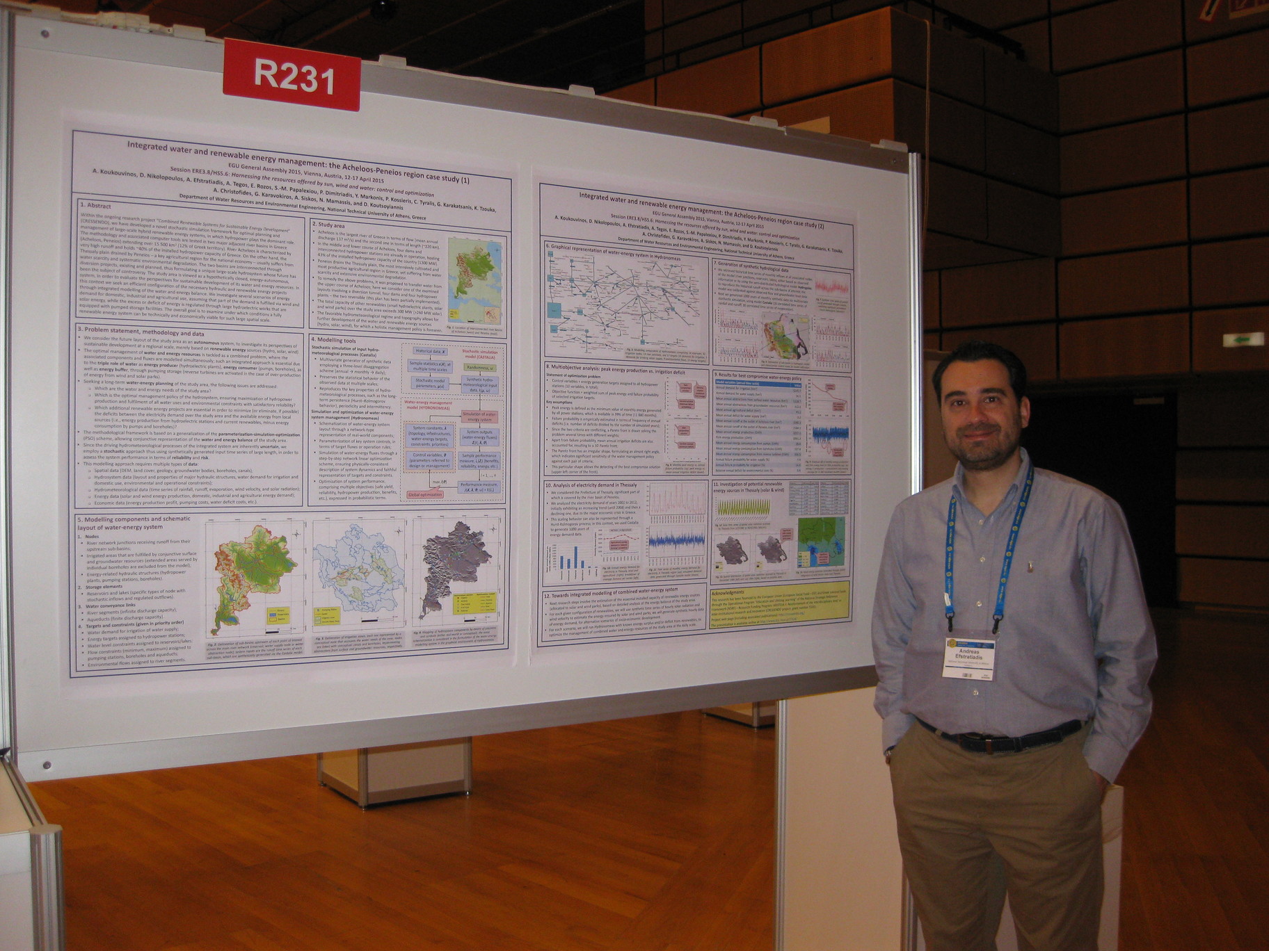
-
A. Efstratiadis, I. Tsoukalas, P. Kossieris, G. Karavokiros, A. Christofides, A. Siskos, N. Mamassis, and D. Koutsoyiannis, Computational issues in complex water-energy optimization problems: Time scales, parameterizations, objectives and algorithms, European Geosciences Union General Assembly 2015, Geophysical Research Abstracts, Vol. 17, Vienna, EGU2015-5121, doi:10.13140/RG.2.2.11015.80802, European Geosciences Union, 2015.
Modelling of large-scale hybrid renewable energy systems (HRES) is a challenging task, for which several open computational issues exist. HRES comprise typical components of hydrosystems (reservoirs, boreholes, conveyance networks, hydropower stations, pumps, water demand nodes, etc.), which are dynamically linked with renewables (e.g., wind turbines, solar parks) and energy demand nodes. In such systems, apart from the well-known shortcomings of water resources modelling (nonlinear dynamics, unknown future inflows, large number of variables and constraints, conflicting criteria, etc.), additional complexities and uncertainties arise due to the introduction of energy components and associated fluxes. A major difficulty is the need for coupling two different temporal scales, given that in hydrosystem modeling, monthly simulation steps are typically adopted, yet for a faithful representation of the energy balance (i.e. energy production vs. demand) a much finer resolution (e.g. hourly) is required. Another drawback is the increase of control variables, constraints and objectives, due to the simultaneous modelling of the two parallel fluxes (i.e. water and energy) and their interactions. Finally, since the driving hydrometeorological processes of the integrated system are inherently uncertain, it is often essential to use synthetically generated input time series of large length, in order to assess the system performance in terms of reliability and risk, with satisfactory accuracy. To address these issues, we propose an effective and efficient modeling framework, key objectives of which are: (a) the substantial reduction of control variables, through parsimonious yet consistent parameterizations; (b) the substantial decrease of computational burden of simulation, by linearizing the combined water and energy allocation problem of each individual time step, and solve each local sub-problem through very fast linear network programming algorithms, and (c) the substantial decrease of the required number of function evaluations for detecting the optimal management policy, using an innovative, surrogate-assisted global optimization approach.
Full text:
- http://www.itia.ntua.gr/en/getfile/1523/1/documents/EGU2015-5121.pdf: Abstract (36 KB)
- http://www.itia.ntua.gr/en/getfile/1523/2/documents/EGU2015_ComputIssues.pdf: Presentation (1198 KB)
-
A. Drosou, P. Dimitriadis, A. Lykou, P. Kossieris, I. Tsoukalas, A. Efstratiadis, and N. Mamassis, Assessing and optimising flood control options along the Arachthos river floodplain (Epirus, Greece), European Geosciences Union General Assembly 2015, Geophysical Research Abstracts, Vol. 17, Vienna, EGU2015-9148, European Geosciences Union, 2015.
We present a multi-criteria simulation-optimization framework for the optimal design and setting of flood protection structures along river banks. The methodology is tested in the lower course of the Arachthos River (Epirus, Greece), downstream of the hydroelectric dam of Pournari. The entire study area is very sensitive, particularly because the river crosses the urban area of Arta, which is located just after the dam. Moreover, extended agricultural areas that are crucial for the local economy are prone to floods. In the proposed methodology we investigate two conflicting criteria, i.e. the minimization of flood hazards (due to damages to urban infrastructures, crops, etc.) and the minimization of construction costs of the essential hydraulic structures (e.g. dikes). For the hydraulic simulation we examine two flood routing models, named 1D HEC-RAS and quasi-2D LISFLOOD, whereas the optimization is carried out through the Surrogate-Enhanced Evolutionary Annealing-Simplex (SE-EAS) algorithm that couples the strengths of surrogate modeling with the effectiveness and efficiency of the EAS method.
Full text:
- http://www.itia.ntua.gr/en/getfile/1522/1/documents/EGU2015-9148-1.pdf: Abstract (34 KB)
- http://www.itia.ntua.gr/en/getfile/1522/2/documents/Araxthos_EGU_2015_V0.2_DyP1tyN.pdf: Presentation (1404 KB)
Other works that reference this work (this list might be obsolete):
1. Xu, Z., P. Plink-Björklund, S. Wu, Z. Liu, W. Feng, K. Zhang, Z. Yang, and Y. Zhong, Sinuous bar fingers of digitate shallow‐water deltas: Insights into their formative processes and deposits from integrating morphological and sedimentological studies with mathematical modelling, Sedimentology, doi:10.1111/sed.12923, 2021.
-
G. Karakatsanis, N. Mamassis, and D. Koutsoyiannis, Entropy, recycling and macroeconomics of water resources, European Geosciences Union General Assembly 2014, Geophysical Research Abstracts, Vol. 16, Vienna, European Geosciences Union, 2014.
We develop a macroeconomic model of water quantity and quality supply multipliers derived from water recycling (Karakatsanis et al. 2013) and examine its statistical properties. Macroeconomic models that incorporate natural resource conservation have become increasingly important (European Commission et al. 2012) for national accounting. In addition, as an estimated 80% of globally used freshwater is not reused (United Nations 2012), with increasing population trends, water resource recycling becomes a solution of high priority. Recycling of water resources generates two major conservation effects: (1) conservation of water in reservoirs and aquifers and (2) conservation of ecosystem carrying capacity due to wastewater flux reduction. It is the properties of the distribution of recycling efficiencies –on quantity and quality- per sector that determine macroeconomic decoupling from geophysical uncertainty. Generally, uncertainty may statistically be quantified by entropy. Higher entropy signifies a greater dispersion of recycling efficiencies and potentially greater exposure to geophysical uncertainty; probably indicating the need for additional infrastructure for the statistical distribution’s both shifting and concentration towards higher efficiencies, supply multipliers and geophysical uncertainty decoupling.
Full text: http://www.itia.ntua.gr/en/getfile/1852/1/documents/EGU_2014_Karakatsanis_et_al_2.pdf (1012 KB)
Other works that reference this work (this list might be obsolete):
1. Karakatsanis, G., and C. Makropoulos Chemical leasing (Ch.L.) and the Sherwood plot, Resources, 13(5), 65, doi:10.3390/resources13050065, 2024. 2. Karakatsanis, G., D. Managoudis, and E. Makronikolakis, REGENA: Financial engineering for carbon farming, Land, 15(2), 349, doi:10.3390/land15020349, 2026.
-
A. Tegos, A. Efstratiadis, N. Malamos, N. Mamassis, and D. Koutsoyiannis, Evaluation of a parametric approach for estimating potential evapotranspiration across different climates, IRLA2014 – The Effects of Irrigation and Drainage on Rural and Urban Landscapes, Patras, doi:10.13140/RG.2.2.14004.24966, 2014.
Potential evapotranspiration (PET) is key input in water resources, agricultural and environmental modelling. For many decades, numerous approaches have been proposed for the consistent estimation of PET at several time scales of interest. The most recognized is the Penman-Monteith formula, which is yet difficult to apply in data-scarce areas, since it requires simultaneous observations of four meteorological variables (temperature, sunshine duration, humidity, wind velocity). For this reason, parsimonious models with minimum input data requirements are strongly preferred. Typically, these have been developed and tested for specific hydroclimatic conditions, but when they are applied in different regimes they provide much less reliable (and in some cases misleading) estimates. Therefore, it is essential to develop generic methods that remain parsimonious, in terms of input data and parameterization, yet they also allow for some kind of local adjustment of their parameters, through calibration. In this study we present a recent parametric formula, based on a simplified formulation of the original Penman-Monteith expression, which only requires mean daily or monthly temperature data. The method is evaluated using meteorological records from different areas worldwide, at both the daily and monthly time scales. The outcomes of this extended analysis are very encouraging, as indicated by the substantially high validation scores of the proposed approach across all examined data sets. In general, the parametric model outperforms well-established methods of the everyday practice, since it ensures optimal approximation of PET.
Full text: http://www.itia.ntua.gr/en/getfile/1512/1/documents/2014_IRLA_Parametric.pdf (740 KB)
-
G. Karakatsanis, N. Mamassis, D. Koutsoyiannis, and A. Efstratiadis, Entropy, pricing and macroeconomics of pumped-storage systems, European Geosciences Union General Assembly 2014, Geophysical Research Abstracts, Vol. 16, Vienna, EGU2014-15858-6, European Geosciences Union, 2014.
We propose a pricing scheme for the enhancement of macroeconomic performance of pumped-storage systems, based on the statistical properties of both geophysical and economic variables. The main argument consists in the need of a context of economic values concerning the hub energy resource; defined as the resource that comprises the reference energy currency for all involved renewable energy sources (RES) and discounts all related uncertainty. In the case of pumped-storage systems the hub resource is the reservoir’s water, as a benchmark for all connected intermittent RES. The uncertainty of all involved natural and economic processes is statistically quantifiable by entropy. It is the relation between the entropies of all involved RES that shapes the macroeconomic state of the integrated pumped-storage system. Consequently, there must be consideration on the entropy of wind, solar and precipitation patterns, as well as on the entropy of economic processes –such as demand preferences on either current energy use or storage for future availability. For pumped-storage macroeconomics, a price on the reservoir’s capacity scarcity should also be imposed in order to shape a pricing field with upper and lower limits for the long-term stability of the pricing range and positive net energy benefits, which is the primary issue of the generalized deployment of pumped-storage technology.
Full text:
- http://www.itia.ntua.gr/en/getfile/1443/1/documents/EGU2014-15858-6.pdf: Abstract (34 KB)
- http://www.itia.ntua.gr/en/getfile/1443/2/documents/EGU_2014_Karakatsanis_et_al_1.pdf: Presentation (3211 KB)
-
T. Tsitseli, D. Koutsoyiannis, A. Koukouvinos, and N. Mamassis, Construction of ombrian curves using the Hydrognomon software system, Facets of Uncertainty: 5th EGU Leonardo Conference – Hydrofractals 2013 – STAHY 2013, Kos Island, Greece, doi:10.13140/RG.2.2.34517.01762, European Geosciences Union, International Association of Hydrological Sciences, International Union of Geodesy and Geophysics, 2013.
Hydrognomon is an application for the analysis of hydrological data and includes several applications for time series processing, such as time step aggregation and regularization, interpolation, regression analysis and infilling of missing values, consistency tests, data filtering, graphical and tabular visualization of time series, etc. Both its source code and the executable program are freely available. The new version of Hydrognomon includes a module for the construction of ombrian (intensity-duration-frequency) curves. It is based on a mathematical framework that expresses ombrian curves with unified relationships giving rain intensity in terms of duration and return period, either for a single gauging station or for a station group over a specified area. In the latter case, it supports either single parameters set or spatially varying parameters. The framework is completed with raw rainfall data processing, data management and storage, graphical user interface, and output data graphs and export facilities.
Full text: http://www.itia.ntua.gr/en/getfile/1393/1/documents/2013Kos_Ombrian.pdf (725 KB)
Additional material:
- http://www.itia.ntua.gr/en/getfile/1393/2/documents/Tsitseli.JPG: Photo of the first author in front of the poster (819 KB)
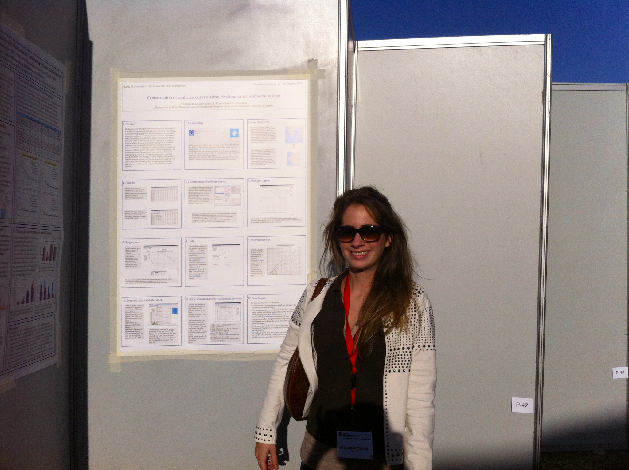
-
E. C. Moschou, S. C. Batelis, Y. Dimakos, I. Fountoulakis, Y. Markonis, S.M. Papalexiou, N. Mamassis, and D. Koutsoyiannis, Spatial and temporal rainfall variability over Greece, Facets of Uncertainty: 5th EGU Leonardo Conference – Hydrofractals 2013 – STAHY 2013, Kos Island, Greece, doi:10.13140/RG.2.2.19102.95045, European Geosciences Union, International Association of Hydrological Sciences, International Union of Geodesy and Geophysics, 2013.
The main objective of this study is to determine the major statistical properties of rainfall over Greece and analyse their variability through time. To this end, the following properties of rainfall variability were investigated on time series extracted from Hellenic National Meteorological Service records that date back to 1950: (1) the spatial correlation among the stations and the existence of regions which demonstrate homogeneity; (2) the temporal occurrence of maximum rainfall (the month which the daily maximum occurs) and the ratio of the daily maximum to the annual sum; (3) the spatial distribution of the daily maxima, which are observed in a number of stations simultaneously, as well as the rank correlation in space of annual rainfall; (4) the classification of the empirical distributions of daily maxima. The results of our analysis offer an improved overall picture of rainfall variability over Greece and help us clarify whether some attributes have changed over the last 60 years.
Full text: http://www.itia.ntua.gr/en/getfile/1392/1/documents/Kos_RainVariability_poster.pdf (1640 KB)
-
N. Bountas, N. Boboti, E. Feloni, L. Zeikos, Y. Markonis, A. Tegos, N. Mamassis, and D. Koutsoyiannis, Temperature variability over Greece: Links between space and time, Facets of Uncertainty: 5th EGU Leonardo Conference – Hydrofractals 2013 – STAHY 2013, Kos Island, Greece, doi:10.13140/RG.2.2.17739.80164, European Geosciences Union, International Association of Hydrological Sciences, International Union of Geodesy and Geophysics, 2013.
Temperature is strongly linked to the hydrological cycle in numerous ways and mainly with the evapotranspiration. Our aim here is to examine the possible influence of spatial characteristics on the temperature temporal variability of the monthly absolute maxima/minima and the monthly means over Greece. To achieve this, the temperature records of the Hellenic National Meteorological Service station network, which date back to 1950, are analysed. The analysis involved two steps: the determination of regions with similar climatic properties and the investigation of the possible correlations of temperature in time. Thus, the time series are classified in three groups based on their location (continental, coastal and island) and four types regarding the proximity of the station to a city (at the city centre, near the city border, far away from city border) or to an airport. Each one of the time series is then examined for (a) the influence of the city heat island as Greek cities expanded in time, (b) the effect of the general atmospheric circulation (NAO phase), (c) its correlation to the global temperature record and (d) the implied change on evapotranspiration in the area.
Full text: http://www.itia.ntua.gr/en/getfile/1391/1/documents/Kos_Temperature_poster_.pdf (2010 KB)
-
Y. Markonis, A. Efstratiadis, A. Koukouvinos, N. Mamassis, and D. Koutsoyiannis, Investigation of drought characteristics in different temporal and spatial scales: A case study in the Mediterranean region , Facets of Uncertainty: 5th EGU Leonardo Conference – Hydrofractals 2013 – STAHY 2013, Kos Island, Greece, European Geosciences Union, International Association of Hydrological Sciences, International Union of Geodesy and Geophysics, 2013.
In 1988-1995 Greece experienced a drought, one of the most extended (both in space and time) and intense since the beginning of hydro-meteorological instrumental measurements. The aim of this study is to describe the phenomenon in different temporal and spatial scales in order to (a) identify possible links with Mediterranean/global climatic regime and (b) to demonstrate the role of the marginal distribution and the autocorrelation function in estimating the return period of the drought and its impact. Three spatial scales were examined: the local scale (regions of Peloponnese in the southern and Macedonia in the northern part of Greece; ~2x2° each), the national scale (~8x8°) and the Mediterranean scale (~15x45°). In the time domain the monthly, annual and inter-annual time steps were taken, while the time horizon is that of the instrumental record as well as a broader time window obtained by introducing qualitative evidence from paleoclimatic studies. Our findings show both strong temporal variability and spatial heterogeneity, which imply enhanced uncertainty.
Full text: http://www.itia.ntua.gr/en/getfile/1390/1/documents/KosDroughtPoster.pdf (661 KB)
-
G. Karakatsanis, N. Mamassis, D. Koutsoyiannis, and A. Efstratiadis, Entropy and reliability of water use via a statistical approach of scarcity, Facets of Uncertainty: 5th EGU Leonardo Conference – Hydrofractals 2013 – STAHY 2013, Kos Island, Greece, doi:10.13140/RG.2.2.24450.68809, European Geosciences Union, International Association of Hydrological Sciences, International Union of Geodesy and Geophysics, 2013.
The paper examines economic reliability of water resource availability within a stochastic framework. Hoekstra and Mekonnen (2012) provide water use data for agricultural and industrial production. The current work utilizes these findings by coupling hydrological processes with reliability for economic use via a statistical approach of scarcity. Water extracted from the hydrological cycle is never bounded permanently, but only creates temporary scarcity via the competitive use of its limited economically useful attributes (such as its quality). The replenishment rate of freshwater reservoirs is limited and the return of water to its natural path requires energy inputs and time. Hence, what the economy is actually deprived of via the intensification of water use, the diversion of a water resource from its natural hydrological path and the eventual degradation after its use is its immediate availability, which is equivalent to increased uncertainty as the economy reaches closer to its natural water supply reliability limit. Georgescu-Roegen (1986) postulated a connection between increased dispersion and supply uncertainty of a resource to entropy, which in the case of water might be interpreted as increase of the probability of temporal unavailability.
Full text: http://www.itia.ntua.gr/en/getfile/1389/1/documents/Kos_Karakatsanis.pdf (736 KB)
See also: http://dx.doi.org/10.13140/RG.2.2.24450.68809
Other works that reference this work (this list might be obsolete):
1. Karakatsanis, G., and N. Mamassis, Energy, trophic dynamics and ecological discounting, Land, 12(10), 1928, doi:10.3390/land12101928, 2023. 2. Karakatsanis, G., D. Managoudis, and E. Makronikolakis, REGENA: Growth function for regenerative farming, Agriculture, 16(1),134, doi:10.3390/agriculture16010134, 2026.
-
A. Efstratiadis, A. Koukouvinos, P. Dimitriadis, A. Tegos, N. Mamassis, and D. Koutsoyiannis, A stochastic simulation framework for flood engineering, Facets of Uncertainty: 5th EGU Leonardo Conference – Hydrofractals 2013 – STAHY 2013, Kos Island, Greece, doi:10.13140/RG.2.2.16848.51201, European Geosciences Union, International Association of Hydrological Sciences, International Union of Geodesy and Geophysics, 2013.
Flood engineering is typically tackled as a sequential application of formulas and models, with specific assumptions and parameter values, thus providing fully deterministic outputs. In this procedure, the unique probabilistic concept is the return period of rainfall, which is set a priori, to represent the acceptable risk of all design variables of interest (peak flows, flood hydrographs, flow depths and velocities, inundated areas, etc.). Yet, a more consistent approach would require estimating the risks by integrating the uncertainties of all individual variables. This option can be offered by stochastic simulation, which is the most effective and powerful technique for analysing systems of high complexity and uncertainty. This presupposes to recognize which of the modelling components represent time-varying processes and which ones represent unknown, thus uncertain, parameters. In the proposed framework both should be handled as random variables. The following computational steps are envisaged: (a) generation of synthetic time series of areal rainfall, through multivariate stochastic disaggregation models; (b) generation of random sets of initial soil moisture conditions; (c) run of hydrological and hydraulic simulation models with random sets of parameter values, picked from suitable distributions; (d) statistical analysis of the model outputs and determination of empirical pdfs; and (e) selection of the design value, which corresponds to the acceptable risk. This approach allows for estimating the full probability distribution of the output variables, instead of a unique value, as resulted by the deterministic procedure. In this context, stochastic simulation also offers the means to introduce the missing culture of uncertainty appreciation in flood engineering.
Full text: http://www.itia.ntua.gr/en/getfile/1384/1/documents/KosFloodStochSim.pdf (1860 KB)
-
D. Panagoulia, N. Mamassis, and A. Gkiokas, Deciphering the floodplain inundation maps in Greece, 8th International Conference "Water Resources Management in an Interdisciplinary and Changing Context", Porto, Portugal, 8 pages, European Water Resources Association, 2013.
Floodplain inundation is caused by heavy rainfall, while its evolution depends mainly on land cover and geomorphologic characteristics of the river basins. The aim of this work is to decipher the similarities and differences of flood inundation maps that have been produced for various areas in Greece in the framework of the European Floods Directive (2007/60/EC). The adopted mapping methodology was accomplished through the use of the HECHMS software, which simulates the hydrologic processes of river basins and determines the design flood hydrographs for given return periods, as well as the HEC-RAS software, which simulates the hydraulics of open channel flow (computation of energy gradients and piezometric heads). Both packages are compatible with ArcGIS, which can be used for further data processing and visualization for cartographical purposes. The outcome of floodplain inundation mapping is anticipated to help in planning and prioritizing environmental and flood protection actions in a pre-disaster stage. The mentioned multi-methodology has been implemented to a great number of flood prone river basins in Greece. Flood maps, which can depict a variety of parameters, such as flood extent, water depths and piezometric heads for various return periods, were deciphered taking into account the specific characteristics of each area. The values of the aforementioned parameters are dependent on the (a) intense rainfall regime of the area (IDF curves), (b) geometrical characteristics of the river channel (cross sections areas, roughness, slope) and (c) geomorphologic, geological and soil characteristics of the flood plain (land cover, land use, elevations, slopes, soil permeability, hydraulic conductivity etc).
Full text: http://www.itia.ntua.gr/en/getfile/1373/1/documents/paper_pana.pdf (820 KB)
-
D. Serbis, C. Papathanasiou, and N. Mamassis, Flood mitigation at the downstream areas of a transboundary river, 8th International Conference "Water Resources Management in an Interdisciplinary and Changing Context", Porto, Portugal, 10 pages, European Water Resources Association, 2013.
Floods in the basin of Ardas river, a transboundary river that crosses Bulgaria and has its outlet in Greece, have often created havoc and caused millions of damage, especially in downstream Greek areas, which also repeatedly receive unregulated flow from upstream dams. More specifically, Ardas River, a tributary of Evros river, flows for 214 km in Bulgaria and for only 39 km in Greece and its catchment stretches for 5 250 km2 (94% of the total area) in Bulgaria and for 350 km2 (6% of the total area) in Greece. Three large dams along the river have been constructed in Bulgaria (Kardzhaly, Studen Kladenets and Ivaylovgrad), the last one, Ivaylovgrad dam, in short distance (approx. 15 km) from the transnational borders. During heavy rain, excessive flow from the Ivaylovgrad dam is often released downstream, in order to relieve the reservoir that is kept at maximum level for energy production reasons. As a result, the downstream areas, also affected by the same heavy rain events, need to regulate large flows, often with inadequate response time and relevant means. The present study presents an approach to estimate flood water levels in the Greek territory, caused by both rain events and releases from the upstream dam. For this purpose the study area was divided into three subbasins and the corresponding flood volumes were calculated using several methodologies. The paper concludes with a series of structural and non-structural measures that are suggested to be taken to confront and mitigate flood effects.
Full text: http://www.itia.ntua.gr/en/getfile/1372/1/documents/paper_ser.pdf (953 KB)
-
V. Pagana, A. Tegos, P. Dimitriadis, A. Koukouvinos, P. Panagopoulos, and N. Mamassis, Alternative methods in floodplain hydraulic simulation - Experiences and perspectives, European Geosciences Union General Assembly 2013, Geophysical Research Abstracts, Vol. 15, Vienna, EGU2013-10283-2, European Geosciences Union, 2013.
Floods can simply be defined as the physical phenomena, during which an initially dry land area is covered by water. Floods are normally caused by extreme weather conditions, while their evolution depends mainly on geomorphologic factors, such as soil stability, vegetation cover, as well as the geometrical characteristics of the river basin. To prevent floods’ consequences, we have to study the hydraulic behavior of all the basins. Here, the study is focused on the upstream part of the Rafina basin, located in the east of Athens (Greece). Particularly, a hydraulic simulation is accomplished via the one-dimensional HEC-RAS and the quasi-two-dimensional LISFLOOD-FP and FLO-2D models. Additionally, a sensitivity analysis is carried out to investigate the effects of the floodplain and river roughness coefficients on the flood inundation in conjunction with a modern probabilistic view. Finally, a comparison between the three models is made regarding the simulated maximum water depth and maximum flow velocity.
Full text:
- http://www.itia.ntua.gr/en/getfile/1347/1/documents/Alternative_methods_in_floodplain_hydraulic_simulation_pr.pdf: Presentation (4185 KB)
- http://www.itia.ntua.gr/en/getfile/1347/2/documents/Alternative_methods_in_floodplain_hydraulic_simulation_po.pdf: Poster (5049 KB)
- http://www.itia.ntua.gr/en/getfile/1347/3/documents/Alternative_methods_in_floodplain_hydraulic_simulation_ab.pdf: Abstract (33 KB)
Other works that reference this work (this list might be obsolete):
1. #Μίχας, Σ. Ν., Κ. Ι. Νικολάου, Σ. Λ. Λαζαρίδου, και Μ. Ν. Πικούνης, Σύγκριση μαθηματικών ομοιωμάτων διόδευσης πλημμυρικού κύματος από υποθετική θραύσης φράγματος Αγιόκαμπου, Πρακτικά 2ου Πανελλήνιου Συνεδρίου Φραγμάτων και Ταμιευτήρων, Αθήνα, Αίγλη Ζαππείου, Ελληνική Επιτροπή Μεγάλων Φραγμάτων, 2013.
-
A. Oikonomou, P. Dimitriadis, A. Koukouvinos, A. Tegos, V. Pagana, P. Panagopoulos, N. Mamassis, and D. Koutsoyiannis, Floodplain mapping via 1D and quasi-2D numerical models in the valley of Thessaly, Greece, European Geosciences Union General Assembly 2013, Geophysical Research Abstracts, Vol. 15, Vienna, EGU2013-10366, doi:10.13140/RG.2.2.25165.03040, European Geosciences Union, 2013.
The European Union Floods Directive defines a flood as ‘a covering by water of land not normally covered by water’. Human activities, such as agriculture, urban development, industry and tourism, contribute to an increase in the likelihood and adverse impacts of flood events. The study of the hydraulic behaviour of a river is important in flood risk management. Here, we investigate the behaviour of three hydraulic models, with different theoretical frameworks, in a real case scenario. The area is located in the Penios river basin, in the plain of Thessaly (Greece). The three models used are the one-dimensional HEC-RAS and the quasi two-dimensional LISFLOOD-FP and FLO-2D which are compared to each other, in terms of simulated maximum water depth as well as maximum flow velocity, and to a real flood event. Moreover, a sensitivity analysis is performed to determine how each simulation is affected by the river and floodplain roughness coefficient, in terms of flood inundation.
Full text:
- http://www.itia.ntua.gr/en/getfile/1337/1/documents/FloodplainMapping_pr.pdf: Presentation (7388 KB)
- http://www.itia.ntua.gr/en/getfile/1337/2/documents/FloodplainMapping_pos.pdf: Poster (9353 KB)
- http://www.itia.ntua.gr/en/getfile/1337/3/documents/FloodplainMapping_abs.pdf: Abstract (34 KB)
See also: http://dx.doi.org/10.13140/RG.2.2.25165.03040
Other works that reference this work (this list might be obsolete):
1. #Μίχας, Σ. Ν., Κ. Ι. Νικολάου, Σ. Λ. Λαζαρίδου, και Μ. Ν. Πικούνης, Σύγκριση μαθηματικών ομοιωμάτων διόδευσης πλημμυρικού κύματος από υποθετική θραύσης φράγματος Αγιόκαμπου, Πρακτικά 2ου Πανελλήνιου Συνεδρίου Φραγμάτων και Ταμιευτήρων, Αθήνα, Αίγλη Ζαππείου, Ελληνική Επιτροπή Μεγάλων Φραγμάτων, 2013.
-
A. Efstratiadis, A. D. Koussis, D. Koutsoyiannis, N. Mamassis, and S. Lykoudis, Flood design recipes vs. reality: Can predictions for ungauged basins be trusted? – A perspective from Greece, Advanced methods for flood estimation in a variable and changing environment, Volos, doi:10.13140/RG.2.2.19660.00644, University of Thessaly, 2012.
As a result of its highly fragmented geomorphology, Greece comprises hundreds of small- and medium-scale steep hydrological basins of usually ephemeral regime. Typically, their drainage area does not exceed few hundreds of km2, while the vast majority of them lacks of measuring infrastructures. For this reason, and despite the great scientific and technological advances in flood hydrology, the everyday engineering practices still follow simplistic rules-of-thumb and semi-empirical approaches, which are feasible and easy to implement in ungauged areas. In general, these “recipes” have been developed many decades ago, based on field data from few experimental catchments abroad. However, none of them has ever been validated against the peculiarities of the hydroclimatic regime and the geomorphological conditions of Greece. This has an obvious impact on the quality and reliability of hydrological studies, and, consequently, the safety and cost of the related flood-protection works. In order to provide a consistent design framework and ensure realistic predictions of the flood risk in ungauged basins (which is key issue of the 2007/60/EU Directive), it is imperative to revise the rather outdated engineering practices, by incorporating methodologies that are adapted to local peculiarities. In particular, the collection of reliable hydrological data is essential for evaluating and verifying the existing “recipes” and updating the design criteria. In this context, we are elaborating a research program titled “Deukalion”, in which we already have developed a fully-equipped monitoring network, extending over four pilot river basins. Preliminary outcomes, based on historical flood data from Cyprus and Greece, indicate that a substantial revision is required within multiple aspects of the flood modeling procedure.
Full text: http://www.itia.ntua.gr/en/getfile/1291/1/documents/FloodRecipesVolosConf2012.pdf (1465 KB)
-
M. Mathioudaki, A. Efstratiadis, and N. Mamassis, Investigation of hydrological design practices based on historical flood events in an experimental basin of Greece (Lykorema, Penteli), Advanced methods for flood estimation in a variable and changing environment, Volos, University of Thessaly, 2012.
Typically, the hydrological design procedure in ungauged basins comprises three computational steps: (a) the formulation of the design storm; (b) the estimation of the “effective” rainfall (direct runoff); and (c) the derivation of the flood hydrograph at the basin outlet. In particular, the most widespread approaches with regard to (b) and (c) are the Soil Conservation Service Curve Number (SCS-CN) method and the unit hydrograph (UH), respectively. The SCS-CN method extracts the effective from the total rainfall through an elementary model that uses two parameters, i.e. the curve number (CN), which determines the potential maximum soil moisture retention of the basin, and the initial abstraction, which is in general assumed as 20% of the later. Next, the effective rainfall is propagated through the UH, which is a linear response function employing the spatiotemporal transformation of the direct runoff across the basin. In the absence of flow data, synthetic UHs are employed, for which various empirical formulas exist, derived from hydrological investigations in experimental basins worldwide. Yet, the suitability of such regionalization approaches is questionable, when aiming to apply them in areas with substantially different hydroclimatic and geomorphological characteristics. This issue certainly involves small-scale Greek basins of ephemeral runoff, which are affected by relatively short yet intense storm events causing flash floods. The objective of our study is the evaluation of the aforementioned methods, on the basis of historical flood data from the experimental basin of Lykorema. The basin is located in Penteli Mountain and covers an area of 15.2 km2. It is equipped with three meteorological stations and two flow gauges, from which we selected 35 rainfall and flood events to analyze. In all events was shown that the use of the SCS-CN method, with typical parameter values, in conjunction with two well-known synthetic UHs (Snyder and British Hydrological Institute) provided unrealistic predictions. The key reasons were the significant overestimation of both the CN value and the initial abstraction rate, as well as the improper representation of the shape of the UHs (particularly their rising branch). In this respect, we attempted to adjust the SCS-CN method, given that the CN is not a constant but a variable that actually depends on the soil moisture conditions, while the initial abstraction ratio is rather minor. In addition, we developed a synthetic parametric UH, described by a linear rising branch and a logarithmic falling branch. This uses as inputs the time of concentration, estimated by the Giandotti formula, and another duration parameter, estimated via calibration. Following a multi-criteria optimization approach, we represented with high accuracy all the important aspects of the flood hydrographs, in terms of runoff volume, magnitude and location of the peak. Although the implementation of the proposed framework in the specific basin was quite satisfactory, there is much more work to be done for establishing consistent design practices and guidelines of general use. An ultimately important step is the development of pilot basins and the collection of reliable flood data, which will allow providing much more accurate models and formulas.
Full text: http://www.itia.ntua.gr/en/getfile/1290/1/documents/MathioudakiVolosConf2012.pdf (1750 KB)
-
S. Kozanis, A. Christofides, A. Efstratiadis, A. Koukouvinos, G. Karavokiros, N. Mamassis, D. Koutsoyiannis, and D. Nikolopoulos, Using open source software for the supervision and management of the water resources system of Athens, European Geosciences Union General Assembly 2012, Geophysical Research Abstracts, Vol. 14, Vienna, 7158, doi:10.13140/RG.2.2.28468.04482, European Geosciences Union, 2012.
The water supply of Athens, Greece, is implemented through a complex water resource system, extending over an area of around 4 000 km2 and including surface water and groundwater resources. It incorporates four reservoirs, 350 km of main aqueducts, 15 pumping stations, more than 100 boreholes and 5 small hydropower plants. The system is run by the Athens Water Supply and Sewerage Company (EYDAP). Over more than 10 years we have developed, information technology tools such as GIS, database and decision support systems, to assist the management of the system. Among the software components, “Enhydris”, a web application for the visualization and management of geographical and hydrometeorological data, and “Hydrognomon”, a data analysis and processing tool, are now free software. Enhydris is entirely based on free software technologies such as Python, Django, PostgreSQL, and JQuery. We also created http://openmeteo.org/, a web site hosting our free software products as well as a free database system devoted to the dissemination of free data. In particular, “Enhydris” is used for the management of the hydrometeorological stations and the major hydraulic structures (aqueducts, reservoirs, boreholes, etc.), as well as for the retrieval of time series, online graphs etc. For the specific needs of EYDAP, additional GIS functionality was introduced for the display and monitoring of the water supply network. This functionality is also implemented as free software and can be reused in similar projects. Except for “Hydrognomon” and “Enhydris”, we have developed a number of advanced modeling applications, which are also generic-purpose tools that have been used for a long time to provide decision support for the water resource system of Athens. These are “Hydronomeas”, which optimizes the operation of complex water resource systems, based on a stochastic simulation framework, “Castalia”, which implements the generation of synthetic time series, and “Hydrogeios”, which employs conjunctive hydrological and hydrogeological simulation, with emphasis to human-modified river basins. These tools are currently available as executable files that are free for download though the ITIA web site (http://itia.ntua.gr/). Currently, we are working towards releasing their source code as well, through making them free software, after some licensing issues are resolved.
Full text:
- http://www.itia.ntua.gr/en/getfile/1201/1/documents/2012EGUAthensWS-2-slides.pdf: Presentation (slide format) (1412 KB)
- http://www.itia.ntua.gr/en/getfile/1201/4/documents/2012EGUAthensWS-2.pdf: Presentation (poster format) (1411 KB)
Additional material:
- http://www.itia.ntua.gr/en/getfile/1201/2/documents/EGU2012-7158-2.pdf: Abstract (38 KB)
- http://www.itia.ntua.gr/en/getfile/1201/3/documents/Enhydris-EYDAP_slides.pdf: Summary (presentation slides) (91 KB)
-
E. Galiouna, A. Efstratiadis, N. Mamassis, and K. Aristeidou, Investigation of extreme flows in Cyprus: empirical formulas and regionalization approaches for peak flow estimation, European Geosciences Union General Assembly 2011, Geophysical Research Abstracts, Vol. 13, Vienna, 2077, European Geosciences Union, 2011.
The island of Cyprus has a typical Mediterranean, semi-arid climate, characterized, among others, by relatively short yet intense storm events causing flash floods. Current practices for the design of flood-protection works as well as flood risk assessment are based on regional approaches, which require a number of parameters that derive from the river basin characteristics. The main target of this work is to evaluate the existing empirical formulas for estimating those watershed parameters, emphasizing on the runoff coefficient and the time of concentration, which are typical inputs for most of the aforementioned tools, such as the rational and the unit hydrograph methods. For this purpose, we analyzed a large amount of hydrological and geographical data, provided by the Water Development Department and the Meteorological Service of Cyprus. This includes annual discharge maxima at 130 flow gauges and the corresponding rainfall data, intensity-duration-frequency (ombrian) curves for different regions of the island, and geographical information for 70 river basins (DEM, hydrographic network, land uses, geology and permeability). A preliminary statistical analysis of annual maxima data indicated that the empirical distribution functions of the flood discharges are much sharper than those of the corresponding rainfall depths, which denotes strongly nonlinearity of the rainfall-runoff mechanisms. In addition, we found that the existing peak runoff estimation methods fail to reproduce this kind of nonlinearity, thus leading to severe underestimation of flood risk. To handle this inconsistency it was necessary to revise the erroneous hypothesis that both the runoff coefficient and the time of concentration are constant properties of the basin. In reality, they depend not only to the constant geomorphological characteristics of the basin but also to the rainfall-runoff event itself. However, an analytical estimation of their actual values is impossible, since they are related to complex hydrological and hydraulic processes. For this reason, we examine the simple yet realistic assumption that the two variables are functions not to the event magnitude but to its return period. Using appropriate historical data, we attempt to establish improved empirical relationships for Cyprus, by fitting the simulated peak flow values to the observed ones.
Full text:
- http://www.itia.ntua.gr/en/getfile/1117/1/documents/EGU2011-2077.pdf: Abstract (37 KB)
- http://www.itia.ntua.gr/en/getfile/1117/2/documents/2011_egu_floodcyprus.pdf: Poster (680 KB)
-
Y. Markonis, D. Koutsoyiannis, and N. Mamassis, Orbital climate theory and Hurst-Kolmogorov dynamics, 11th International Meeting on Statistical Climatology, Edinburgh, doi:10.13140/RG.2.2.31312.30724, International Meetings on Statistical Climatology, University of Edinburgh, 2010.
Orbital climate theory, based mainly on the work of Milankovitch, is used to explain some features of long-term climate variability, especially those concerning the ice-sheet extent. The paleoclimatic time series, which describe the climate-orbital variability relationship, exhibit Hurst-Kolmogorov dynamics, also known as long-term persistence. This stochastic dynamics provides an appropriate framework to explore the reliability of statistical inferences, based on such time series, about the consistency of suggestions of the modern orbital theory. Our analysis tries to shed light on some doubts raised from the contradictions between the orbital climate theory and paleoclimatic data.
Full text:
- http://www.itia.ntua.gr/en/getfile/998/1/documents/2010IMSC_MilankHurstKolmogPos.pdf: Poster (6560 KB)
- http://www.itia.ntua.gr/en/getfile/998/2/documents/2010IMSC_MilankHurstKolmogPr.pdf: Presentation (1545 KB)
- http://www.itia.ntua.gr/en/getfile/998/3/documents/2010IMSC_MilankHurstKolmogPrSM.pdf: Presentation, for print (2679 KB)
-
A. Varveris, P. Panagopoulos, K. Triantafillou, A. Tegos, A. Efstratiadis, N. Mamassis, and D. Koutsoyiannis, Assessment of environmental flows of Acheloos Delta, European Geosciences Union General Assembly 2010, Geophysical Research Abstracts, Vol. 12, Vienna, 12046, doi:10.13140/RG.2.2.14849.66404, European Geosciences Union, 2010.
Acheloos, the river with the highest discharge among rivers of Greece, hosts three hydroelectric dams, while two more dams are under construction. In addition, there are plans for partial diversion of the river to a nearby water district, for irrigation and hydroelectric development. The Acheloos Delta is considered to be one of the most significant Mediterranean wetland habitats for its ecological importance, including fish fauna. In this case study we aim to redefine the ecological flow and propose an outflow management policy from the most downstream reservoir (Stratos), in order to preserve the ecosystem at the Acheloos Delta. A hydrological analysis is employed to reconstruct the natural discharge records along the river on a daily basis, accompanied by a detailed evaluation of alternative methodologies for the estimation of the ecological flow. Based on the results of the analyses, the corresponding water management policy is determined, taking into account the characteristics of the hydropower plan and the related hydraulic works.
Full text:
- http://www.itia.ntua.gr/en/getfile/963/1/documents/EGU2010-12046.pdf: Abstract (35 KB)
- http://www.itia.ntua.gr/en/getfile/963/2/documents/2010EGU_acheloos.pdf: Presentation (451 KB)
- http://www.itia.ntua.gr/en/getfile/963/3/documents/2010EGU_AcheloosPos.pdf: Poster (343 KB)
See also: http://dx.doi.org/10.13140/RG.2.2.14849.66404
Other works that reference this work (this list might be obsolete):
1. #Fourniotis, N. T., M. Stavropoulou-Gatsi and I. K. Kalavrouziotis, Acheloos River: The timeless, and since ancient period, contribution to the development and environmental upgrading of Western Greece, Proceedings 3rd IWA Specialized Conference on Water & Wastewater Technologies in Ancient Civilizations, Istanbul-Turkey, 420-428, 2012. 2. Fourniotis, N. T., A proposal for impact evaluation of the diversion of the Acheloos River on the Acheloos estuary in Western Greece, International Journal of Engineering Science and Technology, 4(4), 1792-1802, 2012. 3. Mentzafou A., E. Dimitriou, I. Karaouzas, and S. Zogaris, Impact assessment of floating photovoltaic systems on the water quality of Kremasta Lake, Greece, Hydrology, 12(4), 92, doi:10.3390/hydrology12040092, 2025.
-
S. Kozanis, A. Christofides, N. Mamassis, A. Efstratiadis, and D. Koutsoyiannis, Hydrognomon – open source software for the analysis of hydrological data, European Geosciences Union General Assembly 2010, Geophysical Research Abstracts, Vol. 12, Vienna, 12419, doi:10.13140/RG.2.2.21350.83527, European Geosciences Union, 2010.
Hydrognomon is a software tool for the processing of hydrological data. It is an open source application running on standard Microsoft Windows platforms, and it is part of the openmeteo.org framework. Data are imported through standard text files, spreadsheets or by typing. Standard hydrological data processing techniques include time step aggregation and regularization, interpolation, regression analysis and infilling of missing values, consistency tests, data filtering, graphical and tabular visualisation of time series, etc. It supports several time steps, from the finest minute scales up to decades; specific cases of irregular time steps and offsets are also supported. The program also includes common hydrological applications, such as evapotranspiration modelling, stage-discharge analysis, homogeneity tests, areal integration of point data series, processing of hydrometric data, as well as lumped hydrological modelling with automatic calibration facilities. Here the emphasis is given on the statistical module of Hydrognomon, which provides tools for data exploration, fitting of distribution functions, statistical prediction, Monte-Carlo simulation, determination of confidence limits, analysis of extremes, and construction of ombrian (intensity-duration-frequency) curves. Hydrognomon is available for download from http://hydrognomon.org/.
Full text:
- http://www.itia.ntua.gr/en/getfile/962/1/documents/EGU2010-12419.pdf: Abstract (36 KB)
- http://www.itia.ntua.gr/en/getfile/962/2/documents/EGU2010Hydrognomon_.pdf: Poster (1151 KB)
- http://www.itia.ntua.gr/en/getfile/962/3/documents/2010EGUHydrognomonSlides__.pdf: Poster converted to A4 slides (1665 KB)
See also: http://dx.doi.org/10.13140/RG.2.2.21350.83527
Other works that reference this work (this list might be obsolete):
1. #Sebastianelli, S., M. Giglioni, C. Mineo, and S. Magnald, On the hydrologic-hydraulic revaluation of large dams, International Conference of Numerical Analysis and Applied Mathematics 2015 (ICNAAM 2015), 1738, 430003-1–430003-4, doi:10.1063/1.4952216, 2016. 2. #Mineo, C., S. Sebastianelli, L. Marinucci, and F. Russo, Assessment of the watershed DEM mesh size influence on a large dam design hydrograph, AIP Conference Proceedings, 1738, 430003, 2016. 3. Tsitroulis, I., K. Voudouris, A. Vasileiou, C. Mattas, M. Sapountzis, and F. Maris, Flood hazard assessment and delimitation of the likely flood hazard zones of the upper part in Gallikos river basin, Bulletin of the Geological Society of Greece, 50(2), 995-1005, doi:10.12681/bgsg.11804, 2016. 4. López J. J., O. Delgado, and M. A. Campo, Determination of the IDF curves in Igueldo-San Sebastián. Comparison of different methods, Ingeniería del Agua, 22(4), 209-223, doi:10.4995/Ia.2018.9480, 2018. 5. Nyaupane, N., B. Thakur, A. Kalra, and S. Ahmad, Evaluating future flood scenarios using CMIP5 climate projections, Water, 10, 1866, doi:10.3390/w10121866, 2018. 6. Vargas, M. M., S. Beskow, T. L. Caldeira, L. de Lima Corrêa, and Z. Almeida da Cunha, SYHDA – System of Hydrological Data Acquisition and Analysis, Brazilian Journal of Water Resources, 24, e11, doi:10.1590/2318-0331.241920180152, 2019. 7. Houessou-Dossou, E. A. Y., J. M. Gathenya, M. Njuguna, and Z. A. Gariy, Flood frequency analysis using participatory GIS and rainfall data for two stations in Narok Town, Kenya, Hydrology, 6(4), 90, doi:10.3390/hydrology6040090, 2019. 8. López Díez, A., P. Máyer Suárez, J. Díaz Pacheco, and P. Dorta Antequera, Rainfall and flooding in coastal tourist areas of the Canary Islands (Spain), Atmosphere, 10(12), 809, doi:10.3390/atmos10120809, 2019. 9. Pamirbek, M., X. Chen, S. Aher, A. Salamat, P. Deshmukh, and C. Temirbek, Analysis of discharge variability in the Naryn river basin, Kyrgyzstan, Hydrospatial Analysis, 3(2), 90-106, doi:10.21523/gcj3.19030204, 2019. 10. Tadesse, M., Spatial and temporal variability analysis and mapping of reference evapotranspiration for Jimma Zone, Southwestern Ethiopia, International Journal of Natural Resource Ecology and Management, 6(3), 108-115, doi:10.11648/j.ijnrem.20210603.12, 2021. 11. Hayder, A. M., and M. Al-Mukhtar, Modelling the IDF curves using the temporal stochastic disaggregation BLRP model for precipitation data in Najaf City, Arabian Journal of Geosciences, 14, 1957, doi:10.1007/s12517-021-08314-6, 2021. 12. Bekri, E. S., P. Economou, P. C. Yannopoulos, and A. C. Demetracopoulos, Reassessing existing reservoir supply capacity and management resilience under climate change and sediment deposition, Water, 13(13), 1819, doi:10.3390/w13131819, 2021. 13. #Ridzuan, N. A. M., N. M. Noor, N. A. A. A. Rahim, I. A. M. Jafri, and D. Gyeorgy, Spatio-temporal variation of particulate matter (PM10) during high particulate event (HPE) in Malaysia, In: Mohamed Noor N., Sam S.T., Abdul Kadir A. (eds.), Proceedings of the 3rd International Conference on Green Environmental Engineering and Technology, Lecture Notes in Civil Engineering, 214, Springer, Singapore, doi:10.1007/978-981-16-7920-9_6, 2022. 14. Tegos, A., A. Ziogas, V. Bellos, and A. Tzimas, Forensic hydrology: a complete reconstruction of an extreme flood event in data-scarce area, Hydrology, 9(5), 93, doi:10.3390/hydrology9050093, 2022. 15. Nikas-Nasioulis, I., M. M. Bertsiou, and E. Baltas, Investigation of energy, water, and electromobility through the development of a hybrid renewable energy system on the island of Kos, WSEAS Transactions on Environment and Development, 18, 543-554, doi:10.37394/232015.2022.18.53, 2022. 16. Vangelis, H., I. Zotou, I. M. Kourtis, V. Bellos, and V. A. Tsihrintzis, Relationship of rainfall and flood return periods through hydrologic and hydraulic modeling, Water, 14(22), 3618, doi:10.3390/w14223618, 2022. 17. Reyes Flores, C. A., H. Ferreira Albuquerque Cunha, and A. Cavalcanti da Cunha, Hydrometeorological characterization and estimation of landfill leachate generation in the Eastern Amazon/Brazil, PeerJ, 11, e14686, doi:10.7717/peerj.14686, 2023. 18. Vargas, M. M., S. Beskow, M. M. de Moura, Z. A. da Cunha, T. L. C. Beskow, and J. P. de Morais da Silveira, GAM-IDF: a web tool for fitting IDF equations from daily rainfall data, International Journal of Hydrology Science and Technology, 16(1), 37-60, doi:10.1504/IJHST.2023.131882, 2023. 19. Carrasco, G. A., L. Villegas, J. Fernandez, J. Vallejos, and C. Idrogo, Assessment of parameters of the generalized extreme value distribution in rainfall of the Peruvian North, Revista Politécnica, 52(2), 99-112, doi:10.33333/rp.vol52n2.10, 2023. 20. Arinaitwe, M., and J. Okedi, IoT-based data and analytic hierarchy process to map groundwater recharge with stormwater, Water Science and Technology, 89(3), 529-547, doi:10.2166/wst.2024.017, 2024. 21. Pappa, D., A. Kallioras, and D. Kaliampakos, Water mismanagement in agriculture: a case study of Greece. Starting with “how” and "why", Al-Qadisiyah Journal For Agriculture Sciences, 14(1), 90-106, doi:10.33794/qjas.2024.149833.1175, 2024. 22. Al-Jalili, S. K., A. M. Hayder, and H. M. Zwain, Deriving rainfall IDF curves using modified Bartlett-Lewis rectangular pulses (BLRP) model for Babylon City, Iraq, Results in Engineering, 24, 103028, doi:10.1016/j.rineng.2024.103028, 2024. 23. Männikus, R., W. W. Wang, M. Eelsalu, F. Najafzadeh, H. Bihs, and T. Soomere, Modelling suitable layout for a small island harbour: A case study of Ruhnu in the Gulf of Riga, Eastern Baltic Sea, Latvian Journal of Physics and Technical Sciences, 61(6), 3-24, doi:10.2478/lpts-2024-0040, 2024. 24. Viigand, K., M. Eelsalu, and T. Soomere, Quantifying exposedness of the eastern Baltic Sea shores with respect to extremely high and low water levels, Estuarine, Coastal and Shelf Science, 319, 109267, doi:10.1016/j.ecss.2025.109267, 2025. 25. da Silva, M. E. S., S. Beskow, A. A. Rodrigues, and T. L. C. Beskow, Applicability of HEC-DSSVue for management of hydrological gaging network: A case study using sub-hourly rainfall datasets from southern Brazil, Engenharia Agrícola, 45, doi:10.1590/1809-4430-eng.agric.v45e20240143/2025, 2025. 26. Yankey, K. K., E. K. Nyantakyi, A. T. Kabo-bah, M. K. Domfeh, P. Antwi-Agyei, R. Andoh, N. O. B. Ackerson, S. I. I. K. Yeboah, A. Minkah-Amankwah, and T. Atta-Darkwa, Green roof as flood mitigation in Ghana, Natural Hazards, 121, 15069-15090, doi:10.1007/s11069-025-07389-8, 2025. 27. Hafezparast, M., S. Gord, and R. Ghobadian, Comparing random forest flood frequency analysis with regional flood frequency, Creager and SCS in Doab-Qazanchi, Kermanshah, Journal of Applied Research in Water and Wastewater, 12 (1), 86-95, doi:10.22126/arww.2025.11095.1349, 2025. 28. Luna-Chalán, A. A., and L. D. Cuenca-Tamayo, Redesign of a culvert that intercepts the Intervalles Road, in the El Tambo Parish, Revista Científica Ciencia y Método, 4(1), 357-370, doi:10.55813/gaea/rcym/v4/n1/156, 2026. 29. Pappa, D., A. Kallioras, and D. Kaliampakos, Water availability without reliability: Groundwater-dependent irrigation and governance challenges in the Arta plain, Greece, Water,18(5), 623, doi:10.3390/w18050623, 2026. 30. Koulouris, D., and N. Malamos, Bayesian additive regression trees for multi-depth soil moisture modeling, Agriculture, 16(10), 1120, doi:10.3390/agriculture16101120, 2026.
-
A. Tegos, N. Mamassis, and D. Koutsoyiannis, Estimation of potential evapotranspiration with minimal data dependence, European Geosciences Union General Assembly 2009, Geophysical Research Abstracts, Vol. 11, Vienna, 1937, doi:10.13140/RG.2.2.27222.86089, European Geosciences Union, 2009.
We develop a parametric expression which approximates the Penman-Monteith equation thus providing easy estimation of the potential evapotranspiration with minimal data requirements. Namely, the method requires as inputs the mean temperature and the extraterrestrial radiation, from which only the temperature needs to be measured. The model was applied on a monthly step in 37 meteorological stations of Greece for the periods 1968-1983 (calibration period) and 1984-1989 (validation period). The results are satisfactory as the efficiency is greater than 0.97 for all stations and for both calibration and validation periods. Initially, the parametric expression involves three parameters but regional analysis indicates that reduction to one or two parameters is possible and does not increase the error substantially. Using optimization and geographic interpolation through a geographical information system, the parameter values were mapped for the entire territory of Greece, which makes the method directly applicable to any site in the country, the only requirement being that mean temperature data be available.
Full text:
- http://www.itia.ntua.gr/en/getfile/905/1/documents/EGU2009-1937-3.pdf: Abstract (107 KB)
- http://www.itia.ntua.gr/en/getfile/905/2/documents/2009EGU_EvaporationPr.pdf: Presentation (512 KB)
- http://www.itia.ntua.gr/en/getfile/905/3/documents/2009EGU_EvaporationPrSm.pdf: Presentation, for print (448 KB)
- http://www.itia.ntua.gr/en/getfile/905/4/documents/2009EGU_EvaporationPos.pdf: Poster (463 KB)
See also: http://dx.doi.org/10.13140/RG.2.2.27222.86089
Other works that reference this work (this list might be obsolete):
1. Tabari, H., P. H. Talaee, P. Willems, and C. Martinez, Validation and calibration of solar radiation equations for estimating daily reference evapotranspiration at cool semi-arid and arid locations, Hydrological Sciences Journal, 2014.
-
G. G. Anagnostopoulos, D. Koutsoyiannis, A. Efstratiadis, A. Christofides, and N. Mamassis, Credibility of climate predictions revisited, European Geosciences Union General Assembly 2009, Geophysical Research Abstracts, Vol. 11, Vienna, 611, doi:10.13140/RG.2.2.15898.24009, European Geosciences Union, 2009.
In a recent study (Koutsoyiannis et al., On the credibility of climate predictions, Hydrological Sciences Journal, 53 (4), 671–684, 2008), the credibility of climate predictions was assessed based on comparisons with long series of observations. Extending this research, which compared the outputs of various climatic models to temperature and precipitation observations from 8 stations around the globe, we test the performance of climate models at over 50 additional stations. Furthermore, we make comparisons at a large sub-continental spatial scale after integrating modelled and observed series.
Remarks:
Please visit/cite the peer-reviewed version of this article:
Anagnostopoulos, G. G., D. Koutsoyiannis, A. Christofides, A. Efstratiadis, and N. Mamassis, A comparison of local and aggregated climate model outputs with observed data, Hydrological Sciences Journal, 55 (7), 1094–1110, 2010.
Related works:
- [168] Prior related presentation
- [49] Prior related publication
- [46] A comparison of local and aggregated climate model outputs with observed data
Full text:
- http://www.itia.ntua.gr/en/getfile/900/1/documents/EGU2009-611.pdf: Abstract (108 KB)
- http://www.itia.ntua.gr/en/getfile/900/2/documents/2009EGU_ClimatePr.pdf: Presentation (790 KB)
- http://www.itia.ntua.gr/en/getfile/900/3/documents/2009EGU_ClimatePrSm.pdf: Presentation, for print (758 KB)
- http://www.itia.ntua.gr/en/getfile/900/4/documents/2009EGU_ClimatePos.pdf: Poster (11079 KB)
See also: http://dx.doi.org/10.13140/RG.2.2.15898.24009
Other works that reference this work (this list might be obsolete):
1. Stockwell, D. R. B., Critique of Drought Models in the Australian Drought Exceptional Circumstances Report (DECR), Energy & Environment, 21 (5), 425-436, 2010.
-
D. Koutsoyiannis, N. Mamassis, A. Christofides, A. Efstratiadis, and S.M. Papalexiou, Assessment of the reliability of climate predictions based on comparisons with historical time series, European Geosciences Union General Assembly 2008, Geophysical Research Abstracts, Vol. 10, Vienna, 09074, doi:10.13140/RG.2.2.16658.45768, European Geosciences Union, 2008.
As falsifiability is an essential element of science (Karl Popper), many have disputed the scientific basis of climatic predictions on the grounds that they are not falsifiable or verifiable at present. This critique arises from the argument that we need to wait several decades before we may know how reliable the predictions will be. However, elements of falsifiability already exist, given that many of the climatic model outputs contain time series for past periods. In particular, the models of the IPCC Third Assessment Report have projected future climate starting from 1990; thus, there is an 18-year period for which comparison of model outputs and reality is possible. In practice, the climatic model outputs are downscaled to finer spatial scales, and conclusions are drawn for the evolution of regional climates and hydrological regimes; thus, it is essential to make such comparisons on regional scales and point basis rather than on global or hemispheric scales. In this study, we have retrieved temperature and precipitation records, at least 100-year long, from a number of stations worldwide. We have also retrieved a number of climatic model outputs, extracted the time series for the grid points closest to each examined station, and produced a time series for the station location based on best linear estimation. Finally, to assess the reliability of model predictions, we have compared the historical with the model time series using several statistical indicators including long-term variability, from monthly to overyear (climatic) time scales. Based on these analyses, we discuss the usefulness of climatic model future projections (with emphasis on precipitation) from a hydrological perspective, in relationship to a long-term uncertainty framework.
Remarks:
Please visit/cite the peer-reviewed version of this article:
Koutsoyiannis, D., A. Efstratiadis, N. Mamassis, and A. Christofides, On the credibility of climate predictions, Hydrological Sciences Journal, 53 (4), 671-684, 2008.
Blogs and forums that discussed this article during 2008:
- Koutsoyiannis 2008 Presentation (Steve McIntyre, Climate Audit)
- Multi-Decadal Global Model Predicted and Observed Indian Ocean Warming - Are They In Agreement? (Roger Pielke Sr., Climate Science, also quoted in Skeptical Science)
- Inconsistent With? One Answer (Roger Pielke, Jr., Prometheus: The Science Policy Weblog)
- Über die Zuverlässigkeit von Klimaprojektionen (Tomislav Rus, Oekologismus)
- Koutsoyiannis tests if Global Climate Models are scientific (Uncommon Descent)
- Climate Models Are Irrelevant, and Latest IPCC Models a Regression (Omniclimate, also featured in World Press)
- How Good Are Global Climate Models? (The Motley Fool Discussion Boards)
- How Reliable are those climate models? (Science a GoGo's Discussion Forums)
- Model outputs at annual and climatic scales are irrelevant with reality (TWO community)
- The Sound Of Settled Science (Small Dead Animals)
- New study reveals (again) that climate models don't reflect reality (MSNBC)
- Model predictions are much poorer than an elementary prediction based on the time average (Marginalized Action Dinosaur, also quoted in Blogging Canadians)
- Ten of the Best Climate Research Papers (Nine Peer-Reviewed): A Note from Cohenite (Jennifer Marohasy Blog)
- Wie realistisch sind Klimamodelle? (Klimablog)
- Vertrauen zu Models? (Klimablog)
- Les prédictions foireuses et foirées des modèles de l'IPCC (Z Forum)
- Modelos (Valdeperrillos)
- Klimamodeller, Karl Popper og falsifering (Forsiden - Aftenposten.no)
- Assessment of the reliability of climate predictions based on comparisons with historical timeseries (UD/RK Samhälls Debatt)
- Εξέταση της αξιοπιστίας των κλιματολογικών προβλέψεων (Oikologio.gr)
Blogs with comments about this article during 2008:
Real Climate 1, Real Climate 2, Prometheus: The Science Policy Weblog 2, Environmental Niche Modeling, Rabett Run, Internet Infidels Discussion Board, Science Forums, BBC News Blogs, Jim Miller on Politics, James' Empty Blog, Green Car Congress, Channel 4 Forums, Deltoid, Washington Post Blogs, Herald Sun Blogs 1, Herald Sun Blogs 2, Herald Sun Blogs 3, AccuWeather, Skeptical Science, Debunkers, Yahoo groups: AlasBabylon, Sciforums, Lughnasa, Jennifer Marohasy 2, Jennifer Marohasy 3, Jennifer Marohasy 4, Bruin Skeptics, Changement Climatique, Klimatika, JFER Forum, The Sydney Morning Herald Blogs: Urban Jungle
Errata: In slide 3 "regional projections" should read "geographically distributed projections" and the reference of figures to IPCC chapter 11 (Christensen et al., 2007) should change to Chapter 10 (Meehl et al., 2007; also in list of references in slide 20). In slide 11 "Albany, Florida" should read "Albany, Georgia" (thanks to QE in the Small Dead Animals blog who spotted them).
Related works:
- [167] Credibility of climate predictions revisited (follow up study)
- [49] On the credibility of climate predictions
Full text:
- http://www.itia.ntua.gr/en/getfile/850/1/documents/2008EGUClimaticPred.pdf: Abstract (7 KB)
- http://www.itia.ntua.gr/en/getfile/850/2/documents/2008EGU_ClimatePredictionPr_.pdf: Presentation (1320 KB)
- http://www.itia.ntua.gr/en/getfile/850/3/documents/2008EGU_ClimatePredictionPrSm_.pdf: Presentation, condensed version (1192 KB)
- http://www.itia.ntua.gr/en/getfile/850/4/documents/2008EGU_ClimatePredictionsPos_.pdf: Poster (7003 KB)
See also: http://dx.doi.org/10.13140/RG.2.2.16658.45768
Other works that reference this work (this list might be obsolete):
1. #Ekmann, J., and R.C. Dolence, Energy project risk amidst climate change regulatory uncertainty, 25th Annual International Pittsburgh Coal Conference, PCC – Proceedings, 2008. 2. #Taylor, P., Chill, a reassessment of global warming theory: does climate change mean the world is cooling, and if so what should we do about it?, Clairview Books, 404 pp., 2009. 3. #Howell, B., The Kyoto Premise and the catastrophic failure of rational, logical, and scientific thinking by essentially all scientists, Lies, Damned Lies, and Scientists: the Kyoto Premise example, Chapter A.1, 2011. 4. Bakker, A. M. R., and B. J. J. M. van den Hurk, Estimation of persistence and trends in geostrophic wind speed for the assessment of wind energy yields in Northwest Europe, Climate Dynamics, 39 (3-4), 767-782, 2012.
-
N. Zarkadoulas, D. Koutsoyiannis, N. Mamassis, and S.M. Papalexiou, Climate, water and health in ancient Greece, European Geosciences Union General Assembly 2008, Geophysical Research Abstracts, Vol. 10, Vienna, 12006, doi:10.13140/RG.2.2.31757.95207, European Geosciences Union, 2008.
In contrast to earlier ancient civilizations (Egypt, Mesopotamia, Indus) that flourished in water-abundant environments (large river valleys), ancient Greeks preferred to establish their settlements in dry, water-scarce sites. It seems to be a paradox that all major Greek cities during the several phases of the Greek civilization that lasted for millennia, were established in those areas that had the minimal rainfall across the continental and insular Greece. Although there exist some medium-scale rivers and lakes in Greece, there has been no major city close to them in Greek antiquity. It can be argued that in such choices, climate and health have been the main criteria: dry climates are generally more convenient to live and healthier as they protect the population from water-related diseases. The progress in Greek civilization has been closely connected to hygienic living standards and a comfortable lifestyle. To achieve these, both technological infrastructures and management solutions were developed. In Crete, hygienic technologies were practiced as early as in the Minoan period of the island (3500-1200 BC) and were followed in several other cases in mainland Greece and the Aegean islands. The technological frame created comprised: (a) bathrooms, toilets (resembling modern day ones with flushing devices) and other sanitary facilities; (b) urban wastewater management systems; and (c) underground aqueducts that ensure superior water quality and safety against pollution and sabotage. The importance attached to the hygienic use of water in ancient Greece is highlighted in the case of Athens, a city established in one of the driest places of Greece. The entire Peisistratean aqueduct (6th century BC), which transferred water from the Hymettos Mountain to the city center, was constructed as an underground channel. There were bathrooms, latrines and other sanitary facilities, both public and private. Finally, an extended wastewater management network connected every single building of the Athenian Agora to the so-called Great Drain. The whole infrastructure can only be compared to modern hygienic water systems, reestablished in Europe and North America from the second half of the nineteenth century AD.
Full text:
- http://www.itia.ntua.gr/en/getfile/848/1/documents/2008EGUAncientGreece.pdf: Abstract (8 KB)
- http://www.itia.ntua.gr/en/getfile/848/2/documents/2008EGU_AncientHealthPr.pdf: Presentation (3020 KB)
- http://www.itia.ntua.gr/en/getfile/848/3/documents/2008EGU_AncientHealthPrSm.pdf: Presentation, condensed version (2419 KB)
- http://www.itia.ntua.gr/en/getfile/848/4/documents/2008EGU_AncientHealthPos.pdf: Poster (4223 KB)
See also: http://dx.doi.org/10.13140/RG.2.2.31757.95207
Other works that reference this work (this list might be obsolete):
1. Founda, D., and C. Giannakopoulos, The exceptionally hot summer of 2007 in Athens, Greece—A typical summer in the future climate?, Global and Planetary Change, 67(3-4), 227-236, 2009. 2. #Parise, M., Underground aqueducts: A first preliminary bibliography around the world, Proceedings 3rd IWA Specialized Conference on Water & Wastewater Technologies in Ancient Civilizations, Istanbul, Turkey, 65-72, 2012. 3. #Antoniou, G. P., G. Lyberatos, E. I. Kanetaki, A. Kaiafa, K. Voudouris and A. N. Angelakis, History of urban wastewater and stormwater sanitation technologies in Hellas, Evolution of Sanitation and Wastewater Technologies through the Centuries, ed. by A.N. Angelakis and J.B. Rose, 99-146, IWA Publishing, London, 2014.
-
K. Hadjibiros, N. Mamassis, A. Koukouvinos, and E. Kyritsis, Data base for the Greek nature (FILOTIS), The NTUA in the lead of research and technology , Athens, 2007.
Full text: http://www.itia.ntua.gr/en/getfile/877/1/documents/paper_filot.pdf (192 KB)
-
N. Mamassis, C. Papathanasiou, and M. Mimikou, Hydrometeorological measurements network in Athens area (METEONET), The NTUA in the lead of research and technology , Athens, 2007, (in press).
Full text: http://www.itia.ntua.gr/en/getfile/876/1/documents/paper_meteonet.pdf (427 KB)
-
A. Efstratiadis, G. Karavokiros, S. Kozanis, A. Christofides, A. Koukouvinos, E. Rozos, N. Mamassis, I. Nalbantis, K. Noutsopoulos, E. Romas, L. Kaliakatsos, A. Andreadakis, and D. Koutsoyiannis, The ODYSSEUS project: Developing an advanced software system for the analysis and management of water resource systems, European Geosciences Union General Assembly 2006, Geophysical Research Abstracts, Vol. 8, Vienna, 03910, doi:10.13140/RG.2.2.24942.20805, European Geosciences Union, 2006.
The ODYSSEUS project (from the Greek acronym of its full title "Integrated Management of Hydrosystems in Conjunction with an Advanced Information System") aims at providing support to decision-makers towards integrated water resource management. The end-product comprises a system of co-operating software applications, suitable to handle a wide spectrum of water resources problems. The key methodological concepts are the holistic modelling approach, through the conjunctive representation of processes regarding water quantity and quality, man-made interventions, the parsimony of both input data requirements and system parameterization, the assessment of uncertainties and risks, and the extended use of optimization both for modelling (within various scales) and derivation of management policies. The core of the system is a relational database, named HYDRIA, for storing hydrosystem information; this includes geographical data, raw and processed time series, characteristics of measuring stations and facilities, and a variety of economic, environmental and water quality issues. The software architecture comprises various modules. HYDROGNOMON supports data retrieval, processing and visualization, and performs a variety of time series analysis tasks. HYDROGEIOS integrates a conjunctive hydrological model within a systems-oriented water management scheme, which estimates the available water resources at characteristic sites of the river basin and at the underlying aquifer. HYDRONOMEAS is the hydrosystem control module and locates optimal operation policies that minimize the risk and cost of decision-making. Additional modules are employed to prepare input data. DIPSOS estimates water needs for various uses (water supply, irrigation, industry, etc.), whereas RYPOS estimates pollutant loads from point and non-point sources, at a river basin scale. A last category comprises post-processing modules, for evaluating the proposed management policies by means of economical efficiency and water quality requirements. The latter include sophisticated models that estimate the space and time variation of specific pollutants within rivers (HERIDANOS) and lakes (LERNE), as well as simplified versions of them to be used within the hydrosystem simulation scheme. An interactive framework enables the exchange of data between the various modules, either off-line (through the database) or on-line, via appropriate design of common information structures. The whole system is in the final phase of its development and parts of it have been already tested in operational applications, by water authorities, organizations and consulting companies.
Full text:
- http://www.itia.ntua.gr/en/getfile/706/1/documents/2006EGUSoftwareAbs.pdf: Abstract (31 KB)
- http://www.itia.ntua.gr/en/getfile/706/2/documents/2006EGUSoftwarePoster.pdf: Poster (910 KB)
Additional material:
- http://www.itia.ntua.gr/en/getfile/706/3/documents/2006EGUOdysseasLeaflet.pdf: Broschure (306 KB)
-
N. Mamassis, Calculation of potential solar radiation from geomorphologic information for snow melting estimation, 7th Plinius Conference on Mediterranean Storms, Rethymnon, Crete, European Geosciences Union, 2005.
This paper concerns the improvement of solar radiation estimation at a water basin, considering not only the latitude, but also the specific geomorphologic characteristics of the area. A Geographical Information System (GIS) is used in order to calculate the potential solar radiation to each basin cell, for each hour of a mean year. The solar altitude and azimuth, the aspect and azimuth of all basin cells and the shadow effects due to the geomorphology, are considered for the calculations. The hourly estimations are integrated to daily, monthly and yearly basis in order to compare the potential solar radiation of different basins. Also the procedure can be used for the estimation of the true received radiation considering point measurements of solar radiation. This information is extremely useful in order to understand and predict the snow melting process at mountain basins.
Full text:
- http://www.itia.ntua.gr/en/getfile/695/1/documents/2005PliniusRadiationAbs.pdf: Abstract (4 KB)
- http://www.itia.ntua.gr/en/getfile/695/2/documents/2005PliniusRadiationPres.gif: Poster presentation (596 KB)
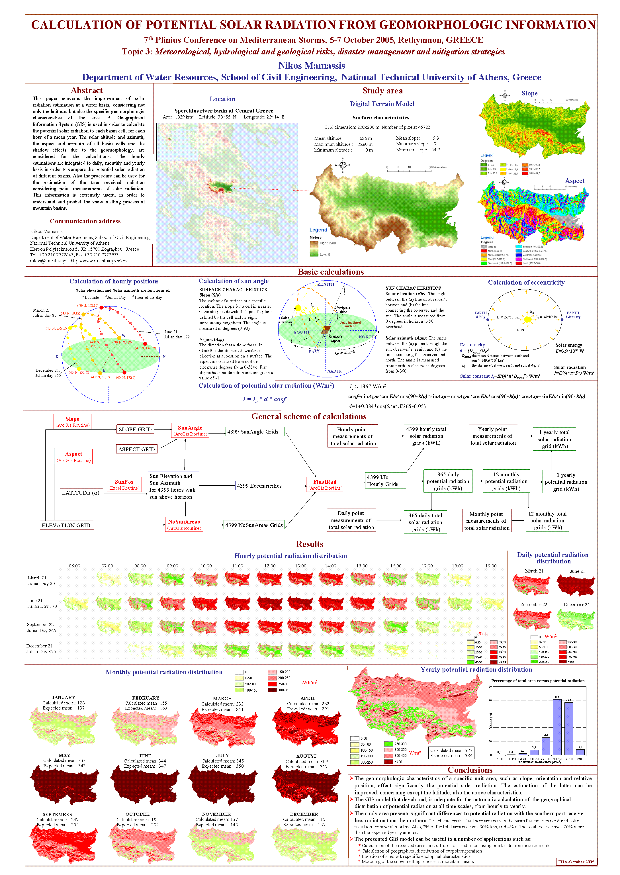
-
A. Efstratiadis, A. Tegos, I. Nalbantis, E. Rozos, A. Koukouvinos, N. Mamassis, S.M. Papalexiou, and D. Koutsoyiannis, Hydrogeios, an integrated model for simulating complex hydrographic networks - A case study to West Thessaly region, 7th Plinius Conference on Mediterranean Storms, Rethymnon, Crete, doi:10.13140/RG.2.2.25781.06881, European Geosciences Union, 2005.
An integrated scheme, comprising a conjunctive hydrological model and a systems oriented management model, was developed, based on a semi-distributed approach. Geographical input data include the river network, the sub-basins upstream of each river node and the aquifer dicretization in the form of groundwater cells of arbitrary geometry. Additional layers of distributed geographical information, such as geology, land cover and terrain slope, are used to define the hydrological response units. Various modules are combined to represent the main processes at the water basin such as, soil moisture, groundwater, flood routing and water management models. Model outputs include river discharges, spring flows, groundwater levels and water abstractions. The model can be implemented in daily and monthly basis. A case study to the West Thessaly region performed. The discharges of five hydrometric stations and the water levels of eight boreholes were used simultaneously for model calibration. The implementation of the model to the certain region demonstrated satisfactory agreement between the observed and the simulated data.
Full text:
- http://www.itia.ntua.gr/en/getfile/693/1/documents/2005PliniusHydrogeiosAbs.pdf: Abstract (4 KB)
- http://www.itia.ntua.gr/en/getfile/693/2/documents/2005PliniusHydrogeiosPres.pdf: Poster presentation (806 KB)
-
S. Kozanis, A. Christofides, N. Mamassis, A. Efstratiadis, and D. Koutsoyiannis, Hydrognomon - A hydrological data management and processing software tool, European Geosciences Union General Assembly 2005, Geophysical Research Abstracts, Vol. 7, Vienna, 04644, doi:10.13140/RG.2.2.34222.10561, European Geosciences Union, 2005.
Hydrognomon is a software tool for the management and analysis of hydrological data. It is built on a standard Windows platform based on client-server architecture; a database server is holding hydrological data whereas several workstations are executing Hydrognomon, sharing common data. Data retrieval, processing and visualisation are supported by a multilingual Graphical User Interface. Data management is based on geographical organisation to entities such as measuring stations, river basins, and reservoirs. Each entity may possess time series, physical properties, calculation parameters, multimedia content, etc. The main part of hydrological data analysis consists of time series processing applications, such as time step aggregation and regularisation, interpolation, regression analysis and filling in of missing values, consistency tests, data filtering, graphical and tabular visualisation of time series, etc. The program supports also specific hydrological applications, including evapotranspiration modelling, stage-discharge analysis, homogeneity tests, water balance methods, etc. The statistical module provides tools for sampling analysis, distribution functions, statistical forecast, Monte-Carlo simulation, analysis of extreme events and construction of intensity-duration-frequency curves. A final module is a lumped hydrological model, with alternative configurations, also supported by automatic calibration facilities. Hydrognomon is operationally used by the largest water organisation as well as technical corporations in Greece.
Full text:
- http://www.itia.ntua.gr/en/getfile/647/1/documents/2005EGUHydrognomonAbs.pdf: Abstract (29 KB)
- http://www.itia.ntua.gr/en/getfile/647/2/documents/2005EGUHydrognomon.pdf: Poster (276 KB)
- http://www.itia.ntua.gr/en/getfile/647/3/documents/2005EGUHydrognomonA4.pdf: Print friendly version, A4 (1492 KB)
See also: http://dx.doi.org/10.13140/RG.2.2.34222.10561
Other works that reference this work (this list might be obsolete):
1. #Zarris, D., Analysis of the environmental flow requirement incorporating the effective discharge concept, Proceedings of the 6th International Symposium on Environmental Hydraulics, Athens, 1125–1130, International Association of Hydraulic Research, National Technical University of Athens, 2010. 2. Puricelli, M., Update and analysis of intensity - duration - frequency curves for Balcarce, Buenos Aires province, Argentina, Revista de Geología Aplicada a la Ingeniería y al Ambiente, 32, 61-70, 2014. 3. Radevski, I., S. Gorin, O. Dimitrovska, I. Milevski, B. Apostolovska-Toshevska, M. Taleska, and V. Zlatanoski, Estimation of maximum annual discharges by frequency analysis with four probability distributions in case of non-homogeneous time series (Kazani karst spring in Republic of Macedonia), Acta Carsologica, 45(3), 253-262, doi:10.3986/ac.v45i3.1544, 2016. 4. #Mineo, C., S. Sebastianelli, L. Marinucci, and F. Russo, Assessment of the watershed DEM mesh size influence on a large dam design hydrograph, AIP Conference Proceedings, 1863, 470005, doi:10.1063/1.4992636, 2017. 5. #Matingo, T., W. Gumindoga, and H. Makurira, Evaluation of sub daily satellite rainfall estimates through flash flood modelling in the Lower Middle Zambezi Basin, Proc. IAHS, 378, 59–65, doi:10.5194/piahs-378-59-2018, 2018. 6. #Ummah, R., A. A. Kuntoro, and H. Alamsyah, Effect of water level elevation in Madiun river on flooding in Jeroan river, Proceedings of the 3rd ITB Graduate School Conference “Enhancing Creativity in Research Through Developing Innovative Capabilities”, 2(2), 315-328, 2022. 7. #Nikas-Nasioulis, I., and E. Baltas, Investigation of the energy coverage for wastewater treatment and desalination in the island of Kos based on a hybrid renewable energy system, Proceedings of 2nd World Conference on Sustainability, Energy and Environment, doi:10.33422/2nd.wscee.2022.12.120, 2022. 8. Sharma, A., and V. K. Vidyarthi, Comprehensive flood inundation mapping by integrating HEC-RAS and ArcGIS for a long stretch multi-tributary river system, ISH Journal of Hydraulic Engineering, doi:10.1080/09715010.2025.2610184, 2025.
-
A. Tsouni, D. Koutsoyiannis, C. Kontoes, N. Mamassis, and P. Elias, Application of satellite-based methods for estimating evapotranspiration in Thessalia plain, Greece, EGS-AGU-EUG Joint Assembly, Geophysical Research Abstracts, Vol. 5, Nice, doi:10.13140/RG.2.1.3221.7840, European Geophysical Society, 2003.
Estimation of evapotranspiration using both meteorological ground-based measurements and satellite-derived information has been widely studied during the last few decades and various methods have been developed for this purpose. In our application, we estimated the regional daily actual evapotranspiration during the 2001 summer season (June-August) over Thessalia plain in Pinios river basin. It is an area of intensive agricultural activity. Satellite data were accounted for those days that were available. For this case study, two different methods were applied and compared to the conventional and well-known FAO Penman-Monteith method. Satellite data, adequately processed (radiometric calibration, sun illumination conditions correction and geometric correction), were used in conjunction with ground data from the three nearest meteorological stations. The methods, which were properly adapted, exploit surface temperature and surface albedo assessments, obtained respectively from the infrared channels 4-5 and the visible channels 1-2 of NOAA-AVHRR images. The first method requires daily mean surface temperatures, so NOAA-15 satellite images were used, while for the second one the average rate of surface temperature rise during the morning is required, so a combination of NOAA-14 and NOAA-15 satellite images was used. The results of the study are quite encouraging, especially for the first method. In the future we intend to combine the satellite-derived data (Tsurf, Albedo, NDVI) with detailed land-use and land-cover classification map based on high-resolution satellite data.
Related works:
- [89] Posterior more complete version.
Full text:
- http://www.itia.ntua.gr/en/getfile/591/1/documents/2003EGSevaporation.pdf: Poster (A0, in colour) (840 KB)
- http://www.itia.ntua.gr/en/getfile/591/2/documents/2003EGSevaporationSM.pdf: Poster (reduced to A4, B/W) (331 KB)
-
K Mantoudi, N. Mamassis, and D. Koutsoyiannis, A simple water balance model using a geographical information system, 26th General Assembly of the European Geophysical Society, Geophysical Research Abstracts, Vol. 3, Nice, doi:10.13140/RG.2.2.26357.78567, European Geophysical Society, 2001.
A simple distributed water balance model is presented which simulates the hydrological processes in monthly time step using a geographical information system and its object oriented programming language. Model inputs (precipitation, temperature) and outputs (evapotranspiration, water storage in different conceptual reservoirs, runoff) are given in distributed format in grids with a cell size of 4 square kilometres. Successive transformations of precipitation are done assuming an interconnected system of hypothetical reservoirs representing snow accumulation, soil moisture and groundwater. The model uses only four parameters, namely imperviousness, soil storage capacity and recession coefficients of soil moisture and groundwater. The model is applied to the Acheloos River basin in Western Greece and measured river discharge at a hydrometric station is used for calibration and verification. Despite of its simplicity and parsimony of parameter the model yields a very satisfactory reproduction of measured discharge also providing accumulated runoff in any location of the river network by implementing utilities of a geographical information system.
Full text:
- http://www.itia.ntua.gr/en/getfile/56/1/documents/2001EGSGISModel.pdf: Presentation (456 KB)
- http://www.itia.ntua.gr/en/getfile/56/2/documents/2001EGSGISModelPost.pdf: Poster (2088 KB)
- http://www.itia.ntua.gr/en/getfile/56/3/documents/2001EGSGISModelSM.pdf: Presentation (for printer) (237 KB)
See also: http://dx.doi.org/10.13140/RG.2.2.26357.78567
Other works that reference this work (this list might be obsolete):
1. Zeng, W.-H., Q. Sun and Z.-F. Yang, Research on GRID-based dynamic water balance model of Jin River Basin, Journal of Arid Land Resources and Environment, 19 (5), 73-77. 2005.
-
D. Koutsoyiannis, and N. Mamassis, The scaling model of storm hyetograph versus typical stochastic rainfall event models, 24th General Assembly of the European Geophysical Society, Geophysical Research Abstracts, Vol. 1, The Hague, 769, doi:10.13140/RG.2.1.1192.2165, European Geophysical Society, 1999.
The scaling model of storm hyetograph (D. Koutsoyiannis and E. Foufoula-Georgiou, A scaling model of storm hyetograph, Water Resources Research, 29(7), 2345-2361, 1993) is fitted to short time scale point rainfall data of several regions. In addition, other typical descriptions of rainfall events with different stochastic structures are examined using the same data sets. The comparison provides evidence that the scaling model fits well to several rainfall data sets of regions with different climates and different population of storms (e.g. intense rainfall events only) and is superior to typical stochastic rainfall event models in capturing rainfall statistical properties even if they are not explicitly used for the model fitting.
Related works:
- [54] More complete posterior work.
Full text:
- http://www.itia.ntua.gr/en/getfile/67/1/documents/1999EGSScalingAbs.pdf: Page from the volume of abstracs (92 KB)
- http://www.itia.ntua.gr/en/getfile/67/2/documents/1999EGSScalingSM.pdf: Presentation (305 KB)
-
D. Koutsoyiannis, and N. Mamassis, Metsovo: The hydrological heart of Greece, Proceedings of the 1st Inter-university Conference for Metsovo, edited by D. Rokos, Metsovo, 209–229, doi:10.13140/RG.2.1.2928.9205, National Technical University of Athens Press – National Technical University of Athens, Athens, 1998.
The area of Metsovo is the place where the five most important river basins of Greece, those of Arachthos, Acheloos, Pinios, Aliakmon, and Aoos rivers adjoin. From this area the Metsovitikos, tributary of Arachthos, rises whereas in a short distance Acheloos, Aoos and some tributaries of Pinios and Aliakmon originate. Thus, metaphorically but with no exaggeration, we could say that the area of Metsovo is the hydrological heart of Greece, where the most important hydrological arteries start. In this study the surface water potential of the area, is appraised. To this aim, appropriate hydrological time series, especially those of rainfall and runoff, are examined using statistical tools. Moreover, the long term variability of time series is statistically tested to trace possible changes of their characteristics in the last forty years. Also the occurrence of extreme events is examined and also related to corresponding phenomena of other regions in Greece.
Full text:
- http://www.itia.ntua.gr/en/getfile/68/1/documents/1998Metsovo.pdf: Text (1266 KB)
- http://www.itia.ntua.gr/en/getfile/68/2/documents/1998MetsovoSM.pdf: Presentation (13786 KB)
-
N. Mamassis, and D. Koutsoyiannis, Weather types and geographical distribution of intense rainfall, Abstracts of the 5th International Conference on Precipitation, Elounda, Greece, 1.13, doi:10.13140/RG.2.1.1290.5208, 1995.
The spatial rainfall distribution is affected by the type of the prevailing weather situation as well as by local geographical factors, such us orography and latitude. The study of the areal distribution of rainfall is important especially when physiographic and climatological conditions vary over the same region causing different rainfall regimes. In this research, the influence of the prevailing weather type to the geographical distribution of the intense daily rainfall is studied. The study area is the Sterea Hellas region (Central Greece) and consists of three (among the fourteen) different water districts of Greece. The Pindos mountain chain in the west side of this region gives rise to heavy orographic rainfall and causes a wetter rainfall regime as compared with that of the east side. Daily data from 71 rain gages and hourly data from three rain recorders over a 20 year period are used. From these data sets, the intense rainfall events were extracted and analyzed. The intense rainfall days are classified according to the prevailing weather type using a daily calendar of synoptic weather types in Greece. Several methods (also including the available tools of a Geographical Information System) are used for the analysis and comparison of rainfall distributions. The results of these methods are statistically analyzed to trace similarities in geographical distribution of rainfall produced by a specific weather type, and dissimilarities in the distribution of rainfall produced by different weather types. Overall, the analysis shows that different weather types affect the location and other characteristics of rainfall in the study area.
Remarks:
Related works:
- [55] Μεταγενέστερη και πληρέστερη εργασία.
Full text: http://www.itia.ntua.gr/en/getfile/71/1/documents/1995PrecipConfWeathTyp.pdf (51 KB)
-
N. Mamassis, D. Koutsoyiannis, and I. Nalbantis, Intense rainfall and flood event classification by weather type, 19th General Assembly of the European Geophysical Society, Annales Geophysicae, Vol. 12, Supplement II, Part II, Grenoble, 440, doi:10.13140/RG.2.1.4124.9520, European Geophysical Society, 1994.
The influence of different weather types on intense rainfall and flood discharge is studied. Data from Western Greece are analysed, through a weather type classification that has been widely used in Greece. The probability of occurrence of intense rainfall events and flood events, conditional on the prevailing weather type, are calculated. Also, the statistics of the event characteristics are extracted and analysed through statistical tests and analysis of variance. The analyses show that there exist statistically significant differences in the probability of occurrence of an intense rainfall and flood event. However, the weather type concept does not explain significant portion of the variance of the event characteristics, such as rainfall duration, total depth, intensity, and discharge volume.
Related works:
- [92] Παρόμοια εργασία αλλά χωρίς αναφορά στα χαρακτηριστικά των πλημμυρικών επεισοδίων.
Full text:
- http://www.itia.ntua.gr/en/getfile/75/1/documents/1994EGSIntenseRainFldAbs.pdf: Page from volume of abstracts (113 KB)
- http://www.itia.ntua.gr/en/getfile/75/3/documents/1994EGSIntenseRainFld-ocr.pdf: Presentation (9353 KB)
Additional material:
- http://www.itia.ntua.gr/en/getfile/75/2/documents/1994EGSIntenseRainFld.pdf: Presentation (scanned) (9334 KB)
-
N. Mamassis, D. Koutsoyiannis, and E. Foufoula-Georgiou, Stochastic rainfall forecasting by conditional simulation using a scaling storm model, 19th General Assembly of the European Geophysical Society, Annales Geophysicae, Vol. 12, Supplement II, Part II, Grenoble, 324, 408, doi:10.13140/RG.2.1.1241.3682, European Geophysical Society, 1994.
Based on the recently developed scaling model of storm hyetograph, a conditional simulation scheme is presented, which can be used for stochastic forecasting of the temporal evolution of rainfall. The scaling model is fitted to hourly rainfall data of Greece and Italy. In addition, the model is tested for capturing statistical properties that are not explicitly used for the fitting. The scheme is formulated so as to use any information known for the rainfall event, as a condition for the simulation. The conditional simulation scheme is applied in two steps: first we generate the duration and total depth of the event and then we disaggregate the total depth into sequential hourly depths. Two different types of conditions are examined. The first one concerns the incorporation of preceding hourly rainfall depths. The second is related to information given by meteorological forecasts from which we can approximately estimate the duration and total depth of the event.
Full text:
- http://www.itia.ntua.gr/en/getfile/74/1/documents/1994EGSStocRainForecAbs.pdf: Page from volume of abstracts (112 KB)
- http://www.itia.ntua.gr/en/getfile/74/3/documents/1994EGSStocRainForec-ocr.pdf: Presentation (5869 KB)
Additional material:
- http://www.itia.ntua.gr/en/getfile/74/2/documents/1994EGSStocRainForec.pdf: Presentation (scanned) (5848 KB)
See also: http://dx.doi.org/10.13140/RG.2.1.1241.3682
Other works that reference this work (this list might be obsolete):
1. Nalbantis, I., Real-time flood forecasting with the use of inadequate data, Hydrological Sciences Journal, 45(2), 269-284, 2000.
-
N. Mamassis, S. Roti, D. Koutsoyiannis, and Th. Xanthopoulos, Hydrological characteristics of the Mornos, Evinos and Yliki basins, Workshop for the perspectives of resolving the water supply problem of Athens, edited by D. Koutsoyiannis, 55–64, doi:10.13140/RG.2.1.2177.3043, G. Fountas, 1990.
Full text: http://www.itia.ntua.gr/en/getfile/79/1/documents/1992EEDYPlekanes.pdf (466 KB)
See also: http://dx.doi.org/10.13140/RG.2.1.2177.3043
Other works that reference this work (this list might be obsolete):
1. Amanatidis, G. T., A. G. Paliatsos, C. C. Repapis, and J. G. Bartzis, Decreasing precipitation trend in the Marathon area, Greece, International Journal of Climatology, 13(2), 191-201, 1993.
-
S. Sigourou, V. Pagana, P. Dimitriadis, A. Tsouni, T. Iliopoulou, G.-F. Sargentis, R. Ioannidis, E. Chardavellas, D. Dimitrakopoulou, N. Mamassis, C. Kontoes, and D. Koutsoyiannis, Flood risk assessment in the region of Attica, 9th International Conference on Civil Protection & New Technologies - Safe Thessaloniki 2022, Thessaloniki, Greece, September 2022.
Full text: http://www.itia.ntua.gr/en/getfile/2238/1/documents/2022-09-29-FLOOD_RISK_ASSESSMENT_IN_THE_REGION_OF_ATTICA-presentation.pdf (8756 KB)
-
S. Sigourou, V. Pagana, P. Dimitriadis, A. Tsouni, T. Iliopoulou, G.-F. Sargentis, R. Ioannidis, E. Chardavellas, D. Dimitrakopoulou, N. Mamassis, C. Kontoes, and D. Koutsoyiannis, Proposed methodology for urban flood-risk assessment at river-basin level: the case study of the Pikrodafni river basin in Athens, Greece, Global Flood Partnership 2022 Annual Meeting, Leeds, UK, September 2022.
The need for and the complexity of flood protection works require the development of advanced methodologies for flood risk assessment, especially considering that land cover changes, climate change and human interventions in the riverbed may severely affect the river flow. In the present study, a new methodology for urban flood risk assessment is introduced and implemented at the Pikrodafni river basin (Athens, Greece), by analyzing the vulnerability and the exposure of the river basin of Pikrodafni’s river to flood risk, in conjunction with the actual physical and socioeconomic parameters in order to propose mitigation measures. In March 2021, a Programming Agreement was signed between the Prefecture of Attica and the NOA – Part A – to conduct the study entitled ARIA «Earthquake, Fire and Flood risk assessment in the region of Attica» funded by the Prefecture of Attica. It’s the first time that such a holistic approach for flood risk assessment is implemented on building-block scale in Greece. The prototype knowledge created through the project supports the Prefecture of Attica in the optimum implementation of the National Civil Protection Plan. This serves the operational needs during crisis, as well as the preparedness and the strategic decision making towards disaster resilience. All the above-mentioned factors were also confirmed and positively evaluated according to the stakeholders’ feedback.
Full text: http://www.itia.ntua.gr/en/getfile/2237/1/documents/FINposter_Proposed_methodology_for_urban_flood-risk_assessment.pdf (5618 KB)
Presentations and publications in workshops
-
N. Mamassis, G.-F. Sargentis, and D. Koutsoyiannis, Temporal evolution of the electric energy mix in Greece: From development to dependence, 11th Conference: "Theories, research and actions for the regeneration of mountainous and isolated areas", Metsovo, 19 pages, Metsovo, September 2025.
The technology of electricity arrived in Greece in 1889, with power generation relying on lignite, hydroelectric projects, and oil. Until 1950, private units supplied cities without an extensive grid. In 1950, the Public Power Corporation (PPC) was established, absorbing private companies and building units and networks. Viewing electricity as a social good, PPC electrified remote areas at low prices, contributing to development. The EU's neoliberal policy brought privatizations, including in the energy market. In 1999, the energy market was liberalized, and PPC was privatized. Subsequently, private natural gas and wind energy units emerged, while in 2012-13, the share of photovoltaics in the energy mix surged. The energy exchange, that followed, caused distortions and losses for PPC. The year 2050 is the final year referenced in the National Energy and Climate Plan (Ministry of Environment and Energy, 2024). The plan outlines the evolution of the energy mix over the next 25 years. Studying this evolution reveals long-term policies aimed at turning a social good into a commodity. Today, the country's dependence on imported fuels and the commodification of energy have led to high prices that harm the population. Unfortunately, the future looks bleak, as the National Plan foreshadows policies that will make the situation even more unfavorable.
Full text: http://www.itia.ntua.gr/en/getfile/2564/1/documents/mamassis_et_al_fin.pdf (1008 KB)
Additional material:
- http://www.itia.ntua.gr/en/getfile/2564/2/documents/mets_9_25.pdf: Presentation (1994 KB)
-
G.-F. Sargentis, P. Defteraios, N. D. Lagaros, and N. Mamassis, Values and costs in history, Stuff we don't mention in the normal course of studies, Rovies, National Technical University of Athens (NTUA), 2023.
Full text: http://www.itia.ntua.gr/en/getfile/2332/1/documents/rovies-2023-sargentis-et-al-values.pdf (1798 KB)
-
N. Mamassis, and G.-F. Sargentis, [No English title available], Stuff we don't mention in the normal course of studies, Rovies, National Technical University of Athens (NTUA), 2023.
Full text: http://www.itia.ntua.gr/en/getfile/2329/1/documents/rovies-2023-mamassis-sargentis-wef.pdf (1861 KB)
-
N. Mamassis, Communicating "climate change", Stuff we don't mention in the normal course of studies, Rovies, National Technical University of Athens (NTUA), 2023.
Full text: http://www.itia.ntua.gr/en/getfile/2313/1/documents/Rovies-2023-nikos-mamassis-epikoinwnia.pdf (7412 KB)
-
N. Mamassis, The influence of "climate change" on the energy mix, Stuff we don't mention in the normal course of studies, Rovies, National Technical University of Athens (NTUA), 2023.
Full text: http://www.itia.ntua.gr/en/getfile/2312/1/documents/Rovies-2023-nikos-mamassis-energy.pdf (2032 KB)
-
N. Mamassis, Climate and climate change: essentials, Stuff we don't mention in the normal course of studies, Rovies, National Technical University of Athens (NTUA), 2023.
Full text: http://www.itia.ntua.gr/en/getfile/2311/1/documents/Rovies-2023-nikos-mamassis-essentials.pdf (2479 KB)
-
N. Mamassis, Introduction to the water-energy-food nexus, Stuff we don't mention in the normal course of studies, Rovies, National Technical University of Athens (NTUA), 2023.
Full text: http://www.itia.ntua.gr/en/getfile/2310/1/documents/Rovies-2023-nikos-mamassis-wef.pdf (2771 KB)
-
N. Mamassis, The influence of "climate change" to energy mix, Event/discussion: climate crisis or the crisis as a governance technique?, Athens, 2023.
Presentation based on video "Electric Mix Tragedy in Greece" Link: https://youtu.be/u8xXq8J6SEE
Full text: http://www.itia.ntua.gr/en/getfile/2286/1/documents/Energy23.pdf (1288 KB)
-
N. Mamassis, The communication of "climate change", Event/discussion: climate crisis or the crisis as a governance technique?, Athens, 2023.
Full text: http://www.itia.ntua.gr/en/getfile/2285/1/documents/ClimateCom23.pdf (3164 KB)
-
D. Koutsoyiannis, T. Iliopoulou, A. Koukouvinos, N. Malamos, N. Mamassis, P. Dimitriadis, N. Tepetidis, and D. Markantonis, Extreme rainfall modelling for engineering design: a new methodology and its application over the Greek territory (invited), Risk Management: Extremes of Flood and Drought, Europe/China, UNESCO, 2023.
Remarks:
Video of presentation: https://www.iahr.org/video/clip?id=1500
Video of discussion: https://www.iahr.org/video/clip?id=1502
Videos of the entire event: https://www.iahr.org/video/clip?id=1496
Full text: http://www.itia.ntua.gr/en/getfile/2270/1/documents/UNESCO_China2.pdf (3617 KB)
-
A. Tsouni, S. Sigourou, V. Pagana, D. Koutsoyiannis, N. Mamassis, A. Koukouvinos, P. Dimitriadis, T. Iliopoulou, G.-F. Sargentis, R. Ioannidis, D. Dimitrakopoulou, E. Chardavellas, S. Vavoulogiannis, and V. Kyriakouli, Flood risk assessment in the Pikrodafni basin, Presentation of results for the 1st Phase of the Program Agreement between Attica Regional Authority and NOA, Athens, National Observatory of Athens, 2022.
Full text: http://www.itia.ntua.gr/en/getfile/2190/1/documents/20220516.pdf (13374 KB)
-
A. Efstratiadis, N. Mamassis, A. Koukouvinos, T. Iliopoulou, S. Antoniadi, and D. Koutsoyiannis, Strategic plan for developing a National Hydrometric Network, Hellenic Integrated Marine and Inland water Observing, Forecasting and offshore Technology System (HIMIOFoTS) - Second meeting of project partners, Department of Water Resources and Environmental Engineering – National Technical University of Athens, 2019.
Full text: http://www.itia.ntua.gr/en/getfile/1973/1/documents/NTUA_pres_June2019_PartB.pdf (2262 KB)
-
N. Mamassis, A. Efstratiadis, A. Koukouvinos, and D. Koutsoyiannis, Open Hydrosystem Information Network (OpenHi.net): Evolution of works, challeneges and perspectives, Hellenic Integrated Marine and Inland water Observing, Forecasting and offshore Technology System (HIMIOFoTS) - Second meeting of project partners, Department of Water Resources and Environmental Engineering – National Technical University of Athens, 2019.
-
D. Koutsoyiannis, N. Mamassis, and P. Defteraios, The evolution of water science and technology in ancient Athens, Hydrotechnologies in Ancient Greece, Chania, doi:10.13140/RG.2.2.31867.16167, Technical University of Crete, 2019.
Remarks:
Video from a visit to Hadrianic Aqueduct: https://youtu.be/n5Iaa90TNO0
Full text: http://www.itia.ntua.gr/en/getfile/1941/1/documents/2019TUC_ScienceTechnologyWaterAncientAthens.pdf (5073 KB)
-
N. Mamassis, and D. Koutsoyiannis, The tragedy of hydropower in Greece of crisis, Workshop of the Association of Thessalian Studies, Athens, 2019.
Full text: http://www.itia.ntua.gr/en/getfile/1931/1/documents/Trag_Hlektr_19.pdf (2873 KB)
-
N. Mamassis, Flood protection works or land use regulation for the prevention and mitigation of floods?, Natural disasters management: Priorities, rights, responsibilities, Harokopio University, Athens, 2019.
Full text: http://www.itia.ntua.gr/en/getfile/1929/1/documents/XarokopeioPlimmires_Rmup8YE.pdf (5954 KB)
-
N. Mamassis, A. Efstratiadis, D. Koutsoyiannis, and A. Koukouvinos, Open Hydrosystem Information Network (OpenHi.net), Hellenic Integrated Marine and Inland water Observing, Forecasting and offshore Technology System (HIMIOFoTS) - First meeting of project partners, Anavyssos, Hellenic Centre for Marine Research, 2018.
Full text: http://www.itia.ntua.gr/en/getfile/1872/1/documents/NTUA_pres_HCMR_Sep2018_dnpy8Eq.pdf (4637 KB)
-
N. Mamassis, and D. Koutsoyiannis, Book presentation: Evolution of Water Supply Through the Millennia, Temporal evolution of water management technologies for antiquity to present, Patra, Patras, 2017.
Remarks:
Video: https://www.youtube.com/watch?v=eKOU60boIW8
Full text: http://www.itia.ntua.gr/en/getfile/1762/1/documents/WS_par_patr.pdf (9625 KB)
-
N. Mamassis, Use of Geographical Information Systems to hydrologic design, 5th Hellenic Conference of Surveying Enginners, Athens, Athens, 2017.
Η χρήση των ΣΓΠ στην υδρολογία και την υδραυλική ξεκινάει από τα τέλη της δεκαετίας του 1980, όπου τα εργαλεία πληροφορικής αποκτούν ευρεία εφαρμογή σε όλες τις επιστήμες. Τα ΣΓΠ αποτέλεσαν όχι μόνο τις πρώτες γεωγραφικές βάσεις δεδομένων αλλά και εργαλεία εφαρμογής προσδιοριστικών και γεωστατιστικών μεθόδων στις περιοχές της υδρολογίας, της υδραυλικής και της διαχείρισης υδατικών πόρων. Σήμερα οι παραδοσιακές μεθοδολογίες υδρολογικού σχεδιασμού αλλά και τα παραδοσιακά υδρολογικά και υδραυλικά μοντέλα έχουν αναθεωρηθεί, ώστε να ενσωματώνουν άμεσα τη γεωγραφική πληροφορία και τη γεωστατιστική. Στην παρουσίαση γίνεται μια ιστορική αναδρομή της χρήσης των ΣΓΠ στον Τομέα Υδατικών Πόρων του ΕΜΠ, ως εκπαιδευτικών και υπολογιστικών εργαλείων, μέσα από διπλωματικές εργασίες και ερευνητικά έργα.
Full text: http://www.itia.ntua.gr/en/getfile/1748/1/documents/Gis_10_17.pdf (3715 KB)
-
A. Efstratiadis, A. Koukouvinos, N. Mamassis, and D. Koutsoyiannis, The quantitative dimension of WFD 2000/60, Water Framework Directive 2000/60 and Inland Water Protection: Research and Perspectives, Athens, Hellenic Centre for Marine Research, Specific Secreteriat of Water – Ministry of Environment, Energy and Climate Change, 2015.
Full text: http://www.itia.ntua.gr/en/getfile/1541/1/documents/2015_WFDQuantity1.pdf (787 KB)
-
A. Tegos, A. Efstratiadis, A. Varveris, N. Mamassis, A. Koukouvinos, and D. Koutsoyiannis, Assesment and implementation of ecological flow constraints in large hydroelectric works: The case of Acheloos, Ecological flow of rivers and the importance of their true assesment, 2014.
Full text: http://www.itia.ntua.gr/en/getfile/1455/1/documents/2014_envflows_pres.pdf (1344 KB)
-
N. Mamassis, A. Efstratiadis, and D. Koutsoyiannis, Perspectives of combined management of water and energy in Thessaly region, Water Resources Management Agency: A necessary modernization initiative but also a necessary condition for preserving the ecological balance, Larissa, 21 pages, doi:10.13140/RG.2.2.15760.61442, Technical Chamber of Greece / Department of CW Thessaly, 2014.
Full text: http://www.itia.ntua.gr/en/getfile/1434/1/documents/larissa_25_2.pdf (2206 KB)
-
N. Mamassis, and D. Koutsoyiannis, Exploration of ancient Greek hydraulic tecnhology using web-based data, Hydrotechnologies in Ancient Greece, edited by E. G. Kolokytha, Thessaloniki, 21 pages, Aristotle University of Thessaloniki, Thessaloniki, 2013.
Full text:
- http://www.itia.ntua.gr/en/getfile/1342/1/documents/thes22_3_13b.pdf: Presentation (5288 KB)
- http://www.itia.ntua.gr/en/getfile/1342/2/documents/Hmerida_Ancient_Technologies.pdf: Text (Workshop proceedings) (1983 KB)
-
A. D. Koussis, S. Lykoudis, A. Efstratiadis, A. Koukouvinos, N. Mamassis, D. Koutsoyiannis, A. Peppas, and A. Maheras, Estimating flood flows in ungauged Greek basins under hydroclimatic variability (Deukalion project) - Development of physically-established conceptual-probabilistic framework and computational tools, Climate and Environmental Change in the Mediterranean Region, Pylos, Navarino Environmental Observatory, 2012.
Full text: http://www.itia.ntua.gr/en/getfile/1292/1/documents/DeflkalionPoster.pdf (258 KB)
-
N. Mamassis, and D. Koutsoyiannis, Climatic uncertainty and water resources management - from science to divination, 23th general assembly EDEYA, Larisa, Larisa, 2011.
Full text: http://www.itia.ntua.gr/en/getfile/1155/1/documents/deya_2011b_1.pdf (4741 KB)
-
D. Koutsoyiannis, and N. Mamassis, Strategy for flood prevention: Modern technological framework, Integrated planning of flood protection: A challenge for the future, Athens, doi:10.13140/RG.2.2.27671.78242, Association of Civil Engineers of Greece, Athens, 2010.
Full text:
- http://www.itia.ntua.gr/en/getfile/972/1/documents/2010SPME_floods.pdf: Presentation (1323 KB)
- http://www.itia.ntua.gr/en/getfile/972/2/documents/2010SPME_floodsSM.pdf: Presentation, for print (1340 KB)
-
N. Mamassis, E. Tiligadas, D. Koutsoyiannis, M. Salahoris, G. Karavokiros, S. Michas, K. Noutsopoulos, A. Christofides, S. Kozanis, A. Efstratiadis, E. Rozos, and L. Bensasson, HYDROSCOPE: National Databank for Hydrological, Meteorological and Geographical Information, Towards a rational handling of current water resource problems: Utilizing Data and Informatics for Information, Hilton Hotel, Athens, 2010.
Full text:
- http://www.itia.ntua.gr/en/getfile/968/1/documents/tiligadas_NDBHMI_2010.pdf: Ε. Τηλιγάδας, ΕΤΥΜΠ: Ιστορικό και εξέλιξη (970 KB)
- http://www.itia.ntua.gr/en/getfile/968/2/documents/koutsoyiannis_2010HydroscopeXtesAyrio.pdf: Δ. Κουτσογιάννης, Υδροσκόπιο: Από το χθες στο αύριο (1064 KB)
- http://www.itia.ntua.gr/en/getfile/968/3/documents/salahoris_project.pdf: Μ. Σαλαχώρης, Συνολική παρουσίαση του έργου (2338 KB)
- http://www.itia.ntua.gr/en/getfile/968/4/documents/mamasis_intro.pdf: Ν. Μαμάσης, Η συμβολή του Υδροσκοπίου στην επίλυση υδατικών προβλημάτων (1554 KB)
- http://www.itia.ntua.gr/en/getfile/968/5/documents/karavokiros_site.pdf: Γ. Καραβοκυρός, Πλοήγηση στη διαδικτυακή εφαρμογή (426 KB)
- http://www.itia.ntua.gr/en/getfile/968/6/documents/michas_hmerida_.pdf: Σ. Μίχας, Στόχοι και προοπτικές του Υδροσκοπίου (182 KB)
- http://www.itia.ntua.gr/en/getfile/968/7/documents/noutsopoulos_presentation.pdf: Κ. Νουτσόπουλος, Σύνδεση με την Οδηγία 2000/60/EK (301 KB)
- http://www.itia.ntua.gr/en/getfile/968/8/documents/christophides_free.pdf: Α. Χριστοφίδης, Ελεύθερη πληροφορία, ελεύθερο λογισμικό: οφέλη και προκλήσεις (897 KB)
- http://www.itia.ntua.gr/en/getfile/968/9/documents/mamasis_data.pdf: Ν. Μαμάσης, Υδρομετεωρολογικά δεδομένα (1127 KB)
- http://www.itia.ntua.gr/en/getfile/968/10/documents/salahoris_gis.pdf: Μ. Σαλαχώρης, Το σύστημα γεωγραφικής πληροφορίας (9908 KB)
- http://www.itia.ntua.gr/en/getfile/968/11/documents/kozanis_timeseries.pdf: Σ. Κοζάνης, Διαχείριση υδρολογικών δεδομένων: από την πρωτογενή πληροφορία στη χρονοσειρά (334 KB)
- http://www.itia.ntua.gr/en/getfile/968/12/documents/efstratiadis_hydrol_analysis.pdf: Α. Ευστρατιάδης, Τυπικές και εξειδικευμένες υδρολογικές αναλύσεις (909 KB)
- http://www.itia.ntua.gr/en/getfile/968/13/documents/rozos_models.pdf: Ε. Ρόζος, Τα υδρολογικά μοντέλα του Υδροσκοπίου (1082 KB)
- http://www.itia.ntua.gr/en/getfile/968/14/documents/bensasson_melethtes.pdf: Λ. Μπενσασσών, Υδροσκόπιο: Εργαλείο για τις μελέτες υδραυλικών έργων και διαχείρισης υδατικών πόρων (333 KB)
-
D. Koutsoyiannis, N. Mamassis, and A. Tegos, Hydrometeorological issues in ancient Greek science and philosophy, The Eco-nomy of Water, edited by E Efthymiopoulos and M. Modinos, Hydra island, doi:10.13140/RG.2.2.25574.63040, Hellenica Grammata, 2009.
Technological applications aiming at the exploitation of the natural sources appear in all ancient civilizations. The unique phenomenon in the ancient Greek civilization is that technological needs triggered physical explanations of natural phenomena, thus enabling the foundation of philosophy and science. Among these, the study of hydrometeorological phenomena had a major role. This study begins with the Ionian philosophers in the seventh century BC, continues in classical Athens in the fifth and fourth centuries BC, and advances and expands through the entire Greek world up to the end of Hellenistic period. Many of the theories developed by ancient Greeks are erroneous according to modern views. However, many elements in Greek exegeses of hydrometeorological processes, such as evaporation and condensation of vapour, creation of clouds, hail, snow and rainfall, and evolution of hydrological cycle, are impressive even today.
Related works:
- [51] English text (publication in Water Science and Technology: Water Supply)
Full text:
-
A. Efstratiadis, D. Koutsoyiannis, and N. Mamassis, Optimization of the water supply network of Athens, Second International Congress: "Environment - Sustainable Water Resource Management", Athens, Association of Civil Engineers of Greece, European Council of Civil Engineers, 2007.
Full text:
- http://www.itia.ntua.gr/en/getfile/818/1/documents/2007SPME_AthensDSS.pdf: Presentation (831 KB)
- http://www.itia.ntua.gr/en/getfile/818/2/documents/2007SPME_AthensDSS_SM.pdf: Presentation (for printer) (668 KB)
-
D. Koutsoyiannis, A. Andreadakis, R. Mavrodimou, A. Koukouvinos, and N. Mamassis, The Master Plan for the water resource management of Greece (invited talk), International Conference: Integrated Management of Coastal Areas, Faliro, doi:10.13140/RG.2.2.30398.08005, CoPraNet, Mediterranean SOS, 2006.
Full text:
- http://www.itia.ntua.gr/en/getfile/741/1/documents/2006ConfCoastWRM.pdf: Presentation (967 KB)
- http://www.itia.ntua.gr/en/getfile/741/2/documents/2006ConfCoastWRMSM.pdf: Presentation, condensed version (887 KB)
-
D. Koutsoyiannis, A. Andreadakis, and N. Mamassis, ODYSSEUS: Information system for the simulation and management of hydrosystems, 15th meeting of the Greek users of Geographical Information Systems (G.I.S.) ArcInfo - ArcView - ArcIMS, Athens, doi:10.13140/RG.2.2.14145.15203, Marathon Data Systems, 2005.
Full text:
- http://www.itia.ntua.gr/en/getfile/690/1/documents/2005GISodysseus.pdf: Presentation (4482 KB)
- http://www.itia.ntua.gr/en/getfile/690/2/documents/2005GISposter.pdf: Poster (2534 KB)
- http://www.itia.ntua.gr/en/getfile/690/3/documents/2005GISodysseusSM.pdf: Presentation (for printer) (4358 KB)
-
N. Mamassis, and S Politaki, Evolution of water demand in the city of Athens, Water for the city: Strategic planning, demand management and network losses control, National Technical University of Athens, University of the Aegean, Water Supply and Sewerage Company of Athens, 2000.
Full text: http://www.itia.ntua.gr/en/getfile/393/1/documents/2000EMPWatConsum.pdf (226 KB)
-
K Mantoudi, N. Mamassis, and D. Koutsoyiannis, Water balance model of a catchment using geographical information system, 10th meeting of the Greek users of ArcInfo - ArcView, Marathon Data Systems, 2000.
Related works:
- [177] Μεταγενέστερη έκδοση στα αγγλικά.
Full text: http://www.itia.ntua.gr/en/getfile/86/1/documents/2000GISMantoudi.pdf (5035 KB)
-
D. Koutsoyiannis, N. Mamassis, and E. Arapaki, Water shortage in Ethiopia: A first approach, Solidarity for Ethiopia, doi:10.13140/RG.2.2.23556.12165, Hellas-Ethiopia, General Consulate of Ethiopia in Greece, 2000.
Full text: http://www.itia.ntua.gr/en/getfile/85/1/documents/2000Ethiopia.pdf (123 KB)
-
N. Mamassis, and D. Koutsoyiannis, Study of the geographical distribution of hydrometeorological variables using geographical information system, 5th meeting of the Greek users of ArcInfo, Marathon Data Systems, 1995.
Full text: http://www.itia.ntua.gr/en/getfile/97/1/documents/1995GISHydrometeo.pdf (9985 KB)
-
D. Koutsoyiannis, G. Tsakalias, A. Christofides, A. Manetas, A. Sakellariou, R. Mavrodimou, N. Papakostas, N. Mamassis, I. Nalbantis, and Th. Xanthopoulos, HYDROSCOPE: Creation of a national data bank of hydrological and meteorological information, Research and Technology Days '95, National Technical University of Athens, 1995.
Full text: http://www.itia.ntua.gr/en/getfile/94/1/documents/1995EMPhydroscopeXanth.pdf (435 KB)
-
D. Koutsoyiannis, N. Mamassis, and E. Foufoula-Georgiou, Rainfall modelling, Workshop for the presentation of the research project A comprehensive forecasting system for flood risk mitigation and control, Bologna, Italy, Università di Bologna, 1994.
Full text: http://www.itia.ntua.gr/en/getfile/102/1/documents/1994AforismRain.pdf (750 KB)
-
I. Nalbantis, N. Mamassis, D. Koutsoyiannis, E. Baltas, M. Aftias, M. Mimikou, and Th. Xanthopoulos, Hydrologic characteristics of the water shortage, The water supply problem of Athens, 13–28, Department of Water Resources, Hydraulic and Maritime Engineering – National Technical University of Athens, 1994.
Full text: http://www.itia.ntua.gr/en/getfile/100/1/documents/1994TomeasLeipsydria.pdf (1030 KB)
Other works that reference this work (this list might be obsolete):
1. #Schilling, W. and A. Mantoglou, Sustainable water management in an urban context, Drought management planning in water supply systems, E. Cabrera and J. Garcia-Serra (Ed.), Kluwer, 93-215, 1999.
-
N. Mamassis, and D. Koutsoyiannis, Some results on rainfall modelling - Univariate versus multivariate stochastic modelling of rainfall, 5th Meeting of AFORISM, Cork, Ireland, University College Cork, 1993.
Related works:
- [92] Συναφής στο μέρος που αφορά στην ανάλυση των τύπων καιρού.
Full text:
- http://www.itia.ntua.gr/en/getfile/104/1/documents/1993AforismRain.pdf: Presentation (4264 KB)
- http://www.itia.ntua.gr/en/getfile/104/2/documents/1993AforismRainSM.pdf: Presentation, condensed version (4196 KB)
Other works that reference this work (this list might be obsolete):
1. Nalbantis, I., Real-time flood forecasting with the use of inadequate data, Hydrological Sciences Journal, 45(2), 269-284, 2000.
-
N. Mamassis, and D. Koutsoyiannis, An attempt for stochastic forecasting of rainfall, 4th Meeting of AFORISM, Grenoble, Institut National Polytechnique de Grenoble, 1993.
Related works:
- [182] Εργασία με παρόμοιο περιεχόμενο.
Full text: http://www.itia.ntua.gr/en/getfile/103/1/documents/1993AforismGrenoble.pdf (1214 KB)
-
N. Mamassis, I. Nalbantis, and D. Koutsoyiannis, Investigation of hydrological characteristics of Mornos, Boeoticos Kephisos and Yliki basins, Water Supply of Athens, Association of Civil Engineers of Greece, Greek Union of Chemical Engineers, Association of the Greek Consulting Companies, 1992.
Full text: http://www.itia.ntua.gr/en/getfile/110/1/documents/1992SPMELekanes.pdf (884 KB)
-
D. Koutsoyiannis, I. Nalbantis, and N. Mamassis, Assessment of the risk for inadequacy of the water supply system of Athens in case of persistent drought, Likelihood of persistent drought and water supply of Athens, doi:10.13140/RG.2.2.13244.03207, Water Supply and Sewerage Company of Athens, 1992.
Full text: http://www.itia.ntua.gr/en/getfile/108/1/documents/1992EYDAPDrought.pdf (1874 KB)
Additional material:
- http://www.itia.ntua.gr/en/getfile/108/2/documents/1992_DroughtAthens_presentation.pdf: Presentation (465 KB)
-
I. Spyrakos, N. Mamassis, and D. Koutsoyiannis, Development of a geographical information system for hydrological data, 1st meeting of the Greek users of ArcInfo, Marathon Data Systems, 1991.
Full text: http://www.itia.ntua.gr/en/getfile/113/1/documents/1991GISSpyrakos.pdf (119 KB)
-
N. Mamassis, Aspects of hydroelectric power, Special Permanent Committee on Environmental Protection, Subcommitee on Water Resources, Hellenic Parliament, May 2016.
Full text: http://www.itia.ntua.gr/en/getfile/1881/1/documents/26_5_16_vouli.pdf (1837 KB)
-
N. Mamassis, Hydrological approach of Acheloos-Thessaly hydrosystem, The developmental role of the Acheloos diversion works, Karditsa, 14 March 2010.
Full text: http://www.itia.ntua.gr/en/getfile/969/1/documents/karditsa_03_10.ppt (2550 KB)
-
N. Mamassis, The hydrological cycle, Conference dedicated to the Universal day of water, Agios Nikolaos, DEYA of Agios Nikolaos, 23 March 2009.
Full text: http://www.itia.ntua.gr/en/getfile/909/1/documents/par_agnik.pdf (2624 KB)
Various publications
-
D. Koutsoyiannis, G.-F. Sargentis, N. Mamassis, and T. Iliopoulou, The importance of water in the historical development of science, Presentation for the Nishan Forum on Water Culture, doi:10.13140/RG.2.2.28165.67047, Qufu, China, July 2025.
In ancient Greece, Thales of Miletus declared water the fundamental element of life. For the first time in history, he studied a geophysical behaviour in scientific terms. This was the “Nile paradox”—why the Nile floods in summer, unlike other Mediterranean rivers. In China, scholars like Zou Yan, through the Five Elements theory and yin-yang, saw water as part of an interconnected system, essential to balance and renewal. Both cultures placed water at the heart of existence, sparking traditions of inquiry and observation. By rejecting divine explanations and seeking natural causes, Thales sparked a tradition of inquiry that culminated the final solution of the “Nile paradox” by Aristotle: the Nile’s floods were driven by monsoon rains in Ethiopia. For confirmation of his theory, the first scientific expedition in history was organized. This emphasis on empirical evidence and questioning assumptions can still be inspiring in the modern world. Aristotle also described how water evaporates, condenses, and returns as rain—noting that “the sea will never dry up” because water cycles continuously. He even made experiments, noting that salt water becomes fresh when evaporated. Similarly, China’s Taoist principles and the I Ching celebrate water’s cyclical flow, symbolizing harmony with nature. Practical ingenuity also defines both water cultures. In Greece, aqueducts were built in the 6th century BC, some enduring to this day. In China, the Dujiangyan irrigation system, constructed more than 2 000 years ago, remains a marvel of engineering, balancing human needs with the environment. These examples show us how to build resilient infrastructures. Both cultures valued clear thinking and harmony. Greek philosophers like Socrates and Aristotle sought precise understanding, much like Confucian ideals emphasize order and mutual respect. This common ground strengthens our ability to collaborate globally, ensuring that efforts to address water problems are holistic and effective. The water cultures of ancient Greece and China teach us to question assumptions, observe nature, build with resilience, and communicate clearly. By embracing these lessons, we can innovate and unite to prevent water disasters, enhance the benefits of water and restore ecosystems.
Full text: http://www.itia.ntua.gr/en/getfile/2545/1/documents/HistoricalDevelopmentOfScience_.pdf (2705 KB)
Additional material:
- http://www.itia.ntua.gr/en/getfile/2545/2/documents/Speech2.pdf: Related summary speech (157 KB)
-
N. Mamassis, and G.-F. Sargentis, Instructions for the presentation in laboratory of humanitarian studies (section history), Department of Water Resources and Environmental Engineering – National Technical University of Athens, 2023.
Full text: http://www.itia.ntua.gr/en/getfile/2366/1/documents/11_ergasies_ergastirio_anthropistikwn_spoudwn.pdf (1742 KB)
-
N. Mamassis, and G.-F. Sargentis, The subjectivity of money, Department of Water Resources and Environmental Engineering – National Technical University of Athens, 2023.
Full text: http://www.itia.ntua.gr/en/getfile/2364/1/documents/09_money_subjectivity.pdf (344 KB)
-
N. Mamassis, and G.-F. Sargentis, Money in history, Department of Water Resources and Environmental Engineering – National Technical University of Athens, 2023.
Full text: http://www.itia.ntua.gr/en/getfile/2363/1/documents/08_money_history.pdf (642 KB)
-
N. Mamassis, and G.-F. Sargentis, The role of food in prosperity, Department of Water Resources and Environmental Engineering – National Technical University of Athens, 2023.
Full text: http://www.itia.ntua.gr/en/getfile/2362/1/documents/07_wef_food.pdf (1088 KB)
-
N. Mamassis, and G.-F. Sargentis, The role of energy in prosperity, Department of Water Resources and Environmental Engineering – National Technical University of Athens, 2023.
Full text: http://www.itia.ntua.gr/en/getfile/2361/1/documents/06_wef_energy.pdf (1222 KB)
-
N. Mamassis, and G.-F. Sargentis, The role of water in prosperity, Department of Water Resources and Environmental Engineering – National Technical University of Athens, 2023.
Full text: http://www.itia.ntua.gr/en/getfile/2360/1/documents/05_wef_water.pdf (1083 KB)
-
N. Mamassis, and G.-F. Sargentis, Overpopulation and environmental determinism, Department of Water Resources and Environmental Engineering – National Technical University of Athens, 2023.
Full text: http://www.itia.ntua.gr/en/getfile/2358/1/documents/Environmental_Determinism.pdf (6310 KB)
-
N. Mamassis, and G.-F. Sargentis, The time as experience, 2023.
Full text: http://www.itia.ntua.gr/en/getfile/2357/1/documents/02_time_20230512.pdf (1538 KB)
-
G.-F. Sargentis, and N. Mamassis, Water collection in houses and complexes– Guidelines for the design in small scales, 75–80, 2021.
Full text: http://www.itia.ntua.gr/en/getfile/2131/1/documents/2021_ktirio_small_water.pdf (1076 KB)
-
S. Chrisoulaki, and N. Mamassis, Research on water supply of ancient Piraeus. Synthesis of approaches-Further research, 14 pages, 15 May 2015.
Full text: http://www.itia.ntua.gr/en/getfile/1551/1/documents/Pres_synth_5_1_fin.pdf (4454 KB)
-
N. Mamassis, P. Defteraios, N. Zarkadoulas, and D. Koutsoyiannis, Research on water supply of ancient Piraeus-Representation of ancient cisterns operation, 16 pages, doi:10.13140/RG.2.2.11392.64000, 15 May 2015.
Related works:
- [242]
Full text: http://www.itia.ntua.gr/en/getfile/1550/1/documents/Pres_cist_5_14_fin.pdf (2543 KB)
Books
-
A. N. Angelakis, L.W. Mays, D. Koutsoyiannis, and N. Mamassis, Evolution of Water Supply Through the Millennia, 560 pages, IWA Publishing, London, 2012.
Related works:
- [78] Prolegomena
- [77] A brief history of urban water management in ancient Greece
- [76] The evolution of water supply throughout the millennia: A short overview
Full text: http://www.itia.ntua.gr/en/getfile/1220/4/documents/wio9781780401041_TdR2M54.pdf (25221 KB)
See also: http://books.google.gr/books?id=WxXu83RxSNwC
Works that cite this document: View on Google Scholar or ResearchGate
Other works that reference this work (this list might be obsolete):
1. #Committee on Strategic Research for Integrated Water Resources Management, Delta Waters: Research to Support Integrated Water and Environmental Management in the Lower Mississippi River, Water Science and Technology Board - Division on Earth and Life Studies - National Research Council, The National Academies Press, 2013. 2. #Gibson, S., Charles Warren's Kidron Valley Tunnels, Bir Ayyub, and the Location of Biblical En Rogel, in: Exploring the Narrative: Jerusalem and Jordan in the Bronze and Iron Ages (ed. by N. Mulder, J. Boertien and E. van der Steen), Bloomsbury, London, 2014. 3. Freitas, L., M. J. Afonso, N. Devy-Vareta, J. M. Marques, A. Gomes and H. I. Chaminé, Coupling Hydrotoponymy and GIS Cartography: A Case Study of Hydrohistorical Issues in Urban Groundwater Systems, Porto, NW Portugal, Geographical Research, 10.1111/1745-5871.12051, 2014. 4. Angelakis , A. N., G. De Feo , P. Laureano and A. Zourou, Minoan and Etruscan hydro-technologies, Water, 5, 972-987, 10.3390/w5030972, 2013. 5. Mays, L. W., Use of cisterns during antiquity in the Mediterranean region for water resources sustainability, Water Science and Technology: Water Supply, 14 (1), 38-47, 2014. 6. Chaminé, H.I., M.J. Afonso and L. Freitas, From historical hydrogeological inventory through GIS mapping to problem solving in urban groundwater systems, European Geologist, 38, 31-39, 2014. 7. Mala-Jetmarova, H., A. Barton and A. Bagirov, A history of Water distribution systems and their optimization, Water Science and Technology: Water Supply, 15 (2), 224-235, 2015. 8. Kumar, P., Hydrocomplexity: Addressing water security and emergent environmental risks, Water Resour. Res., 51, 5827–5838, 10.1002/2015WR017342, 2015.
Educational notes
-
A. Efstratiadis, N. Mamassis, and P. Dimas, Lecture notes on Integrated Project in Hydraulic Engineering, 111 pages, Department of Water Resources and Environmental Engineering – National Technical University of Athens, December 2023.
Full text:
- http://www.itia.ntua.gr/en/getfile/2437/1/documents/IPHD_2022_Nomika.pdf: Γενικές αρχές νομοθεσίας μελετών δημοσίων έργων & περιεχόμενα φακέλου προμελέτης υδραυλικών έργων (694 KB)
- http://www.itia.ntua.gr/en/getfile/2437/2/documents/IPHD_2022_HydroData.pdf: Υδρομετεωρολογικά δεδομένα: Μετρητικές υποδομές & βασικές επεξεργασίες (2233 KB)
- http://www.itia.ntua.gr/en/getfile/2437/3/documents/HydrologicalModels.pdf: Υδρολογικές μελέτες & υδρολογικά μοντέλα (1084 KB)
- http://www.itia.ntua.gr/en/getfile/2437/4/documents/FloodHydrology.pdf: Υδρολογία πλημμυρών (1984 KB)
- http://www.itia.ntua.gr/en/getfile/2437/5/documents/IPHD_2023_Hydrodynamic_modelling.pdf: Βασικές αρχές υδροδυναμικής ανάλυσης (3915 KB)
-
N. Mamassis, and A. Efstratiadis, Lecture notes on "Introduction to Energy Engineering", 286 pages, Department of Water Resources and Environmental Engineering – National Technical University of Athens, November 2023.
Full text:
- http://www.itia.ntua.gr/en/getfile/2434/1/documents/ET2023_Intro.pdf: Γνωριμία με το μάθημα – Εισαγωγικές έννοιες (610 KB)
- http://www.itia.ntua.gr/en/getfile/2434/2/documents/ET2023_History.pdf: Ιστορία της ενέργειας (3317 KB)
- http://www.itia.ntua.gr/en/getfile/2434/3/documents/ET2023_ElectricEnergy.pdf: Ηλεκτρική ενέργεια: παραγωγή, μεταφορά, κατανάλωση (2002 KB)
- http://www.itia.ntua.gr/en/getfile/2434/4/documents/ET2023_Wind.pdf: Αιολική ενέργεια (2484 KB)
- http://www.itia.ntua.gr/en/getfile/2434/5/documents/ene_foto_2023.pdf: Ηλιακή ενέργεια (5705 KB)
- http://www.itia.ntua.gr/en/getfile/2434/6/documents/ET2021_Fossil.pdf: Ορυκτά καύσιμα και ενέργεια (2460 KB)
- http://www.itia.ntua.gr/en/getfile/2434/7/documents/ene_biomass21.pdf: Ενέργεια από βιομάζα (655 KB)
- http://www.itia.ntua.gr/en/getfile/2434/8/documents/ET2023_Hydropower.pdf: Υδροηλεκτρική ενέργεια και συστήματα νερού-ενέργειας (4913 KB)
- http://www.itia.ntua.gr/en/getfile/2434/9/documents/ene_geoth21.pdf: Γεωθερμική ενέργεια (1570 KB)
- http://www.itia.ntua.gr/en/getfile/2434/10/documents/ene_thal_2021.pdf: Θαλάσσια ενέργεια (2626 KB)
-
D. Koutsoyiannis, and N. Mamassis, The development of science (with emphasis on hydrology) from the Greek antiquity to the early modern period, Saarland University Germany, 73 pages, 2021.
Full text: http://www.itia.ntua.gr/en/getfile/2169/1/documents/2021DevelopmentOfHydrology.pdf (5631 KB)
-
A. Efstratiadis, N. Mamassis, and D. Koutsoyiannis, Lecture notes on Renewable Energy and Hydroelectric Works, Department of Water Resources and Environmental Engineering – National Technical University of Athens, 2020.
Remarks:
The course titled "Renewable Energy and Hydroelectric Works" is offered by the School of Civil Engineering (8th semester, optional) as well as the postgraduate program "Water Resources Science and Technology" (2nd semester).
Full text:
- http://www.itia.ntua.gr/en/getfile/2050/1/documents/01_Intro.pdf: Basic concepts of energy technology (1325 KB)
- http://www.itia.ntua.gr/en/getfile/2050/2/documents/02_HydropowerLayout.pdf: Hydroelectric energy - General layout of hydropower works (3785 KB)
- http://www.itia.ntua.gr/en/getfile/2050/3/documents/03_HydroelectricReservoirs.pdf: Hydroelectric reservoirs: technology and operation (2184 KB)
- http://www.itia.ntua.gr/en/getfile/2050/4/documents/04_SimulOptim.pdf: Simulation and optimization for the design and management of hydroelectric works (2032 KB)
- http://www.itia.ntua.gr/en/getfile/2050/5/documents/05_PenstokesTurbines.pdf: Penstokes and turbines (2331 KB)
- http://www.itia.ntua.gr/en/getfile/2050/6/documents/06_SmallHydro.pdf: Small hydropower plants (5433 KB)
- http://www.itia.ntua.gr/en/getfile/2050/7/documents/06_SmallHydroSupplementary.pdf: Hydrological design of small hydropower plants: Supplementary notes (253 KB)
- http://www.itia.ntua.gr/en/getfile/2050/8/documents/08_AeolicEnergy.pdf: Aeolic energy (1660 KB)
- http://www.itia.ntua.gr/en/getfile/2050/9/documents/09_SolarEnergy.pdf: Solar energy (1194 KB)
- http://www.itia.ntua.gr/en/getfile/2050/10/documents/10_EnergyStorage.pdf: Energy storage (1317 KB)
-
D. Koutsoyiannis, M. Pantazidou, N. Mamassis, G.-F. Sargentis, P. Thanopoulos, S. Lampropoulos, D Vamvatsikos, and K. Hadjibiros, Lecture Notes for the Laboratory on Humanities, School of Civil Engineering – National Technical University of Athens, Athens, 2020.
Full text:
- http://www.itia.ntua.gr/en/getfile/2032/10/documents/ScientificMethod6.pdf: Historical and Philosophical Introduction to the Scientific Method (D. Koutsoyiannis) (3094 KB)
- http://www.itia.ntua.gr/en/getfile/2032/20/documents/2020-TexnikiGrafi-Meros1_.pdf: Technical writing: objectives, language, references (M. Pantazidou) (1432 KB)
- http://www.itia.ntua.gr/en/getfile/2032/30/documents/2020-TexnikiGrafi-Meros2_.pdf: Technical writing: Standard texts (M. Pantazidou) (512 KB)
- http://www.itia.ntua.gr/en/getfile/2032/40/documents/Presentation_History_20260405.pdf: The evolution of man in history. Technology and perceptions (N. Mamassis, G.-F. Sargentis) (37065 KB)
- http://www.itia.ntua.gr/en/getfile/2032/50/documents/PolitikhTexnologia_2020-2021.pdf: Politics and technology (P. Thanopoulos and S. Lampropoulos,) (3601 KB)
- http://www.itia.ntua.gr/en/getfile/2032/60/documents/HumanitiesLab_Part05_Ethics_GR-1.pdf: Engineering ethics (D. Vamvatsikos) (374 KB)
- http://www.itia.ntua.gr/en/getfile/2032/70/documents/Thomas_Hobbes3_20_2021.pdf: Natural and built environment (K. Hadjibiros) (1391 KB)
Additional material:
- http://www.itia.ntua.gr/en/getfile/2032/1/documents/FirstLessonQuestions2.pdf: Some introductory questions for the Humanities Laboratory (568 KB)
- http://www.itia.ntua.gr/en/getfile/2032/80/documents/Sources_of_research-3.pdf: Sources of research (2401 KB)
-
A. Efstratiadis, G.-F. Sargentis, and N. Mamassis, Lecture notes on Environmental Impacts: Analysis of environmental impacts from large hydraulic structures, 37 pages, Department of Water Resources and Environmental Engineering – National Technical University of Athens, October 2019.
Full text: http://www.itia.ntua.gr/en/getfile/1993/1/documents/EnvImpacts2019_HydroWorks.pdf (2930 KB)
-
N. Mamassis, and A. Efstratiadis, Lecture notes on Energy Technology, 267 pages, Department of Water Resources and Environmental Engineering – National Technical University of Athens, Athens, October 2018.
Full text:
- http://www.itia.ntua.gr/en/getfile/1902/1/documents/ET2018_Intro.pdf: Introduction to energy technology (699 KB)
- http://www.itia.ntua.gr/en/getfile/1902/2/documents/ET2018_ElecticEnergy.pdf: Electric energy (2943 KB)
- http://www.itia.ntua.gr/en/getfile/1902/3/documents/ET2018_Fossil.pdf: Fossil fuels (1481 KB)
- http://www.itia.ntua.gr/en/getfile/1902/4/documents/ET2018_Hydropower.pdf: Hydraulic energy (5495 KB)
- http://www.itia.ntua.gr/en/getfile/1902/5/documents/ET2018_SolarEnergy.pdf: Solar energy (3715 KB)
- http://www.itia.ntua.gr/en/getfile/1902/6/documents/ET2018_AeolicEnergy_jkof8eQ.pdf: Aeolic energy (2674 KB)
- http://www.itia.ntua.gr/en/getfile/1902/7/documents/ET2018_Geotherm.pdf: Geothermic energy (1195 KB)
- http://www.itia.ntua.gr/en/getfile/1902/8/documents/ET2018_Biomass.pdf: Biomass energy (1579 KB)
- http://www.itia.ntua.gr/en/getfile/1902/9/documents/ET2018_MarineEnergy.pdf: Marine energy (2854 KB)
-
N. Mamassis, A. Efstratiadis, and D. Koutsoyiannis, Lecture notes on renewable Energy and Hydroelectric Works, 327 pages, Department of Water Resources and Environmental Engineering – National Technical University of Athens, 2018.
Full text:
- http://www.itia.ntua.gr/en/getfile/1843/1/documents/HW_REN18_EIS.pdf: Energy, electric energy and renewable energy (3453 KB)
- http://www.itia.ntua.gr/en/getfile/1843/2/documents/HW_REN18_HydropowerTechnology.pdf: Principles of hydropower technology (1146 KB)
- http://www.itia.ntua.gr/en/getfile/1843/3/documents/HW_REN18_SmallHydro.pdf: Technology of small hydroelectric works (5934 KB)
- http://www.itia.ntua.gr/en/getfile/1843/4/documents/HW16_MYHE_simul.pdf: Design of small hydroelectric works (1095 KB)
- http://www.itia.ntua.gr/en/getfile/1843/5/documents/HW_REN18_Reservoirs.pdf: Hydroelectric reservoirs (2608 KB)
- http://www.itia.ntua.gr/en/getfile/1843/6/documents/2015HydrologySimulOptim.pdf: Simulation and optimization for design and management of hydroelectric works (1367 KB)
- http://www.itia.ntua.gr/en/getfile/1843/7/documents/HW_REN18_Renewables.pdf: Wind power - Solar power - Biomass (3438 KB)
- http://www.itia.ntua.gr/en/getfile/1843/8/documents/HW14_EconomyF.pdf: Economics of energy (4171 KB)
-
N. Mamassis, A. Koukouvinos, and A. Efstratiadis, Lecture notes: Geographical Information Systems for Hydrology, School of Pedagogical & Technological Education (ASPAITE), 2017.
Full text: http://www.itia.ntua.gr/en/getfile/1935/1/documents/Aspaite_GIS.pdf (6633 KB)
-
N. Mamassis, Water control through history, August 2014.
Presentation in Summer school
Full text:
- http://www.itia.ntua.gr/en/getfile/1487/1/documents/hydrohistory1_per.pdf: 1 slide per page (16989 KB)
- http://www.itia.ntua.gr/en/getfile/1487/2/documents/hydrohistory2_per.pdf: 2 slides per page (5771 KB)
-
A. Efstratiadis, N. Mamassis, and D. Koutsoyiannis, Lecture notes on Water Resources Management - Part 2, 97 pages, Department of Water Resources, Hydraulic and Maritime Engineering – National Technical University of Athens, 2011.
Full text:
- http://www.itia.ntua.gr/en/getfile/763/1/documents/2007WRMSypplyDemand.pdf: Principles for the building of water resource management model - Supply-demand analysis (1175 KB)
- http://www.itia.ntua.gr/en/getfile/763/2/documents/2007WRMSypplyDemandSM.pdf: Principles for the building of water resource management model - Supply-demand analysis (for print) (847 KB)
- http://www.itia.ntua.gr/en/getfile/763/3/documents/2007WRMdss.pdf: Decision support systems in water resource management problems (1169 KB)
- http://www.itia.ntua.gr/en/getfile/763/4/documents/2007WRMdssSM.pdf: Decision support systems in water resource management problems (for print) (543 KB)
- http://www.itia.ntua.gr/en/getfile/763/5/documents/2007WRMDroughts.pdf: Droughts and their management (240 KB)
- http://www.itia.ntua.gr/en/getfile/763/6/documents/2007WRMDroughtsSM.pdf: Droughts and their management (for printer) (2463 KB)
- http://www.itia.ntua.gr/en/getfile/763/7/documents/FloodDirective.pdf: Flood Directive 2007/60 (1465 KB)
-
N. Mamassis, and D. Koutsoyiannis, Lecture notes on Hydrometeorology - Part 2, Edition 2, 176 pages, National Technical University of Athens, Athens, 2000.
Full text:
- http://www.itia.ntua.gr/en/getfile/117/1/documents/2009HydrometAtmosphere.pdf: General characteristics of the atmosphere (441 KB)
- http://www.itia.ntua.gr/en/getfile/117/2/documents/2012HydrometRadiation.pdf: Radiation in the atmosphere (2772 KB)
- http://www.itia.ntua.gr/en/getfile/117/3/documents/2009HydrometCirculation.pdf: Atmospheric circulation (4003 KB)
- http://www.itia.ntua.gr/en/getfile/117/4/documents/2010Hydrometwind.pdf: Wind and wind power (1781 KB)
- http://www.itia.ntua.gr/en/getfile/117/5/documents/2000HydrometPrecipitation.pdf: Precipitation (3014 KB)
- http://www.itia.ntua.gr/en/getfile/117/6/documents/2010HydrometClimatology.pdf: Introduction to climatology (2443 KB)
- http://www.itia.ntua.gr/en/getfile/117/7/documents/2009HydrometAtmosphereSM.pdf: General characteristics of the atmosphere, condensed version (440 KB)
- http://www.itia.ntua.gr/en/getfile/117/8/documents/2012HydromerRadiationSM.pdf: Radiation in the atmosphere, condensed version (2743 KB)
- http://www.itia.ntua.gr/en/getfile/117/9/documents/2009HydrometCirculationSM.pdf: Atmospheric circulation, condensed version (2166 KB)
- http://www.itia.ntua.gr/en/getfile/117/10/documents/2010HydrometwindSM.pdf: Wind and wind power, condensed version (B/W) (1529 KB)
- http://www.itia.ntua.gr/en/getfile/117/11/documents/2000HydrometPrecipitationSM.pdf: Precipitation, condensed version (1343 KB)
- http://www.itia.ntua.gr/en/getfile/117/12/documents/2010HydrometClimatologySM.pdf: Introduction to climatology, condensed version (1858 KB)
-
N. Mamassis, and D. Koutsoyiannis, Lecture notes on Advanced Hydrology - Part 2, 65 pages, National Technical University of Athens, Athens, 1999.
Full text:
- http://www.itia.ntua.gr/en/getfile/199/1/documents/1999AdvHydroArRainfall.pdf: Rainfall (745 KB)
- http://www.itia.ntua.gr/en/getfile/199/2/documents/1999AdvHydroRunoff.pdf: Runoff (339 KB)
- http://www.itia.ntua.gr/en/getfile/199/3/documents/1999AdvHydroArRainfallSM.pdf: Rainfall, condensed version (747 KB)
- http://www.itia.ntua.gr/en/getfile/199/4/documents/1999AdvHydroRunoffSM.pdf: Runoff, condensed version (435 KB)
Academic works
-
N. Mamassis, Rainfall analysis by weather type, PhD thesis, Department of Water Resources, Hydraulic and Maritime Engineering – National Technical University of Athens, Athens, 1997.
Full text: http://www.itia.ntua.gr/en/getfile/470/1/documents/1997mamasis.pdf (16936 KB)
Research reports
-
A. Efstratiadis, N. Mamassis, P. Dimas, A. Lykou, and G.-K. Sakki, Technical report, Development of computational infrastructure for the hydrodynamic simulation of the hydrosystem downstream of Asomata Dam, 82 pages, Department of Water Resources and Environmental Engineering – National Technical University of Athens, June 2024.
Related project: Development of computational infrastructure for the hydrodynamic simulation of the hydrosystem downstream of Asomata Dam
-
A. Efstratiadis, N. Mamassis, P. Dimas, A. Lykou, and G.-K. Sakki, Presentation of preliminary assessment results, Development of computational infrastructure for the hydrodynamic simulation of the hydrosystem downstream of Asomata Dam, Department of Water Resources and Environmental Engineering – National Technical University of Athens, April 2024.
Related project: Development of computational infrastructure for the hydrodynamic simulation of the hydrosystem downstream of Asomata Dam
-
D. Koutsoyiannis, T. Iliopoulou, A. Koukouvinos, N. Malamos, N. Mamassis, P. Dimitriadis, N. Tepetidis, and D. Markantonis, Technical Report, Production of maps with updated parameters of the ombrian curves at country level (implementation of the EU Directive 2007/60/EC in Greece), Department of Water Resources and Environmental Engineering – National Technical University of Athens, 2023.
Related project: Production of maps with updated parameters of the ombrian curves at country level (implementation of the EU Directive 2007/60/EC in Greece)
Full text: http://www.itia.ntua.gr/en/getfile/2273/1/documents/ntua_ombrian_reportF4.pdf (12849 KB)
Additional material:
- http://www.itia.ntua.gr/en/getfile/2273/2/documents/ombrian_parameters.zip: Grid of ombrian parameters across Greece (669 KB)
- http://www.itia.ntua.gr/en/getfile/2273/3/documents/MapMeanDailyRainfallGreece.zip: Grid of mean daily precipitation across Greece (599 KB)
-
A. Efstratiadis, N. Mamassis, G.-K. Sakki, I. Tsoukalas, P. Kossieris, P. Dimas, and N. Pelekanos, Master plan of water supply system of Athens - Hydrological year 2021-22, Modernization of the management of the water supply system of Athens - Update, 141 pages, Department of Water Resources and Environmental Engineering – National Technical University of Athens, June 2022.
Related project: Modernization of the management of the water supply system of Athens - Update
-
N. Mamassis, D. Koutsoyiannis, A. Efstratiadis, A. Koukouvinos, and I. Papageorgaki, Dissemination actions (papers, conferences), Open Hydrosystem Information Network (OpenHi.net), Contractor: Department of Water Resources and Environmental Engineering – National Technical University of Athens, 84 pages, October 2021.
This report includes the description of dissemination and publicity actions of the sub-project regarding the development and preliminary operation of the OpenHi.net information system. The actions include the public information seminar of the sub-project, three publications in international conferences and a publication in an international peer reviewed scientific journal.
Related project: Open Hydrosystem Information Network (OpenHi.net)
Full text: http://www.itia.ntua.gr/en/getfile/2157/1/documents/OpenHi_Report1.2.pdf (15937 KB)
-
N. Mamassis, and A. Koukouvinos, Diaries of internal meetings, Open Hydrosystem Information Network (OpenHi.net), Contractor: Department of Water Resources and Environmental Engineering – National Technical University of Athens, 30 pages, October 2021.
In this report detailed description of the meetings of the sub-project OpenHi.net team and the meetings with groups of related sub-projects in the framework of HIMIOFoTS, are described. All meetings are concerning the internal coordination of the project implementation team and the coordination of sub-projects directly related to the development and preliminary operation of the OpenHi.net web-based software system.
Related project: Open Hydrosystem Information Network (OpenHi.net)
Full text: http://www.itia.ntua.gr/en/getfile/2156/1/documents/OpenHi_Report1_1.pdf (629 KB)
-
N. Mamassis, A. Efstratiadis, A. Koukouvinos, and D. Koutsoyiannis, Technical report: Evaluation of the preliminary operation of OpenHi.net system, Open Hydrosystem Information Network (OpenHi.net), Contractor: Department of Water Resources and Environmental Engineering – National Technical University of Athens, 47 pages, October 2021.
The preliminary operation of the online information system OpenHi.net is evaluated based on the qualitative specifications and the corresponding operational requirements. In detail, the evaluation includes the functionality of the provided services and applications (for time series, statistical information, graphs, maps), the cooperation with measurement networks and third party databases, and the system's potential for expansion are evaluated.
Related project: Open Hydrosystem Information Network (OpenHi.net)
Full text: http://www.itia.ntua.gr/en/getfile/2154/1/documents/OpenHi_Report3.2Fin.pdf (2556 KB)
-
A. Efstratiadis, N. Mamassis, I. Tsoukalas, and S. Manouri, Special management study for the irrigation of the olive grove of Amfissa through the Mornos aqueduct, Modernization of the management of the water supply system of Athens - Update, Contractor: Department of Water Resources and Environmental Engineering – National Technical University of Athens, 35 pages, May 2021.
Related project: Modernization of the management of the water supply system of Athens - Update
-
A. Efstratiadis, I. Papakonstantis, P. Papanicolaou, N. Mamassis, D. Nikolopoulos, I. Tsoukalas, and P. Kossieris, First year synopsis, Modernization of the management of the water supply system of Athens - Update, Contractor: Department of Water Resources and Environmental Engineering – National Technical University of Athens, 55 pages, December 2020.
Related project: Modernization of the management of the water supply system of Athens - Update
-
A. Efstratiadis, N. Mamassis, and C. Makropoulos, Synoptic report on the estimation of the capacity of water supply system of Athens, Modernization of the management of the water supply system of Athens - Update, Contractor: Department of Water Resources and Environmental Engineering – National Technical University of Athens, 30 pages, October 2019.
Related project: Modernization of the management of the water supply system of Athens - Update
-
A. Efstratiadis, N. Mamassis, and I. Tsoukalas, Synoptic report on the evaluation of the flood risk for areas affected by the ongoing spilling of the Hylike-Paralimni system, Modernization of the management of the water supply system of Athens - Update, Contractor: Department of Water Resources and Environmental Engineering – National Technical University of Athens, 25 pages, March 2019.
Related project: Modernization of the management of the water supply system of Athens - Update
-
N. Mamassis, A. Efstratiadis, A. Koukouvinos, and D. Koutsoyiannis, Technical report: Development of a national monitoring system for surface water resources, Open Hydrosystem Information Network (OpenHi.net), Contractor: Department of Water Resources and Environmental Engineering – National Technical University of Athens, Τεύχος 2.1, June 2019.
Related project: Open Hydrosystem Information Network (OpenHi.net)
Full text:
- http://www.itia.ntua.gr/en/getfile/1977/1/documents/OpenHi_Report2_v1.pdf: Main report (8789 KB)
- http://www.itia.ntua.gr/en/getfile/1977/2/documents/OpenHi_Report2_annexEL01.pdf: Annex 1: Evaluation of hydrometric stations of WD01 (5085 KB)
- http://www.itia.ntua.gr/en/getfile/1977/3/documents/OpenHi_Report2_annexEL02.pdf: Annex 2: Evaluation of hydrometric stations of WD02 (4333 KB)
- http://www.itia.ntua.gr/en/getfile/1977/4/documents/OpenHi_Report2_annexEL03_AaZPROH.pdf: Annex 3: Evaluation of hydrometric stations of WD03 (1966 KB)
- http://www.itia.ntua.gr/en/getfile/1977/5/documents/OpenHi_Report2_annexEL04.pdf: Annex 4: Evaluation of hydrometric stations of WD04 (4489 KB)
- http://www.itia.ntua.gr/en/getfile/1977/6/documents/OpenHi_Report2_annexEL05_6HAGPsH.pdf: Annex 5: Evaluation of hydrometric stations of WD05 (5141 KB)
- http://www.itia.ntua.gr/en/getfile/1977/7/documents/OpenHi_Report2_annexEL06_KPv6TCu.pdf: Annex 6: Evaluation of hydrometric stations of WD06 (2916 KB)
- http://www.itia.ntua.gr/en/getfile/1977/8/documents/OpenHi_Report2_annexEL07.pdf: Annex 7: Evaluation of hydrometric stations of WD07 (2436 KB)
- http://www.itia.ntua.gr/en/getfile/1977/9/documents/OpenHi_Report2_annexEL08.pdf: Annex 8: Evaluation of hydrometric stations of WD08 (5453 KB)
- http://www.itia.ntua.gr/en/getfile/1977/10/documents/OpenHi_Report2_annexEL09.pdf: Annex 9: Evaluation of hydrometric stations of WD09 (7317 KB)
- http://www.itia.ntua.gr/en/getfile/1977/11/documents/OpenHi_Report2_annexEL10.pdf: Annex 10: Evaluation of hydrometric stations of WD10 (3761 KB)
- http://www.itia.ntua.gr/en/getfile/1977/12/documents/OpenHi_Report2_annexEL11.pdf: Annex 11: Evaluation of hydrometric stations of WD11 (4097 KB)
- http://www.itia.ntua.gr/en/getfile/1977/13/documents/OpenHi_Report2_annexEL12.pdf: Annex 12: Evaluation of hydrometric stations of WD12 (3770 KB)
- http://www.itia.ntua.gr/en/getfile/1977/14/documents/OpenHi_Report2_annexEL13.pdf: Annex 13: Evaluation of hydrometric stations of WD13 (4333 KB)
- http://www.itia.ntua.gr/en/getfile/1977/15/documents/OpenHi_Report2_annexEL14.pdf: Annex 14: Evaluation of hydrometric stations of WD14 (1842 KB)
-
P. Defteraios, and N. Mamassis, Final report: analysis and site investigation of the Hadrian aquaduct of Athens, Exploration of Hadrian aqueduct of Athens and recording of current state of specific underground parts, Contractor: National Technical University of Athens (NTUA), February 2019.
Related project: Exploration of Hadrian aqueduct of Athens and recording of current state of specific underground parts
Full text: http://www.itia.ntua.gr/en/getfile/1936/1/documents/HadrianFinReport.pdf (56109 KB)
-
P. Defteraios, and N. Mamassis, Geographic and photographic data file, Exploration of Hadrian aqueduct of Athens and recording of current state of specific underground parts, Contractor: National Technical University of Athens (NTUA), 2019.
Related project: Exploration of Hadrian aqueduct of Athens and recording of current state of specific underground parts
Additional material:
- http://www.itia.ntua.gr/en/getfile/1934/1/documents/HadrViewFin.kmz: KMZ file (174 KB)
-
P. Defteraios, and N. Mamassis, Technical report: analysis and site investigation of the Hadrian aqueduct of Athens, Exploration of Hadrian aqueduct of Athens and recording of current state of specific underground parts, Contractor: National Technical University of Athens (NTUA), February 2018.
Related project: Exploration of Hadrian aqueduct of Athens and recording of current state of specific underground parts
Full text: http://www.itia.ntua.gr/en/getfile/1880/1/documents/ekthesi_proodoyFin.pdf (11482 KB)
-
N. Mamassis, D. Koutsoyiannis, A. Efstratiadis, and A. Koukouvinos, Technical report: Specification analysis of OpenHi.net system, Open Hydrosystem Information Network (OpenHi.net), Contractor: Department of Water Resources and Environmental Engineering – National Technical University of Athens, 29 pages, Τεύχος 3.1, September 2018.
Specifications for the web-based software system OpenHi.net are defined and associated requirements refering to its operational characteristics, geographical components management, measurement stations and related (raw and processed) data, and provided services and applications, are concluded.
Related project: Open Hydrosystem Information Network (OpenHi.net)
Full text: http://www.itia.ntua.gr/en/getfile/1879/1/documents/OpenHi_Report3.pdf (1168 KB)
-
D. Dermatas, N. Mamassis, I. Panagiotakis, and A. Efstratiadis, Evaluation of environmental impracts due to water flows through Mavrorachi landfill, Investigation of the qualitative adequacy of the bottom of cell A3 and of the transitional bonding with cell A1 as well as the environmental impacts from the operation of the landfill , Contractor: Department of Water Resources and Environmental Engineering – National Technical University of Athens, March 2017.
-
A. Koukouvinos, A. Efstratiadis, D. Nikolopoulos, H. Tyralis, A. Tegos, N. Mamassis, and D. Koutsoyiannis, Case study in the Acheloos-Thessaly system, Combined REnewable Systems for Sustainable ENergy DevelOpment (CRESSENDO), 98 pages, Department of Water Resources and Environmental Engineering – National Technical University of Athens, October 2015.
This report describes the validation of methodologies and computer tools that have been developed in the context of the research project, in the interconnected river basin system of Acheloos and Peneios. The study area is modelled as a hypothetically closed and autonomous (in terms of energy balance) system, in order to investigate the perspectives of sustainable development at the peripheral scale, merely based on renewable energy.
Related project: Combined REnewable Systems for Sustainable ENergy DevelOpment (CRESSENDO)
Full text: http://www.itia.ntua.gr/en/getfile/1613/1/documents/Report_EE4a.pdf (8010 KB)
-
A. Efstratiadis, N. Mamassis, Y. Markonis, P. Kossieris, and H. Tyralis, Methodological framework for optimal planning and management of water and renewable energy resources, Combined REnewable Systems for Sustainable ENergy DevelOpment (CRESSENDO), 154 pages, Department of Water Resources and Environmental Engineering – National Technical University of Athens, April 2015.
We describe a stochastic simulation and optimization framework for hybrid renewable energy systems, based on effective coupling of different models. Initially, we explain the problem of combined management of water and energy resources, we introduce the main concepts and highlight the peculiarities of the problem, by means of methodology and computational implementation. Next is presented the general context, which is based on the combined use of an hourly simulation model for the renewables of a specific study area (wind and solar units), and a daily simulation model for the water resource system and the associated energy components. The models are fed by synthetic time series of hydrological inflows, wind velocity, solar radiation and electricity demand over the study area, for the generation of which are used appropriate stochastic schemes. The theoretical background of all models and related software systems is based on original methodologies or existing approaches that have been improved or generalized in the context of the research project.
Related project: Combined REnewable Systems for Sustainable ENergy DevelOpment (CRESSENDO)
Full text: http://www.itia.ntua.gr/en/getfile/1599/1/documents/Report_EE2.pdf (3766 KB)
-
A. Efstratiadis, A. Koukouvinos, E. Michailidi, E. Galiouna, K. Tzouka, A. D. Koussis, N. Mamassis, and D. Koutsoyiannis, Description of regional approaches for the estimation of characteristic hydrological quantities, DEUCALION – Assessment of flood flows in Greece under conditions of hydroclimatic variability: Development of physically-established conceptual-probabilistic framework and computational tools, Contractors: ETME: Peppas & Collaborators, Grafeio Mahera, Department of Water Resources and Environmental Engineering – National Technical University of Athens, National Observatory of Athens, 146 pages, September 2014.
The objective of the report is the systematic investigation and evaluation of regional relationships and associated event-based models that are applied in flood studies, through validating their predictions across the pilot basins of the project. The research focuses on the most popular, in Greece as well as globally, hydrological design procedure, which is based on the application of the SCS-CN method for the estimation of hydrological losses, combined with the unit hydrograph theory for the transformation of surface runoff to flood hydrograph at the basin outlet. In the report are investigated both the theoretical-conceptual background of the models as well as the procedure for estimating their basic input quantities (time of concentration, runoff curve number, initial abstraction ratio, initial soil moisture conditions). In this respect, we analyzed more than 100 flood events in 11 sites of interest, which we attempted to represent through several alternative approaches. The analyses showed that it is essential to revise critical aspects of the hydrological design. The most important are: (a) the correction of the time of concentration, as estimated by the Giandotti formula, according to the rainfall intensity; (b) the estimation of parameter CN of the SCS-CN method on the basis of three characteristic layers of spatial information and its adjustment for given initial abstraction ratio; (c) the application of a parametric synthetic unit hydrograph, the time parameters of which depend not only on the characteristics of the basin’s surface but also the mechanisms of the shallow soil; and (d) the statistically consistent estimation of the flood design quantities on the basis of the probabilities of occurrence of the design rainfall under dry, medium or wet antecedent soil moisture conditions.
Full text: http://www.itia.ntua.gr/en/getfile/1495/1/documents/Report_3_3.pdf (28157 KB)
-
N. Mamassis, K. Pipili, and D. Koutsoyiannis, [No English title available], , Contractor: Hellenic Centre for Marine Research, Athens, 2013.
Related project: Αποτίμηση της οικολογικής κατάστασης του ρ. Πικροδάφνης και προτάσεις αποκατάστασης, ανάδειξης και διαχείρισής του
Full text: http://www.itia.ntua.gr/en/getfile/2085/1/documents/ReportPikrodafniAA1.pdf (4886 KB)
-
A. Efstratiadis, D. Koutsoyiannis, N. Mamassis, P. Dimitriadis, and A. Maheras, Litterature review of flood hydrology and related tools, DEUCALION – Assessment of flood flows in Greece under conditions of hydroclimatic variability: Development of physically-established conceptual-probabilistic framework and computational tools, Contractors: ETME: Peppas & Collaborators, Grafeio Mahera, Department of Water Resources and Environmental Engineering – National Technical University of Athens, National Observatory of Athens, 115 pages, October 2012.
The objective of the research report is the literature review of the theoretical framework of flood hydrology, which is branch of engineering hydrology. The research aims to a critical review of the world experience (in terms of methodologies as well as computer tools), and the practices that are employed within flood hydrology studies in Greece. The topics that are examined are: (a) fundamental concepts of flood hydrology are related processes; (b) characteristic hydrological magnitudes of river basins (physiographic properties, runoff coefficient, time of concentrations, curve number, unit hydrograph, time-area curves); (c) probabilistic assessment of extreme hydrological events; (d) methods for estimating design flows; (e) methods for estimating design hydrographs; (f) flood routing models; (g) computer packages; (h) Greek standards and practices.
Full text: http://www.itia.ntua.gr/en/getfile/1215/1/documents/Report_WP3_1_1.pdf (3203 KB)
Other works that reference this work (this list might be obsolete):
1. Kastridis, A., and D. Stathis, Evaluation of hydrological and hydraulic models applied in typical Mediterranean ungauged watersheds using post-flash-flood measurements, Hydrology, 7(1), 12, doi:10.3390/hydrology7010012, 2020. 2. Sapountzis, M., A. Kastridis, A. Kazamias, A. Karagiannidis, P. Nikopoulos, and K. Lagouvardos, Utilization and uncertainties of satellite precipitation data in flash flood hydrological analysis in ungauged watersheds, Global NEST Journal, 23, 1-12, 2021. 3. Kastridis, A., G. Theodosiou, and G. Fotiadis, Investigation of flood management and mitigation measures in ungauged NATURA protected watersheds, Hydrology, 8(4), 170, doi:10.3390/hydrology8040170, 2021.
-
N. Mamassis, A. Efstratiadis, G. Karavokiros, S. Kozanis, and A. Koukouvinos, Final report, Maintenance, upgrading and extension of the Decision Support System for the management of the Athens water resource system, Contractors: , Report 2, 84 pages, Department of Water Resources and Environmental Engineering – National Technical University of Athens, November 2011.
Related project: Maintenance, upgrading and extension of the Decision Support System for the management of the Athens water resource system
-
A. Efstratiadis, G. Karavokiros, and N. Mamassis, Master plan of the Athens water resource system - Year 2009, Maintenance, upgrading and extension of the Decision Support System for the management of the Athens water resource system, Contractors: , Report 1, 116 pages, Department of Water Resources and Environmental Engineering – National Technical University of Athens, Athens, April 2009.
Related project: Maintenance, upgrading and extension of the Decision Support System for the management of the Athens water resource system
Full text: http://www.itia.ntua.gr/en/getfile/913/1/documents/MasterPlan2009.pdf (2341 KB)
Other works that reference this work (this list might be obsolete):
1. Rozos, E., An assessment of the operational freeware management tools for multi-reservoir systems, Water Science and Technology: Water Supply, ws2018169, doi:10.2166/ws.2018.169, 2018.
-
N. Mamassis, A. Koukouvinos, and S. Baki, Final report, Development of a Geographical Information System and an Internet application for the supervision of Kephisos protected areas, Contractor: Department of Water Resources and Environmental Engineering – National Technical University of Athens, Athens, November 2008.
The purpose of the study is the development of a system for the supervision of the protected areas in Kephisos river basin. Using the applications developed, the staff of Kephisos Institution will achieve the real time recording of various activities inside the limits of protection belts. Specifically, three main applications have been developed: (a) A Geographical Information System (GIS) (b) A Global Positioning System Application (GPS) (c) An Internet application
Related project: Development of a Geographical Information System and an Internet application for the supervision of Kephisos protected areas
Full text: http://www.itia.ntua.gr/en/getfile/898/1/documents/kif_final_report______________.pdf (2372 KB)
-
D. Koutsoyiannis, N. Mamassis, A. Koukouvinos, and A. Efstratiadis, Summary report, Athens, Investigation of management scenarios for the Smokovo reservoir, Contractor: Department of Water Resources, Hydraulic and Maritime Engineering – National Technical University of Athens, 37 pages, Department of Water Resources and Environmental Engineering – National Technical University of Athens, August 2008.
The subject and the objectives of the research project are summarized, comprising: (a) collection of hydrological, geographical and water use data and hydrosystem properties; (b) investigation of a proposed legal, financial and social framework for the management of Smokovo reservoir; (c) investigation of the operational framework of other reservoirs; (d) investigation of alternative means for the organization and operation of the Water Management Body; (e) formulation of an operational plan for water resources management; (f) formulation of alternative management scenarios and optimal operation of the reservoir, according various levels of hydrosystem development, and (h) the integration of data and processes to a computer system.
Related project: Investigation of management scenarios for the Smokovo reservoir
Full text: http://www.itia.ntua.gr/en/getfile/875/1/documents/report5.pdf (906 KB)
-
D. Koutsoyiannis, N. Mamassis, A. Koukouvinos, and A. Efstratiadis, Final report, Investigation of management scenarios for the Smokovo reservoir, Contractor: Department of Water Resources, Hydraulic and Maritime Engineering – National Technical University of Athens, Report 4, 66 pages, Department of Water Resources and Environmental Engineering – National Technical University of Athens, Athens, July 2008.
The subject and the objectives of the research project are presented, comprising: (a) collection of hydrological, geographical and water use data and hydrosystem properties; (b) investigation of a proposed legal, financial and social framework for the management of Smokovo reservoir; (c) investigation of the operational framework of other reservoirs; (d) investigation of alternative means for the organization and operation of the Water Management Body; (e) formulation of an operational plan for water resources management; (f) formulation of alternative management scenarios and optimal operation of the reservoir, according various levels of hydrosystem development, and (h) the integration of data and processes to a computer system.
Related project: Investigation of management scenarios for the Smokovo reservoir
Full text: http://www.itia.ntua.gr/en/getfile/840/1/documents/report4_v4.pdf (1766 KB)
Other works that reference this work (this list might be obsolete):
1. #Safiolea, E., C. Makropoulos, and M. Mimikou, Benefits and challenges in integrated water resources modeling using OpenMI: the case of the Pinios River basin, Greece, Integrating Water Systems - Proceedings of the 10th International on Computing and Control for the Water Industry, CCWI 2009, Sheffiled, 481-484, 2010.
-
A. Efstratiadis, A. Koukouvinos, N. Mamassis, and D. Koutsoyiannis, Alternative scenarios for the management and optimal operation of the Smokovo reservoir and the related works, Investigation of management scenarios for the Smokovo reservoir, Contractor: Department of Water Resources, Hydraulic and Maritime Engineering – National Technical University of Athens, Report 3, 104 pages, Department of Water Resources and Environmental Engineering – National Technical University of Athens, July 2008.
A range of scenarios for the management of the Smokovo reservoir and the related works are studied, taking into account the reservoir inflows, the development of works and the various water uses. In order to estimate inflows, a comprehensive hydrological investigation is carried out, based on the process of pluvial, meteorological, hydrometric and geographical data for the hydrosystem, and the representation of the natural processes using the semi-distributed hydrological model Hydrogeios. The model parameters are calibrated on the basis of historical runoff records in three system locations, which are reproduced with satisfactory accuracy. The resulted inflow sample is used for the generation of synthetic time series upstream of the dam, thorough model Castalia, which are input to the water management model Hydronomeas. Through the latter, various safe release scenarios are investigated for different water uses (irrigation, water supply, hydropower), depending on the works progress, and appropriate management policies are proposed, for short and long term horizon. The analyzes are implemented by means of a computer-based system that was developed for the project purposes, comprising databases and software tools.
Related project: Investigation of management scenarios for the Smokovo reservoir
Full text: http://www.itia.ntua.gr/en/getfile/839/1/documents/report3_v4.pdf (2966 KB)
Other works that reference this work (this list might be obsolete):
1. Charizopoulos, N., and A. Psilovikos, Hydrologic processes simulation using the conceptual model Zygos: the example of Xynias drained Lake catchment (central Greece), Environmental Earth Sciences, doi:10.1007/s12665-016-5565-x, 2016.
-
D. Koutsoyiannis, A. Andreadakis, R. Mavrodimou, A. Christofides, N. Mamassis, A. Efstratiadis, A. Koukouvinos, G. Karavokiros, S. Kozanis, D. Mamais, and K. Noutsopoulos, National Programme for the Management and Protection of Water Resources, Support on the compilation of the national programme for water resources management and preservation, 748 pages, doi:10.13140/RG.2.2.25384.62727, Department of Water Resources and Environmental Engineering – National Technical University of Athens, Athens, February 2008.
Related project: Support on the compilation of the national programme for water resources management and preservation
Full text:
- http://www.itia.ntua.gr/en/getfile/782/101/documents/2008-final-report-v2.pdf: Report (12165 KB)
- http://www.itia.ntua.gr/en/getfile/782/102/documents/2007-parartima_a.pdf: Appendix A (202 KB)
- http://www.itia.ntua.gr/en/getfile/782/103/documents/2007-parartima_b.pdf: Appendix B (1967 KB)
- http://www.itia.ntua.gr/en/getfile/782/104/documents/2008-covers.pdf: Covers (198 KB)
- http://www.itia.ntua.gr/en/getfile/782/105/documents/2007-map-01-v3.pdf: Maps for water district 01 (2964 KB)
- http://www.itia.ntua.gr/en/getfile/782/106/documents/2007-map-02-v3.pdf: Maps for water district 02 (3295 KB)
- http://www.itia.ntua.gr/en/getfile/782/107/documents/2007-map-03-v3.pdf: Maps for water district 03 (2797 KB)
- http://www.itia.ntua.gr/en/getfile/782/108/documents/2007-map-04-v3.pdf: Maps for water district 04 (3718 KB)
- http://www.itia.ntua.gr/en/getfile/782/109/documents/2007-map-05-v3.pdf: Maps for water district 05 (3468 KB)
- http://www.itia.ntua.gr/en/getfile/782/110/documents/2007-map-06-v3.pdf: Maps for water district 06 (2727 KB)
- http://www.itia.ntua.gr/en/getfile/782/111/documents/2007-map-07-v3.pdf: Maps for water district 07 (3625 KB)
- http://www.itia.ntua.gr/en/getfile/782/112/documents/2007-map-08-v3.pdf: Maps for water district 08 (3302 KB)
- http://www.itia.ntua.gr/en/getfile/782/113/documents/2007-map-09-v3.pdf: Maps for water district 09 (3180 KB)
- http://www.itia.ntua.gr/en/getfile/782/114/documents/2007-map-10-v3.pdf: Maps for water district 10 (2961 KB)
- http://www.itia.ntua.gr/en/getfile/782/115/documents/2007-map-11-v3.pdf: Maps for water district 11 (3321 KB)
- http://www.itia.ntua.gr/en/getfile/782/116/documents/2007-map-12-v3.pdf: Maps for water district 12 (3287 KB)
- http://www.itia.ntua.gr/en/getfile/782/117/documents/2007-map-13-v3.pdf: Maps for water district 13 (2701 KB)
- http://www.itia.ntua.gr/en/getfile/782/118/documents/2007-map-14-v3.pdf: Maps for water district 14 (3224 KB)
- http://www.itia.ntua.gr/en/getfile/782/119/documents/2007-map-01_Geomorphology-v2.pdf: Map 1: Geomorphology (2470 KB)
- http://www.itia.ntua.gr/en/getfile/782/120/documents/2007-map-02_WDistricts-v2.pdf: Map 2: Water districts (1881 KB)
- http://www.itia.ntua.gr/en/getfile/782/121/documents/2007-map-03_States-v2.pdf: Map 3: Administrative divisions of the country (2222 KB)
- http://www.itia.ntua.gr/en/getfile/782/122/documents/2007-map-04_WDistrictsDepend-v2.pdf: Map 4: Dependencies between water districts (1969 KB)
- http://www.itia.ntua.gr/en/getfile/782/123/documents/2007-map-05_rainfall-v2.pdf: Map 5: Rainfall (1910 KB)
- http://www.itia.ntua.gr/en/getfile/782/124/documents/2007-map-06_Agriculture-v2.pdf: Map 6: Water demand for agriculture (1924 KB)
- http://www.itia.ntua.gr/en/getfile/782/125/documents/2007-map-07_Animals-v2.pdf: Map 7: Water demand for animals (1894 KB)
- http://www.itia.ntua.gr/en/getfile/782/126/documents/2007-map-08_NMSStations-v2.pdf: Map 8: Meteorological stations (2406 KB)
- http://www.itia.ntua.gr/en/getfile/782/127/documents/2007-map-09_Rain-v2.pdf: Map 9: Mean annual rainfall at the meteorological stations (1993 KB)
- http://www.itia.ntua.gr/en/getfile/782/129/documents/2007-map-10_temperature-v2.pdf: Map 10: Mean annual temperature at the meteorological stations (1786 KB)
- http://www.itia.ntua.gr/en/getfile/782/130/documents/map-groundwater-quality.pdf: Groundwater quality map (9773 KB)
- http://www.itia.ntua.gr/en/getfile/782/131/documents/MAP-WATERQUALITY.pdf: Water quality map (2241 KB)
Works that cite this document: View on Google Scholar or ResearchGate
Other works that reference this work (this list might be obsolete):
1. Baltas, E. A., Climatic conditions and availability of water resources in Greece, International Journal of Water Resources Development, 24(4), 635-649, 2008 2. Gikas, P., and G.Tchobanoglous, Sustainable use of water in the Aegean Islands, Journal of Environmental Management, 90(8), 2601-2611, 2009. 3. Gikas, P., and A.N.Angelakis, Water resources management in Crete and in the Aegean Islands, with emphasis on the utilization of non-conventional water sources, Desalination, 248 (1-3), 1049-1064, 2009. 4. Agrafioti, E., and E. Diamadopoulos, A strategic plan for reuse of treated municipal wastewater for crop irrigation on the Island of Crete, Agricultural Water Management, 105,57-64, 2012. 5. #Zafirakis, D., C. Papapostolou, E. Kondili, and J. K. Kaldellis, Water use in the electricity generation sector: A regional approach evaluation for Greek thermal power plants, Protection and Restoration of the Environment XI, 1459-1468, 2012. 6. Pisinaras, V., C. Petalas, V. A. Tsihrintzis and G. P. Karatzas, Integrated modeling as a decision-aiding tool for groundwater management in a Mediterranean agricultural watershed, Hydrological Processes, 27 (14), 1973-1987, 2013. 7. Efstathiou, G.A., C. J. Lolis, N. M. Zoumakis, P. Kassomenos and D. Melas, Characteristics of the atmospheric circulation associated with cold-season heavy rainfall and flooding over a complex terrain region in Greece, Theoretical and Applied Climatology, 115 (1-2), 259-279, 2014. 8. #Antoniou, G. P., Residential rainwater cisterns in Ithaki, Greece, IWA Regional Symposium on Water, Wastewater & Environment: Traditions & Culture (ed. by I. K. Kalavrouziotis and A. N. Angelakis), Patras, Greece, 675-685, International Water Association & Hellenic Open University, 2014. 9. Kougioumoutzis, K., S.M. Simaiakis, and A. Tiniakou, Network biogeographical analysis of the central Aegean archipelago, Journal of Biogeography, 41 (10) 848-1858, 2014. 10. Zafirakis, D., C. Papapostolou, E. Kondili, and J. K. Kaldellis, Evaluation of water‐use needs in the electricity generation sector of Greece, International Journal of Environment and Resource, 3(3), 39-45, doi:10.14355/ijer.2014.0303.01, 2014. 11. Manakos, I., K. Chatzopoulos-Vouzoglanis, Z. I. Petrou, L. Filchev, and A. Apostolakis, Globalland30 Mapping capacity of land surface water in Thessaly, Greece, Land, 4 (1), 1-18, doi:10.3390/land4010001, 2015. 12. Kallioras, A., and P. Marinos, Water resources assessment and management of karst aquifer systems in Greece, Environmental Earth Sciences, 74(1), 83-100, doi:10.1007/s12665-015-4582-5, 2015. 13. #Grimpylakos , G., K. Albanakis, and T. S. Karacostas, Watershed size, an alternative or a misguided parameter for river’s waterpower? Implementation in Macedonia, Greece, Perspectives on Atmospheric Sciences, Springer Atmospheric Sciences, 295-301, doi:10.1007/978-3-319-35095-0_41, 2017. 14. Tsangaratos, P. A. Kallioras , Th. Pizpikis, E. Vasileiou, I. Ilia, and F. Pliakas, Multi-criteria Decision Support System (DSS) for optimal locations of Soil Aquifer Treatment (SAT) facilities, Science of The Total Environment, 603–604, 472–486, doi:10.1016/j.scitotenv.2017.05.238, 2017. 15. Soulis, K. X., and D. E. Tsesmelis, Calculation of the irrigation water needs spatial and temporal distribution in Greece, European Water, 59, 247-254, 2017. 16. Piria, M., P. Simonović, E. Kalogianni, L. Vardakas, N. Koutsikos, D. Zanella, M. Ristovska, A. Apostolou, A. Adrović, D. Mrdak, A. S. Tarkan, D. Milošević, L. N. Zanella, R. Bakiu, F. G. Ekmekçi, M. Povž, K. Korro, V. Nikolić, R. Škrijelj, V. Kostov, A. Gregori, and M. K. Joy, Alien freshwater fish species in the Balkans — Vectors and pathways of introduction, Fish and Fisheries, 19(1), 138–169, doi:10.1111/faf.12242, 2018. 17. Falalakis, G. and A. Gemitzi, A simple method for water balance estimation based on the empirical method and remotely sensed evapotranspiration estimates, Journal of Hydroinformatics, 22(2), 440-451, doi:10.2166/hydro.2020.182, 2020. 18. Laspidou, C. S., N. Mellios, A. Spyropoulou, D. Kofinas, and M. P. Papadopoulou, Systems thinking on the resource nexus: Modeling and visualisation tools to identify critical interlinkages for resilient and sustainable societies and institutions, Science of The Total Environment, 717, 137264, doi:10.1016/j.scitotenv.2020.137264, 2020. 19. Tzanakakis, V. A., A. N. Angelakis, N. V. Paranychianakis, Y. G. Dialynas, and G. Tchobanoglous, Challenges and opportunities for sustainable management of water resources in the island of Crete, Greece, Water, 12(6), 1538, doi:10.3390/w12061538, 2020. 20. Skrimizea, E., and C. Parra, An adaptation pathways approach to water management and governance of tourist islands: the example of the Southern Aegean Region in Greece, Water International, 45(7-8), 746-764, doi:10.1080/02508060.2020.1791683, 2020. 21. Alamanos, A., P. Koundouri, L. Papadaki, and T. Pliakou, A system innovation approach for science-stakeholder interface: theory and application to water-land-food-energy nexus, Frontiers in Water, 3, 744773, doi:10.3389/frwa.2021.744773, 2022. 22. Zafeirakou, A., A. Karavi, A. Katsoulea, A. Zorpas, and I. Papamichael, Water resources management in the framework of the circular economy for touristic areas in the Mediterranean: case study of Sifnos Island in Greece, Euro-Mediterranean Journal for Environmental Integration, doi:10.1007/s41207-022-00319-1, 2022. 23. Alamanos, A., P. Koundouri, L. Papadaki, T. Pliakou, and E. Toli, Water for tomorrow: A living lab on the creation of the science-policy-stakeholder interface, Water, 14(18), 2879, doi:10.3390/w14182879, 2022. 24. #Vasilatos C., I. Megremi, Z. Gkioka, N. Theori, E. Cuida Lopez, A. I. Stoica, and A. Economou-Amilli, Assessment of geo-environmental status of Trichonis Lake, Greece: Mineralogy, sedimentology, and chemistry, Proceedings of 17th International Congress of the Geological Society of Greece, 2025.
-
N. Mamassis, R. Mavrodimou, A. Efstratiadis, M. Heidarlis, A. Tegos, A. Koukouvinos, P. Lazaridou, M. Magaliou, and D. Koutsoyiannis, Investigation of alternative organisations and operations of a Water Management Body for the Smokovo projects, Investigation of management scenarios for the Smokovo reservoir, Report 2, 73 pages, Department of Water Resources, Hydraulic and Maritime Engineering – National Technical University of Athens, Athens, March 2007.
The framework regarding the establishment and operation of a water management body for the Smokovo reservoir and the related projects is investigated. The study area, as well as the responsibility area within it, is defined, and a short description of the characteristics for the physical and artificial system is made. The current legal and institutional framework is examined, on the basis of which various alternative schemes are proposed for the management body. Its legal and administrative status, the competence and the organogram are specified, and an initial financial analysis is attempted, to validate its viability. Finally, the next actions are proposed, regarding the organization of deliberations with the related organs.
Related project: Investigation of management scenarios for the Smokovo reservoir
Full text: http://www.itia.ntua.gr/en/getfile/720/1/documents/Smo_teyx2ekd3.pdf (2847 KB)
Additional material:
- http://www.itia.ntua.gr/en/getfile/720/2/documents/Smo_teyx2ekd2.pdf: Second edition (2239 KB)
- http://www.itia.ntua.gr/en/getfile/720/3/documents/foreas_report_new.pdf: First edition (2196 KB)
-
A. Koukouvinos, A. Efstratiadis, L. Lazaridis, and N. Mamassis, Data report, Investigation of management scenarios for the Smokovo reservoir, Report 1, 66 pages, Department of Water Resources, Hydraulic and Maritime Engineering – National Technical University of Athens, Athens, January 2006.
The entire raw data (geographical, hydrological, data for water management, etc.) that was collected for the study area is presented, which involves the operation of the Smokovo reservoir and the related projects. The characteristics of the watersheds and the hydraulic structures (Smokovo dam and reservoir, Leontari tunnel and hydropower station, irrigation network) are examined. The water balance of the reservoir is constructed, for its operation period. The water uses (irrigation, water supply, power generation, tourism) are analysed, as well as the water quality parameters and the environmental requirements. Finally, the directions of the future works of the project are specified.
Related project: Investigation of management scenarios for the Smokovo reservoir
Full text: http://www.itia.ntua.gr/en/getfile/696/1/documents/DataReport.pdf (2567 KB)
-
G. Lourmas, and N. Mamassis, Network installation specifications for the measurement of hydrological parameters, Integrated Management of Hydrosystems in Conjunction with an Advanced Information System (ODYSSEUS), Contractor: NAMA, Report 10, 57 pages, Department of Water Resources, Hydraulic and Maritime Engineering – National Technical University of Athens, Athens, June 2005.
This issue is the output of the Work-package 5 of the research program entitled ODYSSEUS, and it is entitled as "Drafting of technical specifications for the installation of telemetric networks". It is described as basic research and was carried out by the Department of Water Resources, Hydraulic and Maritime Engineering of National Technical University of Athens. The main object of this work-package is to describe the essential methodology which makes straightforward the establishment, as well as the operational use of a meteorological or hydrometric station. This issue emphasizes to the new technologies related to these subjects.
Related project: Integrated Management of Hydrosystems in Conjunction with an Advanced Information System (ODYSSEUS)
Full text: http://www.itia.ntua.gr/en/getfile/668/1/documents/report_10.pdf (1967 KB)
-
I. Nalbantis, N. Mamassis, D. Koutsoyiannis, and A. Efstratiadis, Final report, Modernisation of the supervision and management of the water resource system of Athens, Report 25, 135 pages, Department of Water Resources, Hydraulic and Maritime Engineering – National Technical University of Athens, Athens, March 2004.
The subject and the objectives of the integrated system for the modernisation of the supervising and management of the water resource system of Athens is presented along with the developed infrastructure, computational (geographical information system and central database) and measuring, and the organisation, processing and management of the necessary data. In addition, the software tools developed (Castalia, Hydrognomon, Hydronomeas and system for simulation of the hydrological cycle of the Boeoticos Kephisos - Yliki Basin), and the master plans for the management of the water resource system, which were elaborated in the framework of the second phase of the research project using these software tools, are also described. For all subsystems, reference is made to the operational integration of the system as a whole.
Related project: Modernisation of the supervision and management of the water resource system of Athens
Full text: http://www.itia.ntua.gr/en/getfile/621/1/documents/report25.pdf (3908 KB)
-
A. Efstratiadis, and N. Mamassis, Hydrometeorological data processing, Modernisation of the supervision and management of the water resource system of Athens, Report 17, 72 pages, Department of Water Resources, Hydraulic and Maritime Engineering – National Technical University of Athens, Athens, January 2004.
The hydrometeorological data analysis for the estimation of the areal rainfall, the evaporation and the runoff at specific discharge measurement stations is described. Also, the reservoir water balances are presented, which were established for the estimation of the inflows or leakage losses of the system's reservoirs (Evinos, Mornos, Yliki, Marathonas). Specifically, we present the processing of the monthly rainfall data, the estimation of monthly evaporation from the reservoirs, the calculation of the discharge at the three main watersheds (Evinos, Mornos, Boeticos Kefissos) and the setting up of the monthly water balance components. All raw and processed hydrologic time series are stored in the central database.
Related project: Modernisation of the supervision and management of the water resource system of Athens
Full text: http://www.itia.ntua.gr/en/getfile/614/1/documents/report17.pdf (1076 KB)
-
N. Mamassis, Monitoring system, Modernisation of the supervision and management of the water resource system of Athens, Report 16, 88 pages, Department of Water Resources, Hydraulic and Maritime Engineering – National Technical University of Athens, Athens, January 2004.
The automatic telemetric network is presented which measures the hydrometeorological variables of the water basins that are linked to the Athens' water supply system (Evinos, Mornos, Yliki and Marathonas basins). Particularly, the available infrastructure and the general specifications for the installation of the new hydrometeorological stations, are described. In addition, the existing conventional hydrometeorological network of EYDAP and the sites of the new automatic telemetrical stations, are presented. Also, the methodology for data administration and processing of raw data, is presented. Finally, remarks from first year of quality control are concentrated and the future works are proposed, in order to improve network's function and reliability.
Related project: Modernisation of the supervision and management of the water resource system of Athens
Full text: http://www.itia.ntua.gr/en/getfile/613/1/documents/report16.pdf (4196 KB)
-
D. Koutsoyiannis, I. Nalbantis, G. Karavokiros, A. Efstratiadis, N. Mamassis, A. Koukouvinos, A. Christofides, E. Rozos, A. Economou, and G. M. T. Tentes, Methodology and theoretical background, Modernisation of the supervision and management of the water resource system of Athens, Report 15, Department of Water Resources, Hydraulic and Maritime Engineering – National Technical University of Athens, Athens, January 2004.
The methodology that was developed for the analysis of the water supply system of Athens, even though it was dictated by the special requirements of this particular system, has a broader character and a generalised orientation. In this respect, a series of publications in international scientific journals and communications in scientific conferences and workshops were done, so that the methodology becomes known to the international scientific community and raises its critique. These publications and communications are classified into two categories, with the fist one containing those referring to the core of the water supply system analysis, i.e., to the system optimisation based on the original methodology parameterisation-simulation-optimisation, and the second one containing those dealing with stochastic simulation and prediction of the hydrological inputs to the system. For a clear description and explanation of the methodology, the publications in scientific journals are reproduced in this volume and, for completeness, the summaries of the communications in conferences are included as well.
Related project: Modernisation of the supervision and management of the water resource system of Athens
-
N. Mamassis, and et al., Appendix 1: Calculations of basic quantities, Completion of the classification of quantitative and qualitative parameters of water resources in water districts of Greece, Contractor: Department of Water Resources, Hydraulic and Maritime Engineering – National Technical University of Athens, Appendix 1, 58 pages, Athens, January 2003.
Related project: Completion of the classification of quantitative and qualitative parameters of water resources in water districts of Greece
Full text: http://www.itia.ntua.gr/en/getfile/572/1/documents/appendix_1.pdf (2825 KB)
-
Ministry of Development, NTUA, Institute of Geological and Mining Research, and Centre for Research and Planning, Master plan for water resource management of the country, Completion of the classification of quantitative and qualitative parameters of water resources in water districts of Greece, Contractor: Department of Water Resources, Hydraulic and Maritime Engineering – National Technical University of Athens, 549 pages, Ministry of Development, Athens, January 2003.
Remarks:
See the newer version of this report:
National Programme for Water Resources Management and Preservation
Related works:
- [287] Newer version
Related project: Completion of the classification of quantitative and qualitative parameters of water resources in water districts of Greece
Full text:
- http://www.itia.ntua.gr/en/getfile/571/1/documents/2003-main_report.pdf: Main report (5326 KB)
- http://www.itia.ntua.gr/en/getfile/571/2/documents/2003-maps-01.pdf: Maps for water district 01 (5315 KB)
- http://www.itia.ntua.gr/en/getfile/571/3/documents/2003-maps-02.pdf: Maps for water district 02 (6904 KB)
- http://www.itia.ntua.gr/en/getfile/571/4/documents/2003-maps-03.pdf: Maps for water district 03 (5008 KB)
- http://www.itia.ntua.gr/en/getfile/571/5/documents/2003-maps-04.pdf: Maps for water district 04 (6972 KB)
- http://www.itia.ntua.gr/en/getfile/571/6/documents/2003-maps-05.pdf: Maps for water district 05 (6104 KB)
- http://www.itia.ntua.gr/en/getfile/571/7/documents/2003-maps-06.pdf: Maps for water district 06 (9457 KB)
- http://www.itia.ntua.gr/en/getfile/571/8/documents/2003-maps-07.pdf: Maps for water district 07 (6005 KB)
- http://www.itia.ntua.gr/en/getfile/571/9/documents/2003-maps-08.pdf: Maps for water district 08 (7797 KB)
- http://www.itia.ntua.gr/en/getfile/571/10/documents/2003-maps-09.pdf: Maps for water district 09 (5232 KB)
- http://www.itia.ntua.gr/en/getfile/571/11/documents/2003-maps-10.pdf: Maps for water district 10 (4835 KB)
- http://www.itia.ntua.gr/en/getfile/571/12/documents/2003-maps-11.pdf: Maps for water district 11 (9251 KB)
- http://www.itia.ntua.gr/en/getfile/571/13/documents/2003-maps-12.pdf: Maps for water district 12 (8337 KB)
- http://www.itia.ntua.gr/en/getfile/571/14/documents/2003-maps-13.pdf: Maps for water district 13 (6058 KB)
- http://www.itia.ntua.gr/en/getfile/571/15/documents/2003-maps-14.pdf: Maps for water district 14 (7710 KB)
- http://www.itia.ntua.gr/en/getfile/571/16/documents/2003-map_01-Geomorphology.pdf: Map 1: Geomorphology (6398 KB)
- http://www.itia.ntua.gr/en/getfile/571/17/documents/2003-map_02-WDistricts.pdf: Map 2: Water districts (785 KB)
- http://www.itia.ntua.gr/en/getfile/571/18/documents/2003-map_03-States.pdf: Map 3: Administrative divisions of the country (1797 KB)
- http://www.itia.ntua.gr/en/getfile/571/19/documents/2003-map_04-WDistrictsDepend.pdf: Map 4: Dependencies between water districts (1192 KB)
- http://www.itia.ntua.gr/en/getfile/571/20/documents/2003-map_05-rainfall.pdf: Map 5: Rainfall (1417 KB)
- http://www.itia.ntua.gr/en/getfile/571/21/documents/2003-map_06-Agriculture.pdf: Map 6: Water demand for agriculture (2629 KB)
- http://www.itia.ntua.gr/en/getfile/571/22/documents/2003-map_07-Animals.pdf: Map 7: Water demand for animals (2629 KB)
- http://www.itia.ntua.gr/en/getfile/571/23/documents/2003-map_08-NMSStations.pdf: Map 8: Meteorological stations (6335 KB)
- http://www.itia.ntua.gr/en/getfile/571/24/documents/2003-map_09-Rain.pdf: Map 9: Mean annual rainfall at the meteorological stations (6340 KB)
- http://www.itia.ntua.gr/en/getfile/571/25/documents/2003-map_10-temperature.pdf: Map 10: Mean annual temperature at the meteorological stations (5778 KB)
- http://www.itia.ntua.gr/en/getfile/571/26/documents/2003-map_large_01-hydrolitho.pdf: Hydrolithological map (38438 KB)
- http://www.itia.ntua.gr/en/getfile/571/27/documents/2003-map_large_02-WaterQuality.pdf: Water quality map (9319 KB)
-
D. Koutsoyiannis, A. Efstratiadis, G. Karavokiros, A. Koukouvinos, N. Mamassis, I. Nalbantis, E. Rozos, Ch. Karopoulos, A. Nassikas, E. Nestoridou, and D. Nikolopoulos, Master plan of the Athens water resource system — Year 2002–2003, Modernisation of the supervision and management of the water resource system of Athens, Report 14, 215 pages, Department of Water Resources, Hydraulic and Maritime Engineering – National Technical University of Athens, Athens, December 2002.
Related project: Modernisation of the supervision and management of the water resource system of Athens
Full text: http://www.itia.ntua.gr/en/getfile/552/1/documents/2002eydapmasterplan.pdf (8797 KB)
-
A. Efstratiadis, A. Koukouvinos, D. Koutsoyiannis, and N. Mamassis, Hydrological Study, Investigation of scenarios for the management and protection of the quality of the Plastiras Lake, Report 2, 70 pages, Department of Water Resources, Hydraulic and Maritime Engineering – National Technical University of Athens, Athens, March 2002.
To protect the Plastiras Lake, a high quality of the natural landscape and a satisfactory water quality must be ensured, the conflicting water uses and demands must be arranged and effective water management practices must be established. This report refers to the hydrological point-of-view of reservoir's operation, which is one of the three components of its management. The analysis is based on the collection and processing of the necessary geographical, hydrological and meteorological data. The main subject of the study is to investigate the safe yield capabilities for several minimum allowable reservoir level scenarios, by applying modern stochastic simulation and optimization methods. The final product is to propose suitable management policies, through which we can ensure the maximization of water supply and irrigation withdrawals for a high reliability level, after imposing the minimum reservoir level restriction.
Related project: Investigation of scenarios for the management and protection of the quality of the Plastiras Lake
Full text: http://www.itia.ntua.gr/en/getfile/495/1/documents/2002PlastirasHydro.pdf (1120 KB)
Other works that reference this work (this list might be obsolete):
1. Loukas A., N. Mylopoulos, and L. Vasiliades, A modeling system for the evaluation of water resources management strategies in Thessaly, Greece, Water Resources Management, 21(10), 1673-1702, doi:10.1007/s11269-006-9120-5, 2007. 2. #Strosser P., J. Roussard, B. Grandmougin, M. Kossida, I. Kyriazopoulou, J. Berbel, S. Kolberg, J. A. Rodríguez-Díaz, P. Montesinos, J. Joyce, T. Dworak, M. Berglund, and C. Laaser, EU Water saving potential (Part 2 – Case Studies), Berlin, Allemagne, Ecologic – Institute for International and European Environmental Policy, 101 pp., 2007. 3. #Ευθυμίου, Γ., και Θ. Μπρουζιώτης, Η σημασία των παρόχθιων οικοσυστημάτων για τη διατήρηση της βιοποικιλότητας και της ποιότητας τοπίου – αναπτυξιακές δυνατότητες. Η περίπτωση δημιουργίας μικρών υγροτόπων στα περιθώρια υποβαθμισμένων οικολογικά λιμνών και ποταμών, για την ενίσχυση της βιοποικιλότητας, 2o Αναπτυξιακό Συνέδριο Νομού Καρδίτσας, Αναπτυξιακή Καρδίτσας, 2010. 4. #Loukas, A., S. Dervisis, and N. Mylopoulos, Analysis and evaluation of a water resources system: Sourpi basin, Greece, Protection and Restoration of the Environment XI, 233-242, 2012. 5. Giakoumakis, S., and C. Petropoulou, Simulating the operation of the Plastiras reservoir for different demand scenarios, Water Utility Journal, 25, 23-29, 2020.
-
K. Hadjibiros, D. Koutsoyiannis, A. Andreadakis, A. Katsiri, A. Stamou, A. Valassopoulos, A. Efstratiadis, I. Katsiris, M. Kapetanaki, A. Koukouvinos, N. Mamassis, K. Noutsopoulos, G.-F. Sargentis, and A. Christofides, Overview report, Investigation of scenarios for the management and protection of the quality of the Plastiras Lake, Report 1, 23 pages, Department of Water Resources, Hydraulic and Maritime Engineering – National Technical University of Athens, Athens, March 2002.
The Plastiras Lake is a reservoir used for irrigation, water supply, hydropower, and tourism. These uses are competitive and result in an especially complex problem of water management. In this report the problem is presented and the main points of the three parts of the project are summarised; these three parts are the hydrological study, the quality study, and the landscape study. The conflicting demands are arranged, and water release scenarios are suggested.
Related project: Investigation of scenarios for the management and protection of the quality of the Plastiras Lake
Full text:
- http://www.itia.ntua.gr/en/getfile/490/1/documents/2002PlastirasFinal_h.pdf: Normal version (1164 KB)
- http://www.itia.ntua.gr/en/getfile/490/2/documents/2002PlastirasFinal_l.pdf: Compact version, with low quality in figures (490 KB)
Other works that reference this work (this list might be obsolete):
1. Andreadakis, A., K. Noutsopoulos, and E. Gavalaki, Assessment of the water quality of Lake Plastira through mathematical modelling for alternative management scenarios, Global Nest: the International Journal, 5(2), pp 99-105, 2003. 2. #Karalis, S. and A . Chioni, 1-D Hydrodynamic modeling of Greek lakes and reservoirs, Ch. 59 in Environmental Hydraulics, Proceedings of the 6th International Symposium on Environmental Hydraulics (ed. by A. I . Stamou), Athens, Greece, 397–401, 2010. 3. Kalavrouziotis, I. K., A. Τ. Filintas, P. H. Koukoulakis, and J. N. Hatzopoulos, Application of multicriteria analysis in the management and planning of treated municipal wastewater and sludge reuse in agriculture and land development: the case of Sparti’s wastewater treatment plant, Greece, Fresenius Environmental Bulletin, 20(2), 287-295, 2011.
-
D. Koutsoyiannis, and N. Mamassis, Hydrological investigation of intense rainfall and sediment yield in Thriasio, Assessment of sediment generation in Thriasio, 21 pages, School of Civil Engineering – National Technical University of Athens, Athens, 2001.
Related project: Assessment of sediment generation in Thriasio
Full text: http://www.itia.ntua.gr/en/getfile/800/1/documents/Thriasio3.pdf (1411 KB)
Other works that reference this work (this list might be obsolete):
1. #Terti, G., P. Galiatsatou and P. Prinos, Effects of climate change on the estimation of intensity-duration-frequency (idf) curves, Proceedings of the 2nd Joint Conference of EYE-EEDYP "Integrated Water Resources Management for Sustainable Development" (Ed.: P. Giannopoulos and A. Dimas), 25-35, Patras, Greece, 2012.
-
D. Koutsoyiannis, A. Efstratiadis, G. Karavokiros, A. Koukouvinos, N. Mamassis, I. Nalbantis, D. Grintzia, N. Damianoglou, Ch. Karopoulos, S. Nalpantidou, A. Nassikas, D. Nikolopoulos, A. Xanthakis, and K. Ripis, Master plan of the Athens water resource system — Year 2001–2002, Modernisation of the supervision and management of the water resource system of Athens, Contractor: Department of Water Resources, Hydraulic and Maritime Engineering – National Technical University of Athens, Report 13, Athens, December 2001.
Related project: Modernisation of the supervision and management of the water resource system of Athens
Full text: http://www.itia.ntua.gr/en/getfile/487/2/documents/report13.pdf (8130 KB)
Additional material:
Other works that reference this work (this list might be obsolete):
1. #Collins, R., P. Kristensen and N. Thyssen, Water Resources Across Europe—Confronting Water Scarcity and Drought, ISSN 1725-9177, 56 pp., European Environment Agency (EEA), Copenhagen, 2009.
-
D. Koutsoyiannis, and N. Mamassis, Final Report of Phase A, Modernisation of the supervision and management of the water resource system of Athens, Report 12, 63 pages, Department of Water Resources, Hydraulic and Maritime Engineering – National Technical University of Athens, Athens, December 2000.
The main components of the first phase of the research project are presented. Specifically, the subject and the objectives of the integrated system for the modernisation of the supervising and management of the water resource system of Athens is presented along with the developed infrastructure, computational and measuring, and the organisation, processing and management of the necessary data. In addition, the software tools developed, and the first master plan for the management of the water resource system, which was elaborated in the framework of the research project using these software tools, are also described. Finally, the actions required for the operational integration of the system are summarised.
Related project: Modernisation of the supervision and management of the water resource system of Athens
Full text: http://www.itia.ntua.gr/en/getfile/418/1/documents/report12.pdf (1117 KB)
-
A. Efstratiadis, I. Nalbantis, and N. Mamassis, Hydrometeorological data processing, Modernisation of the supervision and management of the water resource system of Athens, Report 8, 129 pages, Department of Water Resources, Hydraulic and Maritime Engineering – National Technical University of Athens, Athens, December 2000.
The hydrometeorological data analysis for the estimation of the areal rainfall and evaporation and the runoff for specific discharge measurement stations is described. Also, the reservoir water balances are presented, which were established for the estimation of the reservoir inflows or leakage losses. Specifically, the processing of the monthly rainfall data, the estimation of monthly evaporation from the reservoirs, the calculation of the discharge at a station of Evinos' River Basin and the setting up of the monthly water balance, are presented. Finally, the raw and calculated data are included in the annexes.
Related project: Modernisation of the supervision and management of the water resource system of Athens
Full text: http://www.itia.ntua.gr/en/getfile/416/1/documents/report8.pdf (1139 KB)
Other works that reference this work (this list might be obsolete):
1. Nalbantis, I., and G. Tsakiris, Assessment of hydrological drought revisited, Water Resources Management, 23, 881-897, 2009. 2. Nalbantis, I., Evaluation of a hydrological drought index, European Water, 23/24, 67-77, 2008. 3. Sardou, S. F., and A. Bahremand, Hydrological drought analysis using SDI Index in Halilrud basin of Iran, Environmental Resources Research, 2(1), 47-56, 2014.
-
N. Mamassis, D. Constantinidis, and J. Gavriilidis, Technical features of the hydrometeorological stations and the telecommunications system, Modernisation of the supervision and management of the water resource system of Athens, Report 4, 34 pages, Department of Water Resources, Hydraulic and Maritime Engineering – National Technical University of Athens, Athens, December 2000.
The technical characteristics of the hydrometeorological measuring stations, as well as those of the telecommunication system are described. Initially, a general description of the system is presented and the technical characteristics of each station category (meteorological, reservoir stage, river stage, river discharge), are reported. In addition, the training of personnel which will operate the stations, the technical specifications of the measurements of river discharge, the technical characteristics of the receiving data system and the maintenance of the systems, are presented. Finally, the characteristics of the proposed sites for the installation of the hydrometeorological stations are synopsised.
Related project: Modernisation of the supervision and management of the water resource system of Athens
Full text: http://www.itia.ntua.gr/en/getfile/413/1/documents/report4.pdf (446 KB)
-
N. Mamassis, and J. Gavriilidis, Siting of hydrometeorological stations, Modernisation of the supervision and management of the water resource system of Athens, Report 3, 30 pages, Department of Water Resources, Hydraulic and Maritime Engineering – National Technical University of Athens, Athens, December 2000.
Τhe targets of hydrometeorological measuring stations' network in the water basins which are linked to the Athens' water supply system (Evinos, Mornos, Yliki and Marathonas basins), the available infrastructure and the general specifications for the installation of the new hydrometeorological stations, are described. In addition, the existing hydrometeorological network of EYDAP is described for each water basin and the sites for the new automatic telemetrical stations are presented. Finally, the characteristics of the proposed sites are coded and various data are presented (tables, maps etc.) in order to contribute to better understanding the proposed hydrometeorological network.
Related project: Modernisation of the supervision and management of the water resource system of Athens
Full text: http://www.itia.ntua.gr/en/getfile/412/1/documents/report3.pdf (524 KB)
-
G. Karavokiros, A. Efstratiadis, A. Koukouvinos, N. Mamassis, I. Nalbantis, N. Damianoglou, K. Constantinidou, S. Nalpantidou, A. Xanthakis, and S Politaki, Analysis of the system requirements, Modernisation of the supervision and management of the water resource system of Athens, Report 1, 74 pages, Department of Water Resources, Hydraulic and Maritime Engineering – National Technical University of Athens, Athens, January 2000.
Within the frame of the project entitled "Updating of the supervision and management of the water supply resources system of Athens" five software systems that are developed are specified. The first one is the Geographical Information System, which aims to model and to supervise the hydrosystem of Athens. The second one is a network of hydrometeorological measuring stations in the catchments, which are linked to the water resource system of Athens are specified. The third system is used for the estimation of inflow and losses of the reservoirs, where the forth one estimates and predicts the water resources in the aquifers of the Viotikos Kifissos and Yliki region. Finally, the fifth system supports the management of water resources. The specifications described are used as a guideline for the development of the above systems.
Related project: Modernisation of the supervision and management of the water resource system of Athens
Full text: http://www.itia.ntua.gr/en/getfile/410/1/documents/report1.pdf (694 KB)
-
D. Koutsoyiannis, A. Efstratiadis, G. Karavokiros, A. Koukouvinos, N. Mamassis, I. Nalbantis, D. Grintzia, N. Damianoglou, A. Xanthakis, S Politaki, and V. Tsoukala, Master plan of the Athens water resource system - Year 2000-2001, Modernisation of the supervision and management of the water resource system of Athens, Contractor: Department of Water Resources, Hydraulic and Maritime Engineering – National Technical University of Athens, Report 5, 165 pages, Athens, December 2000.
The master plan for the operation of the Athens water resource system for the hydrological year 2000-20001 deals first with issues on the relations between the different organisations involved in the water supply of Athens, i.e., the Water Supply and Sewage Company of Athens, the Infrastructure Company for Water Supply and Sewage of Athens and a number of ministries. Projections of the water demand and the related water resources availability are studied in the form of future scenarios for which optimised system operating rules are drawn. The scenarios consider the phenomenon of the drought persistence as well as various possible emergency incidents. Operating cost estimates are also given together with elements on the environmental dimensions of the subject. Finally, estimates of the system safe yield and of the energy consumption for pumping water are presented in detail.
Related project: Modernisation of the supervision and management of the water resource system of Athens
Full text: http://www.itia.ntua.gr/en/getfile/356/1/documents/2000EYDAPMasterplan.pdf (1616 KB)
Additional material:
- http://www.itia.ntua.gr/en/getfile/356/2/documents/Diaxeiristiko2001.pdf: Presentation (1720 KB)
Other works that reference this work (this list might be obsolete):
1. #Getimis, P., K. Bithas and D. Zikos, Key actors, institutional framework and participatory procedures, for the sustainable use of water in Attica-basin, Proc. 7th Conference on Environmental Science and Technology, Syros, Greece, 243-252, 2001. 2. #Minasidou K., D. F. Lekkas, A. D. Nikolaou, and S. K. Golfinopoulos, Water quality changes during storage - the case of Mornos reservoir, Proceedings, Protection and Restoration of the Environment VIII, Mykonos, Greece, 2006. 3. Stergiouli, M. L., and K. Hadjibiros, The growing water imprint of Athens (Greece) throughout history, Regional Environmental Change, 12(2), 337-345, 2012.
-
A. Koukouvinos, and N. Mamassis, Processing of geographical information, Upgrading and updating of hydrological information of Thessalia, Report 3, 39 pages, Department of Water Resources, Hydraulic and Maritime Engineering – National Technical University of Athens, Athens, March 1997.
Related project: Upgrading and updating of hydrological information of Thessalia
Full text: http://www.itia.ntua.gr/en/getfile/185/1/documents/er5_3.pdf (34236 KB)
-
E. Xanthopoulou, N. Mamassis, P. Anastassopoulou, and K. Alexopoulou, Updating hydrometeorological data, Upgrading and updating of hydrological information of Thessalia, Report 1, 240 pages, Department of Water Resources, Hydraulic and Maritime Engineering – National Technical University of Athens, Athens, March 1997.
Related project: Upgrading and updating of hydrological information of Thessalia
Full text:
-
Team of the YBET96 project, Master plan for the country's water resource management, Classification of quantitative and qualitative parameters of the water resources of Greece using geographical information systems, Contractor: Department of Water Resources, Hydraulic and Maritime Engineering – National Technical University of Athens, 339 pages, Ministry of Development, Athens, November 1996.
Related works:
- [296] Newer edition
Related project: Classification of quantitative and qualitative parameters of the water resources of Greece using geographical information systems
-
N. Mamassis, and E. Xanthopoulou, Hydrometric data of secondary stations, Hydroscope II - Creation of a National Databank for Hydrological and Meteorological Information, Report Δ, 228 pages, Department of Water Resources, Hydraulic and Maritime Engineering – National Technical University of Athens, Athens, September 1996.
Related project: Hydroscope II - Creation of a National Databank for Hydrological and Meteorological Information
Full text:
-
N. Mamassis, and E. Xanthopoulou, Hydrometric data of primary stations, Hydroscope II - Creation of a National Databank for Hydrological and Meteorological Information, Report B, 118 pages, Department of Water Resources, Hydraulic and Maritime Engineering – National Technical University of Athens, Athens, September 1996.
Related project: Hydroscope II - Creation of a National Databank for Hydrological and Meteorological Information
Full text: http://www.itia.ntua.gr/en/getfile/190/1/documents/er8_parb.pdf (6142 KB)
-
N. Mamassis, and E. Xanthopoulou, Daily rainfall data, Hydroscope II - Creation of a National Databank for Hydrological and Meteorological Information, Report A, 473 pages, Department of Water Resources, Hydraulic and Maritime Engineering – National Technical University of Athens, Athens, September 1996.
Related project: Hydroscope II - Creation of a National Databank for Hydrological and Meteorological Information
Full text:
- http://www.itia.ntua.gr/en/getfile/188/1/documents/er8_paraa.pdf: (7717 KB)
- http://www.itia.ntua.gr/en/getfile/188/2/documents/er8_parab.pdf: (10067 KB)
- http://www.itia.ntua.gr/en/getfile/188/3/documents/er8_parac.pdf: (6351 KB)
- http://www.itia.ntua.gr/en/getfile/188/4/documents/er8_parad.pdf: (3972 KB)
-
N. Mamassis, and D. Koutsoyiannis, Hydroscope II - A preliminary application to the Thessaly water district - Final Report, Hydroscope II - Creation of a National Databank for Hydrological and Meteorological Information, 41 pages, Department of Water Resources, Hydraulic and Maritime Engineering – National Technical University of Athens, Athens, September 1996.
Related project: Hydroscope II - Creation of a National Databank for Hydrological and Meteorological Information
Full text: http://www.itia.ntua.gr/en/getfile/187/1/documents/er8_te.pdf (24563 KB)
-
D. Koutsoyiannis, G. Tsakalias, N. Mamassis, and A. Koukouvinos, Surface water resources, Integrated management of the riparian ecosystem of the Sperhios river, Contractor: Department of Water Resources, Hydraulic and Maritime Engineering – National Technical University of Athens, 16 pages, 1995.
The hydrologic characteristics of the Sperchios river basin are presented and analysed. To this aim all hydrologic measurements of the Sperchios basin, starting at 1949, as well as measurements at neighbouring hydrologic basins have been collected and compiled. Special emphasis was given to the discharge measurements at the locations Kastri Bridge and Kompotades Bridge, which had remained unprocessed until today. From the records formed, the surface water potential of the Sperchios basin is estimated, which proves to be one of the most important in the water district of the Eastern Sterea Hellas. Furthermore, a trend analysis for the rainfall and runoff series is presented, which indicates the existence of falling trends in both series. Finally, forecasts of the flood discharge at various locations along the Sperchios river for different return periods are provided.
Related project: Integrated management of the riparian ecosystem of the Sperhios river
Full text: http://www.itia.ntua.gr/en/getfile/381/1/documents/1995SperhiosWatRes.pdf (313 KB)
Additional material:
- http://www.itia.ntua.gr/en/getfile/381/2/documents/1995SperhiosWatResOR.pdf: Published (1984 KB)
-
I. Stamataki, A. Koukouvinos, and N. Mamassis, Maps - Part A: Information of the surface hydrology, Evaluation of Management of the Water Resources of Sterea Hellas - Phase 2, Department of Water Resources, Hydraulic and Maritime Engineering – National Technical University of Athens, Athens, September 1995.
Related project: Evaluation of Management of the Water Resources of Sterea Hellas - Phase 2
-
I. Stamataki, A. Koukouvinos, and N. Mamassis, Development of a geographical information system- Section A: Surface hydrology information, Evaluation of Management of the Water Resources of Sterea Hellas - Phase 2, Report 22, 48 pages, Department of Water Resources, Hydraulic and Maritime Engineering – National Technical University of Athens, Athens, September 1995.
Related project: Evaluation of Management of the Water Resources of Sterea Hellas - Phase 2
Full text:
-
N. Mamassis, and I. Nalbantis, Study of hydrological balances, Evaluation of Management of the Water Resources of Sterea Hellas - Phase 2, Report 20, 118 pages, Department of Water Resources, Hydraulic and Maritime Engineering – National Technical University of Athens, Athens, September 1995.
Related project: Evaluation of Management of the Water Resources of Sterea Hellas - Phase 2
Full text: http://www.itia.ntua.gr/en/getfile/63/1/documents/er4_20.pdf (11021 KB)
-
A. Christofides, and N. Mamassis, Hydrometeorological data processing, Evaluation of Management of the Water Resources of Sterea Hellas - Phase 2, Report 18, 268 pages, Department of Water Resources, Hydraulic and Maritime Engineering – National Technical University of Athens, Athens, September 1995.
Related project: Evaluation of Management of the Water Resources of Sterea Hellas - Phase 2
Full text:
-
NTUA Hydroscope Team, HYDROSCOPE, User manual for the database and applications for hydrology and meteorology, Hydroscope: Creation of a National Databank for Hydrological and Meteorological Information, Contractor: Department of Water Resources, Hydraulic and Maritime Engineering – National Technical University of Athens, 180 pages, National Technical University of Athens, Athens, December 1994.
Related project: Hydroscope: Creation of a National Databank for Hydrological and Meteorological Information
Full text: http://www.itia.ntua.gr/en/getfile/338/1/documents/er1_1-73.pdf (13830 KB)
-
G. Kavvadias, S. Tzovaridis, I. Nalbantis, and N. Mamassis, Fitting the Stage-Discharge Curves, Hydroscope: Creation of a National Databank for Hydrological and Meteorological Information, Report 8/4, 25 pages, Department of Water Resources, Hydraulic and Maritime Engineering – National Technical University of Athens, Athens, December 1993.
Related project: Hydroscope: Creation of a National Databank for Hydrological and Meteorological Information
Full text: http://www.itia.ntua.gr/en/getfile/305/1/documents/er1_8-4.pdf (2706 KB)
-
N. Mamassis, and P. Papanicolaou, Selection and calculation of secondary parameters in surface hydrology (More specifically STAGE-DISCHARGE and DISCHARGE-SEDIMENT LOAD relationships), Hydroscope: Creation of a National Databank for Hydrological and Meteorological Information, Report 1/4, 37 pages, Department of Water Resources, Hydraulic and Maritime Engineering – National Technical University of Athens, Athens, July 1993.
Related project: Hydroscope: Creation of a National Databank for Hydrological and Meteorological Information
Full text: http://www.itia.ntua.gr/en/getfile/302/1/documents/er1_1-4.pdf (3629 KB)
-
J. Papageorgiou, G. Sakellaridis, Th. Charantonis, Ch. Pougialis, N. Mamassis, and M. Gini, Design of Codification of Stations, Hydroscope: Creation of a National Databank for Hydrological and Meteorological Information, Report 5/8, 61 pages, Department of Water Resources, Hydraulic and Maritime Engineering – National Technical University of Athens, Athens, March 1993.
Related project: Hydroscope: Creation of a National Databank for Hydrological and Meteorological Information
Full text: http://www.itia.ntua.gr/en/getfile/283/1/documents/er1_5-8.pdf (4596 KB)
-
K. Alexopoulou, P. Anastassopoulou, and N. Mamassis, Case study of the data processing software on the Evinos river basin, Evaluation of Management of the Water Resources of Sterea Hellas - Phase 1, Report 6, 161 pages, Department of Water Resources, Hydraulic and Maritime Engineering – National Technical University of Athens, Athens, October 1992.
Related project: Evaluation of Management of the Water Resources of Sterea Hellas - Phase 1
Full text: http://www.itia.ntua.gr/en/getfile/7/1/documents/er4_6.pdf (11471 KB)
-
N. Mamassis, K. Nikolaou, G. Tsakalias, and Ch. Anyfanti, Data base and data processing software for monthly hydrologic data, Evaluation of Management of the Water Resources of Sterea Hellas - Phase 1, Report 5, 96 pages, Department of Water Resources, Hydraulic and Maritime Engineering – National Technical University of Athens, Athens, October 1992.
Related project: Evaluation of Management of the Water Resources of Sterea Hellas - Phase 1
Full text: http://www.itia.ntua.gr/en/getfile/6/1/documents/er4_5.pdf (8547 KB)
-
N. Stavridis, D Bokou, K. Alexopoulou, P. Anastassopoulou, and N. Mamassis, Rain gauge and hydrometric stations and data, Evaluation of Management of the Water Resources of Sterea Hellas - Phase 1, Report 2, 219 pages, Department of Water Resources, Hydraulic and Maritime Engineering – National Technical University of Athens, Athens, October 1992.
Related project: Evaluation of Management of the Water Resources of Sterea Hellas - Phase 1
Full text:
- http://www.itia.ntua.gr/en/getfile/3/1/documents/er4_2a.pdf: A part (13297 KB)
- http://www.itia.ntua.gr/en/getfile/3/2/documents/er4_2b.pdf: B part (16392 KB)
-
Ch. Anyfanti, and N. Mamassis, Stage data of the Yliki and Paralimni Lakes, Appraisal of existing potential for improving the water supply of greater Athens - Phase 2, Report I, 123 pages, Department of Water Resources, Hydraulic and Maritime Engineering – National Technical University of Athens, Athens, March 1990.
Related project: Appraisal of existing potential for improving the water supply of greater Athens - Phase 2
Full text: http://www.itia.ntua.gr/en/getfile/178/1/documents/er3_pariota.pdf (16128 KB)
-
Ch. Anyfanti, and N. Mamassis, Stage and discharge data of the B. Kifisos basin, Appraisal of existing potential for improving the water supply of greater Athens - Phase 2, Report Θ, 167 pages, Department of Water Resources, Hydraulic and Maritime Engineering – National Technical University of Athens, Athens, March 1990.
Related project: Appraisal of existing potential for improving the water supply of greater Athens - Phase 2
Full text: http://www.itia.ntua.gr/en/getfile/177/1/documents/er3_parthita.pdf (16254 KB)
-
D. Koutsoyiannis, N. Mamassis, and I. Nalbantis, Stochastic simulation of hydrological variables, Appraisal of existing potential for improving the water supply of greater Athens - Phase 2, Report 13, 313 pages, Department of Water Resources, Hydraulic and Maritime Engineering – National Technical University of Athens, Athens, March 1990.
Related project: Appraisal of existing potential for improving the water supply of greater Athens - Phase 2
Full text:
- http://www.itia.ntua.gr/en/getfile/159/1/documents/er3_13a.pdf: Part 1 (16559 KB)
- http://www.itia.ntua.gr/en/getfile/159/2/documents/er3_13b.pdf: Part 2 (15346 KB)
-
M. Aftias, C. Tsolakidis, and N. Mamassis, Water consumption of the greater Athens area, Appraisal of existing potential for improving the water supply of greater Athens - Phase 2, Report 12, 39 pages, Department of Water Resources, Hydraulic and Maritime Engineering – National Technical University of Athens, Athens, June 1990.
Related project: Appraisal of existing potential for improving the water supply of greater Athens - Phase 2
Full text: http://www.itia.ntua.gr/en/getfile/158/1/documents/er3_12.pdf (3513 KB)
-
S. Roti, N. Mamassis, and C. Tsolakidis, Hydrometeorological data processing of the Yliki basin, Appraisal of existing potential for improving the water supply of greater Athens - Phase 2, Report 11, 167 pages, Department of Water Resources, Hydraulic and Maritime Engineering – National Technical University of Athens, Athens, March 1990.
Related project: Appraisal of existing potential for improving the water supply of greater Athens - Phase 2
Full text:
-
S. Roti, and N. Mamassis, Hydrometeorological stations of the Yliki greater area, Appraisal of existing potential for improving the water supply of greater Athens - Phase 2, Report 10, 22 pages, Department of Water Resources, Hydraulic and Maritime Engineering – National Technical University of Athens, Athens, March 1990.
Related project: Appraisal of existing potential for improving the water supply of greater Athens - Phase 2
Full text: http://www.itia.ntua.gr/en/getfile/154/1/documents/er3_10.pdf (1702 KB)
-
S. Roti, N. Mamassis, and D. Koutsoyiannis, Study of monthly hydrometeorological data, Appraisal of existing potential for improving the water supply of greater Athens - Phase 1, Report 6, 288 pages, Department of Water Resources, Hydraulic and Maritime Engineering – National Technical University of Athens, Athens, February 1989.
Related project: Appraisal of existing potential for improving the water supply of greater Athens - Phase 1
Full text:
-
J. Tzeranis, N. Mamassis, and S. Roti, Hydrometeorological Stations, Appraisal of existing potential for improving the water supply of greater Athens - Phase 1, Report 4, 55 pages, Department of Water Resources, Hydraulic and Maritime Engineering – National Technical University of Athens, Athens, February 1989.
Related project: Appraisal of existing potential for improving the water supply of greater Athens - Phase 1
Full text: http://www.itia.ntua.gr/en/getfile/148/1/documents/er3_4.pdf (36549 KB)
-
N. Mamassis, Stage and discharge data of Evinos basin, Appraisal of existing potential for improving the water supply of greater Athens - Phase 1, Report ΣΤ, 231 pages, Department of Water Resources, Hydraulic and Maritime Engineering – National Technical University of Athens, Athens, December 1988.
Related project: Appraisal of existing potential for improving the water supply of greater Athens - Phase 1
Full text:
-
N. Mamassis, Stage and discharge data of Mornos basin, Appraisal of existing potential for improving the water supply of greater Athens - Phase 1, Report E, 80 pages, Department of Water Resources, Hydraulic and Maritime Engineering – National Technical University of Athens, Athens, December 1988.
Related project: Appraisal of existing potential for improving the water supply of greater Athens - Phase 1
Full text: http://www.itia.ntua.gr/en/getfile/172/1/documents/er3_parepsilon.pdf (10098 KB)
-
N. Mamassis, and J. Tzeranis, Discharge measurements & stage-discharge curves of Mornos & Evinos basins, Appraisal of existing potential for improving the water supply of greater Athens - Phase 1, Report Δ, 113 pages, Department of Water Resources, Hydraulic and Maritime Engineering – National Technical University of Athens, Athens, September 1988.
Related project: Appraisal of existing potential for improving the water supply of greater Athens - Phase 1
Full text: http://www.itia.ntua.gr/en/getfile/171/1/documents/er3_pardelta.pdf (20981 KB)
-
Ch. Anyfanti, and N. Mamassis, Raingage data of Evinos Basin, Appraisal of existing potential for improving the water supply of greater Athens - Phase 1, Report B, 237 pages, Department of Water Resources, Hydraulic and Maritime Engineering – National Technical University of Athens, Athens, December 1988.
Related project: Appraisal of existing potential for improving the water supply of greater Athens - Phase 1
Full text:
-
K. Kouridakis, and N. Mamassis, Raingage data of Mornos Basin, Appraisal of existing potential for improving the water supply of greater Athens - Phase 1, Report A, 262 pages, Department of Water Resources, Hydraulic and Maritime Engineering – National Technical University of Athens, Athens, December 1988.
Related project: Appraisal of existing potential for improving the water supply of greater Athens - Phase 1
Full text:
Miscellaneous works
-
N. Mamassis, and D. Koutsoyiannis, Water and energy in 21th century. Views on hydroelectric production, Conference of EYDAP employees union for the world water day, Athens, 21 March 2016.
Various views of hydroelectricity production are presented
Full text: http://www.itia.ntua.gr/en/getfile/1605/1/documents/21_3_2016_eydap.pdf (2477 KB)
-
A. Christofides, and N. Mamassis, Comments on the proposal for a law on the renewable energy sources, 4 pages, 15 January 2010.
Full text: http://www.itia.ntua.gr/en/getfile/945/1/documents/2010-01-sxolia-nomosxedio-aiolikis.pdf (154 KB)
-
A. Efstratiadis, and N. Mamassis, Evaluating models or evaluating modelling practices? - Interactive comment on HESS Opinions “Crash tests for a standardized evaluation of hydrological models”, Hydrology and Earth System Sciences Discussions, 6, C1404–C1409, 2009.
We discuss some drawbacks of the proposed framework for evaluating hydrological models, through both a scientific and an engineering approach. We explain that the model improvement is a continuous process that oscillates between induction and deduction, which requires deep understanding of the physical phenomena and exploitation of all kind of information, taking into account the specific hydrosystem peculiarities. In this context, we ask for more engineering judgment, to prohibit from misleading conclusions due to model misuse issues.
Full text: http://www.itia.ntua.gr/en/getfile/915/1/documents/hessd-6-C1404-2009.pdf (473 KB)
See also: http://www.hydrol-earth-syst-sci-discuss.net/6/3669/2009/hessd-6-3669-2009-discussion.html
Engineering reports
-
A. Efstratiadis, and N. Mamassis, Preliminary hydrological investigation of Livadi - Arachova watershed, 55 pages, Fokiki energeiaki S.A., Athens, July 2019.
-
A. Efstratiadis, A. Koukouvinos, and N. Mamassis, Estimation of flood hydrographs at selected streams crossing Trans Adriatic Pipeline (TAP) – Section 1, Detailed design of TAP - Section 1, Commissioner: Asprofos Engineering, Contractors: , September 2016.
Related project: Detailed design of TAP - Section 1
-
N. Mamassis, A. Efstratiadis, S.M. Papalexiou, C. Andrikopoulos, E. Tsilimandos, and A. Radaios, [No English title available], , Commissioner: Specific Secreteriat of Water – Ministry of Environment, Energy and Climate Change, Contractor: ADT-OMEGA, 77 pages, April 2015.
Related project: Σχέδιο Διαχείρισης Κινδύνων Πλημμύρας των Λεκανών Απορροής Ποταμών του Υδατικού Διαμερίσματος Κρήτης (GR13)
Full text: http://www.itia.ntua.gr/en/getfile/1631/1/documents/%CE%A31_%CE%A61_%CE%A002_%CE%A41_GR13.pdf (3261 KB)
-
A. Efstratiadis, A. Koukouvinos, N. Mamassis, S. Baki, Y. Markonis, and D. Koutsoyiannis, [No English title available], , Commissioner: Ministry of Environment, Energy and Climate Change, Contractor: Exarhou Nikolopoulos Bensasson, 205 pages, February 2013.
-
A. Koukouvinos, A. Efstratiadis, N. Mamassis, Y. Markonis, S. Baki, and D. Koutsoyiannis, [No English title available], , Commissioner: Ministry of Environment, Energy and Climate Change, Contractor: Exarhou Nikolopoulos Bensasson, 144 pages, February 2013.
-
N. Mamassis, and A. Efstratiadis, Drought and water shortage study, , Commissioner: Ministry of Environment, Energy and Climate Change, Contractor: Ydroexigiantiki, 145 pages, June 2012.
-
A. Stamou, D. Koutsoyiannis, and N. Mamassis, Technical Report, Investigation of the hydrographic network development in Mavro Vouno, Grammatiko, Attica, Greece, Commissioner: Perifereiako Tameio Anaptyxis Attikis, Contractors: A. Stamou, D. Koutsoyiannis, N. Mamassis, 40 pages, Athens, 2012.
Related project: Investigation of the hydrographic network development in Mavro Vouno, Grammatiko, Attica, Greece
Full text: http://www.itia.ntua.gr/en/getfile/1228/1/documents/2012ReportGrammatiko.pdf (7732 KB)
-
D. Koutsoyiannis, Y. Markonis, A. Koukouvinos, S.M. Papalexiou, N. Mamassis, and P. Dimitriadis, Hydrological study of severe rainfall in the Kephisos basin, Greece, Study of the management of Kephisos , Commissioner: General Secretariat of Public Works – Ministry of Environment, Planning and Public Works, Contractors: Exarhou Nikolopoulos Bensasson, Denco, G. Karavokiris, et al., 154 pages, Athens, 2010.
Related project: Study of the management of Kephisos
Full text: http://www.itia.ntua.gr/en/getfile/970/1/documents/2010AthensOmbrian__.pdf (6638 KB)
-
D. Koutsoyiannis, Y. Markonis, A. Koukouvinos, and N. Mamassis, Hydrological study of Arachthos floods, Delineation of the Arachthos River bed in the town of Arta, Commissioner: Municipality of Arta, Contractors: ADK - Aronis Drettas Karlaftis Consulting Engineers, YDROTEK, V. Mouzos, 272 pages, 2010.
Related project: Delineation of the Arachthos River bed in the town of Arta
Full text: http://www.itia.ntua.gr/en/getfile/950/1/documents/2010Arachthos_floods.pdf (3770 KB)
-
D. Koutsoyiannis, N. Mamassis, and A. Efstratiadis, Essential works to ensure the established ecological flow, Specific Technical Study for the Ecological Flow from the Dam of Stratos, Commissioner: Public Power Corporation, Contractor: ECOS Consultants S.A., 22 pages, Athens, May 2009.
Related project: Specific Technical Study for the Ecological Flow from the Dam of Stratos
Full text: http://www.itia.ntua.gr/en/getfile/943/1/documents/ETM_projects.pdf (995 KB)
-
D. Koutsoyiannis, N. Mamassis, and A. Efstratiadis, Investigation of ecological flow, Specific Technical Study for the Ecological Flow from the Dam of Stratos, Commissioner: Public Power Corporation, Contractor: ECOS Consultants S.A., 88 pages, Athens, May 2009.
Related project: Specific Technical Study for the Ecological Flow from the Dam of Stratos
Full text: http://www.itia.ntua.gr/en/getfile/942/1/documents/ecological_flow.pdf (1567 KB)
-
D. Koutsoyiannis, and N. Mamassis, Consultative report for the flood of the 12/2005-2/2006 in the region of Lower Acheloos in Aetoloacarnania, Technical consulting for the floods of Lower Acheloos and Edesseos, Commissioner: Public Power Corporation, Contractors: D. Koutsoyiannis, N. Mamassis, 29 pages, June 2008.
Related project: Technical consulting for the floods of Lower Acheloos and Edesseos
Full text: http://www.itia.ntua.gr/en/getfile/1162/1/documents/Str_ekt08.pdf (2175 KB)
-
N. Mamassis, A. Koukouvinos, and A. Efstratiadis, Hydrological study, , Commissioner: Ministry of Agricultural Development and Food, Contractor: ETME- Antoniou Peppas and Co., Athens, 2006.
Related project: Μελέτες Διερεύνησης Προβλημάτων Άρδευσης και Δυνατότητας Κατασκευής Ταμιευτήρων Νομού Βοιωτίας
-
D. Argyropoulos, N. Mamassis, A. Efstratiadis, and E. Rozos, Water resource management of Xerias and Yannouzagas basins, Water resource management of the Integrated Tourist Development Area in Messenia, Commissioner: TEMES - Tourist Enterprises of Messinia, Contractor: D. Argyropoulos, 73 pages, Athens, 2005.
Related project: Water resource management of the Integrated Tourist Development Area in Messenia
-
D. Koutsoyiannis, and N. Mamassis, Consultative report for the flood of December 1996 in the region of Lower Acheloos in Aetoloacarnania, Technical consulting for the floods of Lower Acheloos and Edesseos, Commissioner: Public Power Corporation, Contractors: D. Koutsoyiannis, N. Mamassis, 18 pages, Athens, June 2005.
Related project: Technical consulting for the floods of Lower Acheloos and Edesseos
Full text: http://www.itia.ntua.gr/en/getfile/732/1/documents/2005Acheloos_flood_1996.pdf (1602 KB)
-
D. Koutsoyiannis, and N. Mamassis, Consultative report for the flood of December 2002 in the region of Limne Nesiou, Technical consulting for the floods of Lower Acheloos and Edesseos, Commissioner: Public Power Corporation, Contractors: D. Koutsoyiannis, N. Mamassis, 13 pages, Athens, February 2005.
Related project: Technical consulting for the floods of Lower Acheloos and Edesseos
Full text: http://www.itia.ntua.gr/en/getfile/731/1/documents/2005Edess_flood_2002.pdf (731 KB)
-
D. Koutsoyiannis, and N. Mamassis, Consultative report for the flood of March 1999 in the region of Limne Nesiou, Technical consulting for the floods of Lower Acheloos and Edesseos, Commissioner: Public Power Corporation, Contractors: D. Koutsoyiannis, N. Mamassis, 12 pages, Athens, May 2005.
Related project: Technical consulting for the floods of Lower Acheloos and Edesseos
Full text: http://www.itia.ntua.gr/en/getfile/730/1/documents/2005Edess_flood_1999.pdf (697 KB)
-
D. Koutsoyiannis, and N. Mamassis, Hydrological investigation, Diversion of the Soulou Stream for the Development of Lignite Exploitations of the Public Power Corporation in the Mine of Southern Field of Region Kozani-Ptolemais, Commissioner: Public Power Corporation, Contractors: D. Koutsoyiannis, N. Mamassis, 18 pages, Public Power Corporation, Athens, 2004.
Full text: http://www.itia.ntua.gr/en/getfile/639/1/documents/2004PPCSoulou.pdf (694 KB)
-
N. Mamassis, A. Efstratiadis, M. Lasithiotakis, and D. Koutsoyiannis, First monitoring programme for the estimation of water resources in the Pylos-Romanos area for the water supply of the ITDA , Water resource management of the Integrated Tourist Development Area in Messenia, Commissioner: TEMES - Tourist Enterprises of Messinia, Contractor: D. Argyropoulos, 17 pages, Athens, 2003.
Related project: Water resource management of the Integrated Tourist Development Area in Messenia
Full text: http://www.itia.ntua.gr/en/getfile/812/1/documents/2003pylos_measur.pdf (515 KB)
-
D. Koutsoyiannis, N. Mamassis, and A. Efstratiadis, Hydrological study of the Sperheios basin, Hydrological and hydraulic study for the flood protection of the new railway in the region of Sperhios river, Commissioner: ERGA OSE, Contractor: D. Soteropoulos, Collaborators: D. Koutsoyiannis, 197 pages, Athens, January 2003.
Related project: Hydrological and hydraulic study for the flood protection of the new railway in the region of Sperhios river
Full text: http://www.itia.ntua.gr/en/getfile/729/1/documents/2003sperxeios_flood_final.pdf (1820 KB)
Other works that reference this work (this list might be obsolete):
1. Tsakiris, G., and V. Bellos, A numerical model for two-dimensional flood routing in complex terrains, Water Resources Management, 28, 1277-1291, 10.1007/s11269-014-0540-3, 2014. 2. Spyrou, C., M. Loupis, N. Charizopoulos, I. Apostolidou, A. Mentzafou, G. Varlas, A. Papadopoulos, E. Dimitriou, D. Panga, L. Gkeka, P. Bowyer, S. Pfeifer, S. E. Debele, and P. Kumar, Evaluating nature-based solution for flood reduction in Spercheios river basin under current and future climate conditions, Sustainability, 13(7), 3885, doi:10.3390/su13073885, 2021.
-
D. Koutsoyiannis, I. Nalbantis, N. Mamassis, A. Efstratiadis, L. Lazaridis, and A. Daniil, Flood study, Engineering consultant for the project "Water supply of Heracleio and Agios Nicolaos from the Aposelemis dam", Commissioner: Ministry of Environment, Planning and Public Works, Contractor: Aposelemis Joint Venture, Athens, October 2001.
The objective of the study is the estimation of the design floods of the spillway and the diversion tunnel of the Aposelemis dam. The study is based mainly on regional rainfall and meteorological data. Initially, the data is analysed applying probabilistic techniques as well as the probable maximum precipitation concept, in order to estimate the characteristics of design storms. Next, a unit hydrograph of the catchment is synthesised and using this unit hydrograph and the design storms, the design floods at the dam site are estimated for various return periods. Finally, these floods are routed through the spillway in order to estimate the characteristics of the outflow hydrograph.
Related project: Engineering consultant for the project "Water supply of Heracleio and Agios Nicolaos from the Aposelemis dam"
Full text:
- http://www.itia.ntua.gr/en/getfile/513/1/documents/2001AposelFloodReport.pdf: Κεφάλαια 1-4 μελέτης (1074 KB)
- http://www.itia.ntua.gr/en/getfile/513/2/documents/2001AposelFloodReportLaz.pdf: Πλήρης μελέτη (όπως υποβλήθηκε) (1284 KB)
-
D. Koutsoyiannis, A. Efstratiadis, N. Mamassis, I. Nalbantis, and L. Lazaridis, Hydrological study of reservoir operation, Engineering consultant for the project "Water supply of Heracleio and Agios Nicolaos from the Aposelemis dam", Commissioner: Ministry of Environment, Planning and Public Works, Contractor: Aposelemis Joint Venture, Athens, October 2001.
The scope of the study is the analytic and systematic approach of the Aposelemis reservoir operation, based on probabilistic/stochastic analysis, which aims at complementing the previous studies and giving reliable estimations of the reservoir's safe release. The study gives emphasis to the estimation of the contribution of the surface water resources of Lasithi Plateau basin to the reservoir's water potential, which is affected by the hydraulic communication between the basins of Lasithi Plateau and Aposelemis due to their karstic geologic background. For this purpose, extensive collection and processing of historical hydrological records were required, in addition to the development and calibration of a conceptual hydrological model for both watersheds. The estimation of the safe reservoir release is based on a stochastic model for the generation of synthetic inflow series and a simplified simulation-optimisation model of the hydrosystem composed of Lasithi plateau - Aposelemis reservoir - boreholes - urban and rural consumption. By applying the above models, several safe yield scenarios are examined, referring to alternative values of the physical hydraulic communication between the two basins and different system reliability levels.
Related project: Engineering consultant for the project "Water supply of Heracleio and Agios Nicolaos from the Aposelemis dam"
Full text:
- http://www.itia.ntua.gr/en/getfile/512/1/documents/2001Aposelemis_Report1.pdf: Αρχικό κείμενο (δεν υποβλήθηκε) (2884 KB)
- http://www.itia.ntua.gr/en/getfile/512/2/documents/2001Aposelemis_ReportLaz.pdf: Ενδιάμεσο κείμενο (υποβλήθηκε) (2169 KB)
- http://www.itia.ntua.gr/en/getfile/512/3/documents/2002AposelemisSummary.pdf: Extended summary in English (478 KB)
- http://www.itia.ntua.gr/en/getfile/512/4/documents/2003AposelemisUpdated.pdf: Final report (3604 KB)
- http://www.itia.ntua.gr/en/getfile/512/5/documents/2005AposelSummaryReservoir.pdf: 2nd extended summary in English (80 KB)
Other works that reference this work (this list might be obsolete):
1. #Vogiatzi, C., and C. Loupasakis, Environmental impact from the construction and operation of Aposelemis dam and tunnel, in Northern‐Eastern Crete, 1st International Conference on Environmental Design (ICED2020), 423-430, 2020.
-
D. Koutsoyiannis, A. Efstratiadis, and N. Mamassis, Appraisal of the surface water potential and its exploitation in the Acheloos river basin and in Thessaly, Ch. 5 of Study of Hydrosystems, Complementary study of environmental impacts from the diversion of Acheloos to Thessaly, Commissioner: Ministry of Environment, Planning and Public Works, Contractor: Ydroexigiantiki, Collaborators: D. Koutsoyiannis, 2001.
Related project: Complementary study of environmental impacts from the diversion of Acheloos to Thessaly
Full text: http://www.itia.ntua.gr/en/getfile/208/1/documents/2001AcheloosThessaliaReport.pdf (2472 KB)
Other works that reference this work (this list might be obsolete):
1. Varlas, G., C. Papadaki, K. Stefanidis, A. Mentzafou, I. Pechlivanidis, A. Papadopoulos, and E. Dimitriou, Increasing trends in discharge maxima of a Mediterranean river during early autumn, Water, 15(6), 1022, doi:10.3390/w15061022, 2023.
-
D. Koutsoyiannis, N. Mamassis, D. Zarris, J. Gavriilidis, T. Papathanasiadis, and I. Nalbantis, Flow measurements and estimation of losses from DXX irrigation canal of Lower Acheloos, Estimation of losses from DXX canal in the irrigation network of Lower Acheloos, Commissioner: Division of Land Reclamation Works – General Secretariat of Public Works – Ministry of Environment, Planning and Public Works, Contractor: NAMA, 20 pages, Division of Land Reclamation Works – General Secretariat of Public Works – Ministry of Environment, Planning and Public Works, 1999.
Related project: Estimation of losses from DXX canal in the irrigation network of Lower Acheloos
Full text: http://www.itia.ntua.gr/en/getfile/138/1/documents/1999KatoAxeloosDXX.pdf (503 KB)
-
I. Nalbantis, N. Mamassis, and D. Koutsoyiannis, Hydrological investigations of the Santorine watersheds, Concerted actions for the sector of environment in Santorine and Therasia islands, Commissioner: Cohesion Fund EU, Contractors: NAMA, SPEED, VLAR, 1998.
Related project: Concerted actions for the sector of environment in Santorine and Therasia islands
-
I. Nalbantis, N. Mamassis, and D. Koutsoyiannis, Hydrological investigation - Part B: Investigation of flow duration characteristics, Engineering study of the hydraulic project of old and new river bed of Peneios in Larisa, Commissioner: Ministry of Environment, Planning and Public Works, Contractors: Th. Gofas and Partners, Petra Synergatiki, D. Koutsoudakis, Helliniki Meletitiki, G. Kafetzopoulos - D. Benakis - I. Printatko, 100 pages, 1997.
Related works:
- [369] Πρώτο μέρος της ίδιας μελέτης.
Related project: Engineering study of the hydraulic project of old and new river bed of Peneios in Larisa
Full text: http://www.itia.ntua.gr/en/getfile/239/1/documents/1997LarisaB.pdf (688 KB)
-
I. Nalbantis, N. Mamassis, and D. Koutsoyiannis, Hydrological investigation - Part A, Engineering study of the hydraulic project of old and new river bed of Peneios in Larisa, Commissioner: Ministry of Environment, Planning and Public Works, Contractors: Th. Gofas and Partners, Petra Synergatiki, D. Koutsoudakis, Helliniki Meletitiki, G. Kafetzopoulos - D. Benakis - I. Printatko, 148 pages, 1997.
Related project: Engineering study of the hydraulic project of old and new river bed of Peneios in Larisa
Full text: http://www.itia.ntua.gr/en/getfile/157/1/documents/1997LarisaA.pdf (983 KB)
-
P. Panagopoulos, A. Dakanalis, K. Triantafillou, D. Mertziotis, I. Nalbantis, N. Mamassis, G. Tsakalias, and D. Koutsoyiannis, Final Report, Water resources management of the Evinos river basin and hydrogeological study of the Evinos karstic system, Commissioner: Directorate of Water Supply and Sewage – General Secretariat of Public Works – Ministry of Environment, Planning and Public Works, Contractors: P. Panagopoulos, General Studies, Istria, Ecosystems Analysis, 1996.
Related project: Water resources management of the Evinos river basin and hydrogeological study of the Evinos karstic system
Full text: http://www.itia.ntua.gr/en/getfile/1474/1/documents/1996Meleti_diaxirisis_Evinou.pdf (39435 KB)
-
I. Nalbantis, N. Mamassis, and D. Koutsoyiannis, Hydrological study, Water resources management of the Evinos river basin and hydrogeological study of the Evinos karstic system, Commissioner: Directorate of Water Supply and Sewage – General Secretariat of Public Works – Ministry of Environment, Planning and Public Works, Contractors: P. Panagopoulos, General Studies, Istria, Ecosystems Analysis, Report number II, Athens, 1996.
Related project: Water resources management of the Evinos river basin and hydrogeological study of the Evinos karstic system
Full text: http://www.itia.ntua.gr/en/getfile/209/1/documents/1996ydrolohiki_meleti_Evinou.pdf (18161 KB)
-
D. Koutsoyiannis, N. Mamassis, and I. Nalbantis, Appraisal of the surface water potential and its exploitation in the Acheloos river basin and in Thessaly, Ch. 5 of Study of Hydrosystems, Integrated study of the environmental impacts from Acheloos diversion, Contractor: Directorate for Acheloos Diversion Works – General Secretariat of Public Works – Ministry of Environment, Planning and Public Works, Collaborators: Ydroexigiantiki, 150 pages, 1995.
Related works:
- [365] Επικαιροποιημένη έκθεση
Related project: Integrated study of the environmental impacts from Acheloos diversion
Full text: http://www.itia.ntua.gr/en/getfile/215/1/documents/KEF5A.pdf (586 KB)
Additional material:
- http://www.itia.ntua.gr/en/getfile/215/2/documents/1995MPE_Acheloos_YdatikaSysthmata.pdf: Study of Hydrosystems - Part B (38126 KB)
- http://www.itia.ntua.gr/en/getfile/215/3/documents/1995MPE_Acheloos_Report.pdf: Integration of studies (40708 KB)
-
D. Koutsoyiannis, I. Nalbantis, and N. Mamassis, Hydrological investigation - Annex, Engineering study for improving the water supply of Athens with the construction of a dam at the Evinos River, Commissioner: Directorate of Water Supply and Sewage – General Secretariat of Public Works – Ministry of Environment, Planning and Public Works, Contractors: OTME, Ydroilektriki, YDROTEK, D. Constantinidis, G. Karavokiris, Th. Gofas and Partners, 82 pages, 1991.
Related works:
- [375] Έκθεση στην οποία αναφέρεται το προσάρτημα.
Related project: Engineering study for improving the water supply of Athens with the construction of a dam at the Evinos River
Full text: http://www.itia.ntua.gr/en/getfile/219/1/documents/1991EvinosProsartima.pdf (3463 KB)
Additional material:
- http://www.itia.ntua.gr/en/getfile/219/2/documents/1991EvinosProsartimaPalio.pdf: Παλιό σκανάρισμα (4573 KB)
-
D. Koutsoyiannis, I. Nalbantis, and N. Mamassis, Hydrological investigation - Appendices E-F, Engineering study for improving the water supply of Athens with the construction of a dam at the Evinos River, Commissioner: Directorate of Water Supply and Sewage – General Secretariat of Public Works – Ministry of Environment, Planning and Public Works, Contractors: OTME, Ydroilektriki, YDROTEK, D. Constantinidis, G. Karavokiris, Th. Gofas and Partners, 204 pages, 1991.
Related works:
- [375] Έκθεση στην οποία αναφέρονται τα παραρτήματα.
Related project: Engineering study for improving the water supply of Athens with the construction of a dam at the Evinos River
Full text: http://www.itia.ntua.gr/en/getfile/218/1/documents/1991EvinosParartEST.pdf (5526 KB)
Additional material:
- http://www.itia.ntua.gr/en/getfile/218/2/documents/1991EvinosParartESTPalio.pdf: Παλιό σκανάρισμα (7549 KB)
-
D. Koutsoyiannis, I. Nalbantis, and N. Mamassis, Hydrological investigation - Appendices A-D, Engineering study for improving the water supply of Athens with the construction of a dam at the Evinos River, Commissioner: Directorate of Water Supply and Sewage – General Secretariat of Public Works – Ministry of Environment, Planning and Public Works, Contractors: OTME, Ydroilektriki, YDROTEK, D. Constantinidis, G. Karavokiris, Th. Gofas and Partners, 233 pages, 1991.
Related works:
- [375] Έκθεση στην οποία αναφέρονται τα παραρτήματα.
Related project: Engineering study for improving the water supply of Athens with the construction of a dam at the Evinos River
Full text: http://www.itia.ntua.gr/en/getfile/217/1/documents/1991EvinosParartAD.pdf (9250 KB)
Additional material:
- http://www.itia.ntua.gr/en/getfile/217/2/documents/1991EvinosParartADPalio.pdf: Παλιό σκανάρισμα (20539 KB)
-
D. Koutsoyiannis, I. Nalbantis, and N. Mamassis, Hydrological investigation - Report, Engineering study for improving the water supply of Athens with the construction of a dam at the Evinos River, Commissioner: Directorate of Water Supply and Sewage – General Secretariat of Public Works – Ministry of Environment, Planning and Public Works, Contractors: OTME, Ydroilektriki, YDROTEK, D. Constantinidis, G. Karavokiris, Th. Gofas and Partners, 192 pages, 1991.
Related project: Engineering study for improving the water supply of Athens with the construction of a dam at the Evinos River
Full text: http://www.itia.ntua.gr/en/getfile/216/1/documents/1991EvinosReport.pdf (21561 KB)